
Nile
The Nile (Arabic: النيل, alnayl) is the largest river in Africa, flowing north through ten countries—Burundi, Rwanda, Tanzania, Uganda, Kenya, the Democratic Republic of the Congo, South Sudan, Sudan, Egypt, and Ethiopia—until it empties into the southeastern tip of the Mediterranean, forming the great Nile delta, on which the cities of Cairo and Alexandria are located. It has a length of 6,650 km, the second longest river in the world after the Amazon.
For centuries it was considered the longest river in the world; however, measurements from 2007 and 2008 have redefined the source of the Amazon in the Apurimac river basin in southern Peru, designating it the longest river in the world.
The farthest source of Lake Victoria is the Kagera River, located in western Tanzania. If this is considered the source of the Nile, its source would be the longest watercourse flowing into the Mediterranean, with the Nile-Kagera being the second longest river in the world, with a length of 6,853 km.
The Nile took its present configuration at the end of the Tertiary Era. It is located northeast of the continent. It is born in Burundi and has two branches or main sources: the White Nile and the Blue Nile. The former traverses the African Great Lakes, having its most distant source in Rwanda, and flows north through Tanzania, Lake Victoria, Uganda, South Sudan and Sudan, while the Blue Nile rises at Lake Tana in Ethiopia., and crosses south-eastern Sudan. Both are located near the Sudanese capital, Khartoum.
The northern part of the river flows almost entirely through the desert, between Sudan and Egypt, an area whose civilization has depended on the river for millennia. Most of Egypt's population and all of its cities—except those in the Nile delta and oases—are located along the Nile Valley (north of Aswan), and most of the cultural sites and historic are on the banks of the river. The mouth of the river forms the Nile delta, on the shores of the Mediterranean in Egypt.
Etymology
| Nile (Hapy e Iteru) in hieroglyphic |
|
The Spanish word Nilo comes from the Arabic name 'nīl. This term comes from the Greek Neilos (Νειλος). In the ancient Egyptian language, the river was called Hapy (Ḥˁpī) or Iteru (itrw), meaning "river or canal", represented by the hieroglyphics that are shown in the images. The Nile was associated precisely with the god Hapi. In the Coptic language, the word piaro (Sahidic) or phiaro (Bohairic) means "The river".
History
The Nile was a fundamental element for the flourishing of the Ancient Egyptian civilization. Most of their cities were in the Nile Valley and its Delta, north of Aswan. The Nile was vital to Egyptian culture since the Stone Age. Climate change and desertification dried up the hunting and grazing lands of North Africa to form the Sahara desert, around 8000 BC. c.; then, many inhabitants migrated and settled along the Nile, where they developed an agricultural economy and a centralized society. The surface of the Nile River has frozen at least twice in recorded history, in 829 and 1010.
Aeonyl
The present-day Nile is estimated to be at least the fifth river to have flowed north from the Ethiopian highlands. Satellite images used to identify dry streams in the desert west of the Nile show us a canyon, Eonilo, now filled by surface flow. This represents an ancient Nile called the Eonyle that flowed during the Miocene (23 to 5.3 million years before present). The Aeonyl transported sediments to the Mediterranean, and several gas fields have been discovered within these sediments. During the late Miocene, the Messinian salt crisis occurred, when the Mediterranean Sea became isolated and evaporated, and the Nile lowered its course to a new level that was hundreds of meters below sea level at Aswan and 2,400 meters below sea level. Cairo. This huge canyon that formed is now filled with sediment.
Integrated Nile
There are two theories regarding the age of the integrated Nile: The first is that the integrated Nile drainage is young in age, that the Nile basin broke into a series of separate basins and only the northernmost basin it had a river following the current course of the Nile in Egypt. Another proposed theory is that Ethiopia's drainage through rivers such as the Blue Nile or the Atbarah/Takazze flowed into the Mediterranean via the Egyptian Nile since the Tertiary Era.
Salama, in 1987, suggested that during the Tertiary there was a series of separate continental basins, each basin occupying one of the main Sudanese rifts: the Mellut rift, the White Nile rift, the Blue Nile rift, the Atbara and the Sag El Naam rift. The Mellut rift basin is nearly 12 km deep in its central part and is possibly still active. The White Nile rift system, although lower than the Bahr El Arab, is approximately 9 kilometers deep.
Geophysical exploration of the Blue Nile rift system estimated the depth of the sediments to be approximately 5 to 9 kilometers. These basins were not interconnected until after subsidence had ceased and sediment accumulation was sufficient to fill the basins to such a level as to allow connection. The filling of the depressions connected the Egyptian and Sudanese Nile which captured Ethiopian and equatorial waters during the later stages of tectonic activities. The Atbara River overflowed its banks and closed its basin during wet periods, between 100,000 and 120,000 years ago. years. The Blue Nile connected to the main Nile between 70,000 and 80,000 years ago. The Victoria Nile connection occurred approximately 12,500 years ago.
Ancient Egypt

Sustenance played a crucial role in the founding of Egyptian civilization and the Nile was an inexhaustible source of it. The Nile, when it overflowed every year, made its banks extremely fertile. It was thanks to this that the Egyptians were able to cultivate wheat, barley and flax, in addition to providing the river with abundant fish and papyrus. All this made it possible to obtain enough food for the entire population and other important resources, thereby avoiding possible famines, which are very frequent in the Near East due to irregular harvests. Also, the water of the Nile attracted the water buffalo and, after the Persians introduced it in the 7th century B.C. C., to the camel. These animals could be killed for their meat, they could be captured, tamed, used for plowing, and even for travel in the case of camels. The Nile was also an efficient and comfortable route for transporting goods and people: it was used as a waterway for commercial or recreational transport.
Thanks to the obtaining of flax and wheat made possible by the Nile and its floods, Egypt had good diplomatic relations with other countries, with which the river contributed to the economic and political stability of the country. In addition, it provided the necessary resources such as food or money to have an army. The legend said that the pharaoh was responsible for the flooding of the Nile, and that in exchange for the water and the crops, the peasants had to cultivate the fertile soil, later sending a part of their resources to the pharaoh himself, who was in charge of using them for the good of the people. the society. The Nile was also a spiritual source, and a god dedicated to the goodness of the annual flood was created, the god Hapy, who together with Pharaoh controlled the flood. In addition, the river was considered as a highway from life to death.
The Greek historian, Herodotus, wrote that "Egypt was the gift of the Nile." Without the irrigation made possible by the waters of the Nile, Egyptian civilization would probably have been short-lived. The Nile provided the elements that made possible the emergence and development of a great civilization that lasted three thousand years. Trade has been ongoing on the Nile for thousands of years, as we can see from the Ishango bone, which was discovered near Lake Edward in northeastern Congo and dated to around 20,000 BC. c.
The search for the sources of the Nile


Despite attempts by the Greeks and Romans (who were unable to cross the Sudd) the upper reaches of the Nile remained largely unexplored. Several expeditions had failed in their attempts to determine the source of the Nile, prompting Hellenistic and Roman representations of the river as a male god with his head and face concealed by cloth. Agatarchids recorded that in the time of Ptolemy II a military expedition had traveled far enough up the course of the Blue Nile to determine that the cause of the summer floods was the heavy seasonal rains in the Ethiopian Massif; however no ancient European is believed to have reached Lake Tana or followed in the footsteps of this expedition beyond Meroe.
Europeans gained virtually no new data on the origins of the Nile until the 15th and XVI, when travelers through Ethiopia visited Lake Tana and even the source of the Blue Nile in the mountains south of the lake. Although James Bruce claimed to have been the first European to visit that source, more knowledgeable modern writers give credit to the Spanish Jesuit Pedro Páez. Páez's description of the source of the Nile (Historia de Etiopía, c. 1622) was not published in its entirety until the turn of the century XX. This text is a long and vivid description of Ethiopia. However, the story is reflected in several contemporary writings of its composition, such as the Historia geral da Ethiopia a Alta (Baltasar Teles, 1660), Mundus Subterraneus (Athanasius Kircher, 1664) or The Present State of Egypt (Johann Michael Vansleb, 1678). Europeans had lived in the country since the late 15th century century, and some of them may have visited the font earlier, but was unable to send an account of his discoveries outside of Ethiopia. The Portuguese Jerónimo Lobo also describes the source of the Blue Nile, having visited it shortly after Pedro Páez.
The White Nile was even more mysterious and misunderstood, and in ancient times it was mistakenly thought that the Niger River was actually the upper reaches of the White Nile; thus Pliny the Elder wrote that the Nile had its origins "in a mountain of Lower Mauritania", it flowed on the surface for a distance of "many days", then it went underground, reappeared as a great lake in the territory of the Massesilos, then it disappeared again under the desert floor, where it passed "for a distance of twenty days' journey until it reached the nearest Ethiopians." A merchant named Diogenes reported that the waters of the Nile attracted animals such as water buffalo and camels (after their introduction by the Persians in the century). VII BC).
Lake Victoria was first seen by Europeans in 1858, when British explorer John Hanning Speke reached its southern shores during his voyage of exploration through central Africa with Richard Francis Burton to locate the Great Lakes. Believing he had found the source of the Nile upon first seeing this "great expanse of open water", Speke named it after the then sovereign of the United Kingdom. Burton, who had been recovering from illness resting a little further south, at the corners of Lake Tanganyika, was furious to learn that Speke had proven his discovery to be the true source of the Nile, when Burton still considered it to be the source of the Nile. something uncertified. What followed was a huge public fight, which not only sparked intense debate within the scientific community of the time, but prompted many other explorers to confirm or refute Speke's discovery. Noted British explorer and missionary David Livingstone failed to confirm Speke's claims by moving too far west into the Congo Basin. Ultimately it was the Welsh explorer Henry Morton Stanley who confirmed the truth of Speke's discovery by circumnavigating Lake Victoria and describing the great outflow of water from Ripon Falls on the north shore. It was during this trip that Stanley is supposed to have greeted the British explorer with the words "Doctor Livingstone, I presume?" finding the Scotsman sick and despondent in his camp on the shore of Lake Tanganyika.
Recent Expeditions

The White Nile expedition, led by South African Hendri Coetzee, was the first to manage to navigate the entire length of the Nile. The expedition left the Nile source in Uganda on January 17, 2004 and reached the Mediterranean exactly on Rosetta, 4 months and 2 weeks later. National Geographic produced a film about this expedition towards the end of 2005 and titled it The Longest River.
On April 28, 2004, geologist Pasquale Scaturro and his partner, kayaker and documentary filmmaker Gordon Brown were the first to sail the Blue Nile, from Lake Tana in Ethiopia to the beaches of Alexandria on the Mediterranean. Although his expedition included several components, these two were the only ones who stayed for the entire trip. They filmed their adventure with an IMAX camera and made it into a movie called Mystery of the Nile as well as writing a book with the same title.
On April 30, 2005, a team led by South Africans Peter Meredith and Hendri Coetzee, were the first to navigate the most remote part of the Nile, the Akagera River which begins at Rukarara in the Nyungwe Forest of Rwanda. On March 31, 2006, three explorers from Britain and New Zealand, led by Neil McGrigor claimed to have been the first to travel the river from a new source in the Nyungwe rainforest in Rwanda, discovering that the Nile is 107 kilometers longer than previously planned.
The course of the Nile
Parts of the Nile

The Nile river basin covers 3,254,555 square kilometres, approximately 10% of the area of Africa.
There are two great branches or sources of the Nile that make up the Upper Nile and meet at Khartoum on the western flanks of the East African rift in the southern part of the Great Rift Valley:
- The White Nile, born east of Africa,
- The Blue Nile, which arises in Ethiopia.
Downstream from the confluence of the Blue Nile and White Nile, the only remaining major tributary is the Atbara River, which comes from Ethiopia north of Lake Tana. This river only flows when it rains in Ethiopia and dries up very quickly. It joins the Nile approximately 300 kilometers north of Khartoum. From the point of union to the north the Nile decreases in flow due to evaporation.
The course of the Nile in Sudan is different. It traverses six sets of waterfalls from Aswan to Sabaloka (north of Khartoum), then turns around to flow south, before flowing north again. These changes in the flow of the course are commonly called "the great bend of the Nile" that encircles the Bayuda Desert. In the north of Cairo the river divides into several branches that reach the Mediterranean. The two main ones are: the Rosetta branch, to the west; and the Damietta branch, to the east, forming the Nile delta.
Sources of the Nile

Sometimes the source of the Nile is considered to be Lake Victoria, but the lake is fed by many other rivers, some of considerable length and flow. The main source of the Nile, the most distant watercourse from the Mediterranean, is the Kagera River, one of the tributaries of the central part of the lake's western shore, which empties near the Tanzanian town of Bukoba. Two are the most distant sources of the Kagera and, therefore, of the Nile itself:
- The now considered source of the Nile, which originates near the northern end of Lake Tanganica, in the heart of tropical forest of Nyungwe, in the western province of Rwanda. This head of the Kagera, known as the Rukarara River, as it descends and incorporates tributaries, changes several times of name: first it bears the name of Mwogo, then the name of Nyabarongo; by confluring the Nyabarongo with the Akanyaru gives place to the birth of the Akagera River, and, downstream, by receiving it on the right to the Ruvubu River, finally gives place to the Kagera River. The Nilo-Nilo White-Lago Victoria-Kagera-Alkagera-Nyabarongo-Mwogo-Rukarara river system has a total length of 6756 km.
- The so-called south or south source of the Nile, the first known, originating in Burundi and is the most abundant and southern (and therefore farther away from the Mediterranean than the longest). It is located in the eastern end of the high mountains of southern Burundi, approximately 45 km east of Lake Tanganica, between Bururi and Rutana, at the source of the Luvyironza River. The Luvyironza flows in the Ruvubu, and it is in the Ruvubu, that by confluring with the Akagera finally gives rise to the Kagera. The Nilo-Nilo White-Lago Victoria-Kagera-Ruvubu-Luvyironza river system has a length of 6671 km, somewhat shorter than the Rwandan source.
White Nile

The Nile leaves Lake Victoria at Ripon Falls, near Jinja, Uganda, as the Victoria Nile. It flows approximately 500 kilometers through Lake Kyoga until it reaches Lake Albert. After leaving this lake it takes the name of Nilo Alberto. From here it flows into Sudan, where it is known as "Bahr Jabal Al" (mountain river or Upper Nile). The river el-Ghazal (Bahr al-Ghazal) is 716 kilometers long and joins the "Bahr Jabal Al" in a small lagoon called Lake No, after which it is known as "Bahr al-Ghazal". al Abyad" or "White Nile" due to the whitish clay found in its waters. From Lake No, the river flows to Khartoum.
The term White Nile is used both in a general sense, referring to the river before Khartoum, and in a limited sense: the section between Lake No and Khartoum. From Lake Victoria to the confluence with the Blue Nile in Khartoum, it is the region where it receives all its tributaries, except the Atbara, which has a periodic current and is usually called the Upper Nile up to Lake Albert, and from there to Khartoum., Upper Nile.
Blue Nile

The Blue Nile (Ge'ez ጥቁር ዓባይ Ṭiqūr ʿĀbbāy (Abay Black) in Ethiopia; Bahr al Azraq in Sudan) rises from Lake Tana in the lands Ethiopian tall. It flows approximately 1,400 km to Khartoum, where it joins the White Nile to form the Nile itself. 90% of the water and 96% of the sediment carried by the Nile come from Ethiopia, and 59% of the water comes from the Blue Nile, and the rest of the Tekezé, Atbara, Sobat rivers and small tributaries. Erosion and sediment transport only occur during the Ethiopian rainy season in the summer, however, when there is precipitation, it is especially high over the Ethiopian massif; the rest of the year, the great rivers of Ethiopia (Sobat, Blue Nile, Tekezé and Atbarah) flow weakly.
Middle Nile

This area of the river stretches from Khartoum to Aswan. It is a dry and arid region that crosses a desert plateau since it does not have other tributaries that are not the Atbarah. This section is approximately 1,800 kilometers long, and is characterized by its six waterfalls. The first of these is located in Aswan, the second in Wadi Halfa, the third in Kerma, the fourth between Abu Hamad and Dongola, the fifth is 45 kilometers from Berber and the last, the sixth is 80 kilometers from Khartoum.
Lower Nile
This area that mainly covers the Nile delta is the territory made up of the fertile alluvial deposits of the Nile from Aswan to the Mediterranean and is made up of channels that irrigate the valley and the Fayum depression, making it possible to navigate the river. The delta is north of Egypt and is shaped like the Greek letter Delta (Δ), hence the name given by the ancient Greeks.
It is one of the largest deltas in the world, stretching roughly from Alexandria in the west, to Port Said in the east, with 230 km of Mediterranean coastline, and to the city of Cairo in the south. It is a fertile region, very suitable for agriculture and densely populated. In Ancient Egypt these lands were called Lower Egypt.
Until the construction of the Aswan dam, it is estimated that the delta increased from surface an average of one square kilometer per year, or about four meters in length, due to the contribution of lemons. Since the time of the first dynasty the delta has increased its surface about three thousand square kilometres.
Politics


The use of the Nile River has been associated with African politics for many decades. Several countries including Uganda, Sudan, Ethiopia and Kenya have complained about the Egyptian domination of the Nile water resources. The "Nile Basin Initiative" was one of the most important programs to promote its equal use and peaceful cooperation between the states of the Nile basin.
The river overflows every summer and deposits fertile remains on the plains, but there are certain areas where there are waterfalls that create faster watercourses, making it difficult and preventing boat navigation. The Sudd swamps in Sudan also create an obstacle to navigation and water flow, so a channel, the Jongleai Channel, was thought to avoid the swampy water.
Cities on the Nile include Khartoum, Aswan, Luxor (ancient Thebes), and Cairo. North of Aswan it is common to see a tourist route, with cruise ships and traditional wooden sailing boats, the feluccas. There are also cruise ships that make the route between Luxor and Aswan, stopping in the cities of Kom Ombo and Edfu along the way. More recently, drought during the 1980s brought famine to Ethiopia and Sudan, but Egypt was saved by dammed up water in Lake Nasser.
In addition, through the Nile goods are transported to different places thanks to navigation. With the northerly winds you can go up the course of the river under sail, and thanks to the current it is possible to follow the flow of the river. While most Egyptians still live in the Nile Valley, the construction of the Aswan Dam (completed in 1970) provided hydroelectricity to the population, ceasing summer floods and renewing fertile soil.
Low Hold

Construction was started by the British in 1899 and completed in 1902. The initial design was 1,900m long by 54m high, but this was soon found to be inadequate and was increased in height by two phases: from 1907 to 1912 and from 1929 to 1933. When the dam was about to overflow in 1946 it was decided that, instead of increasing its height a third time, a second dam would be built eight kilometers upstream.
High Hold
The project began in 1952, just after Gamal Abdel Nasser's revolution, and the United States initially helped finance the construction, but that aid stopped in mid-1956 and the Egyptian government decided to continue the project, until that in 1958 the Soviet Union intervened, possibly paying a third of the cost of the immense concrete, stone and clay dam. In addition, they provided technicians and heavy machinery and the design was carried out by the Soviet institute Zuk Hydroproject.
Construction began in 1960. The High Dam, El saad al Aali, was fully completed on July 21, 1970, but reached full capacity in 1976. This dam caused concern among archaeologists because the Abu Simbel complex, as well as dozens of temples, would be submerged under the waters of the Nile. In 1960 a UNESCO-sponsored rescue operation located, excavated and moved twenty-four of these monuments to safer locations. The length of the dam is 5 kilometers, the minimum height 76 meters, the length more than 400 kilometers, the capacity 70 billion m³, and the energy output of about 10 billion kWh per year.
Hydrology


The Nile is a typical example of what is known in hydrography as an allochthonous river, that is, a river whose waters come from other regions with a much rainier climate. Hence, it is necessary to study each of the main sections into which its long course can be divided.
- The Nilo Alberto flow rate in Mongalla is almost constant throughout the year and has an average of 1048 m3/s. After Mongalla, the Nile is known as Bahr El Jebelwhich enters the swamps of the Sudd region of Sudan. More than half of the Nile water is lost in this marsh area due to evaporation and infiltration. The average flow rate in Bahr El Jebel is approximately 510 m3/s. From here it is soon with the Sobat River and forms the White Nile.
- The Bahr al Ghazal and the Sobat River are the two most important tributaries of the White Nile in terms of drainage and flow. The watershed of Bahr al Ghazal is the largest of the Nile basins, measuring 520 000 square kilometres (200 000 square miles), although that means a relatively small amount of water, approximately 2 m3/s (71 feet3/s) each year, due to the huge volumes of water lost in the Sudd wetlands. The Sobat River Basin, which unites the Nile a small distance to Lake No, has 225 000 square kilometers (86 900 square miles), but contributes with 412 cubic meters per second (14 500 feet3/s) each year to the Nile. During the time of flooding the Sobat carries a large amount of sediments so it contributes greatly to the color of the White Nile.
- The average flow of the White Nile in Malakal, just below the Sobat River, is 924 m3/s (32 600 feet3/s) and the maximum flow is approximately 1218 m3/s at the beginning of March being the minimum flow of approximately 609 m3/s at the end of August. From here the White Nile flows to Khartoum where it joins the Blue Nile to form the Nile. Further the Atbarah River is incorporated, the last significant tributary although in dry period it does not provide water. During the dry season (January to June) the White Nile contributes approximately 70% to 90% of the total Nile flow. During this period of time the natural flow of Blue Nile can be only 113 m3/s, although the prey above regulates the flow of the river.
- The Blue Nile contributes about 80 to 90 % of the Nile flow. The flow of this varies well over its annual cycle and is the main contribution of the Nile flow. During the wet season, the maximum flow of Blue Nile often exceeds 5663 m3/s at the end of August. Before the creation of dams, the maximum flows were more than 8212 m3/s and occurred from the end of August at the beginning of September. The minimum flows were approximately 552 m3/s and took place in late April and early May.
Population
The ancient Egyptians usually built their cities on the fertile banks of the river, so there are many cities on or near its banks. Some of them have more than a million inhabitants, such as Cairo, Giza, Alexandria (in Egypt) and Khartoum and Omdurman (in Sudan).
With more than 100,000 inhabitants are found, Kigali in Rwanda; Kampala and Jinja in Uganda; Juba, Malakal, Kusti, Rabak, North Khartoum, Atbara and Wadi Halfa in Sudan; and Aswan, Luxor, Qena, Sohag, Asyut, Minya, Beni Suef, Fayoum, Helwan, Heliopolis, Imbaba, Banha, Shibin el-Kom, Ismailia, Zagazig, Tanta, Mahalla al-Kubra, Mansoura, Naucratis, Damanhur, Port Said and Damietta in the valley and delta of Egypt.
Gallery
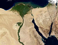
Delta and Nile Valley Viewed from Satellite
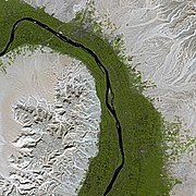
The Nile Valley Seen From Satellite

Locks on the Nile
View from a cruise, between Luxor and Aswan
Left margin of the river between Edfu and Kom Ombo

Kom Ombo on the right margin of the Nile

The first Nile Fall

Presa de Asuán
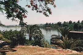
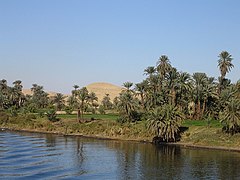
The Nile in The Miniya
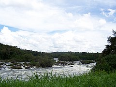
The Nile in Uganda
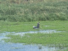
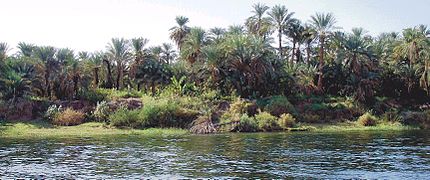
Flora and fauna of the Nile
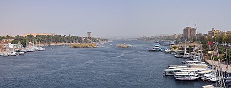
The Nile in Aswan

The Nile near Luxor

The Nile in Luxor


.jpg)


Contenido relacionado
Hardap Region
Cap haitian
Hiroshima