Mount Gimie

format_list_bulleted Contenido keyboard_arrow_down
ImprimirCitar
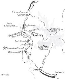
Map of the southeast of Saint Lucia indicating Mount Gimie.

Mount Gimie is located in the central part of the island of Saint Lucia, a small country located south of Martinique and north of Venezuela, Trinidad and Tobago, and Saint Vincent and the Grenadines, in the waters of the Caribbean Sea. With a height of 950 meters above sea level, it is considered the highest peak in that nation. Its coordinates are 13° 51' north latitude and 61° 0' longitude in a westerly direction, very close to the Edmund Forest Reserve and the Enbas Saut Falls, east of Soufriere.

Contenido relacionado

Jumps

Brincones is a Spanish municipality and town in the province of Salamanca, in the autonomous community of Castilla y León. It is integrated into the...

Kiel

Kiel is the most populous capital and city of the federated state of Schleswig-Holstein, the northernmost of the states of Germany. The city extends around...

Olvera

Olvera is a Spanish municipality and town in the province of Cádiz, in the autonomous community of Andalusia. It is included in the Sierra de Cádiz region...
Más resultados...
Tamaño del texto:
undoredo
format_boldformat_italicformat_underlinedstrikethrough_ssuperscriptsubscriptlink
save