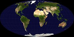
Mollweide projection
The Mollweide projection, also known as the Babinet, is a pseudocylindrical, equal mapping projection, generally used for maps of the Earth or the night sky.
The projection was first published by the mathematician and astronomer Karl Mollweide (1774–1825) of Leipzig in 1805. It was reinvented and popularized in 1857 by Jacques Babinet, who gave it the name of the homalographic projection.
Its purpose is to represent the ratio of areas as accurately as possible.
Properties
The equator is twice as long as the short axis, the central or type meridian, is straight. Meridians at 90° are circular arcs. The parallels are straight but unequally spaced. The scale is false only along the standard parallels of 40:44N and 40:44S, so it has a greater representation by the equatorial zone. The Mollweide projection is used for world maps, especially to represent low latitude areas.
Mathematical formulation
Latitude and longitudes in x and y coordinates by means of the following equations:
where θ is an auxiliary angle defined by
y λ is longitude, λ0 is the central meridian, φ is latitude, and R is the radius of the balloon to be projected. The map has an area of 4πR2, according to the surface of the generating globe. The x coordinate has a range of [−2R√2, 2R√2], and the y coordinate has a range of [−R√2, R√2].
Equation (1) can be solved with fast convergence (but slow near the poles) using the iteration of the Newton–Raphson Method:
If φ = ±π2, then also θ = ±π2. In that case iteration should be avoided; otherwise, it could result in division by zero.
There is a closed form of inverse transformation:
where θ can be found by the relation
Inverse transformations allow you to find the latitude and longitude corresponding to the x and y coordinates.
Contenido relacionado
Azimuthal projection
Comoros
Uranus


![{displaystyle varphi =arcsin left[{frac {2theta +sin left(2theta right)}{pi }}right],,}](https://wikimedia.org/api/rest_v1/media/math/render/svg/659885e4072f82558ef9e631bc77d7fd6aa3c4d6)

