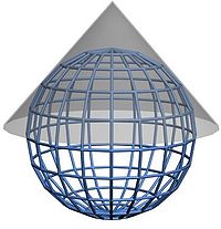
Map conic projection
The conic projection is the cartographic projection represented by maps made using cylindrical projections. It is a tangent projection, which touches one line with another, projecting the elements of the earth's spherical surface onto a geometric surface (cone).
The inventor of this projection is the German mathematician Johann Heinrich Lambert who in 1759 published a book with diverse reflections about the projection, the writing was titled "Freye Perspective" (There was a second improved edition in 1774).
The cartographic conic projection is obtained by projecting the elements of the earth's spherical surface onto a conical surface tangent or secant to the sphere, taking the vertex on the axis that joins the two poles.
In the conical projection, the meridians are transformed into straight lines that start from the pole and the parallels into concentric circles centered on it. The map resulting from extending the cone in a plane is a circular sector greater or less than a semicircle. The parallel or parallels of contact between the cone and the sphere are called reference parallels, and on it the scale is the same as on the original globe. The deformations increase as you move away from the reference parallel. When the parallels maintain the same distances from each other they are equidistant.
The shape and area of the surface stay the same at mid-latitudes. The image projected on the conical surface "unfolds", resulting in a flat drawing, easily reproduced on a sheet of paper.
In this projection an asymmetric distortion originates that affects, to a great extent, the polar areas, but offers acceptable precision in the areas of the hemisphere where the projection cone is tangent.
It is used, preferably, to represent those countries that are located in mid-latitude regions, as the resulting distortion is less.
Contenido relacionado
Juan Carlos I of Spain
Greenland
Geography
