Manzanares River
The Manzanares is a river in the center of the Iberian Peninsula, a right-hand tributary of the Jarama, which in turn is a tributary of the Tagus. This river, which runs entirely through the Community of Madrid (Spain), rises in the Sierra de Guadarrama, in the Ventisquero de la Condesa —the southern slope of the Cuerda Larga, near the Bola del Mundo— and passes through the city of Madrid. It flows into the Jarama River, in the municipality of Rivas-Vaciamadrid, after a journey of 92 kilometers.
The river is home to different ecosystems and crosses areas of great environmental value, which have received different levels of protection. Its upper basin, from its source to the El Pardo mountain (including La Pedriza), constitutes the Cuenca Alta del Manzanares regional park, with an area of 52,796 hectares. Its lower course is also protected, within the Southeast regional park.
In its urban route, the course of the Manzanares is the result of decades of channeling and damming works, although in 2016 the river level was returned to the original flow at the height of Madrid by opening the regulating gates, which produced an increase in biological diversity in this stretch.
Course
High Course
The Manzanares has its source in the Ventisquero de la Condesa, an area at 2,190 meters of altitude located on the southern slope of the Cuerda Larga and presided over by the peaks of the Alto de las Guarramillas (2,262 m), known as the Ball World for the television repeater installed in it, and the Valdemartín hill (2282 m).
Its source is made up of different springs and snowdrifts or snowdrifts, accumulations of snow that remain well into spring. It is located in the municipality of Manzanares el Real, a municipality from which the river takes its name and to which it heads after descending through La Pedriza, a place of granite formations declared a Biosphere Reserve.
In its first section, the river flows in a northwest-southeast direction and runs along a narrow and shallow channel, flanked by ridges. When it reaches 1,300 m above sea level, it heads east, but soon returns to the southeast, shortly before entering the Camorza gorge. At this point, it is once again boxed in between large rock formations, carving out numerous pools and basins on the stone, which it saves through waterfalls and pools.
It then heads east and, when it reaches the area known as El Tranco, turns south. Before entering the urban area of Manzanares el Real, leave the Peña Sacra hermitage on the right and cross the Manzanares Mill. This entire section runs through the bottom of the Manzanares gorge.
It crosses the town of Manzanares el Real, where it borders the Mendoza castle, one of the main monuments it encounters on its route. At its feet it is retained by the Santillana reservoir, which was built in 1907 for the production of electricity, although the primitive facilities were replaced in 1971 and converted to supply drinking water.
The river then heads south, towards the municipality of Colmenar Viejo, where it still behaves like a mountain river. In the aforementioned town, old bridges, fulling mills and mills are preserved, built for the hydraulic use of the river, as well as different facilities of the Santillana canal, begun in 1898. The Batán and Grajal bridges stand out, both of medieval origin.
Intermediate course
The river crosses the El Pardo mountain, where it widens its valley, a protected area that belongs to the municipality of Madrid. Here it supplies water to the El Pardo reservoir, which was built to regulate the channeling dams of the river as it passes through the capital. At this point, the Manzanares crosses areas of dense holm oak and pasture, in what constitutes one of the best-preserved Mediterranean forests in Europe, and serves as a biological corridor for numerous species of fish, mammals, birds, reptiles and amphibians, some of which of them protected by the Community of Madrid, who live there. There are numerous backwaters in this area.
The Manzanares river then crosses the town of El Pardo, integrated into the municipal area of Madrid, where it leaves the Royal Palace of this town on its left. Later it forms a pond, called Playa de Madrid, formerly used as a bathing area. It then passes next to the recreational and sports areas of Somontes and Puerta de Hierro and skirts the Hipódromo de La Zarzuela.
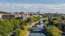
He heads towards the Puerta de Hierro, which formerly marked the boundary between Madrid and El Pardo; it crosses the La Coruña highway (A-6) and, from the French bridge, it enters the urban area of Madrid. It crosses the city channeled, circumventing different dams that regulate its waters to guarantee a constant flow and allow certain recreational uses, such as the pier of the Segovia bridge.
Crossing the old Arganzuela pasture, the Manzanares river leaves its southwestern area on its right (Casa de Campo, Latina, Carabanchel, Usera and Villaverde) and the rest, including the downtown area, on its left. The flow of the river increases significantly, as a consequence of the discharges from the capital, previously purified through an integral water cycle system.
Throughout the municipality of Madrid, the river crosses some monumental bridges. The French Bridge, built in the second half of the 19th century century, gained crucial importance during the Civil War. Further down is the Queen Victoria Bridge (1908-1909), which has certain modernist airs, and the King's Bridge (1816). After skirting the Virgen del Puerto hermitage, you come across the Segovia Bridge, the oldest in the capital, attributed to Juan de Herrera, from the XVI.
It passes next to where the Vicente Calderón stadium (also known as the Manzanares stadium and demolished in 2020) was located, and then heads towards the Toledo bridge. The work of Pedro de Ribera, it was built in the XVIII century to the mockery of neighbors and intellectuals ("a lot of bridge for such a small river »).
In the rest of its journey through the urban area of Madrid it crosses several more bridges dating from the XX century, between which are the bridge of Prague and the bridge of Andalusia or the Princess.
Until 2007, the river crossed Madrid attached, on its two banks, to the M-30, a ring road of the city. The burying of this, promoted by the mayor Alberto Ruiz-Gallardón, meant the recovery of its banks.
Low Course
The river leaves Madrid at its southern end (where it borders a riverside park, known as Parque Lineal del Manzanares), after traveling 30 km through its municipal area, that is, a third of its total length. At this point it turns east, crossing the district of Perales del Río, belonging to Getafe, where it forms different meadows.
He then heads towards Rivas-Vaciamadrid. In this term, it runs next to the cliffs and cliffs of La Marañosa, practically in parallel with the Jarama river, where it finally flows, near the Rey dam.
The lower course of the river is protected within the Regional Park of the lower courses of the Manzanares and Jarama rivers, better known as the Regional Park of the Southeast of Madrid, created in 1993. This natural space, characterized by the abundance of materials gypsum and limestone, includes areas of great ecological, paleontological and archaeological value.
Tributaries
In its upper course, the Manzanares receives numerous streams and streams. The first that pours its waters into the river is the Valdemartín stream, in the Manzanares el Real district. Without leaving this municipality, it is later joined by the Simón de los Chorros stream, at an altitude of 1,300 meters, which, in turn, receives the La Mata stream. One hundred meters below, it is fed by the Los Hoyos de la Sierra stream, formerly called the Cuervo stream, which in turn collects the waters of the La Covacha and El Chivato streams. Further on, the streams of La Garganta and La Majadilla converge. At the height of the Santillana reservoir, it meets the Samburiel river, one of its main tributaries, regulated in the Navacerrada reservoir. The Arroyo Mediano, which comes from the term of Soto del Real, is also a tributary.
In its middle course, the list of tributaries is also numerous. Coming from the Hoyo de Manzanares mountain range, the Manina and Trofas streams arrive, which flow into the river at the height of the El Pardo mountain, in the municipality of Madrid. The streams of La Nava, Tejada and La Zarzuela also pour their waters into this area. With regard to the urban area of the city, the Manzanares receives the streams (currently channeled or buried) of Meaques, Abroñigal and Butarque, which are born in low mountains.
The most important tributary with which the Manzanares meets in its lower course is the Culebro stream, a current of about 28 km in length, which runs through Leganés, Fuenlabrada, Pinto and Getafe and which flows into the latter municipality.
History
The Manzanares River, despite its scant geographical relevance, has had great historical importance, as a result of its close relationship with Madrid, the capital of Spain. In fact, the city emerged as a Muslim fortress in the IX century, to defend the existing river path along the river, threatened by the advance of the Christian kingdoms, during the Reconquest.
Much earlier, in Prehistory, the river had hosted intense human activity, not only in the current municipality of Madrid, but also at other points along its course. There are archaeological sites that show the presence of settlers on its terraces since Paleolithic times. In the Middle Ages, the Real de Manzanares was built around its upper basin, an extensive and influential manor under the control of the House of Mendoza, which was disputed by the councils of Madrid and Segovia.
The Manzanares was formerly known as Guadarrama, a name reserved today for the river that runs from the Fuenfría valley to the Tagus, passing through the towns of Guadarrama and Collado Villalba. In the XVII century, the Duke of Infantado decided to change its name, calling it the same as its main estate, the Real de Manzanares, whose most important town was the current town of Manzanares el Real. regulated fishing in the city's river. This is the case of the following quote, taken from the Charter:
The one who kills fish in the Guaderrama [by the present Manzanares], from the Easter day of the Holy Spirit or Cincuesma to San Martín with asedega or with mandil or sleeve, peche dos maravedises prior probanza.
In the 17th century the channeling of the Tagus and Manzanares rivers was planned to make them navigable. A Board was appointed for its study and, shortly after, the Board, reviewing the enormous technical difficulties and enormous financial resources required, gave the answer rejecting the work with the following argument:
If God had hoped that both rivers would be navigable, with only one factiat would have done so, and it would be injurious to the rights of Providence to improve what it, for unscrutable reasons, had wanted it to be imperfect.
In the 18th century an ambitious engineering work was undertaken that was never finished, the objective of which was to communicate the waters from the nearby Guadarrama River with those of the Manzanares and the Tagus, until reaching the Guadalquivir and the Atlantic Ocean, through a navigable channel of almost 800 kilometers, originating in the El Gasco dam, in Torrelodones.
From the establishment of Madrid as the capital in the XVI century until the second third of the XIX, the banks of the river were used as washing places for clothes as they passed through the city. At present there are remains of the old facilities of the Casa-Lavadero de Policarpo Herrera (which came into operation in 1831), next to the Toledo bridge, and of two laundry houses between the Rey and Segovia bridges, as well as some artificial channels, dug parallel to the riverbed to facilitate the work of washerwomen.
The river channeling works near the city of Madrid began in 1914, with a project by engineer Eduardo Fungairiño, and did not finish until 1925. On the banks of the river as it passes through Madrid, especially In the vicinity of the Reina Victoria Bridge, you can see several Ionic columns that are nothing more than vents for an underground collector built in the 1920s. In the 1930s, the Manzanares was an important defensive line in Madrid during the Civil War.
In 1970 there was a spill of radioactive material from the Juan Vigón National Nuclear Energy Center located in Ciudad Universitaria, reaching the banks of the Jarama and the Tagus, an event that was kept secret by the government of the dictatorship. The contaminated sludge was buried without markings at eight points in the Jarama basin, of which only four are known with certainty.
The Manzanares has traditionally been considered a river with low flow. In this sense, a German diplomat would declare, ironically, that the Manzanares was "navigable by car and on horseback". The fitting out of a series of locks in the 50s to regulate the flow and raise the water level allowed the use of the for the practice of canoeing and rowing. Various improvements were also made to the natural and urban environment, generating a greater area of trees, pedestrian walkways and recreational spaces. After six kilometers of the M-30 ring road were buried in 2007, it was created around the banks from the river course the park known as Madrid Río. In the summer of 2012, the section that crosses the capital experienced an unusual proliferation of algae, attributed to the heat and low flow. In 2014, an invasion of Vietnamese pigs on the banks of the river was stopped by the Municipal Police.
In 2016, the City Council decided to open the floodgates to proceed with what it called "renaturation" of the river, which favored the formation of islets and the growth of low vegetation and trees in the riverbed, by eliminating pools of dammed water. This process improved water quality and recovered biological diversity, which had disappeared with the lock system. The process also allows the river to act as an ecological corridor, connecting the populations of species to the north and south of the region.
The Manzanares in art
 Wikimedia Commons hosts a multimedia category Manzanares River in Art.
A river with a low flow, it has been the object of constant satire by novelists and poets. Francisco de Quevedo said in one of his poems: "Manzanares, Manzanares, arroyo apprentice river." Tirso de Molina, on his part, lashed out at his & # 34; Cigarral Tercero & # 34; (1624) against the Madrid river in this way: «Like Alcalá and Salamanca you have / (and you are not a school) vacations in summer / and courses only in winter». Luis de Góngora was dispatched like this, after a flood: «¿ How yesterday I saw you in pain, and today in glory? A donkey drank me yesterday, and today it pissed me."
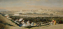
The river has inspired painters. This is the case of some of the best-known paintings by Francisco de Goya (The meadow of San Isidro, Dance on the banks of the Manzanares river, La merienda), in which the inhabitants of Madrid are shown in traditional clothing in activities such as games, pilgrimages or festivals on the banks of the river. The Aragonese painter lived since 1819 in the Quinta del Sordo, a farm located on the banks of the Manzanares. At the end of the XIX century and At the beginning of the XX, Aureliano de Beruete painted the banks of the river on some of his canvases (Orillas del Manzanares, Manzanares Washhouses, The Manzanares under the French Bridge).
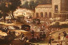
Most of the old drawings and engravings of Madrid reflect the city from its western end, with the Manzanares in the foreground. In some of them, the river appears oversized: a current of great volume is reflected, in which even islands and boats that cross its course appear.
In the field of photography, several artists have captured the river. One of the most important is Alfonso Sánchez García, better known as Alfonso, author, among other works, of the photograph Lavaderos del Manzanares.
Contenido relacionado
Hydraulic energy
Tikrit
Annex: Municipalities of the province of Seville


