Malaysia geography
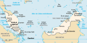
The Federation of Malaysia is in Southeast Asia. It is made up of Peninsular Malaysia (131,588 km², 40% of the territory) and East Malaysia, made up of the states of Sarawak (124,450 km²) and Sabah (73,711 km²), 60% of the territory, in the northern part of the Borneo Island (Kalimantan), located in the Malay Archipelago, about 640 km from Peninsular Malaysia.
Malaysia's total area of about 330,000 km² makes it the 66th largest country in the world, and it is the only country that contains both land in Asia and the Malay Archipelago. Of the terrestrial total, 1200 km² (0.37%) are formed by lakes, rivers and other aquatic surfaces.
Malaysia has a total of 4,675 km of coastline, of which 2,068 km correspond to Peninsular Malaysia and 2,607 km to East Malaysia. In statistical terms, it is the 29th longest coastline in the world. Both the southern and insular parts have similar landscapes of coastal plains followed by hills and mountains.
Peninsula Malaysia and East Malaysia are separated by the South China Sea. Off the west coast of Peninsular Malaysia is the 800 km long Strait of Malacca, which separates it from Sumatra, bordered on the north by the Andaman Sea. The Strait of Malacca is one of the busiest shipping lanes in the world. To the south of the peninsula is Singapore, separated by the Strait of Johor and linked by the road levee or Johor-Singapore causeway, 1 km long. The northeastern coast of the peninsula faces the Gulf of Thailand. For its part, the northeast coast of Sabah, in East Malaysia, faces the Sulu Sea, and the southeast coast, the Celebes Sea.
The country, a federation of 13 states and 2 territories, is a member of the British Commonwealth. It is also a constitutional monarchy with a king elected for 5 years from among the sultans of Peninsular Malaysia. The subsoil (gold, iron, bauxite, etc., in the western part), plus off-shore gas and oil (in the eastern part) are, along with wood and rubber, the country's main resources.
Half the population is Malay (Muslims), 35% Chinese (Buddhists) and 10% Indian (Hindus), and they occupy 3/4 parts of the peninsula.
Peninsular Malaysia
Peninsular Malaysia (south of Thailand) covers the southern half of the Malay Peninsula and stretches 740 km from north to south, with a maximum width of 320 km. It is mountainous, with an average height of 150 m above sea level.
It is divided from north to south by a long mountain range, the Titiwangsa Mountains, 480 km long, culminating in the 2,183 m Mount Korbu and which are the continuation of the Tenasserim Mountains, which separate Burma from Thailand more to the north. The eastern part of this chain, formed by parallel mountain ranges, is known as Bintang, and culminates in Mount Bintang, 1,862 m. These mountains divide the peninsula into an eastern and western coast.
Large areas of forest are found in this region. Half of the peninsula is made up of granite and other igneous rocks, another third is made up of metamorphic rocks, and the rest is covered in sedimentary rocks. Karst landscapes are common in the center and north of the peninsula, with escarpments, sparse vegetation, and caves formed by erosion.
The western coast is the most fertile, since it is made up of plains due to river sediments, and it is the most favorable for ports. Even so, in general the soil is poor, heavily washed by the rains, and fertilizers are needed for agriculture. The western coast of the peninsula, which is 15 to 80 km wide, is by far the most populated, facing the Strait of Malacca, and among the cities is the capital, Kuala Lumpur (7,600,000 inhabitants). The eastern coast is much narrower and more discontinuous.
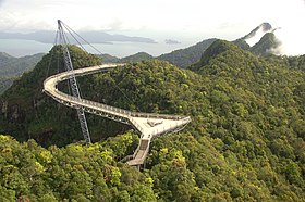
In the Andaman Sea, about 30 km off the coast in northwest Peninsular Malaysia is the Langkawi archipelago, made up of 104 islands, bordering the Thai border, with a combined area of about 480 km². Since 2007, the islands have the status of a UNESCO Langwaki Global Geopark.
East Malaysia
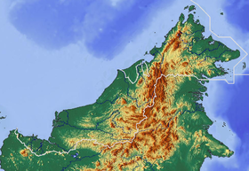
East Malaysia, made up of the states of Sarawak, Sabah and the Federal Territory of Labuan, is located north of the Indonesian part of Borneo (Kalimantan) and next to the enclave of the Sultanate of Brunei. It is made up of a long strip of land 1,125 km long by about 275 km wide. The coastal region is 30 to 60 km wide in Sarawak and 15 to 30 km in Sabah, where the coastline is more jagged and indented. It is followed by a region made up of hills and valleys between 300 and 750 m high, very rugged, and finally, a mountainous region that separates the country from Kalimantan, made up of plateaus, ravines and gorges between 1,200 and 2,100 m high.. The main mountain range is in Sabah, formed by the Crocker or Banjaran Crocker Mountains, culminating in Mount Kinabalu, 4,100 m, followed by the nearby Mount Tambuyukon, 2,579 m. This area is part of the Kinabalu National Park and was declared a UNESCO Biosphere Reserve in 2014. This chain is located in the northeast of the island and is parallel to the north coast.
The rest of the mountain ranges in East Malaysia tend to follow a north-south or northeast-southwest orientation, with the highest peaks separating Indonesia from Malaysia. Many peaks, like the entire region, are limestone. In the Trus Madi chain is the second peak of Malaysia, Mount Trus Madi, 2,642 m. The country lacks mountains between 3,000 and 4,000 m.
In the far northeast of the country is a volcanic field topped by the 531 m high Bombalai volcano. Located in front of Semporna, it gives rise to the most fertile lands in the country.
East Malaysia is less populated than the mainland. Being larger, there is only 20.4% of the country's population, although it owns 60% of the territory. There are two notable cities: Kuching (325,000 inhabitants) and Kota Kinabalu (452,000 inhabitants).
In Sabah there are several islands in the north of the state. The Banggi Island stands out, with an area of 440 km². For its part, in Sarawak the island of Bruit stands out, of approx. 530 km².
Geology
Malaysia is located on the Sunda Plate and is tectonically inactive. The oldest rocks in the country date back 540 million years and are found on the Langkawi Islands and Peninsular Malaysia, west of the Titiwangsa Mountains, in the form of sandstone and quartzite on the islands, and Cambrian and Paleozoic rocks (granite and schists) on the peninsula. Granitic rocks dominate more than 50% of Peninsular Malaysia. The northwest and a part of the north-south mountain belt is covered with Mesozoic sediments. The most common rock is limestone, formed during the Paleozoic.
In East Malaysia, sedimentary rocks predominate, including limestone, except in the extreme northeast, where there is the Bombalai volcanic field. In the center, near the border with Brunei, where Sabah and Sarawak separate, is the Gunung Mulu National Park, dominated by three mountains, the sandstone Mount Mulu (2,376 m) and the Api Mountains (1,750 m). and Benarat (1,858 m) of limestone. Among the caves below them, the Sarawak grotto stands out, 700 m long, 400 m wide and 70 m high, one of the largest in the world; Deer Cave, with the world's largest passageway, 146 m wide at the entrance, over 1 km long and 122 m high, and the Clearwater cave system, the world's largest of interconnected caves, with 222 km known in 2017. The mountains and caves formed between the Eocene and Miocene periods topped by a tectonic upheaval between 2 and 5 million years ago. The pinnacles of Mount Api are the result of the region's extremely humid climate with rainfall of between 4,000 and 5,000 mm per year.
In Peninsular Malaysia there are four oceanic sedimentary basins, the Malacca Basin and Penyu Basin lie offshore to the east of the peninsula, and the Central Sumatra Basin and North Sumatra Basin lie to the west. In East Malaysia, there are three marine basins in Sabah, the Sabah basin to the northwest being the main one. The Sarawak region is so large that it has been divided into on-island and off-island geological provinces. In all cases, the thickness of the sediments ensures the presence of oil and natural gas. Oil has been extracted in the Malacca basin since the 1960s; it is about 500 km long by 200 km wide. The Spanish company Repsol has interests in the Kinabalu field, a mature offshore field located in the Malaysian Sabah basin.
Hydrology
The longest river in Peninsular Malaysia is the Pahang River, which is 459 km long. In East Malaysia, the Kinabatangan River, 560 km long, in Sabah, and the Rajang River, 563 km long, in Sarawak, stand out. The Bakun Reservoir has been built on one of the Rajang tributaries, the Balui River, with a 205 m high dam, a flooded area of 695 km² and an installed capacity of 2,400 MW.
In the northeast of Peninsular Malaysia, in the Malay sultanate of Terengganu is the largest artificial lake in Southeast Asia, the lake or reservoir of Kenyir, created in 1985 on the Kenyir river to provide water for the sultanate. It has 370 km², a 150 m high dam and produces 400 MW. The hydroelectric station is also named after Sultan Mahmud.
Another man-made lake in the region is Lake Pedu, in the northwestern Padang Terap district, on the border with Thailand. The lake is 75 km² and is part of the Ulu Muda and Pedu Lake Forest Reserve, which covers 1,228 km² of virgin forest.
The only two natural lakes in Malaysia are the 260 km² Ramsar Site Bera Lake and the 51 km² Lake Chini, both in Pahang, Peninsular Malaysia.
Climate
The climate of Malaysia is equatorial, hot, humid and rainy all year round. Temperatures are high and stable, with a slight drop between November and January, with highs of 29-30.o C, although when it's hotter, between March and August, they barely rise to 32-33. orC. On the other hand, it is difficult to find a place where less than 2000 mm falls annually, and a month in which less than 100 mm falls. Malaysia is exposed to the monsoon, which can cause very heavy rains in areas exposed to winds that prevail from the northeast between mid-October and January (particularly affecting the east coast and northeast Borneo) and from the southwest between June and September, in a weaker way. The rains are usually stormy and in the afternoon.
Climate of Peninsular Malaysia
In Peninsular Malaysia, the east coast is directly affected by the northeast monsoon, with annual rainfall between 2,500 and 3,000 mm, exceeding 500 mm in November and December. For example, in Kota Bharu, in the north of Peninsular Malaysia, 2,940 mm falls in 178 days, with more than 600 mm in November and December, with 21 days of rain, more than 200 mm in September, October and January, and more the rest were 100 mm, with a minimum in April of 115 mm in just 9 days. Temperatures vary little, from 23-29.oC in January to 24-33.oJune C. On the west coast, rainfall decreases to 1,800-2,500 mm, because the peaks of November and December do not occur. For example, in the Langkawi archipelago, to the northwest, 2,300 mm falls in 182 days. Here they exceed 300 mm in September and October, 200 mm between March and November and fall less than 100 mm between December and March with a minimum of 45 mm in February. Temperatures range year-round between 24 and 33.oC.
In Kuala Lumpur, in central Peninsular Malaysia, 2,425 mm falls, with more than 200 mm between March and May, and between October and December, and a minimum of 125 mm in June and July. Same temperatures all year round, between 23 and 33.oC of minimum and maximum daily averages.
Climate of East Malaysia
In East Malaysia, on the island of Borneo, it rains more. In Kuching, in the southwest, exposed to the northeast monsoons due to the shape of the relief, 4,115 mm fall in 207 days, with a maximum in January that can reach 700 mm in 22 days, and a minimum in July of 185 mm in 13 days; the other months exceed 200 mm, with almost 500 mm in December and February. On the part of the coast not exposed to northeasterly winds, it rains less; in Bintulu 3580 mm fall, with a peak of 420 mm in December and more than 200 mm the rest of the months. North of Brunei, a decline is indeed noticeable, with just 2,545mm in Kota Kinabalu, peaking at 345mm in October and less than 100mm in February and March. Following the coast to the east, again oriented to the northeast monsoon, at Sandakan, 3015 mm falls, with more than 400 mm in December and January, and less than 200 mm between March and June.
In the most protected area of the monsoon, in Tawau, in the extreme east of Malaysia, 1765mm falls, with 100mm in February, March and April, and only exceeding 200mm in July and August.
In the high areas, temperatures decrease. Mount Kinabalu, on the island of Borneo, exceeds 4,000 m. In Peninsular Malaysia, several peaks exceed 2,000 m. At Tanah Rata, in the Cameron Highlands, at an altitude of 1,470 m, temperatures, very even, range from 13 to 22 throughout the year.oC. The average precipitation is 2,586 mm, exceeding 300 mm in October and November.
Forests
Approximately 58% of Malaysia is covered by tropical forests. Most of it belongs to the lowland rainforests of Borneo ecoregion, dominated by dipterocarps, with about two thousand tree species. However, since the 1960s, up to 80 percent of the forest has been cleared in Sarawak. <The waters have been polluted and the land has eroded. In Malaysia there are also about 1,425 km² of mangroves and numerous swamps.
In order to conserve the wild regions that still exist, parks, reserves and national parks have been created, among which the Kinabalu National Park and the Gunung Mulu National Park stand out.
Malaysia Protected Areas
According to the IUCN, in Malaysia there are 717 protected areas that cover a total of 63,419 km², 19.12% of the territory, and 6,978 km² of marine areas, 1.54% of the 451,742 km² that belong to the country. In this set, 29 are national parks, 1 is a marine reserve, 1 is a natural monument, 4 are nature reserves, 24 are marine parks, 345 are forest reserves, 3 are ASEAN heritage national parks, 12 are ASEAN sanctuaries. nature, 42 are protected forest reserves, 33 are wildlife reserves, 123 are virgin jungle reserves, 23 are protected forests, 28 are communal forests, 6 are bird sanctuaries, 17 are mangrove forest reserves, 1 is a turtles, 1 is a national historical monument and the rest acquire different consideration. In addition, there are 7 Ramsar sites, 1 is a Unesco biosphere reserve and 2 are world heritage sites.
Raw data
Climate: tropical southwest monsoon from April to October, northeast from October to February.
Relief: coastal plains, hills and mountains in the interior.
Natural resources: tin, oil, timber, copper, iron ore, natural gas, and bauxite.
Exploitation of the land:
- Arable land: 3%
- Permanent crops: 12 per cent
- Permanent pastries: 0%
- Forests: 68% (1993 est)
Irrigated land: 2,941 km² (1998 est.)
About half of the Malay Peninsula is covered by granite and other magmatic rocks. A third part presents rocks other than granite, the rest is covered by alluvium.
Environmental problems: air and water pollution, deforestation.
Natural disasters: floods, landslides.
- It is part of: Biodiversity, Climate Change, Desertification, Threatened Species, Sea Law, Preservation of Marine Life, Prohibition of Nuclear Tests, Protection of the Ozone Layer, Tropical Forest 83, Tropical Forest 94, Wet Areas.
- Signed but not ratified: Kyoto Protocol.
National Parks: In its six national parks, the Federation of Malaysia strives to preserve primeval rainforest.
Fonts
- CIA World Factbook
Contenido relacionado
Martinique
Geography of Russia
Eibar


