Malawi Geography
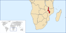
Malawi is a country located in East Africa. It limits to the west with Zambia, to the west, south and east with Mozambique and to the north with Tanzania. It is administratively divided into three regions: the northern region, with its capital in Mzuzu, the central region, with its capital in Lilongwe, which is also the nation's capital, and the southern region with its capital in Blantyre. To the east of the country is Lake Malawi, the third largest on the African continent.
Geographically, as you move from the border with Zambia and Mozambique to Lake Nyassa, the country descends in elevation until it reaches Lake Malawi and the valley of the Shire River, which empties into the Zambezi River. In the same way, the climate varies from temperate in the heights to 25 °C in the low areas.
Malawi is one of the most densely populated countries in sub-Saharan Africa. With 16.5 million inhabitants, it has a density of 130 inhab/km². The capital, Lilongwe, had more than 800,000 inhabitants in 2013. The second largest city in the country is Blantyre, in the south, with 750,000 inhabitants, followed at a long distance by Mzuzu, with 154,150 inhabitants, and Zomba, with 98,800 inhabitants.
Relief
Malawi is crossed from north to south by the Great Rift Valley, at the bottom of which is Lake Malawi, also called Lake Niassa, which occupies 25 percent of the country and three-quarters of the eastern border with Tanzania and Mozambique. Niassa Lake is sometimes called Calendar Lake because it is 365 miles long and 52 miles wide, 587 km and 84 km respectively. The Shire River flows from the southern end of the lake, through Malawi, across the border with Mozambique, and 400 km later joins the Zambezi River.
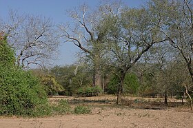
The western part of Malawi is a mountainous upland that parallels the Rift Valley from south to north; in the south and centre, the plateau rises to 900-1,200m, but in the north is the Nyika Plateau, a protected area jutting into Zambia above 2,000m, peaked at Mount Nganda, 2,605m m. The entire western region of the lake is part of the Central Zambezi miombo bushveld ecosystem.
To the south of Malawi and Lake Niassa lies the Shire Plateau, east of the Shire River, an elongated plateau 130 km in length with elevations of 600 to 900 m and peaks at Rise Thyolo (1,462 m), Ndirande (1,612 m) and Chiradzulu (1,773 m). The highest point is the Zomba Plateau, at 1,800 m, with extensive stands of cedar, pine, and cypress. From the top, it is possible to see Lake Chilwa to the north; the Shire River to the west and the Mulanje Massif to the east, a group of isolated mountains rising from the surrounding highlands of Chiradzulu district and the tea fields of Mulanje district, reaching 3,002 m at the peak of Sapitwa, the highest in the country.
Climate
Malawi is south of the equator; It has a warm tropical climate with a more temperate zone in the northwestern mountains, and two very marked seasons, a warm and rainy season from November to April, the summer of the southern hemisphere, and a relatively cool and dry season from mid-May to mid-August.. Before the rainy season, in November, temperatures reach a maximum; above 1000 m altitude they are much softer. The south, at a lower altitude, suffers from the hottest climate.
In most of the country, rainfall ranges between 800 and 1,300 mm, somewhat more abundant in the north and on the slopes of the Mulanje massif in the south, where it exceeds 2,000 mm.
The capital, Lilongwe, at 1,100 m altitude, in the northern part of the southern third of the country, receives 846 mm per year in 58 days, between the months of November and mid-April, exceeding 200 mm in January and February, with temperatures those months between 14.oC and 26.oC. Between May and October it does not rain, and temperatures drop a lot at night, with average lows of 6-7. oc and highs of 23-25.oC between June and August.
In Blantyre, the second largest city in the country, at an altitude of 1,000 m, the climate is similar, it rains a little more, 1,086 mm, with an annual average of 20.7.oC. However, lows barely dip below 12.oC in July.
On the shores of Lake Niassa, in Karonga, in the north, at an altitude of 478 m, 1,170 mm fall, almost all between November and May; average temperatures range from 21.oC in January to 26.oC in November, when it is hottest.
In the far south, on the banks of the Shire River, at Nsanje, at only 55m elevation, 900mm falls between November and March, but it doesn't stop raining for the rest of the year, and temperatures exceed 36.oC mean in October and November, with mean minimums of 14.oC in June and July.
Finally, in Mzuzu, the third largest city in the country, in the north, at an altitude of 1,250 m, there are about 1,300 mm of rain a year, temperatures drop below 7.oC in July and August and reach 28.oC on average in November.
Malawi National Parks
Malawi is rich in nature, including most of the continent's large mammals, including Africa's Big Five: buffalo, elephant, lion, leopard and rhinoceros. Altogether, there are about 170 species of mammals and about 600 known species of birds.
As a highly populated country, animals are relegated to the five national parks and various game reserves, including Lake Malawi, which contains unique fish species. From north to south:
- Nyika National Park, created and expanded in 1965-1978: 3.134 km2, in the north, in the Nyika Plateau, with an average altitude of 1800 m. The name means "where the water comes from." Borde Zambia to the west; wooded grasslands, endless hills, some perennial forests in the valleys. Zebras, elands, antelopes of Liechtenstein, kudus, duikers, facoceros, etc.
- Kasungu National Park, created in 1970; 2,316 km2; in the west center, on the border with Zambia; open miombo forest with numerous rivers; hippos, elephants, antelopes, kudus, impalas, etc.
- Parque Nacional del Lago Malaui, created in 1980; 94 km2, at the southern end of the lake, where there is a small archipelago of twelve islands, opposite Corporal Maclear, where diving is practiced to see fish, among them, the most remarkable, the mbuna. Corporal Maclear, on the Nankhumba peninsula, is also a natural reserve.
- Liwonde National Park, created in 1973; 580 km2, south, on the banks of the Shire River, between Lake Malaui and Lake Malombe. Bananas, lagoons and reeds by the river, palm trees, pastures, kigelias and baobabs in the dry areas. The largest population of elephants in the country; hippos, antelopes, kudus, duikers and oribis in the areas of mopane.
- Lengwe National Park, created in 1970; 887 km2, at the southern end, low area on the right bank of the Shire River, border with Mozambique, forest and dambo wetlands of pastures and juncos. Famous for nyala antelopes; it is surrounded by sugarcane plantations and flooded in rainy season.
In Malawi there are also four game reserves adjacent to national parks:
- Majete hunting reserve (Majete Wildlife Reserve), 700 km2; north of the Lengwe National Park; low hills covered with open forests of Brachystegia and thick forests along the rivers; completely fenced, with restored fauna: elephants, rincerontes, buffaloes, leopards, lions, hippos, etc.
- Mwabvi Wildlife Reserve (Mwabvi Wildlife Reserve), 350 km2 south of Lengwe National Park; antelopes, lions, baboons. No elephants.
- Nkhotakota (Nkhotakota Wildlife Reserve), 1,8000 km2, the oldest and oldest in Malaui, downtown, on Lake Niassa. Forest of miombo, grasslands and perennial forest on Mount Chipata. Elephants, buffaloes, lions, hyenas, etc.
- Vwaza Marsh hunting reserve, 1000 km2 in the northwest, near the Nyika national park, border with Zambia, plain with mopane forest, miombo and Brachystegia. Hipopótamos and elephants crossing the nearby Luangwa North National Park, west, in Zambia.
Contenido relacionado
Saint Michael of Abona
Lambayeque Department
Geography of the Democratic Republic of the Congo


