
Macchu Picchu
Machu Picchu (pronounced /ˈmɐt͡ʃʊ ˈpɪkt͡ʃʊ/ in Quechua, «old mountain») is the contemporary name given to an llacta —an ancient Andean Inca settlement— built before the 15th century, located in the Eastern Cordillera of southern Peru, in the Andes mountain range at 2,430 meters above sea level. It is located in the department of Cusco (province of Urubamba, district of Machupicchu) on the Sacred Valley of the Incas, 80 kilometers northwest of the city of Cusco, city of Peru and where the Urubamba River flows, a river that crosses the mountain range and originates a canyon with a tropical mountain climate. According to many scholars, its original name would have been Llaqtapata.
According to documents from the mid-XVI century century, it had a private character. However, some of its best buildings and the evident ceremonial character of the main access road to the llaqta attests to its origin prior to Pachacútec and its presumable use as a religious sanctuary. Both uses, that of a palace and that of a sanctuary, would not have been incompatible. Even though its supposed military nature is disputed, so the popular descriptions of "fortress" or "citadel" could have been overcome.
Machu Picchu is considered, at the same time, a masterpiece of architecture and engineering. Its peculiar architectural and landscape characteristics, and the veil of mystery that has been woven around much of the literature published on the site, have made it one of the most famous tourist destinations on the planet, as well as one of the seven wonders of the world.
Machu Picchu was built in the classic Inca style, with walls of polished dry stone. Its three main structures are the Intihuatana, the Temple of the Sun and the Sala de las Tres Ventanas. Most of the outlying buildings have been reconstructed to give visitors a better idea of what they originally looked like. By 1976, 30% of Machu Picchu had been restored, and the restoration continues.
Machu Picchu was declared a Peruvian Historical Sanctuary in 1981 and has been on the Unesco World Heritage List since 1983, as part of a whole cultural and ecological complex known under the name Machu Picchu Historic Sanctuary. On July 7, 2007 Machu Picchu was declared one of the new seven wonders of the modern world in a ceremony held in Lisbon (Portugal), which was attended by one hundred million voters around the world. Machu Picchu was voted one of the New Seven Wonders of the World in a worldwide internet poll.
Etymology
In the Quechua language, machu means "old" or "ancient", while picchu means "peak, mountain or prominence with a broad base ending in points sharp'; therefore, the name of the site means "old mountain".
Geographic location
Location
It is located at 13° 9' 47" south latitude and 72° 32' 44" west longitude. It is part of the district of the same name, in the province of Urubamba, in the department of Cuzco, in Peru. The closest major city is Cuzco, the current regional capital and former capital of the Incas, 132 kilometers from there.
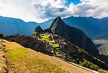
The mountains Machu Picchu and Huayna Picchu are part of a large orographic formation known as the Vilcabamba batholith, in the Central Cordillera of the Peruvian Andes. They are located on the left bank of the so-called Urubamba Canyon, formerly known as Quebrada de Picchu. At the foot of the hills, surrounding them, runs the Vilcanota-Urubamba river. The Inca archaeological site is located halfway between the tops of both mountains, 450 meters above the valley level and 2,438 meters above sea level. The built surface is approximately 530 meters long by 200 wide, with 172 buildings in its urban area. Biogeographically it is located in the ecoregion of the Peruvian Yungas.
The ruins themselves are located within an intangible territory of the National System of Natural Areas Protected by the State (SINANPE), called the Historic Sanctuary of Machu Picchu, which extends over an area of 32,592 hectares (80,535 acres or 325.92 km²) of the Vilcanota-Urubamba river basin (the Willka mayu or 'sacred river' of the Incas). The Historic Sanctuary protects a series of biological species in danger of extinction and several Inca establishments, among which Machu Picchu is considered the main one.
Forms of access

The archaeological zone is accessible, either from the post-Inca roads that reach it, or by using the Hiram Bingham highway (which ascends the slope of Machu Picchu hill from the old Puente Ruinas train station, located in the background of the canyon). Neither of the two forms exempts the visitor from the entrance fee to the complex.
The aforementioned highway, however, is not integrated into the national highway network of Peru. It is born in the town of Aguas Calientes, which in turn can only be accessed by rail (about three hours from Cuzco) or helicopter (30 minutes from Cuzco). The absence of a direct road to the Machu Picchu sanctuary is intentional and helps control the flow of visitors to the area, which, given its nature as a national reserve, is particularly sensitive to crowds. This, however, has not prevented the disorderly growth (criticized by the cultural authorities) of Aguas Calientes, which lives by and for tourism, since there are hotels and restaurants of different categories in this place.
| Route | Name | Description | Days | Price (2017) |
|---|---|---|---|---|
| 1 | km 82 | Pisqakucho-Kusichaca-Wayllabamba-Wiñaywayna-Machupicchu | 4 | 292.00 |
| 2 | km 88 | Qoriwayrachina-Wayllabamba-Wiñaywayna-Machupicchu | 4 | 292.00 |
| 3 | Salkantay | Mollepata-Silcakancha-Soraypampa-Lluskumayu-Lucmabamba-Sta Teresa-Hidroeléctrica-Aguas Calientes | 4 | 292.00 |
| 4 | km 82 | Pisqakucho-Qoriwayrachina-Papaymayu bas-Chanchabamba-Wiñaywayna-Machupicchu | 4 | 292.00 |
| 5 | km 104 | Chachabamba-Wiñaywayna-Machupicchu | 2 | 222.00 |
- On these prices there is a 50% discount for people over 60, disabled and students.
To get to Machu Picchu by the main Inca trail, you must hike for about three days. To do this, it is necessary to take a train or bus to km 82 of the Cusco-Aguas Calientes railway, which coincides with the limit of the Machu Picchu National Park, from where the walking tour starts. Some visitors take a local bus from Cusco to Ollantaytambo (via Urubamba) and from there they take a transport to the aforementioned km 82. Once there they travel the train tracks until they cover the 32 km that there are to Aguas Calientes. Currently, buses go to the hydroelectric plant located nine kilometers from Aguas Calientes, which takes approximately three hours to walk, which is the same path that the train takes.
Climate
The temperature is warm with humid air during the day, and cool at night, ranging between 12 and 24 degrees Celsius. The area in general is very rainy, especially between November and March. The rains, which are abundant, alternate rapidly with moments of intense sunlight.
| Month | Ene. | Feb. | Mar. | Open up. | May. | Jun. | Jul. | Ago. | Sep. | Oct. | Nov. | Dec. | Annual |
|---|---|---|---|---|---|---|---|---|---|---|---|---|---|
| Average temperature (°C) | 20 | 20 | 20 | 21 | 21 | 20 | 20 | 21 | 21 | 22 | 22 | 21 | 20.8 |
| Average temperature (°C) | 14 | 14 | 14 | 13.5 | 12.5 | 11 | 10.5 | 12 | 13 | 14.5 | 14.5 | 14.5 | 13.2 |
| Temp. medium (°C) | 8 | 8 | 8 | 6 | 4 | 2 | 1 | 3 | 5 | 7 | 7 | 8 | 5.6 |
| Total precipitation (mm) | 228 | 209 | 205 | 115 | 36 | 21 | 28 | 37 | 56 | 95 | 117 | 177 | 1324 |
| Days of precipitation (≥) | 18 | 14 | 15 | 6 | 3 | 3 | 3 | 3 | 5 | 9 | 11 | 16 | 106 |
| Relative humidity (%) | 67 | 70 | 70 | 64 | 62 | 59 | 58 | 58 | 58 | 60 | 60 | 65 | 62.6 |
| Source: Climate-data.org (http://es.climate-data.org/location/187146/); Zoover Holiday Comments (http://www.zoover.es/peru/peru/machu-picchu/time); Nextstop Peru (http://www.nextstopperu.com/eng/historic-sanctuary-of-machu-picchu) | |||||||||||||
Geography


The archaeological site as a whole has been built on the Vilcabamba batholith, composed of intrusive rocks dating from approximately 250 million years, Permo-Triassic intrusives, mainly white to greyish granite, cut by some veins of tonalites and talcesquists. The granite massif is cut by a series of faults and joints that play an important role in the current conformation of the relief and in its evolution. In the Geological Map of the Quadrangle of Machu Picchu (27-q) of the Geological, Mining and Metallurgical Institute of Peru, two large regional strike faults that cut the area, called Huayna Picchu and Machu Picchu Faults, oriented NE-SW, can be seen. These faults have not seen any recent activity.
History
The Picchu ravine, located halfway between the Andes and the Amazon forest, was a region colonized by Andean populations, not from the jungle, from the Vilcabamba and Sacred Valley regions, in Cuzco, in search of expansion of its agrarian frontiers. Archaeological evidence indicates that agriculture was practiced in the region from at least 760 B.C. C. A demographic explosion occurs from the Middle Horizon period, from the year 900 of our era, by groups that have not been historically documented but that were possibly linked to the Tampu ethnic group of the Urubamba. It is believed that these towns could have been part of the Ayarmaca federation, rivals of the first Incas of Cuzco. In this period the "constructed" agricultural area (andenes) expanded considerably. However, the specific location of the city in question (the rocky ridge that joins the Machu Picchu and Huayna Picchu mountains) does not present traces of having had buildings before the century XV.
Inca period (1475-1534)

Around 1430, during his campaign to Vilcabamba, the Picchu ravine was conquered by Pachacútec, the first Inca of Tahuantinsuyo (1438-1470). The location of Machu Picchu must have impressed the monarch due to its peculiar characteristics within the sacred geography of Cusco, and for this reason he would have ordered the construction there, around 1450, of an urban complex with luxurious civil and religious buildings.
It is believed that Machu Picchu had a mobile population like most of the Inca llactas, which ranged from 300 to 1000 inhabitants belonging to an elite (possibly members of the panaca i> from Pachacutec) and acllas. It has been shown that the agricultural force was made up of mitimaes or mitmas slaves (mitmaqkuna) from different corners of the empire, estimating that the largest number of these were the chankas, who also built the fortress, being enslaved and stripped of their lands (current Apurímac and Ayacucho) after being defeated by Pachacútec.
Machu Picchu was by no means an isolated complex, so the myth of the "lost city" and the "secret refuge" of the Inca rulers has no basis. The valleys that met at the ravine formed a densely populated region that dramatically increased its agricultural productivity after the Inca occupation in 1440. The Incas built many administrative centers there, the most important of which were Patallacta and Quente Marca, and abundant agricultural complexes formed by cultivated terraces. Machu Picchu depended on these complexes for its food, since the fields of the agricultural sector of the city would have been insufficient to supply the pre-Hispanic population. Intraregional communication was possible thanks to the Inca road networks: eight roads reached Machu Picchu. The small city of Picchu became different from neighboring towns due to the unique quality of its main buildings.
On the death of Pachacútec, and in accordance with royal Inca customs, this and the rest of his personal property would have passed to the administration of his panaca, who was to allocate the income produced to the cult of the mummy of the deceased Inca. It is presumed that this situation would have been maintained during the governments of Túpac Yupanqui (1470-1493) and Huayna Cápac (1493-1529).
Machu Picchu must have partially lost its importance as it had to compete in prestige with the personal properties of successor sovereigns. In fact, the opening of a safer and wider road between Ollantaytambo and Vilcabamba (the one from the Amaybamba valley) made the Picchu ravine route less used.
Age of Transition (1534-1572)

The Inca civil war (1531-32) and the Spanish invasion of Cuzco in 1534 must have considerably affected life in Machu Picchu. The peasant mass of the region was mainly made up of mitmas, settlers from different nations conquered by the Incas and taken by force to that place. They took advantage of the fall of the Cusco economic system to return to their lands of origin. The Inca resistance against the Spanish led by Manco Inca in 1536 summoned the nobles of the nearby regions to integrate his court in exile in Vilcabamba, and it is it is very probable that the main nobles of Picchu had then abandoned the city. Documents from the time indicate that the region was full of "despoblados" at that time. Picchu would have continued to be inhabited, as it was considered a tributary population of the Spanish encomienda of Ollantaytambo. This does not necessarily mean that the Spanish visited Machu Picchu frequently; in fact, we know that the tribute from Picchu was delivered to the Spanish once a year in the town of Ollantaytambo, and not "collected" locally. However, it is clear that the Spanish knew of the place, although there is no indication of it. that it was a place frequently visited by the Spanish annually. Colonial documents even mention the name of the person who was curaca (perhaps the last) of Machu Picchu in 1568: Juan Mácora. That his name was "Juan" indicates that he had been, at least nominally, baptized, and, therefore, subjected to Spanish influence.
Another document indicates that the Inca Titu Cusi Yupanqui, who then reigned in Vilcabamba, asked that Augustinian friars come to evangelize "Piocho" around 1570. There is no known place name in the area that sounds similar to "Piocho" other than "Piccho" or "Picchu", which makes Lumbreras assume that the famous "extirpaters of idolatries" could have arrived at the site and had something to do with the destruction and burning of the Tower of the Temple of the Sun.
The Spanish soldier Baltasar de Ocampo wrote at the end of the XVI century about a town "on top of a mountain" of "extremely sumptuous" buildings and which housed a large acllahuasi ('house of the chosen ones') in the last years of the Inca resistance. The brief description that he makes of its environments refers us to Picchu. The most interesting thing is that Ocampo says his name is "Pitcos". The only place with a similar name is Vitcos, an Inca site in Vilcabamba completely different from the one described by Ocampo. The other candidate is, naturally, Picchu. It is not known until today if it is the same place or not. Ocampo indicates that Túpac Amaru I, successor of Titu Cusi and the last Inca of Vilcabamba, would have grown up in this place.
Between the Viceroyalty and the Republic (12th-19th century)
After the fall of the kingdom of Vilcabamba in 1572 and the consolidation of Spanish power in the Central Andes, Machu Picchu remained within the jurisdiction of different haciendas that changed hands several times until Republican times (since 1821). However, it had already become a remote place, far from the new roads and economic axes of the Viceroyalty of Peru. The region was practically ignored by the viceregal regime (which did not order the building of Christian temples or administer any town in the area), although not by the Andean man.
Indeed, the agricultural sector of Machu Picchu does not seem to have been completely uninhabited or unknown: documents from 1657 and 1782 allude to Machu Picchu, as lands of agricultural interest. Its main buildings, however, those in its urban area, do not seem to have been occupied and were soon taken over by cloud forest vegetation.
Machu Picchu in the 19th century
In 1865, in the course of his exploration trips through Peru, the Italian naturalist Antonio Raimondi passed by the ruins without knowing it and alluded to how sparsely populated the region was then. However, everything indicates that it is during those years when the area begins to receive visits for interests other than merely scientific ones. what
Indeed, an ongoing investigation recently disclosed reveals information about a German businessman named Augusto Berns, who in 1867 would not only have "discovered" the ruins, but would have founded a "mining" company to exploit the presumed "treasures" that they housed (the Anonymous Exploiting Company of the Huacas del Inca). According to this source, between 1867 and 1870, and with the permission of the José Balta government, the company would have operated in the area and later sold "everything it found" to European and North American collectors.
Connected or not with this alleged company (whose existence is expected to be confirmed by other sources and authors), the truth is that it is in those moments when the mining prospection maps begin to mention Machu Picchu. Thus, in 1870, the American Harry Singer placed the location of Machu Picchu hill on a map for the first time and referred to Huayna Picchu as "Punta Huaca del Inca". The name reveals an unprecedented relationship between the Incas and the mountain and even suggests a religious character (a huaca in the Ancient Andes was a sacred place). A second map from 1874, produced by the German Herman Gohring mentions and locates both mountains in their exact place. Finally in 1880 the French explorer Charles Wiener confirms the existence of archaeological remains in the place (he states "I was told about other cities, Huayna Picchu and Machu Picchu")., although it cannot reach the site. In any case, it is clear that the existence of the alleged "lost city" had not been forgotten, as was believed until a few years ago.
Rediscovery of Machu Picchu (1894-1911)

The first direct references to visitors to the ruins of Machu Picchu indicate that Agustín Lizárraga, a land renter from Cusco, arrived at the site on July 14, 1902 guiding Gabino Sánchez, Enrique Palma and Justo Ochoa, also from Cusco. The visitors left a graffiti with their names on one of the walls of the Temple of the Sun, which was later verified by several people. There are reports that suggest that Lizárraga had already visited Machu Picchu in the company of Luis Béjar in 1894. Lizárraga showed the buildings to "visitors", although the nature of his activities has not been investigated to date.

Hiram Bingham, an American history professor interested in finding the last Inca strongholds of Vilcabamba, heard about Lizárraga from his contacts with local landowners. This is how he arrived at Machu Picchu on July 24, 1911 guided by another land tenant, Melchor Arteaga, and accompanied by a Peruvian civil guard sergeant named Carrasco. They found two families of peasants living there, the Recharte and the Álvarez, who used the southern platforms of the ruins to cultivate and they drank the water from an Inca canal that was still working and that brought water from a spring. Pablo Recharte, one of the boys from Machu Picchu, led Bingham into the overgrown "urban zone".
Bingham was very impressed by what he saw and managed the auspices of Yale University, the National Geographic Society and the Peruvian Government to immediately begin the scientific study of the site. Thus, with the engineer Ellwood Erdis, the osteologist George Eaton, with the direct participation of Toribio Recharte and Anacleto Álvarez, and a group of anonymous workers from the area, Bingham directed archaeological work at Machu Picchu from 1912 to 1915, a period in which the undergrowth was cleared and Inca tombs outside the walls were excavated. the city. The "public life" of Machu Picchu began in 1913 with the publication of all this in an article in the National Geographic magazine.
Although it is clear that Bingham did not discover Machu Picchu in the strict sense of the word (no one did since it was never really "lost"), he undoubtedly had the merit of being the first person to recognize the importance of the ruins, studying them with a multidisciplinary team and disseminating their findings. This despite the fact that the archaeological criteria used were not the most appropriate from today's perspective, and despite the controversy that up to now surrounds the more than irregular departure from the country of the excavated archaeological material (consisting of at least some 46,332 pieces) and that only in March 2011 began to be returned to Peru.
Machu Picchu since 1915
Between 1924 and 1928, Martín Chambi and Juan Manuel Figueroa took a series of photographs at Machu Picchu that were published in different Peruvian magazines, spreading local interest in the ruins and turning them into a national symbol. Over the decades, and especially since the opening in 1948 of a carriageway that ascended the slope of the mountain to the ruins from the train station, Machu Picchu became the main tourist destination in Peru. During the first two thirds of the XX century, however, the interest in its tourist exploitation was greater than that of conservation and study of the ruins, which did not prevent some notable researchers from advancing in solving the mysteries of Machu Picchu, highlighting especially the work of the Viking Found led by Paul Fejos on the Inca sites around Machu Picchu ("discovering" various establishments of the Camino Inca to Machu Picchu) and the investigations of Luis E. Valcárcel that related the site to Pachacútec for the first time. It is from the 1970s that new generations of archaeologists (Chávez Ballón, Lorenzo, Ramos Condori, Zapata, Sánchez, Valencia, Gibaja), historians (Glave and Remy, Rowe, Angles), astronomers (Dearborn, White, Thomson) and anthropologists (Reinhard, Urton) deal with the investigation of the ruins and their past.
The establishment of an Ecological Protection Zone around the ruins in 1981, the inclusion of Machu Picchu as a member of the World Heritage List in 1983 and the adoption of a Master Plan for the sustainable development of the region in 2005 They have been the most important milestones in the effort to preserve Machu Picchu and its surroundings. However, some poor partial restorations in the past, forest fires like the one in 1997, and political conflicts that have arisen in nearby towns for the sake of a better distribution of the resources obtained by the State in the administration of the properties have conspired against these efforts. ruins.
Recent events
- On September 8, 2000, when a commercial beer commercial Cusqueña (Backus & Johnston) was recorded, a crane used falls on the Intihuatana (“solar clock”), breaking about 8 cm from the tip. The case led to a claim by the INC and the application for the respective compensation in 2005.
- In July 2003, the singer Gloria Estefan visited her and recorded in her landscapes the video clip with lyrics by the Peruvian singer Gian Marco for the theme "Today" of the album Unwrapped.
- On 10 November 2003, the Congress of Peru issued Law 28100, which states that 10% of the revenue collected by the entry to the Machu Picchu Archaeological Park, administered by the National Institute of Culture, will be allocated to the municipality of Machu Picchu.
- On 12 July 2006, the Congress of Peru issues Law 28778 for the repatriation of archaeological objects that are part of the Machu Picchu collection of the Peabody Museum at Yale University in the United States, which were authorized to leave the country by Supreme Decrees 1529 of 31 October 1912 and Supreme Decrees 31 of 27 January 1916.
- In June 2007, actress Dia Cameronz visited to make a documentary of the 4Real program of the CTV network.
- In 2007, the Government of Peru decreed on 7 July as the "Day of the Historic Sanctuary of Machu Picchu, New Wonder of the World", because on 7 July 2007 Machu Picchu was named as one of the winners on the list of the New Wonders of the World.
- In September 2007, Yale University stated that it will return 4000 archaeological pieces found by Hiram Bingham and that it will act as a promoter of its exhibition in an itinerant museum and finally in a museum in Cuzco.
- On October 26, 2015 the people of Machu Picchu signed for the first time the agreement of the twinning of cities with Otama-mura, of the prefecture of Fukushima of Japan. Both villages reached the city twinning agreement for the first time. The people of Machu Picchu receive many requests for this agreement from around the world for being a UNESCO World Heritage Site, but decided to sign their first agreement with Otama-mura, where the first mayor of the town of Machu Picchu, Yokichi Nouchi (1895-1969), who emigrated to Peru at the age of twenty-one and contributed to the economic and tourist development of the place.
Description

The built-up area in Machu Picchu is 530 meters long by 200 meters wide and includes at least 172 enclosures. The complex is clearly divided into two large areas: the agricultural area, made up of sets of cultivated terraces, located to the south; and the urban area, which is, of course, the one where its occupants lived and where the main civil and religious activities took place. Both areas are separated by a wall, a moat and a stairway, elements that run parallel to the eastern slope of the mountain.
Agricultural area
The andenes (cultivation terraces) of Machu Picchu look like large steps built on the hillside. They are structures made up of a stone wall and a filling of different layers of material (large stones, smaller stones, gravel, clay and farmland) that facilitate drainage, preventing water from pooling in them (take into account the great rainfall in the area) and its structure collapses. This type of construction allowed it to be cultivated on them until the first decade of the XX century. Other narrower platforms are found in the lower part of Machu Picchu, around the entire city. Its function was not agricultural but to serve as retaining walls.
Five large buildings are located on the platforms to the east of the Inca trail that reaches Machu Picchu from the south. They were used as storerooms or warehouses. To the west of the path there are two other large sets of platforms: some are concentric with a semicircular cut and others are straight.
Urban area
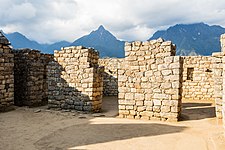
A wall about 400 meters long divides the city from the agricultural area. Parallel to the wall runs a "moat" used as the main drainage of the city. At the top of the wall is the door of Machu Picchu, which had an internal closing mechanism. The urban area has been divided by current archaeologists into groups of buildings named by a number between 1 and 18. The scheme proposed by Chávez Ballón in 1961 that divides it into a hanan sector is still valid. (high) and another hurin (low) in accordance with the traditional bipartition of society and the Andean hierarchy. The physical axis of this division is an elongated plaza, built on terraces at different levels according to the slope of the mountain.[citation needed]
The second most important axis of the city forms a cross with the previous one, crossing practically the entire width of the ruins from east to west. It consists of two elements: a long, wide staircase that serves as the "main street" and a set of elaborate water fountains that runs parallel to it. At the intersection of both axes are located the residence of the Inca, the temple-observatory of the tower, and the first and most important of the water sources.
Hanan Sector


- Set 1
Set 1 includes structures related to caring for those who entered the city through the gate (a "vestibular area"), stables for camelids, workshops, kitchens, and rooms. All this on the east side of the road, in a succession of parallel streets that go down the slope of the mountain. The most important construction, the vestibular building, had two floors and several entrances. To the left of the entrance path there are rooms of a lower rank that would be related to the work in the quarries, located in the vicinity of this sector. All the constructions are of common rig and many of them were plastered and painted.
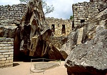
- Temple of the Sun
It is accessed through a doorway with a double jamb, which remained closed (there are remains of a security mechanism). The main building is known as "Torreón", made of finely carved blocks. It was used for ceremonies related to the June solstice. One of its windows shows traces of having embedded ornaments that were torn off at some point in the history of Machu Picchu, destroying part of its structure. In addition, there are traces of a large fire in the place. The Torreón is built on a large rock below which is a small cave that has been completely lined with fine masonry. It is believed that it was a mausoleum and that mummies rested in its large niches. Lumbreras even speculates that there are indications to affirm that it could be Pachacútec's mausoleum and that his mummy was here until shortly after the Spanish invasion of Cuzco.
- Real residence
Of the constructions intended for housing, this is the finest, largest and best distributed in Machu Picchu. Its access door leads to the first fountain of the city and, crossing the "street" formed by the great staircase, to the Temple of the Sun. It includes two rooms with large monolithic lintels and well-carved stone walls. One of those rooms has access to a service room with a drainage channel. The set includes a pen for camelids and a private terrace overlooking the eastern side of the city.
- Sacred square
This is the name given to a set of buildings arranged around a square patio. All the evidence indicates that the place was used for different rituals. It includes two of the best buildings in Machu Picchu, which are made of large carved rocks: the Temple of the Three Windows, whose walls of large polygonal blocks were assembled like a puzzle, and the Main Temple, made of more regular blocks, which it is believed that it was the main ceremonial site of the city. Attached to the latter is the so-called "house of the priest" or "chamber of ornaments". There are indications that suggest that the general set was not finished being built.
- Pyramid Intihuatana
It is a hill whose flanks were turned into terraces, taking the shape of a great pyramid with a polygonal base. It includes two long access stairs, to the north and to the south, the latter being especially interesting for being carved out of a single rock for a long stretch. At the top, surrounded by elite buildings, is the Intihuatana stone ('where the Sun is tied'), one of the most studied objects of Machu Picchu, which has been related to a series of places considered sacred, from which clear alignments are established between astronomical events and the surrounding mountains.
Hurin Sector
- Sacred rock
This is the name given to a flat-faced stone placed on a wide pedestal. It is a milestone that marks the northern end of the city and is the starting point of the path to Huayna Picchu.
- Group of three covers
It is a large architectural ensemble dominated by three large kanchas arranged symmetrically and interconnected. Its covers, of identical invoice, face the main square of Machu Picchu. Includes homes and workshops.
- Group of mortars or acllahuasi
It is the largest complex in the city, despite which it had only one entrance door, something that could suggest that it was the Acllahuasi (or 'house of chosen women') of Machu Picchu, dedicated to religious service and fine crafts. It includes a famous well-hewn stone room on the floor of which are two rock outcroppings carved into the shape of circular mortars, supposedly for grinding grain. Some authors think that these were filled with water and the stars were reflected in them. The set includes evidence of ritual use; there are altars and even a court built around a large rock. Part of its environments show evidence of having been elite residences.
- Condor Group
It is a wide set of constructions, not always regular in outline, which takes advantage of the contours of the rocks. It includes some caves with evidence of ritual use and a large carved stone in the center of a large patio in which many believe they see the representation of a condor. To the south of the "condor" are elite dwellings, which had the only private access to one of the sources of Machu Picchu. Between the houses and the courtyard of the condor, clear remains of constructions dedicated to raising guinea pigs (Cavia porcellus) have been identified.
- Staircase of sources
It is a complex formed by a large staircase next to which runs a system of 16 artificial waterfalls, most of which are carefully carved in polygonal blocks and surrounded by gutters carved into the rock. The water comes from a spring on the heights of the Machu Picchu hill that was channeled in times of the Empire. An additional system at the top of the mountain collects rainwater seepage from the mountain and diverts it into the main channel.
Quarry area
In the upper part, immediately after entering through the main street, there are six rooms, connected by a staircase. These are rustic constructions that surely served as a home for the guardians of the main gate, as well as stonemasons, carvers and stone workers, since the quarry is very close to this grouping.
In archaeological excavations carried out, pots, plates, aríbalos for water, wells, a stone mill and burned earth have been found; from these it can be deduced that it was cooked for a large number of people and chicha was prepared (excavations by Julinho Zapara). Also in relation to this area, a number of tools and very hard stones were found.
This area of quarries shows a diversity of carved or semi-carved rocks, with cuts for construction, among which canals, inlets and outlets, half-cut rocks and ramps to mobilize them stand out. The enclosures of this area are directly related to the suppliers of construction material for the different zones or groups of the city of Machu Picchu.
Originally the entire area where the city of Machu Picchu was settled was a large quarry that geologists call “the granite chaos”. The rocks, which were transformed into lithic polyhedrons and transported to work, are of different qualities. There they received the finish and the final carving. The polishing would be done after being placed on the wall; for example, in the temple of animals.
As a curious detail, it should be noted that there is a stone with indentations or cracks made to extract new stones during some of the restorations. Some ill-informed guides often show it, stating that wet logs were placed in the grooves that, when expanded, produced the fracture. Such an explanation is only possible in the imagination.
Constructive aspects
Hydraulic and soil engineering
A stone city built on top of an "isthmus" between two mountains and between two geological faults, in a region subjected to constant earthquakes and, above all, copious rains all year round is a challenge for any builder: prevent the whole complex from falling apart. According to Alfredo Valencia and Keneth Wright "the secret of Machu Picchu's longevity is its drainage system". Indeed, the floor of its uncovered areas is provided with a drainage system consisting of layers of gravel (crushed stones) and rocks to avoid the ponding of rainwater. 129 drainage channels extend throughout the urban area, designed to prevent splashing and erosion, flowing mostly into the "moat" that separates the urban from the agricultural area, which was actually the main drainage of the city. It is estimated that sixty percent of the construction effort of Machu Picchu was in making the foundations on terraces filled with gravel for a good drainage of excess water.
Orientation of buildings
There is solid evidence that the builders took into account astronomical and ritual criteria for construction, according to studies by Dearborn, White, Thomson and Reinhard, among others. Indeed, the alignment of some important buildings coincides with the solar azimuth during the solstices in a constant and therefore not casual manner, with the rising and setting points of the sun at certain times of the year and with the summits of the surrounding mountains.
Architecture

- Materials
- All the preserved constructions are of white granite, composed of 60% by feldespato, 30% quartz and 10% mica. All the material came from the quarries located in the contours of the incaic complex.
- The rock has between 6 and 7 degrees of hardness on the Mohs scale. In the Empire this was worked with bars and other bronze tools (no iron tools were used in ancient Peru) and more hard rock percutors. The rocks were smoothed by sand abrasion.
- Morphology
- Almost all the buildings are rectangular. There are one, two and up to eight doors, usually on one of the long sides of the rectangle. There are few curved and circular constructions.
- The buildings called Huayran. These have only three walls. In these cases, in the space of the "muro lacking" sometimes appears a stone column to hold a wooden beam that served as a support to the ceiling. They also exist Huayran double, two Huayran united by a medium wall, to which it is called More.
- The buildings usually follow the scheme of the Kanchas; i.e., four rectangular constructions arranged around a central courtyard coupled with a transversal symmetry axis. To this courtyard they give all the doors.
- Muros
The rigging of the stone walls was basically of two types.
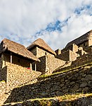
- Of ordinary stone joined with clay mortar and other substances. There is evidence that these constructions, which are a majority in Machu Picchu, were lit with a clay layer and painted (in yellow and red colors at least), although the early disintegration of the ceilings made them vulnerable to the permanent rain of the area and therefore have not been preserved.
- Finely carved stone in elite buildings. They are granite blocks, without glazed and perfectly carved in the form of rectangular prisms (paralepiped, like bricks) or polygonal. Their external faces could be paddled, that is, protuberating, or perfectly smooth. In these cases the union of the blocks seems perfect and has made to assume that it does not have any kind of mortar; but in fact it does have it: it is a thin layer of agglutinating material that is between stone and stone, although it is invisible on the outside. The effort of these realizations in a society without iron tools (they only knew bronze, much softer) is remarkable.
- Coverage
No original roof has been preserved, but there is a consensus that most of the buildings had a gabled or hipped roof; there was even a conical roof over the "keep", and it was formed by a framework of alder logs (Alnus acuminata) tied together and covered by layers of ichu (Stipa ichu). The fragility of this type of thatch and the copious rainfall in the region made it necessary for these roofs to have large inclinations of up to 63º. Thus, the height of the roofs was many times twice the height of the rest of the building.
- Covers, windows and stoves
- As it is classic in the incaic architecture, most of the covers, windows and bakeracinas (called false windows, niches or alacenas) have trapezoidal shape, wider on the base than on the lintel. Dintils could be made of wood or stone (often of a single large block). The covers of the most important enclosures were double ham and in some cases included an internal closure mechanism.
- The interior walls of much of the buildings have pancakes in a trapezoidal form, next to the windows. Cylindrical or rectangular blocks often stand out from the walls as large racks, arranged in symmetrical form with the hornacinas or niches and the windows, when there are.
Surroundings and Inca roads

Machu Picchu, as an integral part of a region of great economic movement in the time of Pachacútec, was integrated into the Inca road network of the Empire. Using these routes it is possible, until today, to access other nearby Inca complexes that are of great interest. To the north, through the forks in the Huayna Picchu road, you can reach the so-called Temple of the Moon or the top of the mountain where there are Inca constructions. To the west is the road that leads to Intipata and passes over the famous drawbridge. Another path, by which Agustín Lizárraga ascended, leads to the river and San Miguel.[citation required]
To the south, however, is the best known and the main route of all, which is the most popular hiking route in Peru. The Inca Trail to Machu Picchu is a three to four day trek through what, at the end of the 15th century, It was the main access route to Machu Picchu, which began at the Llactapata complex and passed through the ceremonial centers of Sayacmarca, Phuyupatamarca and Huiñay Huayna, ending at the Intipunku tambo, the "garita" entrance to the domains of Machu Picchu and final point of the tour.[citation required]
Miscellaneous
- Hiram Bingham took 5000 archaeological pieces to Yale University, product of excavations in Machu Picchu. For a long time they were claimed by the Peruvian government until an agreement was reached in 2007. His return was expected at the end of 2009, however, it was not given. The University of Yale recently confirmed the return of the pieces in 2011, commemorating the centenary of the Machu Picchu rediscovery by Bingham.
- In May 2005, the former Jordanian city of Petra was "sister" with that of Machu Picchu.
- Gloria Estefan recorded on this llacta Incaica the video clip of his song "Today" composed by the Peruvian Gian Marco.
- The Chilean musical group Los Jaivas immortalizes the poem by Pablo Neruda Alturas de Machu Picchu filming a clip of the songs of the homonymous album on Machu Picchu in 1980. This album is considered one of the best albums in Chilean music.
- In a comic by Superman, Machu Picchu appears in a scene where Superman is reflecting, then a battle begins, where one of the walls is destroyed.
- It is common to spread among tourists that "if you look at it side you can appreciate the face of a man" (many times referred to as an inca).
- Machu Picchu gives its name to the Peruvian base of scientific research located on the island Rey Jorge, in the Antarctic.
- In 1971, Werner Herzog wheel on Machu Picchu the spectacular boot scene of his feature film Aguirre, the wrath of God.
- In the summer of 2009 one of the mythical sequences of the documentary feature film was filmed in the citadel Quantum Men, directed by Carlos Serrano Azcona and starring Cristóbal Jodorowsky.
- At Top Gear (videogame) and Top Gear 2 of the SNES console, one of the circuits is Machu Picchu at the South America (South America) level.
New wonder of the world
On July 7, 2007, Machu Picchu was chosen as one of the new seven wonders of the modern world, a private initiative of the New Open World Corporation (NOWC), created by the Swiss Bernard Weber, without needing the endorsement of no institution or government to continue with its electoral purposes and allow the selection of wonders classified by the vote of more than one hundred million voters. This vote was supported by the government of Alan García Pérez, through the Ministry of Foreign Affairs and that of the Tourism sector; This diffusion had its fruits in a great participation of the Peruvian people as a whole and also in the international arena. When the results were known, President Alan García declared by supreme decree, July 7 as "Day of the Historic Sanctuary of Machu Picchu", to remember the importance of the sanctuary for the world, recognize the participation of the Peruvian people in voting and promote tourism.
The New Seven Wonders of the Modern World were chosen by popular vote based on aesthetic, economic, tourist and recreational criteria rather than for their historical importance or artistic merit, which is why they do not have the backing of institutions such as UNESCO. No However, the distinction has great echo, which derives in an important supplementary claim for attracting tourism. In fact, Machu Picchu is today the main tourist destination in Peru with 600,000 visitors/year (according to MINCETUR) and one of the most desired by travelers from all over the world.
Cinema
- The Paramount Pictures Film Secret of the Incas (1955), with Charlton Heston and Yma Súmac, was filmed in locations in Cusco and Machu Picchu, the first time a major Hollywood studio filmed in the place. Five hundred indigenous people were hired as extras in the film.
- The opening sequence of the film Aguirre, the wrath of God (1972) was shot in the Machu Picchu area and in the Huayna Picchu stone staircase.
- Machu Picchu was featured in the film Motorcycle Journals (2004), a biographical film based on the 1952 youth travel memories of the revolutionary Marxist Che Guevara.
- NOVA TV documentary Ghosts of Machu Picchu presents an elaborate documentary on the mysteries of Machu Picchu.
- The contemporary multimedia artist Kimsooja used Macchu Picchu as the main stage for the first episode of her series of Thread Routes films, filmed in 2010.
- In 2019, the film Godzilla: King of the Monsters mentions the citadel of Machu Picchu, as one of the locations where the Titan Quetzalcóatl remains hidden.
Theater
- Machupikchu's dream, of Millán Picouto, third tragedy, in an act and in verse, of the "Incaic Trilogy", included in the volume of his complete works "The macrocosmos," Editions Linteo, 2021. ISBN 978-84-123801-0-1
Music
The song "Kilimanjaro", from the South Indian film Tamil Enthiran (2010), was filmed at Machu Picchu. The sanction for the shooting was given only after the direct intervention of the Indian government.
Gallery

General view.
Superior general view.

Dawn from Inti Punku, on the final stretch of the Incaic Way of the south of the city.

Details of a trapezoid window, possibly lighted and painted.
Cocks or deposits on the platforms of the agricultural sector.
The so-called Condor Stone on the 17th.

Inca weather.

Terraces.
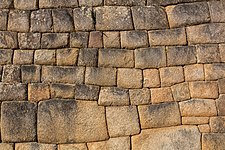
Detail of the wall mat.

Calls on Machu Picchu.
Residential area.

Acantied.


Panoramic views


Contenido relacionado
196
Moment
France