Livestock track
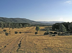
The livestock roads or "cabañeras" They are transhumance paths that connect the traditional grazing places in Spain so that shepherds and ranchers can take goats, sheep and cattle to the best pastures, taking advantage of the good weather: to the ports or high mountain pasture areas in summer. or to flatter areas with a more temperate climate in extreme winters. The cattle routes differ from each other and acquire their name according to their width. In addition, the cattle trails are great biological sources since various types of vegetation grow on them and are the habitat of different animal species. On the other hand, they are communication channels, flat and straight routes that are nestled between the mountains facilitating the passage between populations since they are the shortest and easiest paths to travel.
The cattle tracks represent some 125,000 km of routes for transhumance in Spain, 1% of its territory, some 450,000 hectares. Legally, in Spain, cattle trails are public domain property whose ownership is exercised by the autonomous communities, this legal protection being what makes them unique in Europe.
Its basic legal regime in Spain is currently regulated by Law 3/95 on livestock routes, which defines livestock routes as routes or itineraries along which livestock transit runs or has traditionally taken place. Livestock traffic associated with livestock roads can be:
- Estante or local, used by communal cabins that do not leave the municipality.
- Transtermining, the herds transfer -transterminan-the jurisdictional term of their municipalities and go on to use dehesas of neighboring villages.They are usually less than 100 km.
- Trashumante, that of the large semi-annual displacements, where the huts in winter, due to the cold and snow that reduces the surface of the pastures in the north, are directed to the greenhouses of the South of Castilla, Andalusia, Extremadura, Valle del Ebro and Levante. In summer, they take the road back to the mountains of the north of Spain.
In article 3.1.d of Law 3/1995 on the actions of the autonomous communities there is one of the purposes set out by said law: To ensure the proper conservation of livestock routes, as well as other environmental or cultural elements valuable, directly linked to them, by adopting the necessary protection and restoration measures.
However, on many occasions the legal scope is not respected and the cattle tracks become paved or urbanized roads. Among the environmental consequences that occur when urbanizing a cattle route are the increase in intentional fires, the loss of vegetation and biodiversity, the appearance of improvised landfills, the contamination of the subsoil with domestic water and the loss of a public patrimony that passes illegally to a few people. The cattle routes in the areas of urban growth of the cities and towns are in the process of disappearing, unless strong legal measures are taken to prevent it.
This is the case presented in 2005 by the association El Taller Verde de Marchena, in Seville. In their newsletter, JARDA, they publicized the problem of the Cañada Real de Pruna, an example of occupation and contamination of a cattle route, described by them as an "attack on the environment".
Another example of disrespect for the environment is the one denounced in 2003 by Izquierda Unida together with Ecologistas en Acción for having paved several kilometers of a cattle track in the Toledo municipality of Illescas.
Types of livestock trails
Cañadas, cordeles, paths, resting places, sheepfolds, drinking troughs and counting holes are part of the intricate system that forms the cattle tracks, with different and numerous local names.
Depending on the place where they are located, the cañadas reales have different denominations. For example, in Andalusia they are known as veredas de carne; in Aragon they are cabañeras; in Catalonia, carreradas and in Castile, they are called cordones, cuerdas, galianas or cabañíles, depending on their size.
In Spain, the network of cañadas reales is 125,000 km long (comparatively, the railway is 15,000) and covers 425,000 ha. In the whole of Europe, more than 4 million hectares of pastures and agricultural land are associated with transhumance.
Ends of the cattle trails
The cattle roads currently serve not only the transit of livestock but also other purposes worthy of protection.
- AGROPULATIONS
- Livestock transit. (They must be free and expedited) - Agricultural communications.
- MEASURES
- Promote biodiversity. - Genetic exchange of fauna and flora species. - Territorial mobility of wildlife. - Improvement and diversification of the rural landscape.
- PUBLICS
- Public use. - Compatible activities (citizen recreation, hiking, cycling, horseback riding, etc.).
Royal glens
Of the nine most important royal glens, the so-called eastern Soriana is the longest. It starts north of La Soria, in Yanguas, crosses the province of Ciudad Real, and ends in the land of Seville, after traveling about 800 km.
Dimensions of the cattle trails
From a legal point of view, the width, layout, existence and name of a cattle route is made in the administrative act of classification. The margins that limit the cattle trails are legally established in the administrative demarcation procedure, and their materialization on the ground, by means of permanent milestones (cairn), is carried out in the administrative act of demarcation.
Legal Width
The Civil Code and Law 3/1995 define the name and maximum width that a cattle track can have. In some sections it may have greater widths as a consequence of the existence of other attached livestock areas (for example, resting places, drinking troughs), in other cases it may have smaller widths as a consequence of its administrative life.
- Cañada: that road whose width does not exceed 75 meters.
- Cordel: when its width does not exceed 37,50 meters.
- Vereda: the paths whose width is not greater than 20 meters.
- Colada: its width is determined in the act of the classification.
These are the legal widths at present, although until Law 22/1974 their widths were somewhat greater when referring to their equivalence with the Castilian rods (75.22, 37.71 and 20.89 m respectively). In the 18th century, the Vereda Mayor del Valle de Alcudia (Cañada Real Soriana Oriental) reached a width of between 300 and 800 m at its entrance to the valley.
The traditional name of "Cañada Real" to the current Cañada comes from the times of Alfonso XI who, due to the importance of the cattle roads at that time for the wool business, placed them under royal protection, a process that continued with Enrique IV who in a Royal Charter places the main cattle routes under its direct domain.
Additional elements
In addition to the livestock trails themselves, there were some additional elements that completed and assisted this network of livestock trails:
- Restores: widening the road where the flocks could rest or spend the night.
- Abbreds: they could be wells with pylons or coincide with the passage of streams, rivers or lagoons.
- Majadas: where the flocks spent the night.
- Mojones or milestones: signaling the itinerary of the roadways.
- Real ports: places where taxes were charged to the crown.
- Accountants: narrow steps where you can easily count cattle heads. They could be bridges or narrowings of the road.
- Bridges: some of them served as containers.
- Choices: homes of the transhumante shepherds during their stay in the “extreme”.
- Esquileo houses
- Washing machines
- Livestock societies
- Ermitas mesteñas
- Transhumanity sales.
- Carteles indicators of livestock.
Roads by region
Extremadura
- The Royal West Lioness Cañada: unites the extreme foothills of Sierra Morena (Badajoz) with the north of León.
- The Royal Oriental Lions Cañada: the southern border of Extremadura (Badajoz) with the Riaño and the ports of the High Esla.
- La Cañada Real Burgalesa: une las dehesas del suroeste de la provincia de Cáceres con la Sierra de la Demanda, entre Burgos y La Rioja.
- La Cañada Real Soriana Occidental: une tierras oliventinas de Valverde de Leganés (Badajoz) con los pastos del Burgo de Osma y de los Cameros.
- La Cañada Real de la Plata (de la Vizana or Zamorana): unites the city of Trujillo (provincia de Cáceres) with the pastures of the region of Babia, in the Leon ports.
- La Cañada Real Segoviana: une Granja de Torrehermosa y La Serena (Badajoz) con las sierras burgalesas.
Community of Madrid
Law 8/1998, of June 15, on livestock routes of the Community of Madrid (B.O.C.M. of June 23, 1998), defines the regulatory and planning instruments that allow rational management of this historical legacy.
The Royal Cañadas that run through the Community of Madrid are:
- Cañada Real Leonesa Oriental
- Cañada Real Segoviana
- Cañada Real Galiana
- Cañada Real Soriana Oriental
Andalusia
After the 1978 Constitution came into force, the cattle routes appear in the Statutes of Autonomy. Specifically, in article 13.7 of the one approved in Andalusia, the Autonomous Community is attributed exclusive competence in this matter. (Today, in article 57.1.b of the current Statute, approved by L.O. 2/2007).
Based on this power and the regulatory framework generated after the entry into force of Law 3/1995, Decree 155/1998 is approved, approving the Regulations for Livestock Routes of Andalusia. These two norms, together with the Heritage Law, of supplementary application, are the essential legal basis in the management of livestock heritage.
The Autonomous Community of Andalusia, in the process of recovery and protection of the public patrimony, which presides over the State Law of cattle roads, has tried to prioritize and rationalize the work. To this end, the Plan for the Management and Recovery of the Andalusian Livestock Trails was drawn up, approved by the Governing Council on March 27, 2001, published in BOJA No. 74, on June 30.
Andalusia has a network of livestock roads of approximately 30,000 km, which represents 25% of the total national network. Until the approval of the aforementioned Management and Recovery Plan, these livestock routes had been managed at the request of the different Administrations and administered. What is intended is to prioritize and rationalize a very extensive work that began with the aforementioned Plan. The cattle routes have been catalogued, setting priority levels and assigning them some uses, which direct the Ministry of the Environment itself in the different actions to be undertaken and that can set the criteria when deciding whether we are facing an inalienable cattle route or not.
Competencies over livestock routes in Andalusia are attached to the Ministry of the Environment of the Junta de Andalucía.
Contenido relacionado
Zamayon
Martin de Yeltes
Vermont


