
Lisbon Region
The Lisbon region, also known as Estremadura, is a region in the center-west of Portugal, where Lisbon is located.
It forms a peninsula west of the Tagus estuary. It limits to the north with the Beira Litoral, to the east with the Ribatejo and to the Southeast with the Alentejo.
Place name
About the origins of the name of Estremadura there are several hypotheses:
- The name of Estremadura Latin drift Extreme Dorii('Extremos del Duero', or rather 'on the other end' of the Duero, referring to its position south of this river), with which the territories located south of the Duero River basin (and its tributaries) were designated.
- Today, however, the thesis that the vocablo Estremadura was used, in general, during the Reconquest to name the lands located in the "extreme", the border, of the Christian kingdoms of the north (in particular, of the kingdoms of Leon and Castile) with Al-Andalus. Thus, Extremadura is the name that the lands of the border of Castile receive, around the present province of Soria (remember that the shield of its capital says Soria pure Estremadura head): it would be about the Extremadura castellana; and Estremadura is the name also given to the territories "extreme", more distant and in the first line of defense against the Islamic enemy during the Reconquest, of the Kingdom of Leon, which would initially occupy much of the present province of Cáceres, to extend to the south after the conquest of the taifa realm of Badajoz: this would be treated, therefore, sensu strictoOf the Extremadura leonesa.
Geography
Municipalities
The Lisbon region includes 31 municipalities:
- Leiria District: Alcobaça, Bombarral, Caldas da Rainha, Marinha Grande, Nazaré, Óbidos, Peniche and Porto de Mós.
- Lisbon District: Alenquer, Amadora, Arruda dos Vinhos, Cadaval, Cascaes, Lisbon, Loures, Lourinhã, Mafra, Odivelas, Oeiras, Sintra, Sobral de Monte Agraço and Torres Vedras.
- Setúbal District: Alcochete, Almada, Barreiro, Moita, Montijo, Palmela, Seixal, Sesimbra and Setúbal.

Lisbon
Setup

Sintra

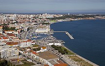
Cascaes

Nazareth
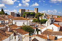
Obidos

Sesimbra
.jpg)

_edited.jpg)
.jpg)
.jpg)


History
In the 15th century, the Portuguese Estremadura roughly corresponded to the districts of Lisbon, Setúbal, Santarém and Leiría.
Throughout history, its boundaries have been frequently altered. In the 19th century, when it ceased to have administrative importance, its limits roughly corresponded to the current districts of Lisbon and Setúbal, and to the southern part of the Leiría district.

In the administrative reform that took place in 1936, a province of Estremadura was created again. However, this new province only covered a part of the territory of the old homonymous region. Part of the territory of the old Estremadura was incorporated into the new provinces of Ribatejo and Beira Litoral. On the other hand, the new Estremadura included part of the current district of Setúbal that had traditionally belonged to the old province of Alentejo.
However, the provinces of 1936 had practically no practical assignment, and they disappeared from the administrative vocabulary (though not from the everyday vocabulary of the Portuguese) with the entry into force of the 1976 Constitution.
Contenido relacionado
Land
Cadiz Province
Albania