Libyan Geography
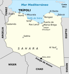
Libya is a country in Mediterranean Africa. Libya borders the Mediterranean Sea to the north, Tunisia and Algeria to the west, Niger to the southwest, Chad to the south, Sudan to the southeast, and Egypt to the east.
The country is characterized by its large expanses of desert (Sahara desert) that cover the entire country except for a narrow coastline that is where the country's main population centers are located (Tripoli, Benghazi...).
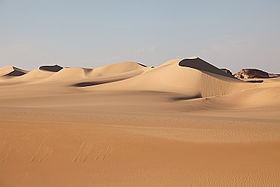
The Libyan Desert, which is framed within the Sahara, occupies the entire south of the country and extends to Egypt and Sudan. It is one of the most inhospitable areas on the planet.
Relief
Libya's two main geographical areas are the Mediterranean coast and the Sahara. In the desert, there are several plateaus but no mountain ranges with the exception of the Tibesti massif, near the border with Chad, in the south.
In Tripolitania, the northwestern region of Libya, there is a coastal plain, Djeffara, which is about 14,300 km². It extends from Gabes, in Tunisia, to about 20 km east of Tripoli. The coastal zone is a narrow strip of sandy beaches with small hollows that fill with water during the rains and form salty plains. It is followed by a steppe area inland that rises from 50 to 200 m, up to about 120 km from the coast, where the foothills of Yebel Nefusa are found, a plateau area with escarpments that culminates at 968 m. In Djeffara, between 125 and 250 mm of rain fall, which increases towards Tripoli, with 380 mm. Date palms grow and there are herds of sheep and goats.
Jebel Nefusa covers more than 10,000 km², is populated by Infusen Berbers and stretches from the Tunisian border to the city of Garian for about 190 km. It then curves into the Mediterranean for another 150 km almost to the coast, at Al-Khums. It is crowned by a plateau about 25 km wide covered with scrub in the north and basalt and lava wastelands in the south. The rains oscillate between 50 and 400 mm. Olive trees, fig trees, tobacco and esparto grass are cultivated for ropes and footwear in addition to the herds.
Behind it is the plateau of Hamadah Al Hamra, a desert region of 84,000 km² that extends to Ghadames in the southwest, near the border with Algeria and Tunisia. It is famous for the meteorite of its name (HaH 280), of carbonaceous chondrite.
To the south of Tripolitania is the region of Fezán, which extends to Chad, where the Tibesti massif is found. A large part of the region is covered by the 50,000 km² Idehan Ubari or Ubari Desert and the 58,000 km² Idehan Murzuq or Murzuq Desert, which are part of the Libya. To the north of Fezan is the Wadi Ashati, which gives its name to the Wadi Al Shatii district and stretches for about 140 km. Fezán was the land of the Garamantes, who crossed the trade routes of the desert in the days of Carthage and Rome.
The Acacus Mountains are southwest of Fezan, about 100 km south of the town of Ghat. In the middle of a landscape of dunes with deep wadis, rocky places emerge that form imposing stone arches (Afzejare and Tin Khlega). These mountains are famous for their cave paintings. This entire southern region is part of the Libyan desert.
The eastern half of Libya is known as Cyrenaica. In its western part, in the center of Libya, to the south of the Gulf of Sirte, is the Haruj or Hulayq al Kabir, a volcanic massif that contains about one hundred and fifty volcanoes, including numerous basaltic scoria cones and about thirty small volcanic fields formed by solidified lava, with a maximum height of 1200 m.
To the east of the Gulf of Sirte, already in Cyrenaica, is the Yebel Ajdar or Green Mountain, about 16 km from the sea, with an altitude of 900 m and a length of about 300 km, up to the Gulf of Bomba. It is one of the few regions of Libya with forests, with a rainfall of 600 mm. The rest of the coast to the east is formed for the most part by an escarpment of about 300 m, with two ports at Bomba and Tobruk. The farther east, towards historic Marmarica, the land is drier.
To the south and east of Jebel Ajdar is Jebel el-Akabah, lower and separated by a depression. The rest of Cyrenaica is formed by the Libyan desert, which extends from Egypt to the Acacus mountains, and is an extension of more than 1 million km², which is about a thousand kilometers on each side, made up of plains, dunes, mountain ranges and some depressions, but no river. On the border with Egypt and Sudan is the Jebel Uweinat, which rises above 1900 m. The most important oases are Al Jaghbub and Jalo, in the east, and Kufra and Murzuk, in Fezán. The seas of sand form a ring around the desert. The aforementioned Idehan Ubari and Idehan Murzuq are joined by the 72,000 km² Great Sand Sea, which it shares with Egypt, the 65,000 km² Rebiana Sand Sea, and the 62,000-km² Calanshio Sand Sea. km².
Fertile lands are found on the coast and in the mountains immediately behind, both in Tripolitania and Cyrenaica, separated by the Gulf of Sirte, which traditionally separates the Maghreb from the Mashreq.
The border between Tripolitania and Tunisia is subject to continuous crossings by legal and illegal migrants. No natural border marks the border, and the ethnic composition, language and culture of the two peoples are almost identical. The same happens between Cyrenaica and Egypt. By contrast, the border with Algeria, Niger and Chad is rarely crossed due to the emptiness of the vast desert. On the border with Chad is the Aouzou strip, the two countries fought over each other for many years.
Climate
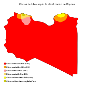
There are no permanent rivers in Libya due to low rainfall. The dominant climate is that of a hot desert with long suffocating days and somewhat cooler nights in the higher areas. Less than 2 percent of the territory receives enough rain to cultivate the land. Only in Cyrenaica, in the Jebel Ajdar, they fall between 400 and 600 mm (Al Baida, 540 mm); the rest of the coast receives between 200 and 350 mm, in the Gulf of Sirte between 100 and 200 mm fall, and to the east, near Egypt, less than 100 mm. The coastal rains are due to the passage of depressions through the Mediterranean Sea, likewise, the sea breeze cools the temperature. In Tripoli, the wettest city, 335 mm fall in 52 days, almost all between October and May; in summer, temperatures are bearable, between 20.oC and just over 30.oC. In winter, between 9 and 19.oC. In Benghazi they fall 260 mm and in Misrata, near the Gulf of Sirte, 180 mm. In Tobruk, to the east, they fall between 94 and 110 mm.
Insides, temperatures rise to 35-37.oC in areas close to the coast, and exceed 40.oC in the south. In the Nefusa Mountains, at almost 1000 m in Nalut, Zintan, Lefren and Garian, winters can be cold. Libya suffers the effects of a wind called ghibli, dry and hot, which causes humidity to drop and temperatures to rise suddenly, between April and October, even on the coast, where temperatures can reach 30.oC in winter.
In the great Sahara desert, less than 50mm falls. In summer, temperatures can exceed 50oC. The rains are rare, and there is hardly any population except in the oases. In Sabha, in Fezzan, at 400 m elevation, temperatures range from 24 to 39 between June and August. oC, and in winter, between 6 and 20.oC.
Hydrography
There are no permanent rivers in Libya. There are numerous dry wadis or rivers that cause flash floods when it rains but dry up quickly. The most important are Wadi Zamzam and Wadi Bayy al-Kabīr. Both flow into the eastern coast of the Gulf of Sirte. There are other important wadis in the area of the Zaltan oil field, 150 km south of the port of Marsa Brega, in the Gulf of Sirte, and in Fezzan.
In Libya there are numerous fossil aquifers in Fezzan and the southeast of the country, as well as wells and springs. In Gadaffi's time, the so-called Great Man-made River was built, a network of pipes that supply water to the Sahara desert from fossil aquifers, mainly the Nubian sandstone aquifer system. It consists of more than 1,300 wells, most of them more than 500 meters deep, and provides 6,500,000 m³ (6.5 hm³) of fresh water per day to the cities of Tripoli, Benghazi, Sirte and others, which previously They were dependent on desalination.
The Nubian Reservoir is between 10,000 and 1 million years old and is made up of water that seeped through the desert sands. It was discovered in the late 1950s while searching for oil. It has between 100,000 and 150,000 km³ of groundwater. The Great Artificial River project has several phases. The westernmost, near Tunis, draws water from wells near Ghadames and delivers it to the coastal cities of Zaouiya and Zuara, west of Tripoli. The easternmost one, near Egypt, carries water from the Al Jaghbub depression to Tobruk, in the east of the country. The system is prepared to carry 6.5 million m³ of water per day along 4,000 km of pipes, assembled using 7 m long and 4 m high concrete pieces, and from as far away as Jabal Hasouna, in Fezzan, and Kufra and Tazerbo, in the southeast of the country. One project would link cities on the coast. Open water distributors have been built in the system, forming lakes of more than 1 km in diameter, such as in Ajdabiya.
In the western coastal plains, there are several salt lakes or sebkhas, which are formed by evaporation of water that forms in the hollows in the rainy season.
Libya Protected Areas
Since 2012, large areas of Libya have been temporarily closed due to the war situation in the country, specifically the borders with Sudan, Chad, Niger and Algeria. Ghadamés, Ghat, Obari, Al-Shati, Sebha, Murzuq and Kufra military zones have been declared, so that in this precarious context, national parks and natural areas of interest lack protection. In 2014, two rival parliaments were fighting over the country; to them was added the Islamic State, which occupied an area around the Gulf of Sirte, and in 2016 a fourth contender, the Government of National Accord (GNA), was added.
In Libya there were, as of February 2018, 3,437 km² of protected land, 0.21% of the territory, and 2,278 km² of marine surface, 0.64% of the 357,895 km² of total marine area belonging to the country. In that extension, there are 4 national parks (previously there were 7), 4 nature reserves (there were 5) and 14 protected areas (there were 24), in addition to 2 Ramsar sites, Ain Elshakika (33 ha) and Ain Elzarga (50 ha). There were also 5 archaeological sites considered World Heritage Sites: Cyrene, Leptis Magna, Sabratha, Ghadamés and Tadrart Acacus.
- El Kouf National Park, 320 km2, east of the Ajdar yebel, on the coast, near the Wadi el Kuf bridge, the second highest bridge in Africa. There are hyenas, Egyptian wolves, African or desert wild cats, puercos crested spins, the monkeys of Gibraltar, and at sea, the common dolphin, the mular dolphin and the boba turtle, among others. In vegetation, next to the dunes extends the maquis, with Atlas cedars, acebuches, myth, lentisco, juniper, etc.
- El Nagazza National Park, 4,000 km2
- Ramja National Park
- Karabolli National Park, 150 km2
- Bengasi Nature Reserve, 0.5 km2
- Bier Ayyad Nature Reserve, 20 km2
- Zellaf Nature Reserve, 1000 km2
- Tripoli Nature Reserve, 8.7 km2
Contenido relacionado
Department of Moquegua
Maine
Iowa


