Latitude
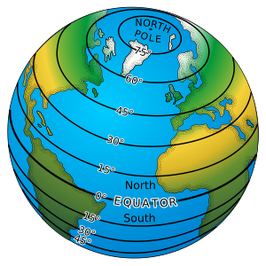
Latitude is the angular distance between the equatorial line (the equator) and a given point on Earth, measured along the meridian on which that point lies. Depending on the hemisphere in which the point is located, it can be north or south latitude.
Latitude provides the location of a place, in a North or South direction from the equator and is expressed in angular measures that vary from 0° of the Equator to 90° N of the North Pole or 90° S of the South Pole. This suggests that if we draw a line that goes from any point on the Earth to its center, the angle that this line forms with the equatorial plane expresses the latitude of said point. The North or South orientation depends on whether the marked point is closer to the North Pole than to the South Pole (northern latitude) or closer to the South Pole than to the North Pole (south latitude).
Latitude is measured in sexagesimal degrees (represented by the symbol degrees ° immediately above and to the right of the number, while subdivisions or fractions of degrees are represented by ' which stands for sexagesimal minute and '' which means second sexagesimal), between 0° and 90°; and can be represented in two ways:
- Indicating to which hemisphere the coordinate belongs, writing N or S after the degree symbol and separated from it by a space.
- Adding positive values, that is, with a more (+) or customary sign without any sign before the number—in the north—and negative, with a less (–) sign before the number—in the south.
Thus, ten degrees north latitude could be represented 10° N or +10°; and ten degrees south could be 10° S or -10°.
In usual cartography —for example— the sequence –70°55'59” means a latitude (sexagesimal) of 70 degrees, 55 minutes and 59 seconds south latitude (a parallel which would already be in Antarctica).
In maritime navigation, latitude is usually represented by the Greek letter φ (Phi).
If you want to know the distance represented by one degree of latitude, you must consider that the degrees of latitude are regularly spaced. However, the slight flattening of the Earth at the poles causes one degree of latitude to vary from 110.57 km at the equator to 111.70 km at the poles. One degree of latitude is usually rounded to 111.12 km, thus one minute of latitude is 1852 meters (equivalent to one nautical mile) and one second of latitude is 30.86 meters.
Latitudinal zones
The Earth is divided into three large latitudinal zones:
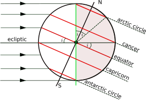
- Intertropical zone: Also called a warm, arid or tropical zone, is the one between the Tropic of Cancer and the Tropic of Capricorn (between latitudes 23°N and 23°S). Predominates tropical climate and forest, savannah and desert ecosystems.
- Tempered area: It is between the tropics and the polar circles. Predominates temperate climate but also subtropical and subpolar climates. Large forests, grasslands and deserts are common.
- Polar zone: Or cold zone, are the areas delimited by the Arctic and Antarctic polar circle, of cold climate and where the large layers of ice and tundra are located between 66° and 90° latitude.
Related expressions
- Latitude of estimation or Estimated: formerly, immediately deducting from the account or calculating the estimate.
- Latitude observed: it was the one obtained by the observation of the stars. When he had differences with that of esteem and this was amended with the correction of such differences, it was also called corrected latitude.
- Latitude marked or marking: which results from markings made at points of the coast.
- Latitude output: that of the point where the ship has departed at the beginning of its navigation or that of that in which a new account of estimation begins, as for example, that of situation at the previous noon.
- Latitude of arrival: that of the point to which a boat has arrived at the end of a synopsis or when the estimate account is closed to know the situation at the time you want or import.
- Average: the one produced by the semisuma of the exit and the arrival. It serves to deduce the length by the detachment of meridian.
- Growing latitude: represented in the increased degrees of the latitude trunk of the spherical chart.
- High latitudes: those that approach the pole more than the equator or pass from the forty-five degrees or half of the quadrant.
- Low latitudes: the most immediate ones to the equator or descend from half the quadrant, and even the third.
- Ascender, climb, mount or go back, rise, win, grow and increase in latitude: sail or advance in distance from the equator to the poles; what also express the phrases win north or Southin their cases; and the inverses of all these verbs would also mean the opposite, that is, to sail or to gain distance from the poles to the equator.
- Running in latitude: navigate a meridian from the equator to the poles. Others understand it by just browsing the meridian in any way.
- Refer to latitude, this is, the difference in latitude, to the point out or another determined. Take that point by reference.
Astronomical latitude
Astronomical latitude (Φ) is the angle between the equatorial plane and the true vertical direction at a point on the surface. The true vertical, the direction of a plumb bob, is also the direction of gravity (the resultant of gravitational acceleration (based on mass) and centrifugal acceleration) at that latitude. Astronomical latitude is calculated from the angles measured between the zenith and the stars whose declination is known with precision.
In general, the true vertical at a point on the surface does not exactly coincide with either the normal of the reference ellipsoid or the normal of the geoid. The angle between the astronomical and geodesic normals is called the vertical deviation and is usually a few seconds of arc, but it is important in geodesy. The reason it differs from the normal to the geoid is that the geoid is an idealized and theoretical shape. "at mean sea level". Points on the actual surface of the Earth are usually above or below this idealized surface of the geoid and in this case the true vertical may vary slightly. Furthermore, the actual vertical at a point at a given time is influenced by tidal forces, which are averaged by the theoretical geoid.
Astronomical latitude should not be confused with declination, the coordinate that astronomers similarly use to specify the angular position of stars north/south of the celestial equator (see equatorial coordinates), nor with ecliptic latitude, the coordinate that astronomers use to specify the angular position of stars north/south of the ecliptic.
Contenido relacionado
Biogeography
Lime
France


