
Lake Toba
Lake Toba (Indonesian: Danau Toba) is a large lake of volcanic origin, 100 km long and 30 km wide, located in the center of the northern part of the Indonesian island of Sumatra. It is the largest lake in Indonesia and the largest crater lake in the world.
Lake Toba was formed by a massive supervolcanic eruption with a Volcanic Explosivity Index VEI 8, which occurred 69,000 to 77,000 years ago, causing significant climate change. It was the largest known explosive eruption on Earth in the last 25 million years. According to the Toba catastrophe theory, this volcanic event had global consequences for human populations and could have caused the death of most of the humans who lived at this time, creating a population bottleneck in the central west of Africa and India, which could have affected the genetic makeup of the world's human population up to the present. However, this hypothesis is not widely accepted because there is no evidence that there was a decline or extinction of other animals during this time, including species that are sensitive to changes in the environment. What is widely accepted is that the Toba eruption led to a volcanic winter after a decrease in global temperature of 3 to 5 °C, and up to 15 °C in higher latitudes. tall. Additional studies, carried out at Lake Malawi in East Africa, show significant deposits of ash from the Toba eruption, even at such a great distance, but there is little evidence to point to a significant climatic effect at the time of the Toba eruption. East Africa.
Geology
The Toba caldera complex comprises four overlapping volcanic craters that join the "volcanic axis" from Sumatran. The most recent of the four measures 100 by 30 km and is the largest Quaternary caldera in the world; it forms the intersection of the three oldest calderas. An estimated 2,800 km³ of dense rock-equivalent pyroclastic material, known as volcanic tuff, was ejected during one of the largest explosive volcanic eruptions in recent geological history. After the eruption, a resurgent dome formed within the new caldera, joining two half-domes separated by a longitudinal graben.
At least four stratovolcanoes are visible in the lake, as well as four cones, and three craters. The Tandukbenua cone, found at the northwestern edge of the caldera, is sparsely vegetated, suggesting an early age of just a few hundred years. The Pusubukit volcano (1971 masl), on the southern limit of the caldera, shows solfataric activity and has been declared a geological sanctuary.
Lake Toba is located near the Sumatran Fault, which runs the length of Sumatra. The volcanoes of Sumatra and Java are part of the Sunda arc, a volcanic arc that formed as a result of northeastward movement of the Indo-Australian plate, which slides under the Eurasian plate which moves in an easterly direction. This subduction zone is very active: several very strong earthquakes have occurred on the seabed near the west coast of Sumatra since 1995, including the 2004 Indian Ocean earthquake with a magnitude of 9.1 Mw and the Sumatra in 2005 with a magnitude of 8.7 Mw, whose epicenters were located about 300 km from Toba.
Volcanic eruption

The Toba eruption occurred between 69,500 and 77,500 years ago at the site of present-day Lake Toba. It was the last eruption in a series of at least three caldera-creating eruptions at this very location, of which the earlier calderas formed between approximately 700,000 and 840,000 years ago. This latest eruption had an estimated magnitude of VEI 8, and is possibly the largest explosive volcanic eruption in the last 25 million years.
Specialists Bill Rose and Craig Chesner, from Michigan Technological University, estimated the total amount of erupted material at about 2,800 km³, of which 2,000 km³ corresponded to ignimbrites that flowed on the surface, while 800 km³ corresponded to ashes that fell mostly to the west, due to the direction of the winds. The pyroclastic flows from the eruption destroyed an area of 20,000 km², with ash deposits that reached a thickness of 600 m in the vicinity of the main vent. During the event, a volume of 10,000 tons of sulfurous acid or 6,000 tons of sulfur dioxide was released into the atmosphere. The subsequent collapse of the volcano formed a caldera that, after filling with water, created Lake Toba. The island, Samosir, in the center of the lake was formed by a resurgent dome.
Although the exact year of the eruption is unknown, the pattern of ash deposits suggests that it occurred during the northern hemisphere summer, as only the summer monsoon could have deposited Toba ash into the South China Sea. The eruption may have lasted two weeks, and the ensuing "volcanic winter" resulted in a decrease in average global temperature of 3.0 to 3.5 °C over several years. A sharp reduction in organic carbon sequestration levels was recorded in the Greenland ice cores. In Southeast Asia, very few plants or animals would have survived the environmental change, and it is possible that the eruption could have caused a global die-off.
There is evidence from mitochondrial DNA studies to suggest that humans may have experienced a genetic bottleneck around this time, which reduced genetic diversity below what would be expected considering the age of the species. According to the Toba catastrophe theory proposed by Stanley H. Ambrose of the University of Illinois at Urbana-Champaign in 1998, the effects of the Toba eruption may have resulted in a decrease in the size of human populations to a few tens of thousands of individuals. However, this hypothesis is not widely accepted because similar effects have not been observed in other animal species.
Recent Activity
Since the large eruption ~70,000 years ago, several smaller eruptions have occurred in the Toba caldera. The small Pusukbukit cone formed on the southwestern margin of the caldera, as well as lava domes. The most recent eruption may have occurred at Tandukbenua at the northwestern edge of the caldera, as the sparse vegetation could be indicative of an eruption in recent centuries.
Some parts of the caldera show uplift due to partial filling of the magma chamber, which caused Samosir Island and Uluan Peninsula to rise above the lake surface. Lake sediments at Samosir show that the island rose by at least 450 m since the cataclysmic eruption. This upwelling phenomenon is quite common in large calderas, apparently due to upward pressure from subterranean magma. Samosir is probably the largest resurfacing caldera on Earth.
Recently strong earthquakes occurred in the vicinity of the volcano, for example in 1987 along the southern shore of the lake at a depth of 11 km. Similar earthquakes were also recorded in 1892, 1916, and 1920/22.
Population
Most of the population around Lake Toba belongs to the Batak ethnic group. Traditional Batak houses are characterized by their colorful decoration and distinctive roofs (which curve upward at each end, like the hull of a ship).
Flora and fauna
The lake's flora includes various types of phytoplankton, and surfaced, floating, and submerged aquatic plants, while the lake's surroundings consist of tropical rainforest, including Sumatran tropical pine forests on the slopes of the highest mountains.
The fauna of the lake includes several species of zooplankton and benthic animals. The lake is oligotrophic (poor in nutrients) and the native ichthyofauna is relatively scarce, and the only endemic species are Rasbora tobana (strictly speaking, almost endemic, since it is also found in some tributaries that flow into the lake). lake) and Neolissochilus thienemanni, locally known as the Batak fish. The latter species is threatened by deforestation (causing sedimentation), pollution, changes in water level, and numerous species of fish that have been introduced into the lake. Other native fish include species such as Aplocheilus panchax, Nemacheilus pfeifferae, Homaloptera gymnogaster, Channa gachua, Channa striata, Clarias batrachus, Barbonymus gonionotus, Barbonymus schwanenfeldii, Danio albolineatus, Osteochilus vittatus, Puntius binotatus, Rasbora jacobsoni, Tor tambra, Betta imbellis, Betta taeniata and Monopterus albus. Among the multitude of introduced species are Anabas testudineus, Oreochromis mossambicus, Oreochromis niloticus , Ctenopharyngodon idella, Cyprinus carpio, Osphronemus goramy, Trichogaster pectoralis, Trichopodus trichopterus , Poecilia reticulata and Xiphophorus hellerii.
Gallery

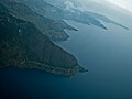
Aerial view of Lake Toba.
Aerial view of the southern shore, with the island of Sibandang visible at the bottom.

View of the lake with an example of Batak architecture in the foreground.

Traditional Batak House in Ambarita, Lake Toba.
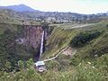
Sipiso-Piso Cascade.


Contenido relacionado
Saint Kitts and Nevis
Calvarrasa de Arriba
Stalactite