
Lake Onega
The Lake Onega (Onego, in Russian, Оне́жское о́зеро; in Finnish, Ääninen or Äänisjärvi; Karelian Oniegu u Oniegu-järve; Vepsian Änine or Änižjärv) is a large lake in northwestern European Russia, whose waters belong to the Republic of Karelia, Leningrad Oblast and Vologda Oblast. The main cities on the lake are Petrozavodsk, the capital of Karelia (266,160 inhab. in 2002), Kondopoga (34,863 inhab. in 2002) and Medvezhyegorsk (15,698 inhab. in 2008).
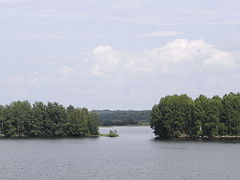
It is the second largest lake in Europe (after nearby Lake Ladoga), with an area of 9894 km², a volume of 280 km³ and a maximum depth of 120 m. It has about 1650 islands, with a total area of just over 250 km². 58 rivers flow into it, the main ones being the Shuya (194 km), the Suna (280km), the Vodla (149km) and the Vytegra (40 miles). The lake empties through the Svir River into Lake Ladoga.
In the northern part of the lake is the Kiji Archipelago, a UNESCO World Heritage Site. It houses a historical complex of 89 Orthodox wooden churches and other wooden constructions from the 15th to the 20th centuries and includes about 1,200 petroglyphs (rock carvings) located on the eastern coast from the 2nd to 4th millennium BC.
The lake is part of the White Sea-Baltic Canal waterway, opened in 1933.
Geological history
The lake is of glacial-tectonic origin and is a remnant of a larger body of water that existed in that area during an Ice Age. In geologic terms, the lake is fairly young, formed—like almost all other northern European lakes—through the carving activity of continental ice sheets in the latter part of the last Ice Age, 12,000 years ago. In the Paleozoic era (300-400 million years ago) the entire territory of the modern lake basin was covered by a marine platform located near the ancient, almost equatorial, Baltic continent. The sediments at that time—sandstone, sand, clay, and limestone—formed a layer about 200 m thick that covered the Baltic Shield, composed of granite, gneiss, and nephrite. When the glaciers withdrew at the end of the Ice Age, the Littorina Sea was formed. Its initial level was about 7-9 meters higher than it is today, but little by little it decreased, thus decreasing the maritime zone and giving rise to the formation of several large lakes in that Baltic region.
Topography and hydrography
Lake Onega has a surface area of 9,700 km², without islands, and a volume of 280 km³; its length is 245 km and its width is about 90 km. By area, it is the second largest lake in Europe and the 18th largest lake in the world. The southern shoreline has a mostly low and continuous shoreline, while the northern shoreline is rocky and steep.

1 - Svirsk Bay
2 - Petrozavodsk Bay and Petrozavodsk City
3 - Big Onego Bay
4 - Kondopozhskaya Bay
5 - Small Onego Bay
6 - Zaonezhsky Bay
7 - Povenetsky Bay
8 - Kizhi Island
9 - Vodlozero Lake and Vodlozero National Park
10 - Ivinsky Spill and Svir River
11 - Cabo Besov Nos ("Devil's nose")
12 - Big Klimenetsky Island
The lake has several deep bays, very elongated in shape, which make its shape resemble that of a giant crab. In the northern part there is a large peninsula, that of Zaonezhye (Заонежье); South of it is the Great Klimenetsky Island (Большой Клименецкий). To the west of them is a deep area (more than 100 m), the Great Onego (Большое Онего), with the bays of Kondopozhskaya (Кондопожская губа) (depth up to 78 m), Ilem-Gorskaya (42 m), Lizhemskoy (82 m) and Unitskoy (44 m). To the southwest of the Greater Onega is Petrozavodsk Onego (Петрозаводское Онего), with the long Petrozavodsk Bay and the small bays of Yalguba and Pinguba. To the east of Zaonezhye there is another large inlet, the northern part of which is called Povenetsky Bay, and the southern part Zaonezhsky Bay. There are deep sections that alternate with banks and islands that divide the bay into several parts. The southernmost part of all, Little Onega, is 40-50m deep. All shores are stony.
The average depth of the lake is 31 m and the deepest place is located in the northern part (127 m). The average depth is 50-60 m in the center and decreases to 20-30 m in the southern part. The bottom has a very uneven profile, covered with sediment, and has numerous trenches of various sizes and shapes in the northern part, separated by large shallow banks. That bottom structure is favorable for fish, and the banks are used for commercial fishing.
The water level is regulated by the dam of the Verhnesvirskaya hydroelectric power station and varies only 0.9-1.5 m per year. It rises due to spring floods, which last 1.5-2 months. The water level is higher in June-August and the minimum occurs in March and April. The rivers dump 15.6 km³ of water per year into the lake, that is, up to 74% of the water balance; the rest is provided by precipitation. Most of the lake's water (84% or 17.6 km³/year) leaves through a single outfall, the Svir River, with the remaining 16% evaporating on the surface.
There are frequent storms, more characteristic of a sea than a lake; waves of 2-3 meters are not uncommon and can even reach 5 m. Near the coast and in the bays the lake freezes in late November-December, and its center in mid-January. The melting begins in April in the tributaries and reaches the lake in May. The water in the deep parts is clear, with a visibility of up to 7-8 m; in the bays, visibility can drop to about a meter. The water is fresh, with a salt content of 35 mg/l. It is relatively low for a lake and is about 1.5 times lower than in another large lake in the area, Lake Ladoga. The maximum surface temperature of the water in the lake is 20-24 °C and up to 24-27 °С in the bays. The deep waters are much colder: 2-2.5 °С in winter and 4-6 °С in summer. The climate in the region is relatively cold, with temperatures below 0 °C for half the year and with average summer temperatures of 16 °C.
Basin and islands

The catchment area of Lake Onega is 51,540 km², with 58 rivers and more than 110 tributaries flowing into it, including the Shuya (194 km), the Suna (280 km), the Vodla (149 km), the Vytegra (64 km) and the Andoma. The only outfall is the Svir River, which marks the southern limit of Karelia. The river runs from the southwestern shore of Lake Onega to Lake Ladoga, which drains by the Neva River into the Gulf of Finland.
The White Sea-Baltic Canal, the navigable connection between the White Sea and the Baltic Sea, runs through the lake. The 368 km Volga-Baltic Waterway connects Lake Onega with the Volga River, the Caspian Sea and the Black Sea. The 67 km Onega Canal, which follows the southern shore of the lake, was built in 1818-20 and 1845-52 between the mouths of the Vytegra River in the east and the Svir River in the west. The canal forms part of the Mariinsk canal system, a forerunner of the Volga-Baltic waterway, and intended to provide a calm passage for ships to avoid the often stormy waters of the lake. It is around 50 meters wide, and lies between 10 meters and 2 km from the shores of the lake. Currently the channel is not used for navigation.
There are about 1,650 islands in the lake, with a total area of about 250 km². Although the most famous is the island of Kizhi, with its historic 18th-century wooden churches XVIII, the largest island is Great Klimenetsky, with an area of 147 km². It has a few settlements, a school, and a central hill whose maximum height is 82 meters. Other large islands are Great Lelikovsky and Suysari.

Sosnowets Island

Petrozavodsk Bay
Some minor islands


The coastal region is covered by dense virgin forests. The three main types are coniferous, but linden, elm, and European alder are also common. The most common animals in the area are the moose, the brown bear, the wolf, the fox, the squirrel, the hare, the lynx, the marten, the European badger, as well as the muskrat and the mink, native to America that they were introduced to the area in the 20th century. About 200 species of birds from 15 different families have been observed in the lake basin.
Lake Onega is home to a wide variety of fish and aquatic invertebrates, including relics from the glacial period, such as lampreys. There are about 47 species of fish from 13 families, such as sturgeon, lake salmon, lake trout, brook trout, European smelt, grayling, roach, Crucian carp, whitefish, gobies, char, pike, European cisco, common carp, silver carp, gold carp, sable carp, spined loach, catfish, European eel, rudd, ide, goby, walleye, perch, ruff, and burbot.
Ecology
Although the lake area used to be virgin, the level of pollution is gradually increasing, especially in the north-western and northern parts which are home to the industrial facilities of Petrozavodsk, Kondopoga and Medvezhyegorsk. About 80% of the population and more than 90% of the basin's industries are concentrated in these areas, with about 190 million m³ of wastewater and 150 tons of emissions per year. The resulting human activity requires some 315 million m³ of drained water per year, of which 46% is industrial and domestic, 25% is stormwater runoff, and 16% is land improvement. This drainage contains 810 tons of phosphorus and 17,000 tons of nitrogen; 280 and 11,800 tons of these elements are disposed of through the Svir River, while the rest accumulates in the lake. Ships and motor boats (around 8,000 units) contribute about 830 tons of hydrocarbon pollution per year, in addition to phenols (0.5 tons), lead (0.1 tons) and oxides of sulfur, nitrogen and carbon.
Economy

The lake basin is a major source of granite, marble and black slate in Russia, which have been mined in the area since the 17th century XVIII. There is also advanced metallurgy, especially in the Petrozavodsk area, which produces about 25% of Karelia's industrial products. The lake's water level is controlled by power plant dams Nizhnesvirskaya hydroelectric plant (Нижнесвирская ГЭС, Lower Svir) and Verzhnesvirskaya (Верхнесвирская ГЭС, Upper-Svir). The first was built between 1927 and 1938 and has a maximum power of 99 MW. Construction of the Verzhnesvirskaya plant began in 1938, but was interrupted by World War II and could only be resumed in 1947. The plant was completed in 1952 and provides 160 MW. The reservoirs associated with the Verzhnesvirsk plant have an area of 9,930 km². and a volume of 260 km³, that is, they are almost equal to Lake Onega itself. Its construction raised the water level of the lake by 0.5 m.
The lake has an elaborate navigation system, as it is part of the Volga-Baltic waterway and the White Sea-Baltic canal, which connects the Baltic, Caspian, and northern seas basins. These canals allow goods to be transported from the lake to different countries, from Germany to Iran, although most of the traffic goes to Finland, Sweden, Germany and Denmark. The Onega Canal, which runs along the southern shore of the lake, is not currently used. Cargo traffic on Lake Onega amounts to 10-12 million tons per year, with about 10,300 ship voyages. On the shores of the lake there are two ports (Petrozavodsk and Medvezhyegorsk), 5 piers (Kondopoga, Povenets, Shala, Vytegra and Ascension (Вознесенье)) and 41 piers.
Fishing is an important activity on the lake. 17 species are commercially fished, mainly European cisco, smelt, whitefish, burbot, pike perch, perch, ruffin, gold carp, lake salmon, pike and, somewhat less, ide, grayling, common carp, common shady and crucian.
Although there is no regular passenger service on the lake, there are several tourist trips a day on the Petrozavodsk–Kizhi, Petrozavodsk–Velikaya Guba and Petrozavodsk–Shala routes. They are carried out by hydrofoil and motor boats and are used for passenger transport. In addition, there are passenger boats that make the Petrozavodsk-Shala route.
Sailing is a very popular activity on the lake and there is a yacht club in Petrozavodsk. Since 1972, every end of July the lake hosts the largest regatta in Russia (Онежская парусная регата), which is part of the Russian Open Championship in the class of Cruisers Yachts "Open800". The regatta has international status.

Boats at the "Kizhi" Pier
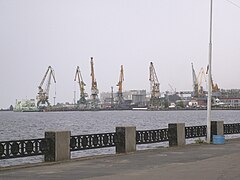
The cargo port of Petrozavodsk

Petrozavodsk in 1915


History and places


Cities
The largest city on the lake is Petrozavodsk, the current capital of the Republic of Karelia (266,160 inhabitants in 2002), founded in 1703 by Peter I to exploit mineral deposits. In the Petrozavodsk area there are large number of historical monuments, such as the architectural ensemble of the Round Square (from the end of the XVIII century) and the Gymnasium from 1790. A series of sculptures, many of them gifts from the Twin Cities, have been erected on the shore of Lake Onega.
Kondopoga has been known since 1495 and the Uspenskaya (Assumption) church built in 1774 stands out. At 42 meters high, it is one of the tallest wooden churches in northern Russia. There are two carillon in the city, with 18 and 23 bells, and also an indoor ice sports arena with a capacity for 1,850 spectators and a Palace of Arts with an organ.
The city of Medvezhyegorsk was founded in 1916 and from 1931 it became the base for the construction of the White Sea-Baltic canal. Between 1703-10 and 1766-69 a factory was operating in the city. During World War II, for three years, this area was occupied by Finnish forces and was the site of many military activities.
Kizhi Island
The main attraction of the lake is the island of Kizhi, in the northern part of the lake, which is a State Historical, Architectural and Ethnographic Conservation Area. There are 89 wooden architectural monuments from the 15th to the 20th centuries on the island. The most notable is Kizhi Pogost, from the 18th century century, consisting of a twenty-two-domed summer church, a nine-domed winter church domes and a bell tower. The Pogost was included in the UNESCO World Heritage list in 1990. In the summer period there are daily boat connections to the island of Petrozavodsk.
Onega Petroglyphs
Another of the attractions of Lake Onega are the petroglyphs (rock carvings). They are located on the eastern shore of the lake and date back to the second to fourth millennia BC. There are around 1,200 petroglyphs scattered over a 20 km area, including several headlands, such as Besov Nos (see map above). The engravings are 1-2mm deep and depict animals, people, boats and geometric shapes such as circular and crescent shapes.
Others
There are many more historical monuments scattered throughout the lake area, such as the Svyat-Uspensky Monastery at Cape Murom on the eastern shore. The monastery was founded in 1350, closed in 1918, and was restored in 1991.
Contenido relacionado
Castries
Vermellar
Nepal