
La Manga del Mar Menor


La Manga del Mar Menor is a Spanish town located on a coastline located in the southeast of the Iberian Peninsula, in the Region of Murcia and, after its urbanization in the second half of the century xx, is a tourist center of great importance.
It belongs to the municipalities of Cartagena in its southern part (from kilometer 0 to kilometer 3.5) and San Javier in its northern part (from kilometer 3.5 to kilometer 21), which have formed a consortium to administer the area. The part located to the north of the Encañizadas channel, which gives continuity to the coastline, is part of the protected area of Las Salinas y Arenales de San Pedro del Pinatar and belongs to the municipality of San Pedro del Pinatar.
Geological origin

The coastline that forms La Manga is a spit of land that was structured since the Quaternary by the natural clogging of sandy sediments from the north, especially those contributed from the mouth of the Segura river, which collided with Cabo de Palos and they were deposited on the volcanic elevations of Calnegre and Monte Blanco, as well as the Tertiary sandstone reefs of the Pedrucho, Estacio and Punta de Algas promontories, until about two thousand years ago when they closed almost completely, forming the lagoon of the Mar Menor.
In addition, La Manga is the cause of the formation of the Mar Menor. Its geological origins go back to the Cenozoic Era, when the Baetic mountains were being formed and the Mar Menor was a bay open to the Mediterranean Sea. As a consequence of the folding and uplifting that took place about 10 million years ago, the enormous basin of the Mar Menor received a large amount of sediment from the Campo de Cartagena that gradually clogged the bay.
During these last 2000 years there were periods in which the water level suffered fluctuations, thus it is considered that in the XVII century its level would be about eight or twelve inches higher than its current level.
Geography

The coastline of La Manga forms a strip of land that is 21 km long and extends from Cabo de Palos to the Salinas and Arenales de San Pedro del Pinatar. With a width between 100 and 1,200 m, it partially separates the Mediterranean Sea from the Mar Menor.
Its maximum elevation is the volcanic outcrop of Monte Blanco with a height of 46 ms. no. m.. Due to its geographical location, in La Manga there is little torrential rainfall, with an average annual temperature of approximately 18 °C. It has more than 3000 hours of sunshine a year.
To the west of this tongue of land is the Mar Menor, which is configured as a lagoon connected by channels, called "golas", through which water is exchanged with the Mediterranean Sea that lies To the East. The central gola or El Estacio is an artificial extension and provides access to the marina, however there are the natural golas of Ventorrillo and El Charco in the area of the encañizadas and the completely artificial one of Marchamalo (or north) through which the exchanges between both seas take place.
The communication by road is carried out by a single road, called Gran Vía, which runs from Cabo de Palos until ending at Punta de los Guzmanes, the northern end of La Manga, which is located in the area of the encañizadas, this The highway begins at the end of the RM-12 expressway and establishes communication with the various urbanizations such as Umenor, Monteblanco, the widening of Calnegre, el Pedrucho, the Oasis, which is where the marina with its piers is located, until reaching Veneziola, which It is the last urbanized area. Below are the boundaries of the Salinas y Arenales de San Pedro del Pinatar natural park.
Natural values

Until the 16th century La Manga was covered with a thick vegetation cover formed by juniper groves of juniper from the dunes (Juniperus turbinata), maritime juniper (Juniperus macrocarpa) and Aleppo pine (Pinus halepensis). This coastal forest was razed by order of King Felipe II to prevent Barbary pirates from taking advantage of its thickness to hide in it.
In 1573 the mayor of Cartagena tried to set a trap for the corsairs by ambushing in the vegetation, but...
"The so-called Moors came covered with the gynaebros [enebros] and çabinas [sabinas]... until they gave birth to the mayor and the others who with him to stag... who could not make any effect with the said horses, that if they swindled [trees and shrubs]... they hurt the sayings... that in the hills and pines... they are so hidden... and they are hidden.
In 1582 the authorities thought of a radical solution: to eliminate all the vegetation of the Manga del Mar Menor, because thus
“would be better discovered the Manga and could walk safely... and discover the entrances and exits of the enemies, which are covered by the saying pine and wood” (Archivo Municipal de Cartagena).
Despite losing much of its original plant cover during the XVI century, La Manga retained a good representation of the coastal dune vegetation until the 1960s, when an unstoppable urban development began that ended most of its natural assets.
The characteristic vegetation of La Manga would be made up of typical dune species such as the marram grass (Ammophila arenaria), the maritime daisy (Asteriscus maritimus), the sea thistle (Eryngium maritimum) and the sea lily (Pancratium maritimum). Especially noteworthy are the few specimens of the Mar Menor asparagus (Asparagus macrorrhizus), an endemic species in the lagoon environment and in critical danger of extinction, with most of its specimens on developable plots in the surroundings of Veneziola, as well as the sea carrot (Echinophora spinosa). In addition, other species would appear, not specific to dune ecosystems, such as the shrimp (Lycium intricatum), the mastic (Pistacia lentiscus) and Ibero-Africanisms such as the oroval (Withania frutescens) and the cornical (Periploca angustifolia).
Regarding the old juniper groves described in the XVI century, of the juniper of the dunes (Juniperus turbinata), in danger of extinction, only a few specimens remain in the Salinas y Arenales de San Pedro del Pinatar natural park, while the maritime juniper (Juniperus macrocarpa) is completely extinct on the coasts of the Region of Murcia.
Sculpture of the Mar Menor in Veneziola, a species in critical danger of extinction.
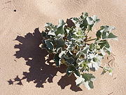
sea carrot (Echinophora spinosa) in a plot of La Manga.

Senecio glaucus in a sandal north of La Manga.
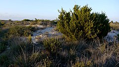
Sabina de las dunes (Juniperus turbinata) in the sandals of San Pedro del Pinatar, representative of what could be the old vegetable deck of La Manga.
marine cardo (Eryngium maritimum).

Sandals with varnish (Ammophila arenaria).


Regarding the fauna that inhabited La Manga in historical times, the hunting book of Alfonso XI of Castile mentions in the century XIV the presence of wild boars (Sus scrofa) in Cabo de Palos and deer (Cervus elaphus) in La Manga.
"The mountain of Cabo de Palos is very good mountain of Puerco in winter, and this mountain is near the sea. And near the mountain is an island, which enters the sea: and a league lasts well, and there are many bandages in it." Book of Montería de Alfonso XI century XIV
Until the middle of the 20th century, loggerhead turtles (Caretta caretta) came to lay their eggs in its sands and the monk seal (Monachus monachus) inhabited its beaches.
Protected areas
This area of sedimentation lands was made up of dunes and scrub vegetation that arrived with few changes until the 1960s, a decade in which the area was promoted for tourism and large constructions gradually began to populate the landscape considering its strategic position between two seas.
Currently, most of La Manga is urban land and only small patches of what was its original vegetation remain, and the deer and wild boar have completely disappeared.
Some areas have been protected and in it it is possible to get a certain idea of what the original landscapes of La Manga del Mar Menor were like:
- The natural park of the Salinas and Arenales of San Pedro del Pinatar is located on the northern edge of La Manga and is the best representative space of the various ecosystems that formed this coastline in ancient times. It is protected with the category of natural park, as well as Place of Community Importance and Special Protection Zone for Birds within the Natura 2000 Network of the European Union.
- The Salinas de Marchamalo are located at the southern end of La Manga and are included within the so-called Open Spaces and islands of the Lesser Sea, protected with category of natural park, as well as LIC. Salinas are the habitat of an endemic fish of the southeast in danger of extinction, the fartet (Aphanius iberus), and hosts populations of different aquatic birds, such as flamenco (Phoenicopterus roseus) or adouin seagull (Larus Audouinii). Among the vegetation protected in this protected space are the halophytic species that grow on saline soils, such as sea lettuce (Limonium cossonianum), the Sosa alacranera (Sarcocornia fruticosa), the sosa (Suaeda vera) or the sprace of the Mar Menor (Asparagus macrorrhizus), in critical danger of extinction.
- On the beach of the Amoladeras, also included within the Open Spaces and islands of the Minor Sea a minimum rest of the ancient vegetation typical of the dunes, with species characteristic of these ecosystems such as the sea quarry (Lotus creticus), alwaysviva yellow (Helichrysum stoechas), the varnish (Ammophila arenaria), the sea omum caritimum. In 2012, environmental restoration tasks were carried out in this space of the Amoladeras, which included the withdrawal of invasive species, mainly acacias, and the planting of numerous specimens of the dunes (Juniperus turbinata), disappeared from this area since remote times, and lentisco (Pistacia lentiscus).

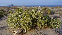
Arenales de San Pedro del Pinatar, an image of the appearance that La Manga might have before its urban development.

Flamencos (Phoenicopterus roseus) in the Salinas de Marchamalo.

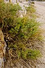
Cambron (Lycium intricatum) in the encañizadas to the north of La Manga, on the southern edge of the Natural Park of the Salinas and Sandles of San Pedro del Pinatar.

Dunar vegetation on the beach of the Amoladeras.


Environmental problems
In La Manga, an excessive urbanization process was carried out that has given rise to environmental problems, such as the disappearance of dunes and natural beaches, the drying up of lagoons, continuous dredging, the elimination of landscape values and the loss of biodiversity or even the alteration of the original environmental conditions of the Mar Menor, such as salinity.
The beaches of the Mar Menor suffer the consequences of the degradation of the lagoon, caused by the change from a rainfed agricultural model to irrigated agriculture in the surrounding area, which releases nitrates and produces eutrophication, developing the so-called &# 34;green soup", causing anoxia or lack of oxygen that sometimes causes the death of fish in the salty lagoon.
Beaches


The beaches that this geographical feature has are:
In the municipality of Cartagena
|
|
In the municipality of San Javier
|
|
Islands
On both sides of the coastline there are several islands of volcanic origin:
In the Minor Sea
| In the Mediterranean Sea or the Greater Sea
|
History
Prehistory
Neolithic site of Las Amoladeras
The oldest documented presence of man in La Manga dates back to the Eneolithic period, since vestiges of a town from that time have been found on Las Amoladeras beach. In this space, a prehistoric settlement has been documented and excavated, from the end of the Neolithic and the Copper Age, dated between 2500 and 1800 BC. Said settlement, in the opinion of Professor García del Toro, would be made up of a series of circular cabins, surrounded by a fortified wall, similar to the one existing in Cabezo del Plomo in Mazarrón. It would be inhabited by a society of hunters and gatherers, especially focused on fishing and shellfishing. Some objects from the excavations carried out in this space can be seen in the Municipal Archaeological Museum of Cartagena. Since 1987 it has been declared an asset of cultural interest (BIC)
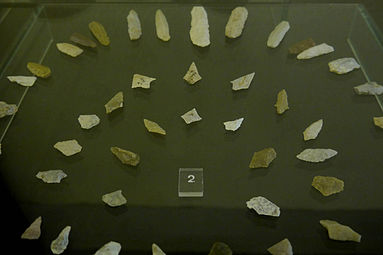
Neolytic arrow tips from Las Amoladeras.

Neolytic Necklaces from Las Amoladeras.


Bronze Age village in Cala del Pino
In 1987, an urgent archaeological excavation verified the presence of a prehistoric settlement on the hill of Calnegre, the promontory that dominates Cala del Pino. The ceramic remains and other materials collected allowed us to date the site between the 13th and 11th centuries BC. C. (late-final bronze), which consisted of a town with stone walls and a bastion. In 2011, the General Directorate of Fine Arts and Cultural Assets adopted a resolution endowing it with legal protection, published in the Official Gazette of the Region of Murcia.
Antiquity
In ancient times, the coastline of La Manga did not completely close the passage to the Mar Menor, which allowed the lagoon to be navigable during the period of the Phoenician, Greek and Roman colonizations. An example of these maritime routes to Through La Manga it is made up of the Iberian settlement of Los Nietos, next to the Mar Menor, discovered in the 1960s and which in the 4th century B.C. C. exercised the role of commercial base of the area in which products derived from mining were exchanged for goods from Greece, Campania and the eastern Mediterranean.
It is also known that Phoenician and Roman ships used El Estacio as a docking area, with archaeological remains in Punta de Pudrimel, El Estacio and Bajo de la Campana, as well as remains of Roman wrecks in San Ferreol.
Middle and Modern Ages
During the Middle Ages, the first canals were installed for fishing. In the XIV century, the hunting book of Alfonso XI of Castile mentions La Manga as a place where wild boars and deer abound.

The 16th and 17th centuries are marked by the defense of the territory against the incursions of Berber piracy. During the reigns of Carlos V and Felipe II, a series of coastal watchtowers were built to prevent these Berber attacks along La Manga. These towers were:
- Cabo de Palos Tower, San Antonio call. Hexagonal plant and built in 1578. Disappeared. Part of their chairs were used in the construction of the current Cape of Palos lighthouse in 1862.
- Torre del Estacio or San Miguel. Completed in 1601 and of circular plant, it was placed on a communication goal between the Mediterranean Sea and the Minor Sea. Demolished in 1861 for the construction of the Stacio Lighthouse.
- Torre de la Encañizada. Situada como la anterior en una gola de comunicación entre el Mediterranean y el Mar Menor, protegería una de las encañizadas. Circular plant. Disappeared.
- Torre del Pinatar, located on the beach of Torre Derribada in the municipality of San Pedro del Pinatar. Built in 1602. disappeared.
At the end of the XVI century, to prevent the Barbary pirates from using the vegetation to ambush themselves, all the Sabina juniper grove of the dunes and maritime juniper was devastated and La Manga was completely devoid of its original vegetation.
Contemporary Ages

The confiscation process put the land up for public auction on January 10, 1863 and it was acquired by various owners. Miguel Zapata gradually bought the various areas, inherited by the Maestre family. In 1956 Tomás Maestre Aznar managed to dispose of almost all the land and began the process for its urbanization.
This zone of sedimentation lands was made up of dunes and scrub vegetation that arrived without any change until the 1960s, a decade in which the area was promoted for tourism and large constructions gradually began to populate the landscape considering its strategic position between two seas. In 1970 it had fifteen homes but in 1981 they had risen to 4,730 which reflects accelerated urbanization.
At the end of the XX century, it could be considered the only specialized tourist space in the Region of Murcia that could offer more of 3000 hotel beds.
Transportation
Bus
_-_Alsa_3989.jpg)
The town's road passenger service is included within the Movibus brand, an interurban public transport system in the Region of Murcia (Spain), which includes regionally owned bus services. The lines of the concession MUR-004 "Metropolitana Cartagena-Mar Menor" are operated by ALSA (TUCARSA).
| Line | Tour |
|---|---|
| 15 | Cabo de Palos - Pedruchillo - Puerto Tomás Maestre - Veneziola (Bus Manga) |
| 20 | Cartagena - Cabo de Palos - La Manga (Pedruchillo) |
| 22 | La Manga (Pedruchillo) - Los Urrutias (Búho Mar Menor / Solo Summer) |
It also has connections with Murcia.
Economy

The main economic activity is tourism and the services associated with it, it is also a temporary activity since during the summer months the population can exceed 200,000 inhabitants and yet during the rest of the year it does not usually arrive at 14,000. It is the tourist destination in the Region of Murcia in which, despite the existence of a large number of second-home homes, the number of foreign tourists exceeds that of those from the Region. La Manga offered in 2019 more than a third of the hotel beds in the Community. In the area of the municipality of Cartagena there were 2,734 hotel beds available, more than 60%, while in San Javier 1,752 beds were offered, almost the remaining 40%.
The predominant activities are related to leisure activities, with a considerable offer of water sports and activities, highlighting those of sailing due to the excellent conditions for its practice that the Mar Menor meets. Other highly requested activities are scuba diving or diving and therapeutic spas. The great biodiversity that due to the characteristics of this area is concentrated under the sea is an attractive factor for tourists. It also offers the largest outdoor mud therapy area in Europe. Its sludge is taken freely in Las Charcas de las Salinas de San Pedro, in Lo Pagán. Regarding thalassotherapy, the waters of the Mar Menor contain a lot of salt and are rich in minerals, and are very effective in combating all kinds of pathologies related to the joints.
In addition to having a warm climate you can visit its numerous and long beaches in various holiday periods.
The offer of hotels of all categories and innumerable restaurants make the hotel industry its main service area. But also the commercial galleries and markets, shops, hardware stores, nautical stores and all kinds of commerce related to the practice of water sports, in addition to the beach bars and discos on the beach, everything is offered as an added attraction.
Gastronomy is also an important aspect of the economy as it attracts tourists. The typical dishes that we can find in La Manga are the typical cauldron of the Mar Menor, the "mojete murciano", the michirones and the meats "al ajo cabañil". In fish, gilthead and mullet stand out. The quality of the fruit, vegetables and vegetables from the Murcia orchard and Campo de Cartagena also lend a healthy touch of color to the dishes.

Filmography
The promotion of the area led to several films being shot: in 1969 the film La vida sigue igual starring Julio Iglesias and in 1970, In a place in La Manga , starring Manolo Escobar and Concha Velasco. In the 1980s, the erotic film South of Eden, directed by Ismael González, was shot.
Demographics
La Manga del Mar Menor has experienced a high increase in its population, mainly due to tourism, reaching 200,000 inhabitants in the summer season, although the registered population is barely 17,000 inhabitants. In 2014, for the first time, the population decreased and was below 17,000 registered, specifically with 16,818 inhabitants.
| Graphic of demographic evolution of La Manga del Mar Menor between 1900 and 2022 |
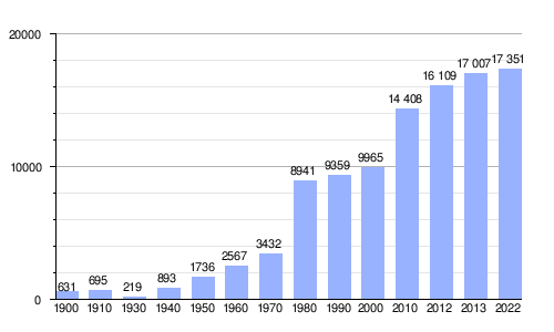 |
Source Spanish National Statistical Institute - Graphical Development by Wikipedia. |
Local administration
As it belongs to the municipalities of Cartagena and San Javier, the supply of services and their management requires a certain amount of collaboration between the two, although they do not always coincide in their development. The dysfunctions that occur have given rise to citizen movements that have requested their segregation.
On segregation
.jpg)
La Manga, as explained in the previous paragraph, is divided between two municipalities: Cartagena and San Javier. Cartagena corresponds to it from kilometer 0 (the southern limit of what would be the strip of sand that is next to Cabo de Palos), to km 3/4 in an area known as Monteblanco; From this point on, it is the San Javier City Council that is responsible for the maintenance of La Manga. Due to these curious administrative circumstances, in which the population centers are no less than 30 km away in the case of Cartagena and some 50 km by road in the case of San Javier (although by sea it is less than three km), they make of La Manga a difficult entity to manage.
For this reason, the councils of these two municipalities collaborate jointly in the maintenance of beaches, roads, etc. known as El Consorcio, but although the population of La Manga (when we refer to La Manga it is only the sandy arm, not the towns on the Mar Menor coast) fluctuates throughout the year, since it increases in holiday periods of the periods that are not, more and more people, little by little, are making it the place of habitual residence, both for people from the area and for foreigners. And it is these that have shown that there are no services the rest of the year (as effective as they are in summer), this has led to not only La Manga, as an urban entity, but also certain populations dependent on Cartagena such as Cabo de Palos, Los Belones and others from the Rincón de San Ginés council have requested its segregation, and the formation of another agglutinating municipality based in La Manga, with the name of Dos Mares. The characteristics of the law on the formation of municipalities, such as remoteness from the urban center of the dependent municipality or also with respect to deficient services (only in autumn-winter) have not served for petitions to the State to allow them to form as a municipality, being rejected by the Superior Court of Justice of Murcia and definitively, upon appeal, by the Supreme Court.
La Manga Overview

Contenido relacionado
Zhytomyr Oblast
Flavian testimony
Sebastian of Milan