Kattegat
The Kattegat Strait —or Categat, in old Spanish— is a strait between Jutland and the Swedish west coast, connecting the Baltic Sea with the North Sea (via the Skagerrak). It extends for about 220 km following a north-south axis.
Because the islands of Zealand and Funen almost block the southern strait, it is also sometimes referred to as a bay rather than a strait. The union with the Baltic is made, either by the Øresund to the southeast (between Zealand and the Scandinavian peninsula), or by the Great Belt (Storebælt) in the center (between Funen and Zealand), or by the Little Belt (Lillebælt) to the southwest (between Jutland and Funen).
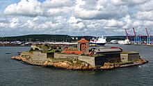
It has several islands, the largest of which are Samsø, Læsø and Anholt, all known for their dry climate (by Danish standards). There is also Bondaholmen.
Its name comes from the Dutch or Low German words kat ("cat") and gat ("hole"), referring to the difficulties of navigation that It was presented to medieval captains due to its narrowness, due to the many sandbanks that it presented.
Geography
As defined in a 1932 convention signed by Denmark, Norway, and Sweden (recorded in the League of Nations Treaty Series of 1933-1934), the northern boundary between the Kattegat and the Skagerrak lies on the Skagen's northernmost point in Jutland, while the southern boundary to the Øresund is at the tip of the Kullen peninsula in Skåne.
The main watercourses that flow into the Kattegat are the Göta älv rivers in Gothenburg, along with the Lagan, Nissan, Ätran and Viskan in the province of Halland on the Swedish side, and the Gudenå river in Jutland, in Denmark.
The main islands of the Kattegat are Samsø, Læsø and Anholt; These last two, due to their relatively dry climate, are located in what is called "the Danish desert belt".
The Kattegat is surrounded by several important coastal areas, such as the Kullaberg Nature Reserve in Skåne, Sweden, which contains several rare species and a picturesque rocky coastline, the town of Mölle, with a picturesque harbor and views of the Kullaberg, and Skagen, in the far north of Denmark.
Since the 1950s, a bridge project often referred to as the Kattegatbroen (the Kattegat Bridge) has been under consideration, connecting Jutland and Zealand across the Kattegat. Since the late 2000s, the project has seen renewed interest from a number of influential politicians in Denmark. It is commonly thought that the bridge will connect Hov (a town south of Odder, in the Aarhus area) with Samsø and Kalundborg.
Marine limits
The International Hydrographic Organization, the highest international authority on the delimitation of seas, considers the Kattegat as part of one of its seas, which it calls "Kattegat, Sound and Belts". In his world reference publication, Limits of oceans and seas (“Limits of oceans and seas”, 3rd edition of 1953), he assigns it the identification number 2 and defines it as follows:
In the North,
A line that unites Skagen (Skaw, northern tip of Denmark) and Paternoster Skaer (57o54'N, 11o27'E) and from there in the northeast direction through the bass of Tjörn Island.
In the South,
The boundaries of the Baltic Sea, the Belts and the Sound.On the North,
A line Joining Skagen (The Skaw, North Point of Denmark) and Paternoster Skaer (57o54'N, 11o27'E) and thence Northeastward trought the shoals to Tjörn Island.
On the South
The limits of the Baltic Sea in the belts and Sound.Limits of oceans and you are, p. 5.
Biology
In the Kattegat, salinity has a pronounced two-layer structure. The upper layer has a salinity between 18‰ and 26‰ and the lower layer -separated by a strong halocline at about 15m- has a salinity between 32‰ and 34‰. The lower layer is made up of seawater from the Skagerrak, with a salinity equivalent to that of most coastal waters, while the upper layer is made up of seawater from the Baltic Sea and has a much lower salinity, comparable to that of brackish water, but still much higher than that of the rest of the Baltic Sea. These two opposing flows transport a net surplus of 475 km³ (114 cu mi) of seawater from the Baltic to the Skagerrak each year. During the strongest winds, the layers of the Kattegat mix completely in some places, such as the Great Belt, so the general salinity is highly variable in this small sea. This creates unique conditions for marine life.
Cold seeps, known locally as bubbling reefs (Danish: boblerev), are found in the northern Kattegat. Unlike the cold seeps of most other places (including the North Sea and the Skagerrak), the bubbling reefs of the Kattegat lie at relatively shallow depths, generally between 0 and 30 m below the surface. Seeps are based on methane deposited during the Eemian period and, in calm times, bubbles can sometimes be seen on the surface of the water. Cementation and lithification of carbonates form slaps or pillars up to 4 m high and support rich biodiversity. Due to their unique condition, the Kattegat's bubbling reefs receive a level of protection and are recognized as a Natura 2000 habitat (type 1180) by the European Union.
Ecological collapse
The Kattegat was one of the first marine dead zones to be observed in the 1970s, when scientists began to study how intensive industrial activities affected the natural world. Since then, studies and research have contributed much data on processes such as eutrophication, and on how to deal with it. Denmark and the EU have launched costly and far-reaching national projects to stop, repair and prevent these environmentally destructive and economically damaging processes since the first Aquatic Environment Action Plan in 1985, and are now busy implementing the fourth Action Plan. The action plans summarize a wide range of initiatives and include the so-called Nitrates Directives. The action plans have been generally considered a success, although the work is not complete and not all targets have yet been achieved.
Contenido relacionado
Kingdom of Iberia
Watershed
Maracay
Machu Picchu base
Wadati-Benioff zone
