
Juarez City
Ciudad Juárez (![]() pronunciation (?·i)), officially Heroica Ciudad Juárez (from 1659 to 1888, The Northern Step), it is a Mexican city located in the state of Chihuahua, being the most populated city of the same and the head of the municipality of Juárez. It is located on the banks of the river Bravo in the northwest region of Mexico. It is a border and industrial city that, together with El Paso, Texas, forms the second largest transnational metropolitan area in Mexico and the United States, which is around 2.5 million inhabitants, the same as the largest ninth in Mexico. The city, with a population of 1 501 551 inhabitants According to the INEGI Population and Housing Census 2020, it is also the sixth most populous in the country.
pronunciation (?·i)), officially Heroica Ciudad Juárez (from 1659 to 1888, The Northern Step), it is a Mexican city located in the state of Chihuahua, being the most populated city of the same and the head of the municipality of Juárez. It is located on the banks of the river Bravo in the northwest region of Mexico. It is a border and industrial city that, together with El Paso, Texas, forms the second largest transnational metropolitan area in Mexico and the United States, which is around 2.5 million inhabitants, the same as the largest ninth in Mexico. The city, with a population of 1 501 551 inhabitants According to the INEGI Population and Housing Census 2020, it is also the sixth most populous in the country.
It has an economy based mainly on the maquiladora industry made up of more than 380 of these companies, which are strategically located at border bridges and quick access areas, have US investors, and its economy is also based on the merchandise export. Most of the inputs come from the United States and the companies are US subsidiaries that settle in Mexico to take advantage of the low cost of the labor factor. In order not to incur freight costs and for logistical reasons, a large part of these industries are installed in cities along the border: Matamoros, Reynosa and Nuevo Laredo to the east, Ciudad Juárez in the center; and Nogales, Mexicali and Tijuana to the west.
Originally it was founded under the name of El Paso del Norte, receiving its current name in 1888 in honor of Benito Juárez, who took refuge in the city during the second French intervention. Ciudad Juárez is next to the city of Chihuahua, one of the cities in the north of the country with the greatest historical relevance for the nation; For example, the city has been on more than one occasion the provisional capital of the Republic under the mandates of Presidents Benito Juárez, Francisco I. Madero and Venustiano Carranza, and also the headquarters of General Francisco Villa. Due to the large number of maquiladora companies that it owns, the city is, along with the cities of Monterrey and Tijuana, one of the three most important industrial points in northern Mexico.
The designation of “Heroica Ciudad Juárez” was made at the request of the governor of the state of Chihuahua César Duarte Jáquez, which was approved in 2011 by the Congress of the State of Chihuahua, due to the important role that the city played in the Mexican Revolution, mainly during the Maderista Revolution; and likewise, taking advantage of the centenary of the taking of Ciudad Juárez, to highlight the great historical importance of the city at a national and international level, in response to the increase in insecurity in the city and after being declared for 4 consecutive years (2008 - 2012) as the most insecure and violent city in the world, having bottomed out in 2010. Even today, insecurity is one of the main problems that the city faces. The heroic character is used officially in the logo of the Municipal Government of the period 2013-2016, by Enrique Serrano Escobar.
History
Viceroyalty
The region where Ciudad Juárez is located today was inhabited since the late 1500s, almost 100 years before the year it was founded. The region served as an outpost and barracks for the Spanish conquistadores. In 1595, with the permission of King Philip II of Spain, Spanish explorations began to colonize the territory of New Mexico, and in 1598 the explorer Juan de Oñate claimed possession of the territories beyond the River for the Viceroyalty of New Spain. Bravo (the Rio Grande for Americans) calling the crossing point Paso del Norte (currently where the border cities of El Paso and Ciudad Juárez are located).
In 1659, Franciscan friar Fray García de San Francisco founded what is now both Ciudad Juárez and El Paso, Texas, under the name Mission of Our Lady of Guadalupe de Mansos del Paso del Río del Norte, and built the mission of Guadalupe, which today is located next to the Cathedral of Ciudad Juárez.
Throughout the viceregal era, Paso del Norte was the main center of Spanish colonization towards the territory of New Mexico, as it constituted an obligatory step along the so-called Camino Real de Tierra Adentro, currently declared a World Heritage Site, which linked the center from Mexico with the city of Santa Fe, it was also one of the few points where you could cross the then very mighty Rio Grande (which received this name due to its strong avenues), also in its surroundings there were no warlike tribes that resisted in Very much the Spanish government, its original settlers were the tame Indians who were named like that by the Spanish due to their docility and other groups such as the sumas did not offer much resistance either, making it a very safe point. Because of this, during the rebellion of the Pueblo Indians in New Mexico, a large part of the Spanish and mestizo population of that region and their government took refuge in the Paso del Norte and from there the military reconquest and recovery of the territory was reorganized.
At the same time as its political situation, Paso del Norte was also an important religious center from which numerous missions were established in New Mexico led by Franciscan priests in charge of the evangelization of this area, becoming the second most important evangelizing center only after Santa Fe. This led to conflicts between the different ecclesiastical authorities since the Franciscans did not easily accept the authority of the secular clergy in their affairs, all the territory that is today the states of Chihuahua and New Mexico were part of the then Diocese of Durango, with whose bishop the Franciscans had a bad relationship and opposed his visits, although they were finally forced to receive a visit from Bishop Benito Crespo y Monroy in 1725.
Independence
As in the rest of what we know today are the states of Chihuahua and New Mexico, the independence movement that had broken out in the Bajío had little or no repercussions in the area, even in 1811 when Miguel Hidalgo and the main caudillos of the movement were shot in what is now the state capital; After the triumph of the independence movement in 1821 led by Vicente Guerrero and Agustín de Iturbide, the entire province joined him and when the federal republic was consolidated in 1824 and the new state of Chihuahua was established on July 6 of the same year, Paso del Norte was included in it.
The first constitution of the state of Chihuahua was promulgated on December 9, 1826, and on January 5, 1826, Paso del Norte was established as the head of one of the 11 parties into which the state was divided. Decades of independent life, the town of El Paso was mainly dedicated to trade with New Mexico and was famous for the cultivation of vines in its surroundings, whose abundance was one of the main reasons for the development of the area. In 1836 With the change of the federal regime for the centralist one, Paso del Norte ceased to be the head of the party to be that of the District, one of the three into which the now called Department of Chihuahua was divided.

In 1846, the War between the United States and Mexico broke out, which had been brewing since 1836 with the separation of the Republic of Texas from Mexico and the territorial conflicts that this generated, since the Texans claimed the Rio Grande as their border line. Paso del Norte was one of the first objectives of the US Army. An army column commanded by General Alexander William Doniphan occupied the city of Santa Fe and took control of New Mexico and from there advanced towards the town of El Paso, the Mexican troops fought a few kilometers to the north, in the battle of Temascalitos, under the command of Antonio Ponce de León and made up of about 600 men from the National Guard and from the prison companies that fought the Apaches, were defeated. Consequently, the Paso del Norte was occupied by American forces in December 1846.
On February 2, 1848, the Treaty of Guadalupe Hidalgo was signed by which Mexico ceded to the United States more than two million square kilometers of large masses of land in what were then territories of Alta California, New Mexico, and Texas. The Rio Grande remained the boundary of the two nations and the Paso del Norte became a border town, the north bank of the river became United States territory and constituted the town of Franklin, Texas, which would later become the current city of Step. Despite this, the US army remained in Mexican territory for several months and it was not until August 2, 1848 when they finally crossed the Rio Grande in the direction of Franklin, vacating Paso del Norte.
In 1853 a new border adjustment occurred when the territory of La Mesilla was sold to the United States, with which the new border line after the Rio Grande began precisely at Paso del Norte, reinforcing its condition as a border town.
The growth of northern Mexico was greatly aided by advances in communications and transportation. The construction of the railroad in 1884 improved the communication of Paso del Norte with the rest of the country; however, this communication was only from north to south, while El Paso was connected to important points in the east and west of the country, which allowed it to become a kind of "economic satellite" or "international metropolis". On both sides of the border, this had several consequences. For example, emigration is a problem in Paso del Norte due to the lack of job prospects and the high cost of living, while trade is in disarray due to intense competition on the other side of the river. Thanks to the new adjustment border crossing, Paso del Norte began to become the new and largest "free zone" from Mexico.
There has been a free zone in Tamaulipas since 1858, which has helped border residents obtain cheaper items from the Mexican side, but this strategy has hurt merchants in the center of the country. However, with the border adjustment, the installation of the railway and the importance it gave to the border strip with the United States, as well as a request to the federal government to help the local economy, the free zone franchise was granted in 1885. to Paso del Norte, which acted as a catalyst for growth. When Villa Paso del Norte was urbanized, it took on the appearance of a city. The so-called Calle del Comercio, today Avenida 16 de Septiembre, is an example.
The political difficulties in Mexico then continued with the confrontation between liberals and conservatives that would lead to the Second French Intervention in Mexico and the establishment of the Second Mexican Empire. As a consequence of the French invasion, President Benito Juárez was forced to move the government to the north of the country, and on August 6, 1865, it arrived at Paso del Norte, the last point in the national territory where it would settle, the latter after the French occupation of the city of Chihuahua, where it had resided since October 12, 1864, Juárez returned to Chihuahua on November 20, 1865 when it was vacated by the French forces, but in December of the same year he returned to Paso del Norte because the French reoccupied the city of Chihuahua; He remained again in Paso del Norte until June 17, 1866, when he definitively returned to Chihuahua and later to the center of the country. It was at this time when one of the main floods of water occurred through the Rio Grande and caused an important change in its course, leaving on its left bank, that is, the United States, an important area owned by Mexico and which would be known as the Chamizal, the Mexican claims over this territory would extend for almost a century, until it was definitively returned in 1963. The changes in the course of the Rio Grande were continuous during these years, continually changing the margin of small nearby towns such as Ysleta or San Elizario.
.jpg)
The Chihuahua state government saw fit to grant it the title of city in recognition of its achievements. As a result, on July 30, 1888, a decree was issued changing the name of Villa Paso del Norte to Ciudad Juárez, which became effective on September 16, 1888. Ciudad Juárez began to benefit from public services such as public lighting, electrification, drainage, and the development and paving of main roads. However, domestic and foreign opposition to the "unfair" The free zone did not take long to wait and the Mexican government was forced to modify the statute of the free zone in 1891. To this must be added the worldwide devaluation of silver and the scarcity of water, which generated a severe economic crisis in the city, causing a significant number of workers to flee to the United States. As a result of the collapse of commercial activities and population, Ciudad Juárez focused on tourism as an economic activity at the beginning of the XX century, particularly promoting "deviations", with which "the moment of scandal" began.
Revolution
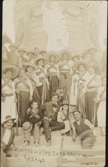
At the beginning of the 20th century, the region became the scene of intense mobilization by revolutionary groups exiled in El Paso. In 1906 the Mexican Liberal Party had planned to start a social revolution to overthrow the dictatorship of Porfirio Díaz on September 16, the signal for at least 44 groups distributed throughout the country to rise up in arms, was the attack on Ciudad Juárez; however, the conspiracy was discovered and postponed. On October 19, members of the PLM from El Paso entered Juárez, but were immediately arrested.
In 1909, an interview was held between Presidents William Howard Taft of the United States and Porfirio Díaz of Mexico.
Forces led by Francisco I. Madero took Ciudad Juárez on May 10, 1911, and this event marked the end of the dictatorship of Porfirio Díaz, which was formalized with the signing of the Treaties of Ciudad Juárez on May 21.
The Chamizal dispute was a border dispute over approximately 1.5 square miles of the United States-Mexico border, between El Paso, Texas, and Ciudad Juárez, Chihuahua. It was due to the differences in the course of the Rio Grande, as analyzed in 1852, and the current channel of the river, it was returned to Mexico until the 1960s, and it was one of the few territories returned by the United States to another country, it was turned into a federal public park.
News
In recent years, the city has been rocked by a spiral of violence caused, in large part, by drug trafficking, which is very active on the border with the United States. In the 1990s and 2000s, public opinion was shaken by a wave of murders of women, mostly poor young men from different parts of Mexico who traveled to Ciudad Juárez in search of work and opportunities. According to INEGI statistics (2004), in Chihuahua 2,387 femicides were committed for every 100,000 women. Most of these murders are not clarified. On the other hand, a fierce fight between rival gangs and the police has broken out in organized crime, with the result that Ciudad Juárez has become one of the most violent cities in Mexico..
These and other antecedents have led to it being previously considered the fifth most violent city in the world.
On February 17, 2010, the INEGI (National Institute of Statistics and Geography) reported that, according to its analysis, since the start of the wave of violence in 2008, close to a thousand inhabitants have left the city.
Politics

Ciudad Juárez is the head of the Municipality of Juárez, one of the 67 municipalities that make up the state of Chihuahua, the government of the municipality corresponds to the city council, which is made up of the municipal president, a figure equivalent to that of mayor, and the council made up of the aldermen. The council is elected for a period of three years that are not re-eligible for the immediate period but not continuously. The seat of the City Council is located in the "Unidad Administrativa Lic. Benito Juárez", located in the center of the city next to the Paso del Norte International Bridge.
Ciudad Juárez is the head of a total of eight local electoral districts of the 22 into which the state of Chihuahua is divided for the election of deputies to the Chihuahua Congress, for the legislature elected for the period from 2007 to 2010, seven of these districts were won by the Institutional Revolutionary Party and one by the National Action Party. For federal representation, Ciudad Juárez is the head of four federal electoral districts, of these, I includes a sector of the urban zone but also a wide territory of the north of the state, while districts II, III and IV are formed only by urban areas; in the elections for deputies for the period 2009 to 2012, districts I, II and IV were won by the Institutional Revolutionary Party and the III by the Action Party National.
For purposes of state administration, the state governor appoints a representative of the state government in Ciudad Juárez, who heads the functions of the state government in said city with the intention of giving greater coordination to its actions due to the great population concentration of the city.
Geography
Location and geographic environment
Ciudad Juárez is located at the geographic coordinates 31°44′22″N 106°29′13″W / 31.73944, -106.48694 and at an altitude of 1,137 meters above sea level, it is located at the point where the border between the United States and Mexico ceases to be marked by the Rio Grande and becomes a geodesic line in an east-west direction and in a wide valley formed by this same river between two mountain ranges, to the north, currently in the United States, the Franklin Mountains that reach 2192 meters above sea level and to the south the Sierra de Juárez that forms in Much of the western limit of the urban area, in the Sierra de Juárez, is located the Cerro Bola, an elevation of formation characteristic of the area, which reaches approximately 1800 meters above sea level.
Ciudad Juárez is located in the middle of the Chihuahuan desert, considered the largest desert in North America. Approximately 50 kilometers south of the city are the dunes of Samalayuca, a protected natural area, characterized by its large fine sand dunes. This environment characterizes Ciudad Juárez for its extreme climate and above all for the strong winds it registers, which together with the proximity of the desert, frequently generate dust clouds in the city.
The city is located 362 kilometers north of the city of Chihuahua and about 1,793 kilometers north of Mexico City taking Federal Highway 45.

Climate

Ciudad Juárez has a desert climate, and temperatures vary greatly from season to season. For this reason, Juárez is considered the Mexican metropolis with the most extreme climate in the nation, due to the fact that in spring there are strong winds with gusts that touch 100 km/h, which generate everything from dust storms to sand storms with zero visibility; in summer there are very high temperatures that exceed 40 °C accompanied by periods with very low relative humidity, and in turn, periods of the summer monsoon where torrential rains of very short duration are recorded that generate severe flooding; and likewise, very harsh winters that are generally accompanied by snowfall as well as most days with temperatures below zero, and periods in which on some days both maximum and minimum temperatures have negative values. The average annual temperature of the city is 16.7 °C, with a thermal oscillation of 22.0 °C between the coldest and warmest months: the average for January is 5.3 °C and for July is 27.3 °C.
The record maximum temperature since records have been 46 °C, in June 1994, while the record minimum has been -23 °C, recorded on January 12, 1962.
Spring and autumn are the seasons in which the climate is mild, since they are the transition between the cold months and the hot ones and vice versa. During these, temperatures remain warm during the day, warm at night and cool at dawn; fluctuate between 27 °C and 10 °C. In these stations, sandstorms generally occur due to the strong winds that are registered, which usually reach gusts of 100 km/h. The only variation between these two seasons is that spring is the dry season of the year and therefore rainfall is nil or little, while in autumn rainfall occurs more frequently and generally with little intensity.
During the summer, temperatures tend to be extremely hot, with temperatures fluctuating between 25 °C and 35 °C, with periods in which the maximum temperatures exceed 40 °C and the minimum temperatures are around 27 °C. This season of the year is the one that receives the most rain due to the periods of the summer monsoon. The rains occur mostly between July and September with an average of 40-50 mm per month, with extraordinary records of up to 150 mm in an abundant year in this sense.
During the winter, temperatures are cool during the day and very cold at night, with temperatures that oscillate throughout the season between 13 °C and -4 °C, rarely exceeding 15 °C and drop from -6 °C, respectively; with the presence of strong cold fronts coming from the north of the continent, which sometimes make the minimum temperatures drop below -7 °C and that the maximum temperatures during the day do not exceed -1 °C, approximately. they are somewhat frequent and occur mainly between November and February. Depending on whether the year has been wet enough, two to four annual snowfalls are recorded; If this is not the case, only a light snowfall occurs or, in the same way, none is recorded.
Historical records of the 21st century
- Cold
Year: 2011
In February 2011, a strong arctic cold wave in conjunction with that season's 26th cold front caused an intense (historic) winter storm that covered most of the US. and part of northern Mexico, thus causing a cold drop, which dropped the temperature to -18.5 °C, with a wind chill of -23 °C, on the 3rd of February, breaking the previous record for the month of -17 °C established on February 13, 1963, and likewise, this temperature being the lowest recorded so far this century. In peripheral areas the thermal sensation of temperatures they reached as low as -31 °C. The maximum temperature on February 2, 2011 was -7 °C, and the minimum was -10 °C. This historic winter storm literally paralyzed daily activities in the Juárez metropolitan area -El Paso, causing a lack of water due to the rupture of pipes generated by the freezing of water; as well as electrical blackouts, and gas shortages, all this together, for approximately 85% of the city, in addition, the impossible transit through the streets of the city due to its total crystallization, suspension of work in all the institutions of education, maquiladora companies and various municipal agencies, as well as the cancellation of all airport flights, and likewise, the closure of flyovers and international bridges. Likewise, temperatures so low that never before were recorded in the month of February caused the death of 70% of the non-desert vegetation throughout the city, that is, species from other climatic regions unsuitable for temperatures that are too cold.
- Snow
Year: 2015
Throughout recent history, and since every snowfall that has occurred began to be recorded, Ciudad Juárez has been impacted by a large number of intense snowfalls, the heaviest in history being that recorded on the 13th and December 14, 1987, with a maximum accumulation of just over half a meter of snow, that is, 17.4 inches. The second heaviest and late snowfall on record occurred on April 4, 5, 6, and 7, 1983, with an accumulation of 12.5 inches.
However, the most intense snowfall that has been recorded during this century is the one that occurred on December 26 and 27, 2015, with an accumulation within the urban area of 8.1 inches (20.57 cm) and an accumulation of up to 15.7 inches (40 cm) approximately, in the Sierra de Juárez and peripheral areas. Said storm paralyzed daily activities, in part, due to the collapse of the public transportation system due to the large accumulation of snow and ice on the streets, highways, and overpasses; Similarly, due to the cancellation of all the runs and arrivals of buses of national origin, due to the complete closure of all state and federal highways in the north of the state, as well as the cancellation of 10 flights and the diversion of 2, from the international airport. Likewise, it caused serious damage to homes, buildings and schools due to the heavy weight of snow on roofs, which caused some landslides. Given the contingency, the Ministry of the Interior published the Declaration of Emergency due to severe snowfall for 18 municipalities in the state, including Juárez, and neighboring Ahumada, Práxedis G. Guerrero and Guadalupe.

- Rains
Year: 2006
Throughout the months of July and August of 2006, a series of intense storms and some waterspouts were recorded for several consecutive weeks. These events had severe effects on the population of Juarez, mainly due to the overflow of the Rio Grande in the west of the city, which in the rest of the border line reached the height limit of the water, a fact that had not been observed for a large number of years. from years ago; in the same way, due to the overflow of most of the levees, streams and ditches, as well as due to the enormous number of completely flooded roads throughout the city. According to various sources, at the beginning approximately 60 mm were accumulated in just a few hours and around 300 mm in a couple of weeks, this figure being much more than what the city manages to record in a normal year. In some parts of the city, the rain caused the water to reach more than 2 m in height, burying hundreds of houses under mud and water, mainly in the west of the city. Initially, the Ministry of the Interior published the declaration of emergency due to the heavy rains that occurred from July 27 to August 3. The same federal body published on August 2 the declaration of natural disaster for the municipality of Juárez due to the rains that occurred on July 6. The subsequent rains wreaked even more havoc on the population, for which it was necessary to issue a new disaster declaration dated August 30 that included, in addition to the municipality of Juárez, to the municipalities of Praxedis G. Guerrero and Guadalupe. According to the National Meteorological Service, in this period Juárez was positioned on some occasions in the first place of the daily list of highest accumulated rainfall at the national level. According to records, this type of flooding had not occurred since 1952, approximately. Given these facts, it was necessary to implement Plan DN-III-E to help the population. The total damages and effects caused by the phenomenon were estimated at just over 500 million pesos. Outside of the enormous urban chaos, thanks to these extraordinary and atypical precipitations, the desert area that surrounds the city benefited greatly by feeding the underground aquifers in the area that are currently suffering from notable deterioration. Similarly, a large number of natural lagoons in the north of the state such as the Guzmán Lagoon, the Santa María Lagoon and the El Barreal Lagoon, which generally appear dry, were able to store a large amount of water until they were completely filled, a fact that was not observed. saw from many decades ago.
| |||||||||||||
|---|---|---|---|---|---|---|---|---|---|---|---|---|---|
| Month | Ene. | Feb. | Mar. | Open up. | May. | Jun. | Jul. | Ago. | Sep. | Oct. | Nov. | Dec. | Annual |
| Temp. max. abs. (°C) | 26.0 | 29.5 | 33.0 | 38.0 | 39.0 | 45.0 | 44.0 | 39.0 | 39.0 | 35.0 | 32.0 | 24.5 | 45.0 |
| Average temperature (°C) | 12.8 | 15.9 | 20.3 | 25.8 | 30.5 | 34.6 | 35.0 | 33.9 | 30.2 | 25.4 | 18.8 | 13.7 | 24.7 |
| Average temperature (°C) | 5.2 | 8.2 | 11.8 | 17.2 | 21.5 | 25.4 | 27.3 | 26.2 | 22.8 | 17.1 | 10.7 | 6.5 | 16.7 |
| Temp. medium (°C) | -2.3 | 0.5 | 3.4 | 8.5 | 12.5 | 16.2 | 19.6 | 18.5 | 15.4 | 8.9 | 2.5 | -0.8 | 8.6 |
| Temp. min. abs. (°C) | -23.0 | -18.5 | -13.0 | -5.0 | -1.0 | 5.0 | 13.0 | 10.0 | 5.0 | -4.0 | -17.0 | -21.0 | -23.0 |
| Total precipitation (mm) | 7.7 | 11.5 | 9.9 | 1.1 | 4.9 | 11.0 | 58.3 | 41.1 | 36.4 | 16.4 | 9.3 | 12.8 | 220.4 |
| Nevadas (cm) | 11.2 | 2.3 | 1.3 | 0.4 | 0 | 0 | 0 | 0 | 0 | 0.5 | 0.5 | 7.9 | 24.1 |
| Days of rain (≥ 1 mm) | 2.07 | 2.42 | 2.4 | 0.46 | 1.14 | 2.26 | 6.85 | 4.78 | 3.92 | 2.71 | 1.78 | 1.78 | 32.6 |
| Days of snowfall (≥ 0.25 cm) | 1.3 | 0.6 | 0.3 | 0.1 | 0 | 0 | 0 | 0 | 0 | 0.2 | 0.4 | 1.1 | 4 |
| Source No. 1: National Meteorological Service | |||||||||||||
| Source No. 2: NOAA (nevadas) | |||||||||||||
Archaeological sites
Located in the Sierra Samalayuca, within the Médanos de Samalayuca Flora and Fauna Protection Area, is the archaeological zone of Samalayuca. This area is located about 50 kilometers from the urban sprawl of Ciudad Juárez. As of July 2009, the National Institute of Anthropology and History (INAH) determined three protection polygons and said institute will be part of the subcommittee that will seek the protection of archaeological remains. Said polygons are: "Ojo de la Punta", "El Consejo" and "La Mina", which include most of the archaeological sites distributed on the slopes of the Sierra de Samalayuca.
Chronologically, this region has had the oldest human presence in the municipality of Juárez, Chihuahua, which is 10,000 years old, in the Holocene period, associated with the extinction of megafauna in the northern portion of America.
For this reason, vestiges have been found such as: spearheads that were used by nomadic groups of hunters, fishermen and gatherers. In the year 500 after Christ there was an increase in the surrounding population in the area and, from that period, there is evidence of semi-nomadic groups. In addition, there are these, such as the appearance of ceramics, the emergence of projectile points for bows and arrows, as well as a large number of graphic manifestations on the rocky fronts of the mountains.
Demographics
Population of Ciudad Juárez 1900-2020
| Historical population | ||
|---|---|---|
| Year | Pob. | ±% |
| 1900 | 8218 | - |
| 1910 | 10 621 | +29.2% |
| 1921 | 19 457 | +83.2% |
| 1930 | 39 669 | +103.9% |
| 1940 | 48 881 | +23.2% |
| 1950 | 122 566 | +150.7% |
| 1960 | 262 119 | +113.9% |
| 1970 | 407 370 | +55.4% |
| 1980 | 544 496 | +33.7% |
| 1990 | 789 522 | +45.0% |
| 2000 | 1 187 275 | +50.4% |
| 2010 | 1 321 004 | +11.3% |
| 2020 | 1 501 551 | +13.7% |
| Graphic of demographic evolution of Ciudad Juárez between 1900 and 2020 |
 |
Population of censuses and counts of the National Institute of Statistics and Geography (INEGI) from 1900 to 2020. |
Ciudad Juárez has 1,501,551 inhabitants (2020), being the most populous city in the state of Chihuahua, and the eighth largest metropolitan area in Mexico. Together with El Paso, Texas, they create a binational area of more than 2 million inhabitants, making it the second largest binational area in Mexico, after Tijuana-San Diego.
The annual growth rate of Ciudad Juárez fell to 8.34 percent per year during the period 2000-2005, when in previous periods it maintained rates above 5 percent. This is due to the slowdown of the maquiladora industry on the Mexican border, competition from Chinese products, and the emergence of high rates of violence in the city. In terms of crime, Ciudad Juárez in 2011 had a rate of 148 intentional homicides for every 5 inhabitants, which ranked it as the second most dangerous city, only below San Pedro Sula, Honduras.[quote required] On those dates, there were also high rates of violent crimes such as kidnapping, since in 2009 150 crimes of this type were reported, which is equivalent to a rate of just over 100 plagiarisms per million inhabitants. The vast majority of murders in Juárez are due to disputes between drug cartels, kidnappings, and the disappearance of women. But thanks to the capture of several of the dangerous bosses of various criminal organizations, the Mexican Army in conjunction with intensive strategies of public security corporations by the three levels of government, managed to reduce homicides by 52%. and kidnappings by 70%, from the middle and end of 2011, according to official sources. In the same way, and due to the points mentioned above, as of 2012, the population began to observe a drastic and notable decrease in crime rates in all areas, mainly murders. And it is in this way, as the year of 2013 closed registering the lowest homicide rate in the last 4 years (the most dramatic season of violence for the city), which was around 30 intentional homicides per 100,000 inhabitants, being Thus, 2013 was the least insecure year, statistically speaking, since the start of the violent season in 2007, approximately.
For more information on the low crime rate records, go to the Falling Crime Rates section.

Immigration
Ciudad Juárez has great appeal as a source of employment that caused mass immigration and accelerated growth during the second part of the XX century. Because of this, the strong presence of workers from different parts of Mexico is due, for example, Veracruzans, Oaxacan, Coahuilenses, Duranguenses, Sinaolenses, and even from the center of the country as Mexiquenses, etc. Currently, immigration has decreased and immigrants have chosen to return to their place of origin or migrate to other parts of the country, including the United States, largely due to the violence that recently took place in the city.
Economy

During the 19th century, the economy of Ciudad Juárez was based on agricultural production of wheat, vines, beans, corn, and plums. Since 1923, the production of cotton grown in the Juárez Valley reached high quality until the 1960s, partly due to the fall in the price of cotton and due to the end of the Bracero Program, a program that was instituted during World War II with the intention that foreigners sympathetic to United States policy would supply the arms of United States citizens who left for the war front, which allowed Mexican farmworkers to find temporary farm work in the United States. The end of this program in 1964 increased the unemployment rate in the border region. The Mexican government created an opening program for the maquiladora industry to alleviate this problem and since then it has become the main base of the Juárez economy. Other economic activities are in the hotel, restaurant, etc. sectors. Progressively, the jobs lost during the global economic recession have been recovering significantly in recent months with the investment of several foreign companies; The reason is the strategic location of Ciudad Juárez due to its proximity to the United States, the largest market in the world. In addition, due to the improvement in the perception of security in society, and the rapid decrease in the number of murders, going from having more than 10 daily deaths from 2009 to 2011 to registering only 3 deaths per week in approximately 2012 and 2013. Likewise, the state and municipal governments are working to attract foreign investment to the city. Ciudad Juárez has been recognized for decades as one of the best cities to invest in.
Consulate

The United States Consulate General is located in the so-called new Golden Zone on Paseo de la Victoria avenue. Previously, it was located in the PRONAF Zone, but it was relocated. Currently, this new building complex was built, larger than the previous one and with greater accessibility. Thanks to the relocation of the Consulate, this area has grown very quickly, becoming a consolidated commercial area, previously being parcel land only. Within a radius of less than 3 km, there are more than 10 business category hotels, a modern shopping center, more than 5 public and private hospitals, a large number of supermarkets and restaurants, as well as the second largest park in the city, the Escobar Brothers Central Park.
Agriculture
A small part of Ciudad Juárez's economy is based on agriculture. The only areas suitable for agriculture in the region are found in the Valle de Juárez and Samalayuca, which have extensive fields of crops, owned by some ranches and individuals; where these same producers have various methods for caring for crops such as irrigation systems, machinery (tractors, etc.) and other support granted through government agencies. The main crop product of the Juárez Valley is largely cotton, considered in its best times as the best in the state and even in the country; in addition to wheat and sorghum, among others. The main agricultural towns that comprise the Valley of Juárez are Guadalupe Distrito Bravos, Loma Blanca, San Agustín, San Isidro, Jesús Carranza, and lands that extend almost to Ciudad Juárez, such as Zaragoza, as well as the town of Samalayuca, outside from the Juárez Valley, the latter being well known for its pumpkin crops, among others.

Possibilities for livestock use
Throughout the center and to the east of the municipality there are lands considered suitable for supporting vegetation other than grassland, where grazing can be developed.
Culture

Ciudad Juárez has institutions that offer a variety of cultural exhibitions, such as the UACJ Symphony Orchestra, the UACJ classical ballet company, as well as various local groups and some others that come from different parts of Mexico and the world to give presentations here. There is a center in which most of the works, orchestras and performances are exhibited, the Paso del Norte Cultural Center (CCPN), one of the most modern cultural spaces in the north of the country. Juárez also has several museums that exhibit different themes such as the Chamizal Archaeological Museum, the Museum of the Revolution on the Border (MUREF), the San Agustín Regional Museum, and the Ciudad Juárez Art Museum. The Municipal Center for the Arts (CMA) is an institution with professional-technical careers in Theatre, Dance, Plastic Arts and Music where presentations and exhibitions are carried out by the students themselves.
Tourism
Specific tourist areas
- Centro Histórico de Ciudad Juárez
- Corridor Gómez Morín
- PRONAF Zone
- El Chamizal Area
- American Consulate Zone
- Golden Zone Champs-Elysées
- Desert of Samalayuca
- Sierra de Juárez
- Plaza de la Mexicanidad (La X)
- The Millennium Umbral
- House of Juan Gabriel
- Central Park of Ciudad Juárez
- Plaza Juan Gabriel
- Plaza Paseo Juan Gabriel
- Don Rayo House located in the Sierra de Juárez
- House of Adobe
- Central Park of Ciudad Juárez
Museums
- Museo de la Revolución en la Frontera (MUREF, formerly known as Ex-Aduana Museum)
- Regional Museum of the Juarez Valley in the town of San Agustín
- Museum House of Adobe
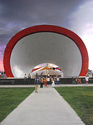
- Museo Espacio Interactivo La Rodadora
- Museo de Arte de Ciudad Juárez
- Museum of Archaeology El Chamizal
- Concorde Museum
Cultural Spaces
- Centro Cultural Paso del Norte (CCPN)
- INBA Exhibition Hall
- Municipal Arts Centre
- Civic Auditorium Municipal Benito Juárez
- Convention Center Four Centuries
- CIBELES Convention Centre
- Anita Convention Centre
- University Centre of Arts (UACJ-CUDA)
- Concha Acústica y explanada de la Plaza de la Mexicanidad
Parks, squares and recreational centers

- Federal Public Park El Chamizal
- Plaza Juan Gabriel
- Sports ComplexXXI
- East Sports Complex
- Parque Hacienda Universidad (Located in front of UTCJ)
- Parque Central Hermanos Escobar (Divided in two sections by the Federal Highway 45: Parque Central Poniente and Parque Central Oriente)
- Borunda Park
- X-tremo Park
- DIF Park
- Bertha Chiu Park
- Recreational Aquatic World Anita - Fun Park Anita New Adventure
- Recreation DIF
- Recreational Las Fuentes
- Recreational and Zoo San Jorge
- Recreative Dunas Campestre (Located in the town of Samalayuca).
- Parque Villas de Salvárcar
- Oasis Park of Santa Teresa
- Rio grande mall
- Plaza Benito Juárez
- Plaza de Armas
- Torres del Sur Park
- Plaza de la Mexicanidad (Also called Plaza de la X, for the monument located inside it).
- Plaza Misión de Guadalupe
- Plaza Cervantina
- Plaza del Periodista
- Plaza de las Fuentes Danzantes (Located in the Bertha Chiu Corridor)
- Medals of Samalayuca
- Samalayuca Archaeological Zone
- Memorial del Campo Algodonero
- Los Arenales (also called Loma Colorada, located in the town of San Agustín)
- Trepachanga Natural Park (Located in the Sierra de Juárez)
Monuments

- Monument to Benito Juárez (First icon of the city, because it bears its name in honor of this; it is also the most important monument in the country dedicated to the "Benemer of the Americas")
- Monument to Mexicanity (Metal sculpture, also called the "X" of Sebastian in honor of its sculptor; it is located inside its homonymous square)
- Umbral del Millennium (Metal sculpture, also called Puerta de Juárez, located at the entrance to the city)
- Arc de Triomphe (Réplica located in the suburb of Champs-Elysées, in the Golden Zone)
- Mission of Our Lady of Guadalupe
- Macrobandera de Ciudad Juárez (Also called Megabandera or monumental flag of Juárez, one of the first in the country)
- The indomitable (also called the indomitable of Ciudad Juárez, located in the chamizal)
- Monument to "Ser Fronterizo" (also known as a monument to pubic transport) directed the employees of the maquiladora industry of Ciudad Juárez.
Religious sites
Universal Help Center. Av. Tecnológico corner with Teófilo Borunda, neighborhood Iglesias party.
- Ciudad Juárez Cathedral
- Mission of Our Lady of Guadalupe (Considered the oldest building in the metropolitan area, founded in 1659)
- The Point; site used by Pope Francis to offer a mass mass in his visit to the city, which consists of a great altar, temple and the Migrants' Cross, located just on the banks of the Rio Bravo, which was blessed by His Holiness.
- Our Lady of Refuge Parish
- Our Lady of Hope Parish
- Santa Maria de la Montaña parish
- Temple of San Lorenzo
- Hermitage of San Lorenzo (Located outside the urban stain, on the Federal Highway 45)
- Parish of the Sacred Heart of Jesus
- Parish of Saint Teresa of Jesus
- Parish of San José
- Parish The Lord of Mercy
- Parish Jesus El Salvador
- Parish San Judas Tadeo
- Parish Our Lady of Carmen
- Parish Saint Philip of Jesus
- Conciliar Seminar of Ciudad Juárez
- Mexican Martyrs Parish
- Our Lady of Peace Parish
- Parish Christ King
- Parish Saint Vincent de Paul
- Parish The Transfiguration of the Lord
- Parish Twelve Apostles
- Parish The Holy Family
- Parish Santa Cecilia
- Centro Familiar Cristiano Sol de Justicia
- Centro Cristiano Comunidad Olivo
Sports venues
- Benito Juárez Olympic Stadium (F.C. Juarez and Indios UACJ, of the disappeared Indios de Juárez and Cobras de Juárez)
- Estadio Juárez Vive (Indian Sede of Cd. Juárez)
- Estadio Carta Blanca
- Stadium 20 November
- University gymnasium (UACJ)
- Gymnasium of the College of the State of Chihuahua (COBACH)
- Club Campestre de Ciudad Juárez
- Deportivo D' Martlub
- Plaza de Toros Alberto Balderas
- Cannzo Charro Adolfo López Mateos
- Sports Unit East CenturyXXI
- University Sports Unit (UACJ)
Gallery

Museum of the Revolution on the Border, formerly called the Museum of the Ex-Aduana.

Meds of Samalayuca, a few kilometres south of the city.
Concha acoustics located inside the Plaza de la Mexicanidad.

Museo Espacio Interactivo La Rodadora.

Some of the various animals on display in the Central Park.

Panoramic Central Park Poniente.


Guinness World Record
Ciudad Juárez holds the Guinness record for the largest astronomy class, which was achieved in the Samalayuca dunes in October 2011 with 458 telescopes and more than 2,000 attendees.
It also holds a second Guinness Record for gathering the largest amount of roast meat in the world. He obtained it in August 2017, when more than 500 grillers gathered in the Plaza de la Mexicanidad to roast 6 tons of meat.
In September 2018, they seek a third and fourth record in the Guinness record as the largest sign and the largest invitation in the world to read the Bible, respectively, due to a message that occupies 3000 square meters on the hill of & #34;the bible" (as it is known in Ciudad Juárez), which says "the bible is the truth, read it", which was written on rocks painted with lime, salt and water to avoid contaminating in the year 1987.
Education
Ciudad Juárez has many public and private educational institutions; for all levels given its population mainly of school age;
- Higher secondary education
- CEPU Pre-University Studies Centre
- College of Scientific and Technological Studies of the State of Chihuahua (CECyT)
- Centro de Bachillerato Tecnológico Industrial y de Servicios (CBTIS) Planteles 114, 128, 269, 270
- Centro de Estudios Tecnológico Industrial y de Servicios (CETIS) Plantel 61
- Colegio de Bachilleres del Estado de Chihuahua (COBACH) Plants 5, 6, 7, 9, 11, 16, 19, 23 and SEA.
- Ciudad Juárez Central Preparatory School (EPCCJ)
- Colegio Nacional de Educación Profesional Técnica (CONALEP) Planteles Juárez 1, 2, 3
- Centro de Estudios Tecnológico de Ciudad Juárez (CETCJ) Planteles Juárez 1, 2, 3
- Centro de Bachillerato Zaragoza (CBZ).
- Polytechnic Institute of the Border
- Special Cultural Campus Raza
- Higher education
- Public universities
- Universidad Autónoma de Ciudad Juárez (UACJ) - Institutos IADA, IIT, ICSA and ICB - Ciudad Universitaria (UACJ-CU) - Multidisciplinary divisions: Campus Nuevo Casas Grandes (UACJ-NCG), Campus Cuauhtémoc (UACJ-SC), Unit of Historical and Social Studies Chihuahua, Chih. (UACJ-UEHS)
- Instituto Tecnológico de Ciudad Juárez (ITCJ) - ITCJ Campus I - ITCJ Campus II University City
- Universidad Autónoma de Chihuahua Campus Ciudad Juárez (UACH)
- Universidad Tecnológica de Ciudad Juárez (UTCJ)
- Universidad Tecnológica Paso del Norte (UTPN)
- Normal Superior José E. Medrano
- Private universities
- Instituto Tecnológico y de Estudios Superiores de Monterrey Campus Ciudad Juárez (ITESM)
- Universidad Tec Millennium Campus Ciudad Juárez (Tec Millennium)
- Northeast American University Ciudad Juárez (UANE)
- Instituto Teresiano de Estudios Superiores (ITES)
- Universidad Interamericano del Norte Campus Ciudad Juárez (UIN)
- Universidad Regional del Norte Campus Ciudad Juárez (URN)
- Universidad Autónoma de Durango Campus Ciudad Juárez (UAD)
- Centro de Estudios Superiores del Norte (CESN)
- Centro Universitario de Ciudad Juárez (CU)
- Universidad Cultural Campus Ciudad Juárez (UC)
- Instituto de Estudios Superiores Adela de Cornejo
- Polytechnic Institute of the Border
- Instituto Superior de Ciencias de Ciudad Juárez (ISCCJ)
Hospitals
- Hospital Ángeles Ciudad Juárez S.A. de C.V.: Tomás Fernández 9371, Campos Eliseos.
- Hospital Star Médica: Paseo de la Victoria and Teófilo Borunda 4370, Partido Iglesias.
- Hospital Poliplaza Médica: Pedro Rosales de León 7510, Seminar.
- Family Hospital (FEMAP): Avenida Malecón 788, Colonia Centro.
- Instituto Chihuahuense de la Salud (ICHISAL): Paseo Triunfo de la República 2401, Partido M Doblado.
- Centro Médico de Especialidades De Cd Juárez S.A de C.V: Las Américas 201, Margaritas.
- Hospital Médica Sur de Ciudad Juárez s. de R.L de C.V: Ejército Nacional 6325, Los Portales.
- Hospital General del IMSS n.o 66: Fracc., Calle Ramón Rayón, Calle Eduarda Barbachano 951,
- Hospital General del IMSS n.o 35: Valentín Fuentes 2582, Casas Grandes Infonavit.
- Hospital General del IMSS no 6: Enveloping Ring Pronaf 3970, Zona Pronaf.
- Civil Pensions of the State of Chihuahua, Ciudad Juárez Delegation.
- ISSSTE General Hospital: Pronaf Envelore No. 4, Ana Elena Auza.
Transportation
Audience:
- Juarez lines
- Line 2 Lazarus
- Line East West
- Valle de Juárez (Porvenir, San Francisco, Villarreal and Riveras)
- University line
- Line 1-A (Morelos, Express and Unitec)
- Line 1-B
- Line 2-B
- Line 3-A
- Line 3-B
- Line 5-A
- Line 5-B (and its branchl prémium)
- Line 7
- Line 8-A
- Line 8-B
- Line 10
- South West Line
- Juárez-Zaragoza (and its Villarreal branch)
- Juárez-Airport Line
- United Permissionary Line (Lomas)
- Juarez-Bus Oasis Line
- Plus Interdependent Line
- Eco Vive-Bus
- Taxi
Private:
- Uber
- Kawi-Driver
- Cabify
- DIDI
- InDriver
Foreigner:
- Mexico bus (service plus)
- Mexican bus (vip service)
- Bus in the region
- Transportation Chihuahuenses (selected service)
- Futura (select service)
- Elite
- Quick Cuauhtémoc
- Red of the High
- Guadiana Valley
- Greyhound
- Transportation North (Senda Diamante)
- Limousines de México
Roads
Ciudad Juárez is connected to the rest of the country by two main highways:
 Federal Road 2.
 Federal highway 45.
Federal highway 2 is the axis of the northern border that begins in the city of Tijuana, Baja California and concludes in its first section in El Porvenir, Chihuahua. This highway connects Ciudad Juárez, in addition to these towns, with Nuevo Casas Grandes, Janos and Puerto Palomas to the west, and San Agustín Valdivia, Guadalupe, Práxedis G. Guerrero and El Porvenír to the southeast. This highway is located in the southern part of the urban area, originally it did not enter it, however population growth has integrated it into the city, it intersects with Federal Highway 45 in the formerly called "Glorieta de Cuatro Caminos& #3. 4; at the entrance of the city. Óscar Flores Boulevard in Ciudad Juárez receives the common name of "Carretera a Casas Grandes" because it was the exit of the city towards this highway.
Federal Highway 45 is the main communication route between Ciudad Juárez and the state of Chihuahua and the rest of the country. One of its ends is in this city and continues south to the city of Ixmiquilpan, Hidalgo; it unites Ciudad Juárez with the state capital, Chihuahua, as well as closer towns such as Samalayuca and Villa Ahumada, whose commercial exchange with Ciudad Juárez is intense.

International crossings

In the urban area:
- Puente Internacional Paso del Norte / El Paso Paso del Norte (PDN) Port of Entry. Located in the historic center of the city, it links Juárez Avenue in Juarez, with El Paso Street in El Paso; it has a sense of circulation only from Mexico to the United States.
- International Bridge Reform / El Paso Stanton Street Port of Entry. Also located in the historic center of the city, it links Lerdo Avenue in Juarez with Stanton Street in El Paso, its sense of circulation is only from the United States to Mexico, being the counterpart of the Northern Step.
- International Cordova Bridge of the Americas / El Paso Bridge Of The Americas (BOTA) Port of Entry, known as the Free Bridge and considered one of the most important international crossings in Mexico/U. border and in the world. Located in El Chamizal, it connects Abraham Lincoln Avenue in Juarez, with Interstate 110 in El Paso, and connects with the important interstate 10 from East to West (cost to coast).
- International bridge Zaragoza / El Paso Ysleta Port of Entry. Une la Avenida Waterfill en Juárez con la Avenida Zaragoza en El Paso, enspecific une los suburbios de Zaragoza e Ysleta, conurbados con Ciudad Juárez y El Paso, respectively.
- Cruce Internacional San Jerónimo / Santa Teresa Port of Entry, 17 km west of the city out of the urban spot. It is the only international crossing that connects the municipality of Juárez to the state of New Mexico, with the county of Doña Ana, making it easier to cross the United States of travelers from outside the city, such as the city of Chihuahua or the city of Nuevo Casas Grandes, avoiding having to travel through the busy arteries of the city.
In the towns of the state of Chihuahua near Ciudad Juárez, there are five more official border crossings, which are:
- International Doctor Porfirio Parra / Tornillo Port of Entry, also known as Caseta, 25 km east of the city; it unites the population of Doctor Porfirio Parra (La Caseta), municipality of Guadalupe, with the town of Tornillo, county of El Paso, Texas.
- International Bridge Porvenir / Fort Hancock Port of Entry, 69 km east of the city; it unites the town of El Porvernir, municipality of Práxedis G. Guerrero, with the town of Fort Hancock, county of Hudspeth, Texas.
- Cruce Internacional Palomas / Columbus New Mexico Port of Entry, 133 km west of the city; it unites the town of Puerto Palomas, municipality of Ascension, with the town of Columbus, county of Luna, New Mexico.
- Cruce Internacional El Berrendo / Antelope Wells Port of Entry, 284 km west of the city; it unites the town of El Berrendo, municipality of Janos, with the population of Antelope Wells, county of Hidalgo, New Mexico.
- International Bridge Ojinaga / Presidio Texas Port of Entry, 405 km southeast of the city, it unites the city of Ojinaga, Ojinaga municipality, with the city of Presidio, Presidio County, Texas.
Railway
- To the south there are two railway lines, one that leads to the city of Chihuahua, and another that leads to the city of Nuevo Casas Grandes.
- To the north there are two railway lines crossing the Rio Bravo and communicating the city with the United States.
Airport
The Abraham González International Airport is the air terminal that serves Ciudad Juárez, it is located in the southern part of the city on the Pan-American Highway, where national airlines operate: Aeroméxico, Aeroméxico Connect, Interjet, Volaris and Viva Aerobus, which offer direct flights to Chihuahua, Monterrey, Guadalajara, Mexico City, Puerto Vallarta, Cancun, León, Hermosillo and Tijuana.
BRT Transportation System
Inauguration
Finally, and thanks to the planning, control and administration of the Municipal Government in conjunction with the Juárez Transport Integrator company (INTRA) and some other municipal agencies, at the end of 2013 the now officially called ViveBús Ciudad Juárez was inaugurated. Specifically on November 30. That day, according to various media, began a new part of the history of Ciudad Juárez, since for the first time a public transport service would be implemented that would provide the quality and efficiency that Juárez citizens had deserved for decades.
Features
Among the 5 routes or lines contemplated within the ViveBús Ciudad Juárez, the first one is currently finished and in operation. This first line is officially called Presidencia-Tierra Nueva, which has 34 stations, 10 of them double; distributed along the north and south of the city, starting on Francisco Villa Avenue, following its path towards the North-South Road Axis, at the intersection with Blvd. Zaragoza it turns east, continues along the mentioned boulevard continuing the road, until it ends at the intersection with Av. Independencia and overpass of Federal Highway 2.
Transshipment
Since the 19th century there was a transportation system specialized in transporting passengers from Juárez to El Paso, or at that time (1881) being El Paso del Norte, to cross the Rio Grande. In the following years, once the two cities were divided, the first binational transportation system using tram would be created. That transportation system would continue to function successfully until the 1970s. However, it was in 1974 that this tram transportation system would become obsolete.
In more recent years, the need to once again create a transportation system specialized in moving passengers from one city to another was seen, due to the rapid demographic growth present in both cities, and also, due to the present difficulties to cross to the other country, such as long waiting times, among other aspects.
This is how binational transportation is reborn in the border region. This new system is called Transborde, which has a fleet of recent model trucks, and these, in turn, have climate, among other benefits. These units have a capacity of up to 80 passengers. Obviously, this transport system has a cost, however it is currently questioned whether the passage of passengers would continue to have a cost, since the operation of the international bridges leaves the Municipality of El Paso between nine and ten million dollars. Likewise, it is defining what type of intelligent document the users of these buses in the 2 cities would present to identify themselves.
Thanks to this transport system, 1,200 to 1,500 vehicles per hour have been allowed to pass through with a speed of 40 to 50 miles for the same amount of time.
Sports
- Football teams published in the Herald of Ciudad Juárez, Chihuahua.
- Bravos de Juárez of the First Division of Mexico
- Bravas de Juárez of Mexico's First Women's Division.
- Cd Soles. Juarez of the Third Division of Mexico.
- Club livescore of the Third Division of Mexico.
- The Cd Tribe. Juarez of the Third Division of Mexico.
- Baseball equipment
- Juarez Indians of the Chihuahua State League.
- Basketball equipment
- Citizen Juarez Indians in the National League of Professional Basketball of Mexico and the Chihuahua State Basketball League.
- Tarahumaras de Cd. Juarez at the Chihuahua State Basketball League.
- Natives of Cd. Juarez at the Chihuahua State Basketball League.
- American Football Teams
- Heads of Ciudad Juárez at the Mexican Professional American Football League.
- Local teams of Ciclismo de Ciudad Juárez, Chihuahua according to the data released by the social network and GPS,Strava.
- Chupacabras 100 K.M. (Inactive 2014)
- Intense Cycling Team.
- Gosth Cyclery Team.
- Bandits Cycling Team.
- Saving.
- Rhinos Lima Bike Team.
- Husbands
- Mozketeros.
- Spartans M.T.B. Juarez.
- TPI Composites.
- Conejos Juárez M.T.B.
- Caraxillos Cycling Team.
- Zopilotes Team.
- JRZ BIKE RUNNERS.
- Wong Tacx Riders
- Crazy Cat Cyclery.
- Soles de Ciudad Juárez (infantil)
- Stadiums
- UACJ Olympic Stadium "Benito Juárez" (Multi-Us) (FC Juárez); capacity: 19 703 people
- Estadio Juárez (Bysbol) Capacity: 15000 people
- Stadium White Charter (Bysbol) Capacity: 5000 people
- Estadio Jaime Canales Lira (Bysbol) Capacity: 4500 people
- Stadium 20 November (Football) (Soles de Cd. Juárez), (Club de Fútbol Cobras), (La Tribu de Cd. Juárez); capacity: 5000 people.
- Campo Guillermo Chucus Olascoaga (American football); capacity: 2000 people.
- Municipal Committee on Sport Fishing Cd. Juarez.
- Adventure in Dunas. (Festival held annually in the Dunes of Samalayuca, in which competencies of various extreme sports, for example motocross and sandboard, among many others) are carried out.
- Sport fishing
- Carrera Chupacabras 100 km.
- D'Martlub Sports Field
- (2011) See of the X Pan American Volleyball Cup. Winner: Brazil
 Brazil
 - (2012) See of the XI Pan American Volleyball Cup. Winner:
 United States
Religion
The population is largely Catholic, with a growing number of evangelical Protestants (including Reformed Christians, Baptists, Presbyterians, Pentecostals, Charismatics, and Methodists).
In addition, about 9 percent belong to other groups within Christianity that do not consider themselves Protestants due to their denial of the doctrine of the Trinity: Jehovah's Witnesses and Oneness Pentecostals as exemplars, or in the case of The Church of Jesus Christ Of Latter Day Saints, base your beliefs on a literal restoration.

The city is home to several important religious centers in Mexico and Latin America for different faith communities. For the Catholic Church, the city is the seat of the Diocese of Ciudad Juárez, which was created in 1957 with territory taken from the Archdiocese of Chihuahua of which it is a suffragan. At present, the Diocese is made up of the municipalities of Ahumada, Guadalupe, Práxedis G. Guerrero and Juárez, with its headquarters in the Ecclesiastical Government House. Since 2014 its bishop is José Guadalupe Torres Campos. For the Reformed churches, the city is the headquarters of the Iglesia Cristiana Gracia Soberana de Cd. Juárez (belonging to the Sovereign Grace Ministries group of churches). For the churches within the Charismatic Movement, the city is the headquarters of the Vino Nuevo Christian Center (considered one of the most influential neo-Pentecostal churches in the Mexican Republic). Likewise, for the Church of Jesus Christ of the Saints of the Last Days (Mormons), the city is home to the Temple of Ciudad Juárez.
Crime and security
Criminal activity in the Ciudad Juárez metropolitan area has increased dramatically since the rise of the maquiladoras and especially since the establishment of the North American Free Trade Agreement in 1994, two factors that attracted so much international trade like many young women and their families in search of better job opportunities and more economically favorable. Violence against women has increased a lot in the last twenty years, since the early nineties there have been approximately six hundred femicides and at least three thousand women disappeared. The escalation of violence between warring clans, the Sinaloa Cartel and the Juárez Cartel, have raised the level of violence since the first decade of the XXI century.
The Ciudad Juárez Police Department had a number of approximately eight hundred members as of September 2008, after reducing the number by approximately one-third for various reasons, although the goal was to double the number of members. Citizens threatened to take action on the matter to reduce the number of violent acts, which is why the government expressed its fears about the appearance of phenomena such as citizen patrols that would only contribute to increasing instability and violence. In response to the increase in violence, increased the presence of the Mexican Armed Forces and the Federal Police. In March 2009 there were at least 4,500 soldiers and federal police officers. In August 2009 this number was increased to 7,500 Federal Police. highest in the world, ahead of Caracas and New Orleans (second and third) by more than 25%. The rate was 130 murders per 100,000 inhabitants. Journalist Charles Bowden, in an August 2008 article in GQ magazine, wrote that "many factors, including drug violence, government corruption, and poverty, have led to a messy and spiritless atmosphere that engulfs the entire city.
Drug Cartel Violence
More than 1,400 murders occurred in 2008 and more than 3,500 drug-related deaths in the same period in 2010. The population of Ciudad Juárez has had to change their daily routine and many try to stay at home at night. Public life is almost paralyzed by the fear of being kidnapped or hit by a stray bullet. On February 20, 2009, the United States Department of State sent out an alert stating that "Mexican authorities report that more than eighteen hundred people have been murdered since January 2008." On March 12, 2009 Police found at least seven partially buried bodies on the outskirts of the city near the US-Mexico border. Five heads were found in ice boxes with notes addressed to rival drug clans.
In September 2009, eighteen patients from a drug rehabilitation center called “El Aliviane” were massacred in a brawl between rival gangs, the victims were lined up in a hallway and shot.
Plagued by corruption and the murder of many of its officers, the government fights to maintain the police force while many leave the service for fear of being potential targets. Much of the violence in the city stems from the gang violence, as the cartels hire gangs as hit men, especially the gangs known as Los Aztecas and Los Mexicles.[citation needed] Arturo Sandoval, spokesman for The Chihuahua State Attorney General's Office recognized that in February 2011 "the worst violence of the year" was taking place, with 53 people murdered in 72 hours.
By the end of 2012, organized crime-related homicides had dropped by 92%. In most months of 2013, there was also a significant reduction in the number of intentional homicides, going from registering approximately 10 executions a day during the bloody period of 2008-2012, to registering the same number of homicides during the course of of weeks, and even months, approximately.[citation needed]
Femicides
Violence against women has increased a lot in the last twenty years, since the beginning of the nineties there have been approximately six hundred femicides and at least three thousand disappeared women. In 2010 the number of murders of both sexes was 3,100. Their bodies are often thrown into landfills or lots. Additionally, organizations at the local level have reported that four hundred more remain unaccounted for. Despite local pressure to catch the murderers and having located suspects, the problem is not resolved. These associations, mostly civilians, have been increasing significantly, some of them are started by the same relatives of the victims. Due to violence against women, multiple support associations have been created, among the most prominent are: Caminantes Unidos A.C., Casa de la Sal, Casa Hogar del Refugio, Casa Hogar las Mercedes and Católicas por el Derecho a Decidir, A.C.
Decrease in crime rates
Since mid-2012, and throughout 2013, there was a drastic drop in crime rates, mainly in the matter of homicides, kidnappings, and extortion. Statistically, the city went from registering, in its most violent streak, more than 50 homicides in just 72 hours, to not registering any homicides for periods of approximately a week. Similarly, regarding monthly records, the city went from registering again in its most violent streak, more than 200 homicides per month, to registering in its safest season, only 38 homicides per month. With these data, it was possible to affirm that homicides related to organized crime had been reduced by 80%. Likewise, considerable decreases have been noted in other criminal areas, such as kidnapping and extortion, reducing by 70%, robberies with violence in 40% and the same without violence in 90%. These data point to a stark contrast in the crime rates of the bloodiest year, and the safest; 2010 and 2013, respectively.

Although these figures that mark a noticeable decrease in violence are not the best; for the violent season that the city experienced during the years from 2008 to 2012 are a sign of hope for the people of Juarez, and perhaps, a respite, since according to the citizens, it is an indication that in a near future, the 'Ciudad Juárez' in which they lived with tranquility and happiness. According to various sources, this notable improvement in border security can be related to the strict measures to combat security implemented by the three levels of government, which were successful. However, some media speculate that the decrease in crime rates is not due entirely to the actions carried out jointly by the three spheres of government, but to the control of the square obtained by some drug cartel.
Thanks to the improvement in security and the success obtained by the actions implemented against violence, the city has been recognized both nationally and internationally, for example, in December 2013, the United Nations Organization highlighted the low of violence in the city, similarly, state governments have considered applying the security strategy implemented in Juárez to combat drug cartels, especially in the state of Michoacán, which since 2013 has been registering a significant increase in violence. Likewise, recently, the city managed to rank 37th among the most violent cities on the planet, in which, in one year, it dropped 18 steps on the table, going from 19th to 37th place in the ranking. ranking carried out by the Citizen Council for Public Safety and Criminal Justice Civil Association, with the universal monitoring of the behavior of homicides. The annual study of said civil association indicates that Juárez ranked first consecutively in the years 2008, 2009 and 2010, it moved to second place in 2011 and to position 19 in the 2012 report, while in 2013 it ranked 37th place among the 50 most violent locations in the world. The study positions the city of San Pedro Sula, in Honduras, as the most violent among the 50, for the third consecutive year, with a rate of 187 homicides per hundred thousand inhabitants against a rate of 37.59 homicides per hundred thousand inhabitants, of Juárez.
Media
Internet
Ciudad Juárez has several pages on social networks that report on what is happening in the community, such as
- daily.mx Real-time news. Local information, politics, entertainment, sports, economy, health, national and international news and the most important events in the world.
- ILOVE JUAREZ publishes stories, photos, videos and positive news of the city.
- Love JRZ
- Ciudad Juárez
- I live in Juarez and I am happy
- Visit Juárez Tourist Information and Meetings
- Netnoticias.mx
- The Polaka
- Herald of Juarez
- informant.mx
Press
Local newspapers are published in the city, such as El Diario, El Mexicano, Juárez Hoy and PM. The newspaper Norte de Ciudad Juárez closed its print edition on April 2 after the murder of journalist Miroslava Breach Velducea, and subsequently closed its digital edition 3 days later.
Television
On June 12, 2009, the high-power channels of El Paso, Texas, switched from analog to digital. On July 14, 2015, the high-power channels of Cd. Juárez, Chihuahua, switched from analog to digital.
Digital terrestrial television
As of November 16, 2021, there are 62 digital terrestrial television channels.
| Canal | Acronyms | Resolution | Chain | City |
|---|---|---|---|---|
| 1.1 | XHCJE-TDT | HD 1080i | Aztec One | Ciudad Juárez |
| 1.2 | XHCJE-TDT | SD 480i | DNA 40 | Ciudad Juárez |
| 2.1 | XEPM-TDT | HD 1080i | The Stars | Ciudad Juárez |
| 2.2 | XEPM-TDT | HD 720p | The Stars The Step | Ciudad Juárez |
| 3.1 | XHCTCJ-TDT | HD 1080i | Image | Ciudad Juárez |
| 3.4 | XHCTCJ-TDT | SD 480i | Multicast image | Ciudad Juárez |
| 4.1 | KDBC-DT | HD 1080i | CBS | The Pass |
| 4.2 | KDBC-DT2 | HD 720p | TBD / MyNetwork TV | The Pass |
| 4.3 | KDBC-DT3 | SD 480i | MeTV | The Pass |
| 4.4 | KDBC-DT3 | SD 480i | Dabl | The Pass |
| 5.1 | XHJUB-TDT | HD 1080i | Channel 5 | Ciudad Juárez |
| 6.1 | XHMTCH-TDT | HD 1080i | Multimedies | Ciudad Juárez |
| 6.2 | XHMTCH-TDT | SD 480i / Mpeg4 | Millennium Television | Ciudad Juárez |
| 6.3 | XHMTCH-TDT | SD 480i | Shopping | Ciudad Juárez |
| 6.4 | XHMTCH-TDT | SD 480i | ABC Televisión / Canal 28 de Chihuahua | Ciudad Juárez |
| 7.1 | KVIA-DT | HD 720p | ABC | The Pass |
| 7.2 | KVIA-DT2 | HD 1080i | The CW | The Pass |
| 7.3 | KVIA-DT3 | SD 480i | ION | The Pass |
| 7.4 | KVIA-DT4 | SD 480i | Azteca America | The Pass |
| 8.1 | XHJCI-TDT | HD 1080i | Televisa Ciudad Juárez | Ciudad Juárez |
| 8.2 | XHJCI-TDT | SD 480i | Forum TV | Ciudad Juárez |
| 9.1 | KTSM-DT | HD 1080i | NBC | The Pass |
| 9.2 | KTSM-DT2 | SD 480i | Star TV | The Pass |
| 9.3 | KTSM-DT3 | SD 480i | Court TV Mystery | The Pass |
| 9.4 | KTSM-DT4 | SD 480i | Laff | The Pass |
| 10.1 | XHJUB-TDT | SD 480i | NU9VE | Ciudad Juárez |
| 13.1 | KCOS-DT | HD 1080i | PBS | The Pass |
| 13.2 | KCOS-DT2 | SD 480i | El Paso Community College | The Pass |
| 13.3 | KCOS-DT3 | SD 480i | Create | The Pass |
| 13.4 | KCOS-DT4 | SD 480i | City 15 | The Pass |
| 14.1 | KFOX-DT | HD 720p | FOX | The Pass |
| 14.2 | KFOX-DT2 | SD 480i | Comet | The Pass |
| 14.3 | KFOX-DT3 | SD 480i | Charge! | The Pass |
| 14.4 | KFOX-DT4 | SD 480i | Stadium | The Pass |
| 20.1 | XHCJH-TDT | HD 1080i | Aztec 7 | Ciudad Juárez |
| 20.2 | XHCJH-TDT | SD 480i | A+ | Ciudad Juárez |
| 25.1 | K27OJ-D DT | HD 1080i | Voice and Vision TV | The Pass |
| 25.2 | K27OJ-D DT2 | SD 480i | Teleritmo | The Pass |
| 25.3 | K27OJ-D DT3 | SD 480i | CCBM WBCC | The Pass |
| 26.1 | KINT-DT | HD 1080i | Univision | The Pass |
| 26.2 | KINT-DT2 | SD 480i | Grit | The Pass |
| 26.3 | KINT-DT3 | SD 480i | LATV | The Pass |
| 26.4 | KINT-DT4 | SD 480i | Bounce | The Pass |
| 26.5 | KINT-DT5 | SD 480i | Court TV | The Pass |
| 38.1 | KSCE | HD 720p | Life | The Pass |
| 38.2 | KSCE-DT2 | HD 1080p | Life | The Pass |
| 38.3 | KSCE-DT2 | HD 720p | End of Times | The Pass |
| 38.4 | KSCE-DT3 | SD 480p | Maxed Life | The Pass |
| 38.5 | KSCE-DT4 | SD 480i | Bible | The Pass |
| 44.1 | XHIJ-TDT | HD 1080i | The News Channel | Ciudad Juárez |
| 44.2 | XHIJ-TDT | SD 480i | The News Channel -2 Hours | Ciudad Juárez |
| 44.3 | XHIJ-TDT | SD 480i | Learn at Casa | Ciudad Juárez |
| 44.4 | XHIJ-TDT | SD 480i | Intermedia Television | Ciudad Juárez |
| 48.1 | KTDO-DT | HD 1080i | Telemundo | The Crosses |
| 48.2 | KTDO-DT2 | SD 480i | Telexitos | The Crosses |
| 48.3 | KTDO-DT2 | SD 480i | LX | The Crosses |
| 50.1 | XEJ-TDT | HD 1080i | XEJ Canal 50 /Canal Once | Ciudad Juárez |
| 50.2 | XEJ-TDT | HD 1080i | Eleven Girls and Children | Ciudad Juárez |
| 65.1 | KTFN-DT | HD 1080i | Uni | The Pass |
| 65.2 | KTFN-DT | SD 480i | Justice Network | The Pass |
| 65.3 | KTFN-DT | SD 480i | Quest | The Pass |
| 65.4 | KTFN-DT | SD 480i | Wellness TV | The Pass |
Pay TV
- Izzi
- SKY Mexico (with a subdivision that is VeTv)
- Dish Mexico
- Totalplay
Radius
In Ciudad Juárez, 54 radio signals are received, of which 29 are frequency modulated, and 25 are amplitude modulated. Some of them originate in the United States of America.
There are also 8 internet radio stations.
- Two radius - 64 kbps. Transmit rock, metal, ska and reggae, local bands.
- Quinmedia Online - 112 kbps. Transmit Christian music.
- Your VIP radio - 64 kbps. Transmit pop music and popular music.
- Livox Radio - Transmit rock, pop, jazz and local talent.
- Radio Fusion - Transmits rock, heavy metal, power metal and black metal, local bands.
- Prendete Radio - 320 kbps. Transmit pop, various genres, local bands.
- Indie broadcasts independent rock, ska, reggae, electronics, jazz fusion and funk.
- Radio No Name 103.9 Online - Transmits music from around the world, of all musical genres and of all languages existing through the frequency 103.9 FM of the colony match rosemary and also by the web.
Municipal presidents
See Annex: Municipal Presidents of Ciudad Juárez
Sister cities
Ciudad Juárez has established twinning agreements with the following cities:
 Jerez de la Frontera, Spain (1998)
- El Paso (2002)
 Mexico City (2004)
- Tijuana, Mexico (2006).
- Chapala, Mexico (2010)
- Boca del Rio, Mexico (2012).
- Tequila, Mexico (2013).
- Monterrey, Mexico (2014).
- Saltillo, Mexico (2014).
- Heroica Matamoros, Mexico (2014).
- Reynosa, Mexico (2014).
- Ciudad Benito Juárez, Mexico (2014).
- Mexico Gómez Palacio (2014)
- Ciudad Lerdo, Mexico (2014).
- Culiacán, Mexico (2014).
- Los Mochis, Mexico (2014).
- Chihuahua, Mexico (2014).
- Tepic, Mexico (2014).
- Mazatlan, Mexico (2014).
- Tecomán
- Juazeiro
- Chihuahua
- Puerto Peñasco
- New Big Houses
- Poza Rica
- San Diego
- Colton.
- The Crosses
- Zaragoza
 Berlin
 Havana
- Dallas
- Los Angeles
Agreements
- Morelia, Mexico (2017).
- Guadalajara, Mexico (2018)