
Jamestown (St. Helena)
Jamestown is a port and the capital of the British Overseas Territory of Saint Helena, Ascension and Tristan da Cunha, in the South Atlantic Ocean, Africa. It has a population of 630 inhabitants. It was founded in 1659 by the East India Company, being the second oldest of the British territories after Bermuda. It is surrounded by steep gorges.
Located on the northwest coast of Saint Helena Island, it is the main and historic settlement of the island. Being a port, it has facilities for unloading goods delivered to the island, and is the center of the island's road network and communications network (mainly radio).
History and characteristics
.jpg)
Jamestown was founded in 1659 by the British East India Company and named after James, Duke of York, later King James II of England. A fortress, originally called Castillo de San Juan, was completed within a month and new houses were built beyond the valley. With the restoration of the monarchy in 1660, the fort was renamed Fort James, the town as Jamestown, and the valley as James Valley. Between January and May 1673 the Dutch East India Company forcibly took the island, before English reinforcements restored control. Since then, the city has been continuously inhabited by Englishmen and is a British domain.
The city is built on igneous rock in a small valley, located between 150 meter cliffs that are not suitable for construction. Therefore, the city is quite long, thin and densely populated, with very close-knit buildings and long, winding streets. The main one is about a mile long. Shrubs and trees decorate some of the street corners. The surrounding terrain is rough and steep, and rockfalls are common, sometimes damaging buildings. The city is commonly divided into lower and upper parts, depending on the altitude of the valley.
The town features some examples of Georgian-era British colonial architecture and is proposed as a UNESCO World Heritage Site. Many buildings are built from the local volcanic rock. St James's Church has existed since 1774 and is the oldest Anglican church in the Southern Hemisphere. Two other churches are notable in the city: the Church of San Juan (Anglican) and that of the Sacred Heart (Catholic), in the upper area. Jamestown has more than half of the island's listed buildings, a designation for buildings of historical or architectural merit. The town's most prominent landmark is Jacob's Ladder, a ladder with 699 steps, built in 1829 by the Saint Helena Railway Company connecting Jamestown to the garrison at Ladder Hill, still used today. At night it lights up and a measured race takes place every year, with people coming from different parts of the world.
Being the island's only port (and with the proposed airport due to be built by 2015) the town is the only entrance to the island for visitors, and can be especially busy with tourists coming from arriving cruise ships. The St. Helena Museum is located in Jamestown, being one of two museums on the island (the other being Longwood House). Near Jamestown is also the High Knoll Fort (in ruins) and further inland there are tourist attractions based on Napoleon Bonaparte's exile on the island, namely Longwood House, the Briars and his tomb. Another site of interest in the city is the Broadway House. Due to tourism on the island, the town has several hotels and restaurants, as well as pubs and several shops.
Population

The city's population has been declining along with the island's population, but also because the suburb of Half Tree Hollow has been growing. This suburb was built due to the lack of suitable space in Jamestown and its geology. In 2008 it had a population of 714, compared to a population of 884 in 1998. The town is no longer the largest settlement on the island, as Half Tree Hollow and San Pablo are slightly more populated.
Status
Jamestown is officially a town, a status granted by Queen Victoria in 1859, and its full name is 'James Town'. It is also one of the 8 boroughs (administrative divisions) of the island and extends northwards along the coast, including James Bay, Rupert Bay and Banks Valley Bay, as well as slightly inland along the valley. The small settlement of Haytown is located in Rupert Valley. This was a new planned city (although it did not grow as expected), created by Governor Hay in the 1860s.
Jamestown is the capital of both the island of Saint Helena and the British Overseas Territory of Saint Helena, Ascension and Tristan da Cunha. Although it has long been the capital of the island, Plantation House (the official residence of the Governor, built in 1792) and St. Paul's Cathedral (of Anglican worship, built in 1851) are located about 3 kilometers to the south, in Saint Paul's. However, the main administrative buildings of the island's public bodies are located in Jamestown, including El Castillo. One explanation for the location of the Governor's official residence is that the climate is less arid and the terrain lies further inland, compared to that of the James Valley.
Climate
Jamestown has an arid climate with constant temperatures throughout the year. Although the city has an arid climate, temperatures are moderated by the adjacent ocean. As a result, it rarely gets very hot in Jamestown. The temperature in the Jamestown area is about 5 degrees warmer than the rest of the island, due to the difference in altitude. The higher parts of the island are also wetter than the town, which is located on the drier coast and in a sheltered location. The surrounding waters can be very dangerous at times, and there is a small dike to protect the settlement.
| Month | Ene. | Feb. | Mar. | Open up. | May. | Jun. | Jul. | Ago. | Sep. | Oct. | Nov. | Dec. | Annual |
|---|---|---|---|---|---|---|---|---|---|---|---|---|---|
| Temp. max. abs. (°C) | 32 | 32 | 33 | 34 | 28 | 27 | 26 | 26 | 26 | 26 | 27 | 28 | 34 |
| Average temperature (°C) | 27 | 27 | 28 | 27 | 24 | 23 | 22 | 22 | 22 | 23 | 23 | 24 | 24 |
| Temp. medium (°C) | 21 | 21 | 22 | 21 | 19 | 18 | 17 | 17 | 17 | 18 | 18 | 19 | 19 |
| Temp. min. abs. (°C) | 17 | 19 | 19 | 17 | 16 | 16 | 14 | 15 | 14 | 16 | 17 | 16 | 14 |
| Total precipitation (mm) | 8 | 10 | 20 | 10 | 18 | 18 | 8 | 10 | 5 | 3 | 0 | 3 | 113 |
| Days of rain (≥ 1 mm) | 4 | 4 | 5 | 3 | 4 | 6 | 8 | 3 | 2 | 0.7 | 0 | 1 | 41 |
| Source: BBC Weather | |||||||||||||
Gallery
- Jamestown

View towards 1970
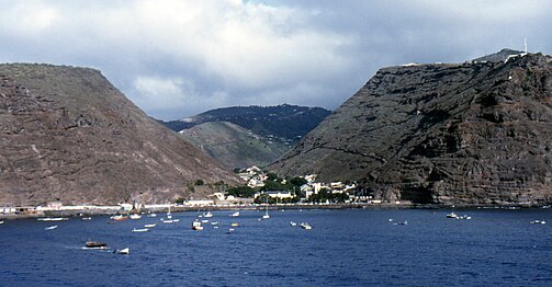
Another view from the sea

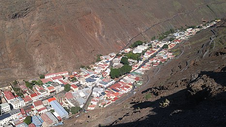
View from the Jacob's Ladder

Church of Saint James
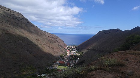
Jamestown seen from the south


Contenido relacionado
The baggin
Rwanda
Area (disambiguation)