
Iberian Peninsula
The Iberian Peninsula is located in the southwest of Europe; It is surrounded by the Mediterranean Sea and the Atlantic Ocean, joining the rest of the continent to the northeast. It is one of the three great peninsulas of southern Europe, together with the Italic and the Balkans, and measures approximately 596,740 km².[citation required] Traditionally, the border of the peninsula in the Pyrenean mountain range, although the isthmus is located on the straight line that joins the central point of the Bay of Biscay and Leon —between the respective coasts of the cities of Bayonne and Narbonne—, thus being included a southern strip of French territory south of the isthmus.
Two countries, Spain and Portugal, occupy almost the entire peninsular surface, as well as Andorra, the British territory of Gibraltar and, partially, the French departments of the Pyrenean area. Historically, the continental territory located "beyond" the Pyrenees has been called the "Iberian peninsula", "Iberia", "Hispanic peninsula" or "Hesperian peninsula". The expression "Iberian peninsula" was coined for the first time by the French geographer Jean-Baptiste Bory in his work Guide du voyageur en Espagne of the year 1823.
Etymology
The expression Iberian Peninsula is a modern term of French origin used in the 1823 geographical work On the physical description of Spain and Portugal by Jean-Baptiste Bory de Saint-Vincent.
«Les divisions établies par les hommes à la surface de la terre sont tellement sujettes au changement, que dans ce chapitre, consacré à la description physique de l'Espagne et du Portugal, nous n'emploierons que le moins possible de ces noms de royaumes, que le caprice des révolutions peut confond Le nom de Péninsule Ibérique nous semble plus convenable, et nous l'adopterons pour désigner cette partie de l'Europe»BORY, 1823)
Toponymy

Currently, in Spanish it receives the name "Iberian Peninsula", written in lower case. Different names of this geographical feature in other languages and dialects spoken to a greater or lesser extent in the territory would be "Peninsula Ibérica" (Portuguese, Galician, Asturian and Extremaduran), "Península Ibèrica" (Valencian/Catalan), "Iberian Peninsula" (English), "Péninsule ibérique" (French), "Peninsula Iberica" (Aragonese and Occitan) and "Iberian penintsula" (Basque).
In the past, historians and geographers of Greek culture, such as Herodotus, Strabo and Appian, called it "Iberia". Roman writers in turn gave it the name "Hispania".
Its name comes from the Íber river, probably the current Ebro, although it could also be another river in the province of Huelva, where very old texts mention an Iberus river and a town they call Iberians. Initially, in archaic Greece, the Greeks were able to call it "Hesperia", since Hesperia was described as the westernmost area of the Mediterranean; although it is not known with certainty if it refers to present-day Spain, Morocco or both. Later the Greeks would call it "Iberia".
Polybius, a Greek historian of the II century a. C. who lived for a time on the peninsula, writes:
It is called Iberia to the part that falls on Our Sea (Mediterranean), from the Heraklea columns. But the part that falls to the Great Sea or the Outer Sea (Atlantic), has no common name to all of it, because it has been recently recognized.Polibio
Strabo dedicates Book III to the Iberian Peninsula.
The first part of it (Europe) is, as we said, the West; that is, Iberia; this, in its largest extent, is not inhabitable, since almost all is covered with mountains, forests and plains of soil poorly and unequally watered.Strabon, Book III.
Appianus of Alexandria (II century), in his Roman History, writes:
The size of Iberia, now called Hispania instead of Iberia by some, is great and incredible to be a single country, whose extension is ten thousand stadiums and its length is equal to its width.Apiano, Roman history.
Historiography also refers to it with other words, depending on the historical context: «Celtaria», «Celtiberia», «Land of Tartessos», «Sefarad», «Al-Andalus», etc. Some scholars, such as Dámaso Alonso, considered that the name of the Hispanic Peninsula would be more appropriate.
Historical evolution

Iberia was the name given by the Greeks to the peninsula, although the part they knew best was the southern area of the eastern peninsula, around the Íber river. Hispania was the name used by the Romans to designate the Iberian Peninsula, possibly of Punic origin (see Origin of the name of Hispania).
After the Muslim conquest it received the name of al-Andalus, becoming part of the North African province of the Umayyad Caliphate (711 to 1492) to later become the Emirate of Córdoba and later the Caliphate of Córdoba independent of the Caliphate Abbasid. With the dissolution of the Caliphate of Córdoba in 1031, the territory was divided into the first Taifa kingdoms, a period followed by the Almoravids, the second Taifa kingdoms, the Almohads and the third Taifa kingdoms.
_Repertorio_Caminos_Espa%C3%B1a.jpg)
Later on, after the dynastic union of the crowns of Castile and Aragon and the conquests of Granada and most of the Kingdom of Navarra, the resulting territories began to be called Spain, for simplification among non-Spaniards, although the legal unification of all these kingdoms was not consolidated until the XVIII century, with the Bourbons.
Until late 17th century, early XVIII, all the peoples of the Iberian Peninsula considered themselves Spanish, as currently the various peoples of Scandinavia are considered Scandinavian, or those of the Balkan Peninsula are considered Balkans.[citation required] With difficulty the Portuguese felt compelled to stop calling themselves Spanish as well, so as not to be taken for Castilian, as the Castilianization of Spain developed. other kingdoms of ancient Hispania.
Due to the manifest historical, political and cultural impossibility of continuing to call the Portuguese "Spanish", without their being confused with Castilians by other peoples who ruled inside and outside the Hispanic peninsula Since then, the expression «Iberian» began to be used to designate the «two peoples» of the Hispanic peninsula, now preferably called by the neologism Iberian peninsula. This process was parallel and similar to the one that arose abroad of calling the Castilian language Spanish, made the only official language by the Spanish government, until they changed the official designation of the State, with the creation of the official name: Kingdom of Spain. in the XVIII century, and the change of the title of the kings of León, Castilla, Aragón, Sicily, etc. for the kings of Spain for symbolic purposes of administrative unification and for the new international presentation of the monarchy of the plateau.
Geography

The peninsula would be about 622,918 km², including about 40,000 km² corresponding to the southern part of the isthmus, but north of the Pyrenees, French territory. If that area is excluded, the area would amount to about 582,918 km².
Within its geographical limits are mainland Spain, continental Portugal, Andorra and Gibraltar, in addition to the aforementioned French southern strip. To the south, the peninsula is separated from Africa (Morocco and Algeria) by the Mediterranean Sea (which in this area is called the Alboran Sea) and the Atlantic Ocean, the Strait of Gibraltar being the limit between the two. The highest point is Mulhacén at an altitude of 3,478.6 m above sea level. The longest river is the Tagus, with a length of 1,007 km (731 km in Spain and 275 km in Portugal).
The Greek geographer Strabo, speaking of the Iberian Peninsula, compares it to a bull's skin:
Iberia... looks like a skin dyed in the sense of its west to east length and in the sense of its width of septhion at noon.Strange.

Due to its extension, the Iberian Peninsula would occupy, if it were reunited under the same State (as it was between 1580 and 1640, with the exception of Andorra), the 48th largest country in the world and by its population would rank number 24.
Geographic center
There is no scientific consensus on where the geographic center of the Iberian Peninsula is located. Rosario and the Hospital have been fighting for this recognition for centuries. However, more recently other studies have come out that would place the geographic center in the province of Toledo.
Topography
Its topography has as its main characteristic that most of its surface is configured as a plateau, with a slight slope to the west; This has an average height of six hundred meters above sea level; the coastline is rocky and with cliffs to the north, northeast, northwest and southeast, with most of the eastern and southern coastline being smoother.
Extreme Points

- Point further north: islet of Estaquín de Sigüelos or the Estaca de Bares, province of La Coruña (43°47'24"N).
- South point: tip of Tarifa on the island of Las Palomas, province of Cadiz (36°00'08"N).
- More to the west: Cape of the Rock in the natural park of Sintra-Cascais, district of Lisbon (9°29'00"O).
- More east: Masa de Oro island in the Cabo de Creus natural park, Gerona province (3°19'00"E).
- Highest point: Mulhacén (3482 m. n. m).
- Lower point compared to the average sea level: Las Cruces mine (Sevilla), 190 meters below sea level.
- Deepest point with respect to the surface: Torca del cerro del Cuevón (1589 m below the surface, located to 2019 m. n. m.).
- Geographical Centre: According to the National Geographic Institute it is difficult to determine and highly dependent on the methodology used. Historically, the localities of Getafe and Pinto have contested this recognition, but other studies place it at different points of the province of Toledo.
- Highest temperature: 47.4 °C in Amareleja, August 1, 2003.
- Lower temperature: −35.8 °C in Vega de Liordes, León, January 7, 2021.
Rivers
The main rivers of the Iberian Peninsula are, in descending order of length, the Tagus, the Ebro, the Duero, the Guadiana and the Guadalquivir. All of them are more than six hundred kilometers in length each.
Nature
Geology

The geology of the Iberian Peninsula responds to a long geological history, from Proterozoic times to the present, reflecting the melting and breaking of continents, the opening of oceans and important orogenic episodes. The traces and scars of this history make up the continental crust, the structure and nature of the igneous, metamorphic and sedimentary rocks that make up the peninsula, as well as the current reliefs.
Flora


Its geographical isolation has allowed the development of a characteristic flora and fauna that include a significant number of endemic taxa. As an interesting fact, it should be noted that in Spain there are 17,804 million trees and that an average of 284 million more grow every year, according to a study prepared by the Spanish Society of Forest Sciences in September 2009.
Spain is the second country in the European Union with the largest forest area, a total of 26.27 million hectares or 57% of its territory, being the wooded area, according to the third forest inventory, 14.73 million of ha and the rest of Mediterranean scrub.
The flora of the peninsula, due to its biohistorical, geographical, geological, orographic conditions, etc., is one of the richest and most varied in all of Europe, comparable to that of Mediterranean countries such as Greece and Italy and even more diverse; it is estimated to include more than 8,000 plant species, many of them endemic.
The Mediterranean has been subjected in the past to great changes in climate and vegetation, together with variations, sometimes very large, in sea level and variations in the relative positions of the continental masses (European and African plates).. With the entry of plants and isolation, due to marine fluctuations or periodic glaciations, a wide diversity of plant species can be found.

The Iberian Peninsula, located on an important passageway between Africa and Europe, was enriched by the arrival, as the climate changed, of steppe, thermophilous, xerophilous, orophilous, and boreo-alpine plants, many of which managed to later, thanks to the diversity of means that exist in the mountain chains, which allow them to rise in altitude if the climate becomes warmer, or descend if it becomes colder. The geological complexity of the majority of the Iberian mountains, especially the Betic mountains, the Iberian system and the Pyrenees, further increased the number of new environments to which to adapt and made possible the diversity and richness of the current flora.
The Eurosiberian region is represented by the Atlantic zone, which extends from the north of Portugal, most of Galicia, the Principality of Asturias, Cantabria, the Basque Country, northwest Navarra, and the western and central Pyrenees. However, their influence in the form of individual communities or species extends inland at many points, especially in the northern and western halves. It is characterized by a humid climate, softened by the influence of the ocean, with mild-cold winters and a slightly accentuated dry season.

The vegetation is represented by deciduous forests of oaks (Quercus petraea) and oaks (Quercus robur), with Fraxinus excelsior ash groves and hazelnut groves in the freshest and deepest soils at the bottom of the valley. The montane range is characterized by the presence of beech forests and sometimes, in the Pyrenees, by Abies alba fir forests; these beech and fir forests occupy the cool, deep-soiled slopes of the not-so-elevated mountains. The Mediterranean influence is felt in the presence of holm oak groves with laurel, which are located on the ridges and warmer slopes, especially on limestone soils, where dryness is accentuated.
Human use throughout history has transformed many of these forests into meadows, which preserve the remains of hedges or primitive forest species on their edges. The natural border is formed by hedges and thorns that are installed in the clearings and cleared parts; they are made up of wild roses, brambles, blackthorns, hawthorns and other more or less thorny shrubs; The brooms and brooms can also play this role. The following are the main forests in this area.
Wildlife
- Annex: Continental fish on the Iberian peninsula
- Annex:Anphibians of the Iberian Peninsula
- Annex:Reptiles of the Iberian Peninsula
- Annex:Birds of the Iberian Peninsula
- Annex:Mammals of the Iberian Peninsula

The fauna of the Iberian Peninsula presents a wide diversity that is largely due to two factors, the geographical position of the Iberian Peninsula, between the Atlantic and the Mediterranean and between Africa and Eurasia, and the great diversity of habitats and biotopes, consequence of a considerable variety of climates and well differentiated regions.
Among the large carnivores, two species that have disappeared from much of Western Europe stand out: the brown bear, which survives in the Cantabrian mountain range and in certain Pyrenean enclaves, and the Iberian wolf, a subspecies endemic to the Iberian Peninsula. Although the most emblematic carnivore is undoubtedly the Iberian lynx, the most endangered cat on the entire European continent. Much more numerous are the populations of the wild cat, the red fox and those of some mustelids: the badger, the polecat and the weasel; somewhat less numerous are those of otter, marten and marten. The viverrids are represented by the genet; and the herpests, by the mongoose.
Herbivores are represented by quite widespread species, such as some cervids: red deer, fallow deer and roe deer. There are endemic populations of ibex and Pyrenean and Cantabrian strongholds of chamois. The wild boar is also widespread.
Demographics
The Iberian Peninsula had a population in 2020 of 53,626,758 inhabitants, added to the populations of mainland Spain, mainland Portugal, Andorra and Gibraltar.
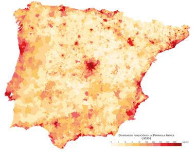
Population density by 2020

- Municipalities more populated
- Metropolitan areas
Political division
The Iberian Peninsula comprises a large part of Spain, Portugal, all of Andorra, a small part of France and all of Gibraltar. Historically, the Iberian Peninsula has been called the European continental territory that is located south of the Pyrenees.
| Country or unit | Population | Extension (km2) | % Extension | Capital |
|---|---|---|---|---|
| Spain | 46 468 102 | 493 515 | 84,663 % | Madrid |
| 10 374 822 | 88 944 | 15.258 % | Lisbon | |
| Andorra | 79 218 | 453 | 0.078 % | Andorra la Vieja |
| 12 035 | 539 | 0.1 % | Paris | |
| 32 194 | 6 | 0.001 % | Gibraltar | |
| Iberian Peninsula | 56 966 371 | 583 254 | ||
- ↑ It is not included in the Balearic Islands, the Canary Islands, Ceuta, Melilla, and the islands and islets in North Africa, not to be part of the Iberian peninsula.
- ↑ Azores and Madeira are not included because they are not part of the peninsula.
- ↑ Gibraltar has the status of overseas territory of the United Kingdom of Great Britain and Northern Ireland; therefore, unlike Spain, Portugal, France and Andorra is not a State.
Contenido relacionado
Cauca (Colombia)
1875
Earth sciences