Ibaraki Prefecture
The Ibaraki Prefecture (茨城県, Ibaraki-ken?) is one of the forty-seven prefectures that make up Japan and is located in the Kantō region of the island of Honshū; its capital is Mito.
. Ibaraki Prefecture was formerly known as Hitachi Province; In 1871, the name changed to Ibaraki Prefecture, at the beginning of the Meiji Era, and in 1875 it became its current size, by annexing some districts belonging to the extinct Shimōsa Province.
Geography
The northern part of the prefecture is mountainous, but most of the prefecture is a flat plain with several rivers, lakes, and lagoons. The flat part corresponds to 64% of the area (3,913 km²) of the territory, and the water of its territory corresponds to 4.8% (292.6 km²) of its surface.
Limits
It is bordered by the Pacific Ocean to the east, Chiba Prefecture to the south, Saitama Prefecture to the southwest, Tochigi Prefecture to the west, and Fukushima Prefecture to the north.
Natural parks of Ibaraki.
The prefecture has a quasi-national park called Suigō-Tsukuba Quasi-National Park (水郷筑波国定公園), with nine prefectural nature parks, namely Oku Kuji Prefectural Nature Park (奥久慈県立自然公園), Prefectural Nature Park Hanazono Hananuki (花園 花貫 県 立自然 公園), Takasuzu Prefectural Natural Park (高鈴 県 立自然 公園), ōta prefectural natural park (太田 太田 立自然 公園 公園 公園 公園 公園 公園 公園 公園 公園 公園 公園 公園 公園 公園 公園 公園 県 公園 太田 太田 県 太田 立自然 太田 立自然 県 立自然 立自然 立自然 立自然 公園)) 大洗 県 立自然 公園), Kasama Prefectural Natural Park (笠間 県 立自然 公園), Wagakuni Atago Prefectural Park (吾国 愛宕 立自然 立自然 公園) and prefectural natural park myth (水戸 水戸 県 立自然 公園), and also has a geological natural park, Ibaraki Prefecture North Geopark (茨城県北ジオパーク).
Suigō-Tsukuba Quasi-National Park. It is a park that covers an area in the southeast of Ibaraki Prefecture and another area in the northeast of Chiba Prefecture, contiguous. The park was established on March 3, 1953, to protect the natural areas and cultural heritage of Kasumigaura Lake in Ibaraki Prefecture, the Tone River Basin on the border of Ibaraki and Chiba Prefectures, and the areas around the Cape Inubō, Byōbugaura Inlet, and Cape Gyōbumi in Chiba Prefecture. On February 1, 1969, the areas surrounding Mount Tsukuba and Mount Kaba in Ibaraki Prefecture, not adjacent to other park areas, have been added to the Suigō-Tsukuba Quasi-National Park.
Main Mountains
- Yamizo with a height of 1.022 m. n. m.
- Takasasa with a height of 922 m. n. m.
- Tsukuba with two summits: Nyotai-San of 877 m. n. m. and Nantai-San of 871 m. n. m.
- Osho with a height of 804 m. n. m.
- Hanazono with a height of 798 m. n. m.
- Kaba with a height of 709 m. n. m.
Rivers of Ibaraki
The main rivers of the prefecture are:
- Rio Tone, with a tour in Ibaraki of 133.96 km of a total of 292,3 km of the Pacific Ocean. The river originally flowed into Tokyo Bay, and tributaries like the Watarase and Kinu rivers had independent water systems. To control floods and promote navigation in the centuryXVII a series of great works began, at the time when the Kanto region became the political centre of Japan. The current course was partly determined during the Meiji era.
- Kinu River (怒️), with a 62.84 km Ibaraki tour of a total of 174,5 km, leads to the Tone River. Prior to the Edo period, the Keno River (Written Dialogue - Today Kino), was the main river of the Keno River system, which poured its waters along with the missing Hitachi River (Distributing川️) in a large missing inner lake, called Mar Katori (excluding katori-umi), which included the current lakes of the Kasumigaura and the Tega Lagoons (note)) and Inbafect Pacific Connection. This river, called Keno at the time, divided from north to south into the country or province of Keno, a former area of Japan, which included the current prefectures of Gunma and Tochigi. During the Edo period, work was done on the development of the Tone River Basin to avoid flooding and allow the transport of passengers and goods by river and the separation of the Kokai River and the Keno River (today Kinu) to connect them with the Tone River.
- Rio Naka (≤5), with a tour in Ibaraki of 46.5 km of a total of 165.2 km, leading to the Pacific Ocean.
- River Kuji (public川 event), with a 70.03km Ibaraki tour of 119.6 km, leading to the Pacific Ocean.
- Kokai River (assistance), with a tour in Ibaraki of 75.6 km of a total of 111.8 km, leads to the Tone River.
- Rio Sakura (川️), with its total tour of 63 km in Ibaraki, leads to Lake Kasumigaura.
- Shintone River, with its total tour of 33 km in Ibaraki, leads to Lake Kasumigaura. This river is a derivation of the Tone River to lower the water level of that Tone River, the works were performed in the centuryXVII. The Shintone is born east of the mouth of the Kokai River in the Tone River.
- Watarase River, with a final tour in Ibaraki of 6.3 km of a total of 106.7 km, there in the city of Koga, unload its waters in the Tone River. Although the river currently unloads on the Tone River, its original route was via the Edo River; its route was changed as part of the massive land recovery and flood control undertaken by the Tokugawa shogunate in the seventeenth and eighteenth centuries.
- River Edo (Forwards), with an initial journey in Ibaraki of 2.2 km of a total of 59.5 km, is born in the population of Goka to Tokyo Bay; its birth currently derives as an arm of the Tone River. In the past the course of the river Edo was different, it was corrected its channel of origin and diverted to the river Tone in the centuryXVII by the Tokugawa shogunate to protect the city of Edo (today Tokyo) from flooding.
Lakes and lagoons of Ibaraki
The main lakes and lagoons of Ibaraki are:
- Lake Nishi-ura with an extension of 167.63 km2.
- Lake Kita-ura with an extension of 35.16 km2.
- Lake Sotonasaka-ura (Link)) with an extension of 5,85 km2.
- Laguna Hi-numa ()) with an extension of 9.36 km2.
- Laguna Ushiku-numa ()) with an extension of 3,49 km2.
- Laguna Senba-ko (mainstream learning) with an extension of 0.33 km2.
The combination of lakes Nishiura, Kitaura and Sotonasakaura is known as Lake Kasumigaura (霞ヶ浦).
Cities
|
|
|
|
|
Districts and their municipalities
|
|
|
|
|
|
|
History
The region was known as the "Hitachi Land Topography," where the land is large, the soil is fertile, the products of the mountains and the sea are abundant, and people drive prosperous lives.
In the medieval period, powerful samurai had their residences in this area, particularly in the Edo Period, with Hitachi Province being an important transportation hub due to its proximity to Edo (now Tokyo). A part of the Tokugawa feudal clan, the Mito Clan, settles in the region and flourished there as the center of local politics, economy and culture.
After the shogunate was abolished at the start of the Meiji Era, Ibaraki Prefecture was established in 1871, and became its present size in 1875.
- Prehistory
- It is believed that humans began to live in the area of the current prefecture from before and after the deposition of the volcanic ash layer from Caldera Aira about 24,000 years ago. At the bottom of this layer are local polished stone tools and burnt pebbles.
- Jōmon period
- Mar Katori's disappearance begins.
- Period Heian
- Taira no Masakado served in the imperial court of Kyoto, then dedicated himself to the life of rural knight in the eastern provinces of Japan, northeast of the present city of Tokyo.
- Period Muromachi
- Kitabatake Chikafusa wrote the book “Chronicles of the Authentic Lineages of the Divine Emperors” in the area of the Province of Hitachi. This is a Japanese historical book.
- Period Tokugawa (1603-1868)
- Clan Mito (interested parties). One of the three houses or clans coming from Tokugawa Ieyasu (Gosanke , three houses)
- Mitogaku (Mito School) of the Edo period
- Myth Kaidō. A route (Kaidō) from the Edo period
- Incidente Sakuradamon (1860) (і)の)の))
- Rebellion of Myth or Rebellion of Tengutō (1864-1865)
- Imperial period (1868-1945)
- Jōban Coal Yacimiento
- Post-war period (1945-present)
- Tōkaimura and nuclear energy
- Tsukuba EXPO 1985
- 2011 Japan Earthquake and Tsunami
Economy
Ibaraki's economy is supported by the machinery, electrical, chemical, precision machining, research institutes, and tourism industries, among others. Another important sector is agricultural, fishing and livestock activities in the prefecture.
Agriculture
It is one of the prefectures with the highest agricultural production in the country; which has large flat land with plenty of water and a suitable climate; Under these privileged conditions, Ibaraki plays an important role in supplying food to the Tokyo metropolitan area. Its production of melons, pears, peppers, various varieties of rice and sugar cane among others stands out; also flowers, ornamental plants, and forestry.
Fishing
It is one of the prefectures with the highest fishing production in the country; In the Pacific Ocean, Lake Kasumigaura, other lagoons and rivers, various species of fish are obtained. Among others, anglerfish fishing stands out in the prefecture.
Hitachigyū Cattle
The Hitachigyū cattle (常陸牛 - ひたちぎゅう- Hitachi-gyū), which is a bovine breed from the prefecture, is noteworthy in livestock. The name comes from the kanji 常陸 (Hitachi), name of the former Hitachi Province, and 牛 (ushi or gyū, beef)..
Background. In the months of January-February 1833 Tokugawa Nariaki (徳川斉昭) established black cattle breeding in present-day Migawa-chō (見川町) in the city of Mito. Originally it was mainly kept in the northern part of the prefecture, but later spread throughout the prefecture.
Features. Hitachi beef (Hitachi-gyū or Hitachi-ushi) is Japanese black cattle raised by licensed producers in Ibaraki Prefecture, with a performance grade of A or B in the Japan Meat Grading Association trade standard (日本食肉格付協会 Japanese meat rating association), is a brand of beef that has been ranked above 4 in the range of 1 to 5 for meat quality. For feeding, barley, wheat, corn, soybeans, dry grasses, rice straw are used.
Trademark registration. The names of both Hitachi Gyū and Hitachi Ushi are registered in the designation of the trademark registration, with the registration number 2055050 of June 24, 1988 and the owner of the right is the National Federation of Agricultural Cooperative Associations (全国農業協同組合 連合会National Federation of Agricultural Cooperative Associations).
Main industrial hubs
• Hitachi Area. Grouping of industries such as electrical industry and machinery. There are about 1,300 companies; most of them were hired by the company Hitachi, Ltd., which was founded in Sukegawa (present-day Hitachi city) in 1910.
• Tokai area. Association of research organizations on atomic energy. J-PARC, Proton Accelerator Research Complex.
• Tsukuba area. 32 institutes for education and research. Manipulation of matter at the level of atoms (nanotechnology). Robotic security center for support in daily life. space center.
• Kashima area. Grouping of materials industries. Some 160 companies in industries such as steel and petrochemicals
Demographics
Ibaraki's population has been increasing slightly as the Tokyo metropolitan region expands into the prefecture.
| Classification by region and estimated population as at 1 May 2017 | ||
| West | Centre | East |
|---|---|---|
| Prefecture of Tochigi | North Prefecture 611.001 | Pacific Ocean |
| Prefecture Centre 464.897 | ||
| West Prefecture 547.854 | South of prefecture 1.001.173 | East Prefecture 272.719 |
| Total: 2,897,644 | ||
Culture
Ibaraki Prefecture has several cultural heritage sites, including Kairakuen Park and Kashima (Jingū) Shrine.
Notable Japanese artists were born in Ibaraki, including painter Taikan Yokoyama, creator of the Japanese Nihonga painting technique, artist Hazan Itaya, a pioneer of modern Japanese ceramics, and poet and lyricist of children's and folk songs Ujō Noguchi.
To maintain a traditional cultural background, the prefecture organizes a full program of cultural activities; these include the Tsukuba International Music Festival, famous exhibitions at the Ibaraki Museum of Modern Art in Mito, and art festivals in townships. In recent years, a trend towards enriching the mind or seeking a better quality of life has spread widely among the people of Ibaraki, with many locals engaging in cultural activities on a voluntary basis. In response to this trend, in 1991 the prefecture established guidelines for cultural promotion, and the following year the Ibaraki Cultural Foundation was created. The prefecture has been working on creating new local cultural attractions.
Another aspect is the advancement in science and technology, which has been developed in the prefecture, with the city of Tsukuba as a pilot center.
Tourism and places of interest
Lake Kasumigaura to the southeast and the Tone River to the south, from the prefecture.
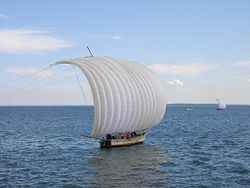
Sailboat Hobikibune (Hobikisen) floating on Lake Kasumigaura.
Fukuroda Falls in the town of Daigo.
Kairaku-en Park in the city of Mito.
Mito Botanical Garden in the city of Mito.
Ibaraki Prefectural Museum History in the city of Mito.
University of Tsukuba, JAXA, NIMS, KEK and other scientific research centers in the city of Tsukuba.
Mount Tsukuba in the city of Tsukuba.
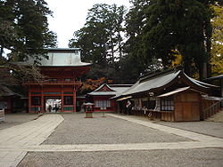
Tsukuba Shrine in the city of Tsukuba.
Tsukuba Circuit in the city of Shimotsuma.
Amida Buddha in the city of Ushiku.
Kashima Shrine in the city of Kashima.
Kashima Soccer Stadium in the city of Kashima.
Ibaraki Airport in the city of Omitama.
Ibaraki Nature Museum Park (Park Ibaraki Nature Museum) in the city of Bandō.
Maekawa Iris Garden (Maekawa Iris Garden) in the city of Itako.
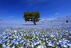
Ibaraki Prefecture Flower Park (Ibaraki Prefecture Flower Park) in the city of Ishioka.
Ryūjin kyō Canyon, Ryūjin Dam, and Ryūjin Great Suspension Bridge in the city of Hitachiōta.
Kashima Port in the cities of Kamisu and Kashima.
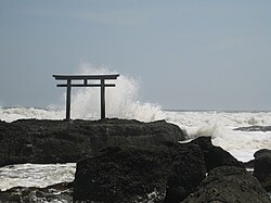
Aqua World (Ōarai Aquarium), Ōarai Sea Museum, Ōarai Marine Tower, Ōarai Isosaki Shrine, Ōarai Town Harbor and Bay.
Shinsui Park, Water Science Museum and the Rainbow Tower in Namegata City.
Tōkai Nuclear Power Plant in the town of Tōkai.
Mito Castle (水戸城) in the city of Mito.
Sakasai Castle (逆井城) in the city of Bandō.
Toyoda Castle (豊田城), known as the Jōsō Regional Exchange Center.
Tsuchiura Castle (土浦城) in the city of Tsuchiura.
Oldest rural house (国指定重要文化財平井家住宅 Inashiki-shi, Shibasaki (柴崎), 155) of the prefecture in the city of Inashiki.
JRA (Japan Racing Association) horse training center in the town of Miho.
Yūki-tsumugi, silk weaving technique, Intangible Cultural Heritage of Humanity, UNESCO; in the city of Yuki.
Hitachi's Fūryūmono, UNESCO Intangible Cultural Heritage of Humanity puppet float theater festival; in the city of Hitachi.
Kagami Crystal Glass Factory, an old glass factory in the city of Ryūgasaki.
Kasama pottery in the city of Kasama.
Hitachi coastal park located near the coast of the Pacific Ocean coastline.
Symbols of the prefecture
The symbols of Ibaraki. Ibaraki Citizen's Day is November 13, it is the day when history should be thought about, citizens increase their spirit of autonomy and wish to develop their homeland.
The Ibaraki flag and shield are inspired by the rose that dynamically symbolizes the opening of the button due to the deep relationship between nature and history. Ibaraki's anthem evokes that love of the law, freedom, and peace will reign forever in this place. The Ibaraki flower, goes according to the name of Ibaraki (bara = pink), symbolizes the heart of the population. The Ibaraki tree is the plum tree (ume), in the Kairaku-en garden there are about 100 species and 3000 feet of plum trees. Ibaraki's bird is the lark (hibari), proclaimed as the angel of spring that flies high in the sky, harmonizing with this prefecture.
Relevant people from the prefecture
• Tokugawa Mitsukuni, also known as Mito Kōmon, was a prominent Mito-born daimyō who ruled the Mito Domain.
• Tokugawa Yoshinobu, also known as Keiki, was a Japanese military man, son of Tokugawa Nariaki, daimyō of Mito. He was the fifteenth and last Tokugawa shōgun, and also the last shōgun of Japan.
Transportation
Railroads
- East Japan Railway Company
- Jōban Line
- Utsunomiya Line (Tōhoku Main Line)
- Line Mito
- Line Suigun
- Kashima Line
- Metropolitan Intercity Railway
- Tsukuba Express
- Kantō Railway
- Jōsō Line
- Ryūgasaki Line
- Kashima Rinkai Railway
- Line ⋅arai Kashima
- Kashima Rinkō Line
- Hitachinaka Kaihin Railway
- Line Minato
- Mooka Railway
- Mooka Line
Funicular and cable car
- Tsukuba Kankō Railway
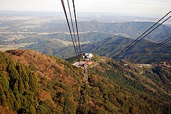
- Funicular Monte Tsukuba
- Teleférico Monte Tsukuba
Roads
Highways
- Jōban Expressway
- Kita-Kantō Expressway
- Higashi-Kantō Expressway
- Ken-ш Expressway or Metropolitan Inter-City Expressway, is a united motorway with the Aqualine Tokyo Bay and the Bayshore Route, to form a road ring, most of which is completed, to externally circumvent the Tokyo metropolis, within a radius of 40 to 60 kilometers, and its length is approximately 300 kilometers.
National Routes
Prefectural Routes
Ports
- Port of Ibaraki
- Port of Hitachi
- Port of Hitachinaka
- Port of ignoarai
- Port of Kashima
Airports
- Ibaraki Airport - Hyakuri Airfield
- Ryūgasaki airfield
Miscellaneous
The correct name of the prefecture is Ibaraki, written in Roman characters with the letter K. Some people and sources write the name as Ibaragi (pronounced ibaragui ) due to the soft pronunciation of the letter K in the local dialect.
- Murdoch's map of provinces 1903, Old Provinces of Japan
- Antique Map of the province of Hitachi in Japan
- List of historic sites of Ibaraki
Contenido relacionado
Estad Hidalgo
Taifa art
Carlos Martel

