
Howland island
Howland Island is one of the fourteen unincorporated territories of the United States of America. It has an area of 2.6 square kilometers and is located north of the Earth's equator, in the Pacific Ocean, halfway between the state of Hawaii and Australia in Oceania.
History
Historical Background
Although some scant road remains and other artifacts indicate an earlier Polynesian presence, the island was uninhabited when the United States claimed it under the Guano Islands Act of 1857. Its guano deposits were mined by US companies USA and Great Britain during the second half of the 19th century. A brief colonization attempt began in 1935, with a rotating population of four young Hawaiians at the Itascatown settlement. Similar projects were started on nearby Baker Island and Jarvis Island, but these were interrupted by World War II and the islands were abandoned.
Howland Island was one of the planned refueling stops for American pilot Amelia Earhart and her companion Fred Noonan on their 1937 round-the-world flight. They took off from Lae, New Guinea, but were never seen again. For this reason the island is also known as "the island that Amelia Earhart never reached".
U.S. civilian personnel evacuated the island in 1942 after Japanese air and naval attacks during World War II. Howland was occupied by US military personnel, but they abandoned it after the war. In order to enter the island, a special permit from the “U.S. Fish and Wildlife Service" which is generally awarded only to scientists and students.
The difficult life on these isolated islands coupled with the lack of reliable freshwater supplies may have led to the abandonment and extinction of the settlements, as did other islands in the area (such as Kiritimati and Pitcairn).
Sightings by Whalers
Captain George B. Worth of the Nantucket whaler Oeno sighted Howland around 1822 and named it Worth Island. Daniel MacKenzie of the American whaler Minerva Smith was unaware of the Worth sighting when he charted the island in 1828 and the after his ship's owners on December 1, 1828. Howland Island was finally named on September 9, 1842 what gave it its name was an observation that was being carried out on Isabella's whaler under the command of Captain Geo. E. Netcher of New Bedford.
US Possession and Guano Mining
Howland Island was uninhabited when the United States took possession of it under its Guano Islands Act of 1856. The island was a known hazard to navigation for many decades, and several ships were wrecked there. Its guano deposits were mined by American companies from about 1857 until October 1878, although it was not without controversy.
Captain Geo. E. Netcher of the Isabella informed Captain Taylor of his discovery. Since Taylor had discovered another guano island in the Indian Ocean, they agreed to share the benefits of the guano on the two islands. Taylor put Netcher in communication with Alfred G. Benson, president of the American Guano Company, which was incorporated in 1857. Others were approached by George and Matthew Howland, who later became members of the United States Guano Company, dedicated to Mr. Stetson visiting the island on the Rousseau ship under the command of Captain Pope. Mr. Stetson came to the Island in 1854 and described it as being occupied by birds and a plague of rats.
.jpg)
The American Guano Company established claims with respect to Baker Island and Jarvis Island, which was recognized under the Guano Islands Act of 1856. Benson was a treaty to interest the American Guano Company in the Howland Island deposits However, the directors of the company considered that they already had enough deposits. In October 1857, the American Arthur Benson son of Baker and Jarvis went to study the guano deposits. He also visited Howland Island and took samples of the guano. Later Alfred G. Benson resigned from the American Guano Company and together with Netcher, Taylor and George W. Benson formed the American Guano Company of the United States to exploit the guano of Howland Island, with this claim being recognized under the law of the American guano Islands of 1856.
However, when the American Guano Company took out a ship in 1859 for guano exploitation, they found that Howland Island was already occupied by men sent there by the American Guano Company. The ventures ended up in New York state courts, with the American Guano Company arguing that the American Guano Company had in effect abandoned the island, as the continued possession and actual occupancy required for the property by the company did not occur. Guano Islands Law. The end result was that both companies were allowed to exploit the guano deposits, which were substantially depleted by 1878.
In the 19th century there were British claims to the island, as well as attempts to create mining. The John T. Arundel Company, a British company with workers from the Cook Islands and Niue, occupied the island from 1886 to 1891. To clarify American sovereignty, Executive Order 7368 was issued on May 13, 1936.
Itascatown (1935-1942)
In 1935, a brief colonization attempt was made by Baker, Howland and Jarvis Islands; administered by the Department of Commerce to establish a permanent US presence over the islands. It all started with a group of four Kamehameha School for Boys students and alumni from a private school in Honolulu. Although the recruits were part of a scientific expedition in order to spend three months collecting biological and botanical samples. Once at sea they were told, "Your name will go down in history" and that the islands would become "famous air bases on a route that will connect from Australia to California."
His appointment was after the USCGC Itascatown (Itasca) brought settlers to Howland and after making voyages between the other islands around this time. Itascatown was a stocking line for dozens of small wooden boats, structures, and shops near the beach on the west side of the island. The fledgling settlers were "paid" with copious amounts of canned food, water, and other materials including a refrigerator with gasoline, radio equipment, medical equipment, and (characteristic/materials of the time) numerous cigarettes. Fishing was always essential to their diet. Most of the colonists toiled by the hour, making weather observations and progressively developing a rudimentary infrastructure on the island, including the construction of a landing strip for airplanes. During this period, the island was on Hawaiian time, which is 10.5 hours behind UTC. Similar colonization projects began near Baker Island, Jarvis Island, and two other islands.
Kamakaiwi Field
The land was treated to make a runway for airplanes in the mid-1930s, as the island could eventually become a stopover site for trans-Pacific air routes and also for other land claims in the region against rival claims from Great Britain. Howland Island was designated as the refueling post for American pilots such as Amelia Earhart and navigator Fred Noonan on their 1937 circumnavigation of the world. Public funds were used by the Bureau of Commerce to build three unpaved runways; tracks only to accommodate machinery such as the twin-engine Lockheed Electra Model 10 Earhart. The service is called Kamakaiwi "Field of James," after a young Hawaiian who arrived with the first group of four settlers. He was selected as the group's leader and spent more than three years in Howland, much longer than the average of the other recruits. It has also been referred to as WPA Howland Airport (the WPA made up about 20 percent of the $12,000 it cost).
World War II
A Japanese air raid on December 8, 1941, carried out by 14 twin-engined Mitsubishi G3M "Nell" by Chitose Kokutai bombers from the Kwajalein Islands, killed two of the Kamehameha School settlers: Richard "Dicky" Kanani Whaley and Jose Kealoha Keli'hananui. The attack happened a day after the attack on Pearl Harbor and damaged the three airstrips in the Kamakaiwi field. Two days later, a Japanese submarine turned what little remained of the colony's buildings into ruins. A single bomber returned twice over the next several weeks, dropping bombs on the rubble of Itascatown. The two survivors were finally evacuated by the USS Helm, a Navy destroyer, on January 31, 1942. Howland was occupied by a battalion of the United States Marine Corps in September 1943 and was known as Station Howland Naval Air Force until May 1944.
All settlements were abandoned after 1944. Colonization projects on the other four islands were also interrupted by the war and ended at that time. No aircraft are known to have landed there, although nearby anchorages could be used by seaplanes and flying boats during World War II. For example, on July 10, 1944, a Navy Martin PBM-3-D Mariner flying boat (BuNo, 48199), piloted by William Hines, had an engine fire and made a forced landing offshore in the Howland Ocean.. Hines grounded the plane and although it burned, the crew escaped unharmed and were rescued by the USCGC Balsam (the same ship that later took Unit 92 to Gardner Island), transferred to a submarine chaser and taken to Canton Island..
Geography
.jpg)
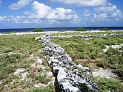
Located in the North Pacific Ocean, the island is very small (1.6 km²). The coastline is 6.4 km long. The island is elongated in shape on a north-south axis. The climate is equatorial, with little rainfall, constant wind and hot sun. The terrain is low and sandy: a coral island surrounded by a stretch of reef with a depressed surface in the center. The highest point is 3 meters above sea level. The island lacks potable water. The only natural resource is guano.
Geographically, along with Baker Island, it is part of the Phoenix Islands. For statistical purposes, Howland Island is grouped as one of the United States Minor Islands.
Howland Island covers an area of 1.6 km², with 6.4 km of coastline. The Island has an elongated banana shape on a north-south axis. There is no lagoon.
The island is now a Howland Island National Wildlife Refuge, managed by the U.S. Fish and Wildlife Service as a US Department of the Interior Island Area. The Howland Island National Wildlife Refuge consists of the 1.6 km² of the island and the 129.80 km² of submerged land surrounding it.
The island has no economic activity. It is better known as "Amelia Earhart" pilot of which her plane disappeared on July 2, 1937, during its planned trip around the world. The runways built for its provisional stop were eventually damaged, unmaintained, and gradually disappeared. There are no docks or ports. The reef may represent a maritime hazard. There is an area where boats can be parked along half the beach on the west coast, as well as a day lighthouse. The Island is visited every 2 years by the United States Fish and Wildlife Service. Its defense is the responsibility of the United States and it is visited annually by units of the United States Coast Guard.
Flora and fauna
The climate is equatorial with little drizzle and intense sun. The temperatures are moderate due to a constant wind coming from the east. The terrain is low altitude and sandy; a coral island surrounded by a reef with a central area. The highest point is around 6 meters above sea level.
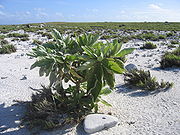
There is no natural fresh water. The landscape is characterized by diverse grasslands along with shrubs and huge trees. An eyewitness description from 1942 tells of “a grove full of death and decay” on a shallow slope in the center of the island. In 2000, a visitor accompanying a scientific expedition reported seeing “a plain full of coral with sand, without a single tree” and some traces of ruins. Howland is primarily a habitat for seabirds, shorebirds and marine life.
The United States declared a 200 nautical mile (370 km) Exclusive Economic Zone and a 12 nautical mile (22 km) territorial sea around the island.
Since Howland Island is uninhabited, there is no specified time zone. You encounter a nautical time that is identified as 12 hours behind UTC.
Wildlife refuge
On June 27, 1974, Secretary of the Interior Rogers Morton created the Howland Island National Wildlife Refuge, which was expanded in 2009 to add submerged land within 12 miles nautical (22 km) of the island. The refuge now includes 648 acres (2'62 km²) of land and 410,351 acres (1,660'63 km²) of water. Along with six other islands, the island was managed by the US Fish and Wildlife Service as part of the Pacific Remote Islands National Wildlife Refuge Complex. In January 2009, that entity was changed to the Pacific Remote Islands Marine National Monument by President George W. Bush. The island's habitat has suffered from the presence of multiple alien invasive species. Black rats were introduced in 1854 and eradicated in 1938 by feral cats, introduced the year before. The cats proved destructive to bird species and were eliminated in 1985. Pacific weeds continue to compete with local plants.
Public entry to the island is only by permission of the US Fish and Wildlife Service is generally limited to scientists and educators. Agency representatives visit the island, on average, once every two years, constantly coordinating transportation with amateur radio operators or the US Coast Guard to cover the high costs of logistical support.
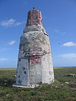
Earhart Lighthouse
Settlers, sent to the island to claim territory for the United States, built the Earhart Lighthouse (0 ° 48'20.48 "N 176 ° 37'8.55" W), named thus in honor of Amelia Earhart as a blind beacon or navigation reference point. It is similar in shape to a short lighthouse, and was built of white sandstone with black painted stripes and a top of the same color to be visible several kilometers out to sea during the day. It is located near the pier in the center of the west coast of the former headquarters of Itascatown.
The lighthouse was partially destroyed during World War II by Japanese raids, but was rebuilt in the early 1960s by US Coast Guard “Blackhawk” men.
In 2000, the lighthouse was slated for demolition, having not been painted in decades.
Ann Dearing Holtgren Pellegreno flew over the island in 1967, and Linda Finch did so in 1997 during the circumnavigation memorial flights to commemorate Earhart's 1937 world flight. Neither attempted to land, but they flew low enough to leave a wreath on the island.
Image Gallery
Earhart Lighthouse with postwar repairs

Remains of a plane in Howland
Remains of the Itascatown settlement

Flora
Flora

Alcatraces pardos

Alcatraces pardos

Common returns


Transportation
The island lacks ports as the reefs can be dangerous. There is a landing stage on the west coast. There is also an airstrip, but it is no longer used. The airstrip was built in 1937 but suffered continuous damage during World War II and has been left in disuse and in a deplorable state.
Contenido relacionado
Politics of Afghanistan
Church of rome
Anne Boleyn