
History of the territorial organization of Spain
The history of the territorial organization of Spain, in the modern sense, is a process that began in the century XVI with the dynastic union of the Crown of Aragon and the Crown of Castile, the conquest of the Kingdom of Granada and later the Kingdom of Navarra. However, it is relevant to clarify the origin of the place name Spain, as well as what were the territorial divisions that previously existed in the current Spanish territory.
Definition of Spain
The name of Spain derives from Hispania, the name with which the Romans geographically designated the entire Iberian Peninsula, an alternative term to the name Iberia, preferred by the authors. Greeks to refer to the same space. This name was preserved after the fall of the Roman Empire as a designation for the peninsula under the Goths and among the Greco-Latin Christian world. After the Arab conquest, the part of the peninsula controlled by them was called, for centuries, Al Ándalus or alternatively Spania, although the Reconquista process ended up eliminating these names.
The unification of the various kingdoms of that geographical region led to a correspondence between that region and a single state during the brief period of union of Spain and Portugal, which ended in 1640. Since then Spain is explicitly used to refer to the current country of that name while Iberia is preferred to encompass it and Portugal.
In this article we will talk about the territorial organization of Spain throughout history, although the organization of other peninsular or bordering areas will be included when imposing current borders is anachronistic.
Pre-Roman stage
The Iberian Peninsula was originally occupied by peoples of different origins (Indo-Europeans, Iberians or of unknown ethnic origin such as Cantabrians, Várdulos and Vascones). These towns did not make any administrative division, organizing themselves as cities or tribes independent of each other.
Later, some historians have tried to create families of tribes that share the same cultural characteristics, particularly distinguishing between Iberians from the Levant and the south of the peninsula, Celts on the plateau and Vascones and Cantabrians in the north. The limits between some areas and others are reasons for discussion, without agreement on whether or not to include peoples such as the Lusitanians among the Celts or as peoples per se. These classifications do not imply that there was a common administrative organization between said tribes.
| Pre-Roma peoples and their linguistic affiliation before the conquest | |
|---|---|
 | C1: Galaicos / C2b: Tracaros C3: Cantabris / C4: Astures / C5: Vacceos / C6: Turmogos / C7: Autrigones-Caristios / C8: Várdulos / C9: Berones C10: Pelendones / C11: Belos / C12: Lusons / C13: Titos / C14: Olcades / C15: Sharks C16: Carpetanos / C17: Vetons / C18-C19: Celtics / C20: Conios / L1: Lusitanos |
| A1: Aquitaine / A2: Vascones I1: Ceretanos / I2: Ilergetes / I3: Lacetanos / I4: Indigetes / I5: Layetanos / I6: Ilercavones / I7: Sedetanos / I8: Edetanos / I9: Contestanos / I10: Oretanos / I11: Bastetanos / I12: Turdetanos | |
| G1: Greek / P1: Fenicios/Cartagines / B1: Berbers | |
Roman division

The Romans carried out various divisions of the peninsula throughout the history of their Empire:
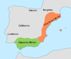
- Division 197 a. C. (their limits were not accurate, as only the coastline was dominated):
- Hispania Citerior: Ebro Valley and Mediterranean coastline.
- Hispania Ulterior: Valle del Guadalquivir.
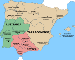
- Division in the Upper Roman Empire in three provinces divided into legal convents:
- Hispania Bética
- Hispania Ulterior Lusitania
- Hispania Citerior Tarraconensis
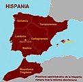
- Diocese Hispaniarum (III century) divided into six (after seven) provinces (one in North Africa):
- Tarracon
- Carthaginense
- Baetica
- Lusitania
- Gallaecia
- Balearic: this division appeared in the middle of the centuryIVunder the reign of substance I and Constantine II
- Mauretania Tingitana.
First division of Hispania in two provinces: Citerior and Ulterior
Division performed during Roman domination conventusancestor of the current judicial parties
Provincial Division of Diocletian in 298


Barbarian and Muslim kingdoms

With the fall of the Roman Empire, the Suebi, Visigoths and other peoples occupied most of the peninsula. Finally, the Visigoths gained control of the entire peninsula in the VI century after conquering the Swabian kingdom. They maintained the Roman provincial administrative division (under the name "duchies") and even created new duchies, such as Asturias and Cantabria, and the province of Celtiberia and Carpetania.
Starting in 711, the Muslims conquered the peninsula and continued to control part of it until 1492, the year in which the Taking of Granada took place. The Muslim kingdom was divided into coras or kuras, all of which depended on some city. Later, as Muslim power declined, the coras became independent, creating small states with their own king, the so-called kingdoms of taifas.
Reconquista
With the Reconquista, several kingdoms were created: the Kingdom of Asturias (718), which claimed Visigothic legitimacy and was renamed the Kingdom of León in 925, from which the Kingdom of Castile became independent in 1065 and the Kingdom of Portugal. in 1139. The Kingdom of Galicia was also created in the year 910, intermittently independent from the Kingdom of León although subordinate to it (910-914, 926-929, 981-984, 1065-1073).
With the Catholic Monarchs, each of these kingdoms maintained their own administrative divisions: in Castile, the provinces, and in the Crown of Aragon: districts in Aragon, veguerías in Catalonia and Mallorca, and in Valencia there were four governorates and eleven districts.
16th century
Crown of Castile

The territory of the kingdom of Castile was distributed among the 18 cities with the right to vote in Cortes and in turn subdivided into parties, which in the census of 1591-1594 were not called that way, in some cases also receiving the name of province.
These constituencies created at the end of the XVI century, which are sometimes called provinces they lacked any legal or administrative value and were merely fiscal in nature, so one should avoid confusing this concept of province with the current one, and they did not constitute an administrative division at all. The only true administrative division existing at that time was the town and the municipality. Likewise, there were also other structures, such as townships, dioceses or lordships:
- Burgoswith Trasmiera, capital: Laredo and Tierras del Condestable, capital: Villalpando.
- Soria.
- Valladolidwith the Count of Benavente, capital: Benavente.
- León, with Principality of Asturias of Oviedo, capital: Oviedo and Ponferrada.
- Zamorawith the Obispado de Lugo, La Coruña and Betanzos, Orense, Mondoñedo, Santiago de Compostela and Tuy.
- Torowith the Party of Carrion and the Kingdom Party.
- Salamanca, with Trujillo and the Province of León of the Order of Santiago, capital: Llerena.
- Avila.
- Segovia.
- Guadalajara.
- Madrid.
- The Kingdom of Toledo, with Campo de Calatrava, capital: Almagro; Mesa Arzobispal de Toledo, capital: Talavera, Castilla de la Orden de Santiago, capital: Ocaña; Alfoz de Alcaraz, capital: Alcaraz; Castilla del Campo de Montiel, capital: Infantes and Ciudad Real.
- CuencaWith Huete.
- Kingdom of Murcia;
- Kingdom of Seville;
- Kingdom of Córdoba;
- Kingdom of Jaen, with Calatrava del Andalucía, capital: Martos;
- Kingdom of Granada.

Territorial division of the Iberian peninsula during the Old Regime.

Crown of Aragon
- Kingdom of Aragon;
- Kingdom of Valencia, with two governorates with capitals in Valencia and Orihuela, and two sub-governations with capitals in Castellón and Játiva.
- Kingdom of Mallorca.
- Principality of Catalonia, with twelve veguerias with capitals in Tortosa, Tarragona, Montblanch, Barcelona, Vich, Manresa, Villafranca del Panadés, Gerona, Camprodón, Lérida, Tárrega and Cervera.
Kingdom of Navarra
Intendencies of 1720


Felipe V created, based on the pre -existing provinces created by the Austrias, the institution of intentions. While it is true that these did not always coincide with the limits of the provinces, so there was some opposition to this division. required quote ]
Twenty were the intentions then created: those of La Coruña, León, Valladolid, Burgos, Pamplona, Zaragoza, Barcelona, Salamanca, Ávila, Guadalajara, Toledo, Madrid, Ciudad Real, Valencia, Mérida, Sevilla, Córdoba, Granada, Palma and Santa Cruz de Tenerife.
Fernando VI reorder the limits of the intentions, making them coincide with the provinces of the Austrias and the former kingdoms of Spain.
Tomás González Hernández, Master of the Cathedral Church of Plasencia, reorganizes the Royal Archive of Simancas, after the plunder suffered after the Napoleonic invasion. His work Population Census of the provinces and parties of the Crown of Castile in the 16th century has constituted the only source edited to know the Spanish population at the time of the Austrias. The archivist completes the known as Book of the millions with data from other regions: Catalonia, Vascongadas, Navarra, Valencia and Aragon.
Under the reign of Carlos III, on March 22, 1785, the Count of Floridablanca promoted the realization of a prompt or nomenclator of the peoples of Spain and maps were prepared to facilitate the control of the control of the kingdom:
At the end of the Old Regime the local jurisdictions offered a picture even more obsolete and anachronistic than that of the old provinces; distributed in royal jurisdictions, abadengas and secular dominion were the result of historical circumstances accumulated during the centuries and represented the antithesis of rationality and administrative efficiency.
The 19th century
During the 19th century, Spain witnessed a struggle between the Old Regime and the liberal State, with two antagonistic concepts of government. The liberal State needs a new territorial organization, which allows it to govern the country uniformly, collect taxes and create a single market with equal laws for all.
Soler Plan of 1799
At the beginning of the 19th century, a new division of the territory of Spain was carried out based on the Enlightenment criticism of the previous division. This division is part of a territorial reorganization project promoted by Miguel Cayetano Soler, general superintendent of the treasury, mainly with the intention of simplifying the tax system and rationalizing the collection of taxes, so that the new reform gave greater prominence to the mayor's delegates—the subdelegates of income—and the party meetings.
One of the most important points of it was the creation, by Royal Decree of September 25, 1799 and Instruction of October 4 of the same year, of six maritime provinces, Oviedo, Santander, Alicante, Cartagena, Málaga and Cádiz, respectively, separated from the Municipalities of León, Burgos, Valencia, Murcia, Granada and Seville, all of them very extensive provinces. All the provinces created in 1799 have continued to exist in the subsequent divisions, until the present day, with the exception of the period under the division into prefectures of 1810, and the province of Cartagena, which disappeared with the last and definitive provincial division of 1833, which currently remains in force except for slight modifications.
Prefectures of 1810
The outbreak of the War of Independence, in May 1808, established a new order at the hands of Napoleon, who placed his brother Joseph Bonaparte on the throne. In 1810, the Josephine government tried to organize the territory, dividing it into 38 prefectures, in the style of those established in France, and 111 sub-prefectures, according to the project of the engineer and mathematician José María Lanz. The prefectures would receive names related to geographical features, mainly rivers and capes. This division wiped out the historical conditions, but it never came into force.

38 peninsular prefectures plus the Balearic and Canary Islands were created:
- Aguedawith capital in Ciudad Rodrigo (equivalent to great features with the south of the current province of Salamanca and north of the province of Cáceres)
- Subprefectures in Ciudad Rodrigo, Béjar and Navarredonda
- Arlanzón, with capital in Burgos (equivalent to the center of the province of Burgos and La Rioja)
- Subprefectures in Burgos, Calahorra and Logroño
- Balearic Islands, with capital in Mallorca, without subprefectures
- Bidasoa, with capital in Pamplona (equivalent to Navarra)
- Subprefectures in Pamplona, San Sebastian and Olite
- Cabo de la Nao, with capital in Alicante (equivalent to Alicante, south of Valencia and east of Albacete)
- Subprefectures in Alicante, Denia and Játiva
- Cabo de Peñaswith capital in Oviedo (equivalent to Asturias, except the lands between the rivers Eo and Navia)
- Subprefectures in Oviedo, Gijón and Navia
- Corporal Machichacowith capital in Vitoria (equivalent to the Basque Country)
- Subprefectures in Vitoria, Bilbao and Azcoitia
- Cape Verde, with capital in Santander (equivalent to Cantabria)
- Subprefectures in Santander, Laredo and Villarcayo
- Canary Islands, with capital in Santa Cruz de Tenerife, without subprefectures
- Carriónwith capital in Palencia (equivalent to Palencia)
- Subprefectures in Palencia, Carrión de los Condes y Cervera de Pisuerga
- Cinca and Segrewith capital in Lérida (equivalent northwest of the province of Lérida)
- Subprefectures in Lérida, Seo de Urgel and Talarn
- Duero Altowith capital in Soria (equivalent to Soria)
- Subprefectures in Soria, El Burgo de Osma and Medinaceli
- Duero and Pisuergawith capital in Valladolid (equivalent to Valladolid, south of Burgos, Segovia and east of Ávila)
- Subprefectures in Valladolid, Aranda de Duero and Segovia
- Ebro, with capital in Tarragona (equivalent to the province of Tarragona, southeast of Lérida, east of Zaragoza, northeast of Teruel and north of Castellón)
- Subprefectures in Tarragona, Tortosa and Alcañiz
- Ebro and Cinca, with capital in Huesca (equivalent to the province of Huesca)
- Subprefectures in Huesca, Barbastro and Jaca
- Ebro and Jalon, with capital in Zaragoza (province of Zaragoza and north of the Teruel)
- Subprefectures in Zaragoza, Calatayud and Híjar
- That's it.with capital in Astorga
- Subprefectures in Astorga, León and Benavente
- Genilwith capital in Granada (Almeria and Granada Provinces)
- Subprefectures in Granada, Almería and Baza
- Guadalaviar Altowith capital in Teruel (south of the province of Teruel)
- Subprefectures in Teruel and Aliaga
- Guadalaviar Bajo, with capital in Valencia (province of Valencia and south of the Castellón)
- Subprefectures in Valencia, Castellón de la Plana and Segorbe
- Guadalete, with capital in Jerez de la Frontera (Province of Cadiz)
- Subprefectures in Jerez de la Frontera, Cadiz and Ronda
- Guadalquivir Altowith capital in Jaén (Japanese province)
- Subprefectures in Jaén, Úbeda and La Carolina
- Guadalquivir Bajowith capital in Seville (provinces of Huelva and Seville)
- Subprefectures in Seville, Ayamonte and Aracena
- Guadalquivir and Guadajoz, with capital in Córdoba (Province of Cordoba)
- Subprefectures in Córdoba, Écija and Lucena
- Guadiana and Guadajira, with capital in Merida (province of Badajoz and west of the Ciudad Real)
- Subprefectures in Merida, Badajoz and Llerena
- Jucar Alto, with capital in Cuenca (Province of Cuenca)
- Subprefectures in Cuenca and Tarazona de la Mancha
- Llobregat, with capital in Barcelona (province of Barcelona)
- Subprefectures in Barcelona, Manresa and Solsona
- Manzanares, with capital in Madrid (city of Madrid and surrounding areas)
- Subprefectures in Madrid and Alcalá de Henares
- Lowwith capital in Vigo (Province of Pontevedra)
- Subprefectures in Vigo, Pontevedra and Tuy
- Miño Altowith capital in Lugo (north of Lugo province and Asturian lands west of Navia)
- Subprefectures in Lugo, Mondoñedo and Vivero
- Eyes of Guadiana, with capital in Ciudad Real (province of Ciudad Real, south of Toledo and west of Albacete)
- Subprefectures in Ciudad Real and Alcaraz
- Roomwith capital in Malaga (province of Malaga and southeast of Seville)
- Subprefectures in Málaga, Osuna and Antequera
- Sure., with capital in Murcia (province of Murcia, northeast of the Granada, central part of the Albacete and the Baja del Segura vega of the province of Alicante)
- Subprefectures in Murcia, Cartagena, Albacete and Huéscar
- Silwith capital in Orense (province of Orense and southern Lugo Province)
- Subprefectures in Orense, Monforte de Lemos and Monterrey
- Tajo Alto, with capital in Guadalajara (Guadalajara province and northwest of Cuenca)
- Subprefectures in Guadalajara, Sigüenza and Huete
- Tajo and Alagónwith capital in Cáceres (province of Cáceres without its northern third)
- Subprefectures in Caceres, Plasencia and Talavera de la Reina
- Tajo and Alberche, with capital in Toledo (north of the province of Toledo, from the Tajo, and province of Madrid, without the prefecture of Manzanares)
- Subprefectures in Toledo, Ocaña and Casarrubios del Monte
- Tambrewith capital in La Coruña (La Coruña province)
- Subprefectures in La Coruña, Santiago de Compostela and Corcubión
- Ter, with capital in Gerona (Gerona Province)
- Subprefectures in Gerona, Vich and Camprodón
- Tormes, with capital in Salamanca (province of Zamora and north of Salamanca)
- Subprefectures in Salamanca, Toro and Zamora
Although the War of Independence prevented the adoption of all these reforms, in 1812 a decree allowed Catalonia to be annexed to France until 1814 as a new region divided into four departments:
- Department of the Ebro Ships with prefecture in Lérida and subprefectures in Cervera, Tortosa and Tarragona.
- Department of Montserrat with prefecture in Barcelona and subprefectures in Manresa and Villafranca del Panadés
- Segre Department with Prefecture in Puigcerda and Subprefectures in Solsona and Talarn
- Department of the Ter with prefecture in Gerona and subprefectures in Vich and Figueras
First attempt at provinces
The Cortes of Cádiz
In 1811 the Cortes of Cádiz repealed the jurisdictional lordships, thus disappearing the division between lordship and kingship, which despite the restoration of absolutism by Ferdinand VII in 1814 would not come into force again.
At the same time, the Courts of Cadiz try to create a new regime, also liberal, in which all provinces have the same obligations. The constitution of 1812 does not recognize the political personality of the ancient historical territories. This was approved by deputies from all provinces, including the American territories. The Courts reach a new system that does take into account historical conditioning. 32 provinces are created, according to the nomenclator of Floridablanca, with some corrections. In 1813, however, Felipe Bauzá was commissioned by a new provincial division, which determines 36 provinces, with seven subaltern provinces, with historical criteria. But none of this was approved, and Fernando VII's return meant the return to the Old Regime, with certain modifications. In 1817 Spain was divided into 29 mayors and 13 consulates.
Territorial division of 1822

After the uprising of General Riego, during the Liberal Triennium (1820-1823), the construction of the liberal state is promoted, and with it a new provincial division is promoted, although the representatives of 1813 first recover. It was that this division would reach the entire country, without exception, and would be the single scheme for administrative, governmental, judicial and economic activities, according to criteria of legal equality, unity and effectiveness. The project is entrusted to the technicians Felipe Bauzá and José Agustín de Larramendi.

In January 1822, the Cortes approved, provisionally, a provincial division of Spain in 52 provinces:
- province of Alicante, with capital in Alicante
- province of Almeria, with capital in Almeria
- province of Ávila, with capital in Ávila
- province of Badajoz, with capital in Badajoz
- province of Baleares (islas), with capital in Palma
- province of Barcelona, with capital in Barcelona
- province of Bilbao, with capital in Bilbao
- Burgos province, with capital in Burgos
- province of Cáceres, with capital in Cáceres
- province of Cadiz, with capital in Cadiz
- Calatayud province, with capital in Calatayud
- province of Canarias, with capital in Santa Cruz de Tenerife
- province of Castellón, with capital in Castellón de la Plana
- province of Ciudad Real, with capital in Ciudad Real
- Chinchilla province, with capital in Chinchilla
- province of Córdoba, with capital in Córdoba
- province of La Coruña, with capital in La Coruña
- province of Cuenca, with capital in Cuenca
- province of Gerona, with capital in Gerona
- province of Granada, with capital in Granada
- province of Guadalajara, with capital in Guadalajara
- province of Huelva, with capital in Huelva
- province of Huesca, with capital in Huesca
- province of Jaén with capital in Jaén
- province of Játiva, with capital in Játiva
- province of León, with capital in León
- province of Lérida, with capital in Lérida
- province of Logroño, with capital in Logroño
- province of Lugo, with capital in Lugo
- province of Madrid, with capital in Madrid
- province of Malaga, with capital in Malaga
- province of Murcia, with capital in Murcia
- province of Orense, with capital in Orense
- Oviedo province, with capital in Oviedo
- province of Palencia, with capital in Palencia
- province of Pamplona, with capital in Pamplona
- province of Salamanca, with capital in Salamanca
- province of San Sebastian, with capital in San Sebastian
- province of Santander, with capital in Santander
- province of Segovia, with capital in Segovia
- province of Seville, with capital in Seville
- province of Soria, with capital in Soria
- province of Tarragona, with capital in Tarragona
- province of Teruel, with capital in Teruel
- province of Toledo, with capital in Toledo
- province of Valencia, with capital in Valencia
- province of Valladolid, with capital in Valladolid
- province of Vigo, with capital in Vigo
- province of Vierzo, with capital in Villafranca del Bierzo
- province of Vitoria, with capital in Vitoria
- province of Zamora, with capital in Zamora
- province of Zaragoza, with capital in Zaragoza
Some of these provinces appear for the first time, such as those of Almería and Málaga (separated from the traditional Kingdom of Granada), Huelva (from the Kingdom of Seville), Calatayud and others appear with a new name, such as the Basque Provinces.
This project makes few concessions to history, and is governed by criteria of population, extension and geographical coherence. There is a desire to overcome historical names, preferring those of capital cities. Nor are the traditional boundaries of the provinces respected, creating a new map. The enclaves of some provinces are eliminated from others, if they belong to different kingdoms, but many enclaves are preserved when they are within the same one.
In 1822, provincial mayors were re-established as Treasury Delegates. But the fall of the liberal government and the restoration of absolutism brought the project to a close. In 1823 the provinces of the Old Regime were re-established so the plan of 1822 never came into force.
Territorial reform of 1833

This reform carried out by Javier de Burgos in 1833 basically adopted the 1822 project, and has been maintained with some changes - partition of the Canary Islands, inclusion of Castilian regions to Valencian provinces - until today. It divided the Spanish territory into 49 provinces based on a rational criterion, with a relatively homogeneous size and eliminating most of the exclaves and enclaves typical of the Old Regime. At the same time, it grouped the provinces into regions with a merely classificatory nature, without reserving for these any type of competence or administrative or jurisdictional body common to the provinces they grouped. The territorial organization was as follows:
- Andalusia: Almería, Cádiz, Córdoba, Granada, Huelva, Jaén, Malaga and Seville.
- Aragon: Huesca, Teruel and Zaragoza.
- Asturias: Oviedo.
- Balearic Islands: Balearic Islands
- Canary Islands: Santa Cruz de Tenerife
- Castilla la Nueva: Ciudad Real, Cuenca, Guadalajara, Madrid and Toledo.
- Castilla la Vieja: Ávila, Burgos, Logroño, Palencia, Santander, Segovia, Soria and Valladolid.
- Catalonia: Barcelona, Gerona, Lérida and Tarragona.
- Extremadura: Badajoz and Cáceres.
- Galicia: La Coruña, Lugo, Orense and Pontevedra.
- León: Leon, Salamanca and Zamora.
- Murcia: Albacete and Murcia.
- Navarra: Navarre.
- Valencia: Alicante, Castellón de la Plana, and Valencia.
- Basque: Álava, Guipúzcoa and Vizcaya.
This provincial division was only implemented for the peninsular area and adjacent islands, excluding the territories of Cuba, Puerto Rico, the Philippines, Mariana Islands, Carolinas, Palaos, Equatorial Guinea and the North African sovereignty squares (the Western Sahara, Ifni and northern Morocco had not yet been incorporated).
It stands out as the main difference that the Canary Islands had not been divided into two provinces to date, being Santa Cruz de Tenerife its capital. In 1927, with the appearance of the province of Las Palmas, the number of provinces increased to 50. Another difference is that the majority of the statutes of autonomy take the basis of this division, except those that have to do with the region of León, that of Castilla la Vieja the one of Castilla la Nueva and that of Murcia.
Regionalization of the nineteenth century
1847


In an attempt to regionalize the peninsula, Patricio de la Escosura promulgated a decree on September 29, 1847 - which was suspended the same year - dividing the peninsula into eleven general governments:
- Andalusia capital Seville. Provinces of Seville, Córdoba, Cadiz and Huelva.
- Aragon capital Zaragoza. Provinces of Zaragoza, Huesca and Teruel.
- Burgos capital Burgos. Provinces of Burgos, Santander, Logroño and Soria.
- Cantabria capital Pamplona. Provinces of Navarre, Álava, Guipúzcoa and Vizcaya.
- Castilla la Nueva capital Madrid and formed by the provinces of Madrid, Cuenca, Segovia, Guadalajara, Toledo and Ciudad Real.
- Castilla la Vieja capital Valladolid. Provinces of Valladolid, León, Palencia, Salamanca, Zamora, Ávila and Oviedo.
- Catalonia capital Barcelona. Provinces Barcelona, Lérida, Gerona and Tarragona.
- Extremadura capital Badajoz. Provinces of Badajoz and Cáceres.
- Galicia capital La Coruña. Provinces of La Coruña, Pontevedra, Lugo and Orense.
- Grenada the capital of Granada. Provinces of Granada, Malaga, Almería and Jaén.
- Valencia and Murcia Valencia. Provinces of Valencia, Murcia, Alicante, Albacete and Castellón.
1873

In 1873, during the First Spanish Republic, a draft Constitution was prepared that defined Spain as a Federal Republic, made up of seventeen States with legislative, executive and judicial power. According to articles 92 and 93, these "States" would have "complete economic-administrative autonomy and all political autonomy compatible with the existence of the Nation", as well as "the power to give themselves a political Constitution." This constitution, whose text is mainly attributed to Castelar, was never adopted. Being a federal Constitution, it says nothing about the provinces, a matter within the jurisdiction of the Member States. The first article of said project says:
Componen la Nación Española los Estados de Andalucía Alta, Andalucía Baja, Aragón, Asturias, Baleares, Canarias, Castilla la Nueva, Castilla la Vieja, Cataluña, Cuba, Extremadura, Galicia, Murcia, Navarra, Puerto Rico, Valencia, Regions Vascongadas.
1884

Subsequently, in 1884, Segismundo Moret presented a new bill of January 6, 1884, which distributed the adjacent peninsula and islands in fifteen administrative and political regions, approaching the distribution of territorial audiences, which also failed. Its distribution was:
- Aragon: Huesca, Logroño, Zaragoza.
- Asturias: Leon and Oviedo.
- Balearic Islands.
- Canary Islands.
- Castilla la Vieja: Burgos, Palencia, Santander and Soria.
- Catalonia: Barcelona, Gerona, Lérida and Tarragona.
- Extremadura: Cáceres, Badajoz and Ciudad Real.
- Galicia: La Coruña, Lugo, Orense and Pontevedra.
- Grenada: Almeria, Granada, Jaén and Malaga.
- Madrid: Guadalajara, Madrid and Toledo.
- Murcia: Albacete, Alicante and Murcia.
- Sevilla: Cadiz, Cordoba, Huelva and Seville.
- Valencia: Castellón, Cuenca, Teruel, Valencia.
- Valladolid: Ávila, Salamanca, Segovia, Valladolid and Zamora.
- Basque: Álava, Guipúzcoa, Navarra and Vizcaya.
1891

Seven years later there was another attempt at regionalization that was also not completed, in this case promoted by Francisco Silvela. Through a Royal Order of July 20, 1891 and a Bill on the same date, he gave notice of the intention to organize the government of the peninsula, the Canary Islands and the Balearic Islands into thirteen regions. This project anticipated that the regions would achieve important consideration as autonomous entities and assigned them the following distribution:
- Aragon: capital Zaragoza, including Huesca, Logroño, Soria and Teruel.
- Asturias: capital Oviedo, including also the provinces of Santander and Gijón. The latter appears as an excision from the former province of Oviedo.
- Balearic Islands.
- Canary Islands.
- Castilla la Nueva: capital Madrid, including Cuenca, Guadalajara, Ávila, Toledo and Segovia.
- Castilla la Vieja: capital Valladolid, including Burgos, León, Palencia, Salamanca and Zamora. Salamanca is divided into two and distributed with Extremadura.
- Catalonia: capital Barcelona, including Gerona, Lérida and Tarragona.
- Cuba: capital Havana, including Pinar del Río, Matanzas, Santa Clara, Port-au-Prince and Santiago de Cuba.
- Extremadura: capital Badajoz, including Cáceres, Ciudad Real and Salamanca (remain of the province that is not left in Castilla la Vieja).
- Galicia: capital La Coruña, including Lugo, Orense and Pontevedra.
- Grenada: capital Granada, including Almeria, Jaén and Malaga.
- Puerto Rico: capital San Juan.
- Sevilla: capital Seville, including Cadiz, Cordoba and Huelva.
- Valencia: capital Valencia, including Albacete, Alicante, Castellón and Murcia.
- Basque: without defined capital. The capital would be chosen from the provinces of Álava, Guipúzcoa, Navarra and Vizcaya.
The Silvela proposal would only take shape (and ephemerally) in Cuba and Puerto Rico with the approval in 1897 of their respective autonomous charters.
The only four peninsular regions that maintain their limits in all regionalization projects are Catalonia, Galicia, Granada (called Andalusia Alta in the Constitution of 1873) and Seville (named Andalusia in the Escosura project and Andalusia Baja in the Constitution 1873).
1897
In an ephemeral way, a precedent for the regionalization of the administration began with the approval of:
- Autonomic Letter from Cuba.
- Puerto Rico Autonomic Charter.
Regionalization in the Second Republic

With the assumption of the Second Spanish Republic in 1931, the possibility of the regions that made up Spain becoming autonomies was introduced in the Constitution. Thus, in 1932 Catalonia approved its Statute of Autonomy, while the Basque provinces did not make this possibility effective until 1936, when the Basque Autonomous Statute came into force. In Galicia, the Draft Statute of Autonomy of Galicia of 1936 was also included, which was approved in a referendum by the Galician people but which, when the Civil War broke out, did not come into force, despite the fact that its text was delivered to the president of the Spanish Cortes and admitted to proceedings by them. In the rest of the historical regions there were only timid attempts to approve statutes of autonomy, which did not go beyond projects. All regions, both Autonomous (with statute) and Non-Autonomous (without statute), are recognized as such in the Organic Law of the Court of Constitutional Guarantees of 1933, which granted them the right to appoint a regional member.
Autonomous Regions
- Catalonia (1932): Barcelona, Gerona, Lérida and Tarragona.
- Basque Country (1936): Álava, Guipúzcoa and Vizcaya.
- Galicia (1936): La Coruña, Lugo, Orense and Pontevedra.
Non-Autonomous Regions
- Andalusia: Almería, Cádiz, Córdoba, Granada, Huelva, Jaén, Malaga and Seville.
- Aragon: Huesca, Teruel and Zaragoza.
- Asturias: Oviedo.
- Balearic Islands: Balearic Islands
- Canary Islands: Santa Cruz de Tenerife and Las Palmas
- Castilla la Nueva: Ciudad Real, Cuenca, Guadalajara, Madrid and Toledo.
- Castilla la Vieja: Ávila, Burgos, Logroño, Palencia, Santander, Segovia, Soria and Valladolid.
- Extremadura: Badajoz and Cáceres.
- León: Leon, Salamanca and Zamora.
- Murcia: Albacete and Murcia.
- Navarra: Navarre.
- Valencia: Alicante, Castellón de la Plana and Valencia.
Franco dictatorship
With the end of the civil war and the dictatorship of Francisco Franco, the regions lost their political importance, passing all territorial management to the deputations and the Civil Governments of each province. The regional model taught in schools is inherited from the separation of the Republic.
In 1958, the territories of Western Sahara and Ifni were established as provinces, the latter until 1969 (when it was ceded to the Kingdom of Morocco) and the former until 1976 (when it was evacuated and handed over to Morocco and Mauritania).
In 1964, the provinces of Río Muni and Fernando Poo were organized into the Autonomous Regime of Equatorial Guinea, in force until its independence in 1968.
It will not be until democracy in 1975 that it will make sense to talk about the regions of Spain again.
State of the autonomies

The Spanish Constitution was approved in 1978, recognizing the right to autonomy of the regions and nationalities that make up Spain. Thus began the process of building the State of the autonomies. On July 31, 1981, UCD and PSOE approved the autonomous pacts by which Spain is structured into 17 autonomous communities and 2 autonomous cities (the latter will be officially in 1995). Each autonomy is divided into several provinces—except the uniprovincial ones—which are the same, except for minor modifications, as those of Javier de Burgos's division.
The nineteen autonomies are: Andalusia, Aragon, Balearic Islands, Canary Islands, Cantabria, Castilla-La Mancha, Castilla y León, Catalonia, Ceuta, Community of Madrid, Foral Community of Navarra, Valencian Community, Extremadura, Galicia, Melilla, Basque Country, Principality of Asturias, Region of Murcia, La Rioja.
Additional bibliography
- Gómez DíazJuan (2008). "Territorial division of Spain. Provinces and judicial parties. 175 years." Toletum: newsletter of the Royal Academy of Fine Arts and Historical Sciences of Toledo (55): 151-175. ISSN 0210-6310. Archived from the original on August 26, 2014.
- Zabaltza Pérez-NievasXabier (2008). [341-381_Fedhav.pdf «La Vasconia peninsular y organización territorial española»] (pdf). Iura vasconiae: magazine of historical and autonomous law of Vasconia (5): 341-381. ISSN 1699-5376. (breakable link available on the Internet Archive; see history, first version and last).