
Historical geology

Historical geology is the branch of geology that studies the transformations that the Earth has undergone since its formation, some 4.57 billion years ago, up to the present.
To establish a relative time frame, geologists have ordered rocks into a continuous sequence of chronostratigraphic units on a planetary scale, divided into eonothems, erathems, systems, series, and floors, based on stratigraphy, that is, on the study and interpretation of the strata, supported by major biological and geological events. For example, the transition between Permian and Triassic is established based on a mass extinction event. The previous divisions have their temporary equivalents, one by one, on a scale of geochronological units: eons, eras, periods, epochs and ages respectively. Radioisotope dating has allowed the absolute dating (years) of most of the established divisions, defining the equivalent geochronometric units. The stages of the Earth prior to the Phanerozoic, for which there is no adequate fossil record, are defined chronometrically, that is, by setting an absolute time value.
Terminology

The major unit of time used in historical geology is the time, or supereon, which is made up of eons. The eons are divided into eras, which in turn are divided into periods, epochs, and ages. At the same time, paleontologists define a system of faunal stages, of variable duration, based on changes observed in assemblages of fossils. In many cases, these faunal stages have been adopted into geologic nomenclature, although, in general, more faunal stages than geologic time units have been established.
Geologists tend to speak in terms of Upper/Late, Lower/Early, and Middle to refer to parts of periods and other units, such as "Late Jurassic" and "Middle Cambrian". The terms Upper, Lower and Middle are usually applied to rocks, while Late, Early and Middle are often applied to time. Adjectives are written with the initial in capital letter when the subdivision is officially recognized, and in lower case when it is not.
Since geologic time units occurring at the same time in different parts of the world can look different and contain different fossils, there are many historical examples of different names for the same period in different locations. For example, in North America the Lower Cambrian was called the Waucoban series. A key aspect of the work of the International Commission on Stratigraphy is to reconcile these conflicts in terminology and define universal boundaries that can be used throughout the world.
History of the geologic time scale and the names of its divisions

One of the most important principles underlying geologic time scales is the principle of superposition of strata, first proposed in the XI by the Persian physician and philosopher Avicenna (Ibn Sina). Later in the 11th century >, the Chinese naturalist Shen Kuo (1031-1095) also recognized the concept of "geological time".
This principle was rediscovered at the end of the 17th century by Niels Stensen. The principle of superposition of strata states that the rock layers (or strata) are laid out in succession, that each stratum represents a "groove" of time and that any stratum is probably older than those above it and younger than those below it. But although the principle is simple, its actual application to rocks turned out to be quite complex.
Over the course of the 18th century geologists realized that:
- Stratos sequences are often eroded, distorted, inclined or even inverted, which takes place after their deposition.
- Straits placed at the same time in different places can have a completely different appearance.
- The strata of each area represent only a small part of the long history of the Earth.

The first serious attempts to establish a geologic time scale that could be applied to any place on Earth took place in the late 18th century . The most influential of the early attempts (advocated by Abraham Gottlob Werner, among others) divides the rocks of the Earth's crust into four types: primary, secondary, tertiary, and quaternary. Each type of rock, according to the theory, formed during a specific period in Earth's history. Therefore, it is possible to speak of a "Primary Period", as well as "Primary rocks".
In 1785 James Hutton, the founder of modern geology, proposed that the interior of the Earth is hot and that this heat is the engine that drives the formation of new rocks, then the rocks are eroded by air and water and sediments deposited in layers in the sea, the heat then consolidates the sediments into rocks and raises new land. This theory was called Plutonistic in contrast to the Neptunistic, which considered that all rocks were deposited at once in the course of one immense flood.
The identification of strata by the fossils they contain, first carried out by William Smith (who established the principle of faunal succession), Georges Cuvier, Jean d'Omalius d'Halloy and Alexandre Brongniart in the early 1900s 19th century, allowed geologists to divide Earth's history more precisely. It also allowed them to correlate the strata at the regional (or even continental) level. If two strata distant in space or different in appearance contain the same fossils, there is a high probability that they were deposited at the same time. Detailed studies of the strata and fossils of Europe that took place between 1820 and 1850 gave rise to the sequence of geologic periods that is still used today.

The process was dominated by British geologists, and is reflected in the period names: Cambrian (the Roman name for Wales), Ordovician and Silurian (names of ancient Welsh tribes) were defined using stratigraphic sequences from Wales. Devonian comes from the English county of Devon and Carboniferous coal. The Permian was established by a Scottish geologist and comes from Perm, Russia. However, some periods were defined by geologists from other countries. The Triassic (from the Latin triad) was so named in 1834 by the German geologist Friedrich August von Alberti for the three well-differentiated sets of layers that the terrain presented: red sandstones (Buntsandstein), dolomites with shells (Muschelkalk) and gray clays (Keuper), found throughout Germany and northwestern Europe. The Jurassic was established by the French geologist Alexandre Brongniart based on the powerful series of marine limestone exposed in the Jura mountains. The Cretaceous (from the Latin chalk, meaning "chalk") was first defined by the Belgian geologist Jean d'Omalius d'Halloy in 1822, based on the strata of the Paris basin and named for the extensive deposits of chalk (accumulation of shells of marine invertebrates composed of calcium carbonate).

Initially, the time scale could be estimated only very imprecisely. The various types of exchange rates used in the estimates were highly variable. Even so, early geologists suggest millions of years for the geologic periods, and some even suggest an almost infinite age for the Earth, which contrasts with the dates around six or seven thousand years of age for the Earth that had been proposed by creationists. based on the Bible.
Since then, geologists and paleontologists have built the geological scale on the basis of the relative positions of different strata and fossils and on estimates of time scales based on the study of the rates of various types of weathering, erosion, sedimentation and lithification. The discovery of radioactivity in 1896 and the development of its applications to geology through radiometric dating during the first half of the XX century (by geologists such as Arthur Holmes), allowed an absolute dating of the age of the rocks.
In 1977, the International Commission on Stratigraphy began an effort to define world references (sections and global boundary stratotype points) of geologic systems (or periods) and floors (or ages). The commission's most recent work is described in Gradstein et al.'s 2004 geologic time scale. A UML model of the way the timeline is structured is also available, relating it to the GSSP.
Geologic Time Scale
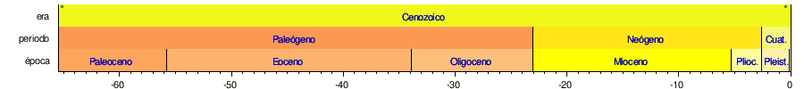
The following table is based on the scale proposed by the International Commission on Stratigraphy (ICS), updated as of 2016.
- For a more detailed version of this table, see Geological Time Scale.
| Eon | It was | Period | Época | M. years ago | Main events |
|---|---|---|---|---|---|
| Fanerozoic | Cenozoico | Quaternary | Holocene | The end of the Ice Age and the emergence of the present civilization | |
| Pleistocene | Cycles of glaciers. Human evolution. Extinction of megafauna | ||||
| Neogen | Plioceno | Formation of the Isthmus of Panama. Ice cap in the Arctic and Greenland. Climate similar to the current one. Australopitecos | |||
| Miocene | Desecration of the Mediterranean. Rule of Antarctica | ||||
| Paleogen | Oligoceno | Orogenia Alpina. Formation of the Antarctic Circumpolar Current and Antarctic freeze. Modern families of animals and plants | |||
| Eocene | India is colliding with Asia. Maximum thermal of the Paleocene-Eocene. Decrease in carbon dioxide. Eocene End Extinction | ||||
| Paleocene | Current look continents. Uniform, warm and humid weather. Animal and vegetable bloom | ||||
| Mesozoic | Cretaceous | ~145,0 | Maximum dinosaurs. Primitive placental mammals. Massive Extinction of Cretaceous-Terciario | ||
| Jurassic | Mammal marsupials, first birds, first plants with flowers | ||||
| Triassic | Mass extinction of the Triassic-Jurassic. First dinosaurs, oviparous mammals | ||||
| Paleozoic | Permico | Pangea training. Mass extinction of the Pérmico-Triassic, 95% of the species disappear | |||
| Carboniferous | Pennsylvania | Abundant insects, first reptiles, fernish forests | |||
| Mystery | Early large trees | ||||
| Devon | The first amphibians, Lycopsida and Progymnospermophyta appear | ||||
| Silurico | First fossil land plants | ||||
| Ordovici | They dominate the invertebrates. Mass Extinctions of the Ordovicico-Silurico | ||||
| Warm | Factory expansion. First fish. Massive Extinctions of the Ordovic War | ||||
| Proterozoic | Neoproterozoic | Ediacárico | Pannotia training. Metazoan fossils | ||
| Criogenic | ~720 | Snowball Earth | |||
| Tonic | Acrylic fossils | ||||
| Mesoproterozoic | Stem | Training of Rodinia | |||
| Ects | Possible red algae fossils | ||||
| Calymic | Expansion of continental deposits | ||||
| Paleoproterozoic | Estatérico | Oxygenic atmosphere | |||
| Orosirico | Biota francevillense | ||||
| Risual | Huronian Glacier. | ||||
| Sidérico | Great Oxidation. First eukaryots. | ||||
| Arcaico | Neoarchaico | Oxygenic photosynthesis. Older crackers | |||
| Mesoarcaico | First glacial | ||||
| Paleoarcaic | Beginning of anoxygenic photosynthesis and first possible fossils and stromatolytes | ||||
| Eoarcaico | First supercontinent, Vaalbara. | ||||
| Hádico | ~4600 | Formation of the Earth |
Notes
- ↑ (a) The Hadic, Arcaic and Proterozoic Eons are grouped in Precambical Time, also called Criptozoic.
- ↑ (b) All dates are given in millions of years for the beginning of the time in question. The dates marked with
 are approximate and based on international agreements with GSSP. The dates of the Precámbrico, except the beginning of the Ediacárico period, have been set chronometrically by agreement.
 - ↑ (c) A recent ICS proposal intended to eliminate the nomenclature Quaternary and extend the Neogen to the present, but the proposal did not prosper.
- ↑ (d) In North America, the Carboniferous is subdivided into the Mysisipic and Pensilenic periods.
- ↑ (e) Discoveries made during the last quarter of the 20th century have substantially changed the way to see the geological and paleontological events immediately prior to the Cambrian. Nomenclature has not stabilized. The term Neoproterozoic is used here, but other writers could also use other terms such as 'Ediacariano', 'Vendiano', 'Varangiano', 'Precambrico', 'Protocambriano', 'Eocambriano', or they could have extended the duration of the Wardrobe. All these terms are regarded as a subset of the Proterozoic rather than as a period between the Proterozoic and the Paleozoic.
- ↑ (f) The International Screening Commission (ICS), (See: Global Boundary Stratotype Section and Point (GSSP) of the International Commission of Stratigraphy (status 2012-2016), and International Stratigraphic Chart, 2016) does not recognize subdivisions in the Hádic eon, but there is a proposal that is inspired by the lunar geologic time scale that the subdivide in the Imbical erasW. Harland, R. Armstrong, A. Cox, L. Craig, A. Smith, D. Smith (1990). A Geologic time scale 1989. Cambridge University Press.).
The following time lines show the geological time scale: the 1.a shows the full time from the formation of the Earth to the present; the 2.a shows an expanded view of the newest eon; the 3rd most recent era; the 4th most recent period; and the 5th most recent time. The colors are the standards to represent the rocks according to their age of formation on the international geological maps.


Contenido relacionado
El Salvador Geography
San Miguel de Tucuman
Regolith