
Highways and avenues of Caracas

The city of Caracas is home to one of the largest networks of highway in Venezuela, almost all built in the second half of the century XX in the governments of Marcos Pérez Jiménez, Rómulo Betancourt, Raúl Leoni and Rafael Caldera and later expanded and interconnected with other roads. The highways of the country and the great avenues of the city are not designated with a coding or numbering system, but with the names of prominent historical figures. In addition, in Caracas, the distributors or connections between highways also usually have peculiar names, for example, after animals: El Pulpo, La Araña, El Centipés and La Gaviota.
Caracas is connected internally and abroad by highways, with other towns, cities and cities, such as La Guaira, El Junquito, Colonia Tovar, Los Teques, Los Valles del Tuy (Charallave and Santa Lucía), Guarenas and Guatire, in addition to the rest of the country.
The highway system that crosses the city from west to east and its respective branches is known as the Francisco Fajardo Highway, which runs from the southwest of Caracas passing through the urbanization of La Paz and up to Las Adjuntas and Macarao; it has a subbranch that goes to Caricuao; to Petare (Boyacá Interchange) where it connects with the Gran Mariscal de Ayacucho Highway (Petare-Guarenas section). The route from Plaza Venezuela to Las Adjuntas is properly called the Francisco Fajardo Highway, from Plaza Venezuela to the Metropolitan Distributor (Boyacá Distributor) Its name is Autopista del Este (it is worth making a difference with the Prados del Este Highway, known as Caracas - Baruta, which is a branch of it that starts at the height of Urb. Las Mercedes and connects with Prados del Este and La Trinidad).
In the La Yaguara sector, to the southwest of the capital, the road to El Junquito begins, which connects that town and Colonia Tovar with the city of Caracas. It also has two branches, one that starts from Catia (passing through the Urdaneta and El Amparo neighborhoods) and another that starts from Mamera (opened in 2007).
Avenida Boyacá (Cota Mil) also ends at the Metropolitan Distributor in Petare, which is characterized by walking the skirts of Cerro Ávila at an average height of 1000 meters above sea level; The Cota Mil unites several urbanizations of Caracas, and is born in the Baralt Distributor where the avenue of the same name ends. Boyacá avenue has a special character, it is practically considered a highway due to its speed limits and traffic restrictions, since cargo trucks and motorcycles are not allowed. It has an unfinished section from the Avenida Baralt interchange that would connect with the beginning of the Caracas - La Guaira highway. Said section in the future is expected to connect it with the Second Caracas-Litoral Highway, which will directly connect the Simón Bolívar International Airport with the Capital.
The Petare - Santa Lucía and Petare - Guarenas highways also originate from the Metropolitan Distributor, roads that despite being old, continue to be widely used due to the lack of new alternate roads.
In the Turgua area, El Hatillo municipality, there is a very steep road to Santa Lucía, which represents a third alternative to go from Caracas to Valles del Tuy (the other two are the Petare - Santa Lucía highway and the branch of the Autopista Regional del Centro that starts from the Los Totumos Distributor (km 31) to Charallave and Santa Teresa - Santa Lucía).
In the Colinas de Bello Monte urbanization, the old Caracas - Baruta highway begins, another alternate road that despite its age is an alternative to go to this part of Miranda state; This road intersects in the El Guire sector in Santa Fe and joins the Caracas - Baruta highway through the Santa Fe interchange, built in 1996, and from there it continues its journey until it reaches the sector known as Las Minas de Baruta. divides into a branch that goes to El Hatillo, and the other continues to the Hoyo de la Puerta sector where it connects with the Autopista Regional del Centro or Autopista Caracas-Valencia.
Main Highways

- Autopista Prados del Este
- Autopista Caracas-La Guaira
- Autopista Francisco Fajardo (Officially Grand Cacique Guaicaipuro Chief of Chiefs)
- Autopista Valle-Coche
- Eastern Autopist
- North-South Autopath
- Regional Autopista del Centro (a section)
- Autopista Gran Mariscal de Ayacucho (a stretch)
Main avenues
- Av. Morán
- Av. Guzmán Blanco (Cota 905)
- Av. Guzmán Blanco (Coche)
- Av. Casanova
- Av. Abraham Lincoln (Bulevar of Sabana Grande - Peatonal)
- Av. Bolivar (The Longest Avenue in Caracas in Straight Line)
- Av. Simon Bolivar (city ridge)
- Av. University
- Av. Baralt
- Av. Sucre de Catia
- Av. Boyacá (Cota 1000)
- Av. Urdaneta
- Av. Andrés Bello
- Av. Lecuna
- Av. Pantheon
- Av. Libertador (the lower level has the Uracoa murals of Mateo Manaure and the Ravelo Cromatic Modules). It covers the municipalities Libertador del Distrito Capital and Chacao del Estado Miranda.
- Av. Francisco Solano López
- Av. Francisco de Miranda the longest in the metropolitan area of Caracas, covering the municipalities Chacao and Sucre of the State Miranda)
- Av. Páez
- Av. O'Higgins
- Av. San Martín
- Av. Tehran (known as Avenida Intercomunal Montalbán-La Vega)
- Av. The Acacias
- Av. Las Palmas
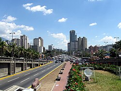 Avenida Bolívar, Caracas
 - Av. Armed Forces (with stations and the BusCaracas system)
- Av. New Granada (with stations and the BusCaracas system)
- Av. President Medina (Also known by his previous name: Av. Victoria)
- Av. Roosevelt
- Av. Ppal. De Maripérez
- Av. Ppal. del Cementerio
- Paseo Los Ilustres
- Av. The Acacias
- Paseo Los Proceres (it becomes the Monument to the Proceres, Gran Paseo de la Academia Militar de Venezuela - semipeatonal). Do not confuse with the avenue the Proceres of San Bernardino.
- Av. Rio de Janeiro
- Av. Ppal de las Mercedes
- Av. Ppal de Bello Monte
- Av. Ppal de El Cafetal
- Av. Ppal de La Castellana
- Av. Venezuela de El Rosal
- Av. Tamanaco
- Av. Intervecinal Santa Mónica-Cumbres de Curumo (Atraviesa the municipalities Libertador del Distrito Capital and Baruta del Estado Miranda)
- Av. Raul Leoni (Boulevar de El Cafetal)
- Av. Sanz
- Av. Mexico
- Av. Ppal de Caurimare
- 4th Av. de los Palos Grandes
- Av. St. John Bosco
- Av. Luís Roche
- Av. Sucre of the Two Ways
- Av. The Castaños of the Chorros
- Av. Rómulo Gallegos
- Av. Ppal de Macaracuay
- Av. The Guairita
- Av. Intercommunal de El Valle
- Av. Ppal de Caricuao
- Av. Ppal de La Hacienda
- Av. Internal of the UCV
- Av. Minerva

Tunnels
| Main Twin Tunnels of the Urban Autoptists of Caracas | |||
|---|---|---|---|
| # | Name | Length | Opening |
| 1 | Tunel El Valle | 1200 m | 1968 |
| 2 | Tunel The Paradise | 900 m | 1967 |
| 3 | Boquerón 1 | 1800 m | 1953 |
| 4 | Tunel Boquerón 2 | 500 m | 1953 |
| 5 | Tunel The Trinity | 200 m | 1974 |
| 6 | Tunel La Planicie | 800 m | 1959 |

| Control of authorities |
|
|---|
 Data: Q2893153
Contenido relacionado
Tultepec Municipality
Fiji flag
Fukushima Prefecture