
Guadalajara Province
The province of Guadalajara is a Spanish province belonging to the autonomous community of Castilla-La Mancha. It has its capital in the homonymous city of Guadalajara.
Its population is 261,995 inhabitants (INE 2020), with a density of 21.53 inhabitants/km²; 33.31% of them live in the capital. There are 288 municipalities in the province, of which 224, 77.78%, have fewer than 200 inhabitants. The most populated town after the capital is Azuqueca de Henares, with 35,000 inhabitants and an industrial center in the province. Other towns such as Sigüenza or Molina de Aragón are important economic centers of the region to which they belong. The province borders Soria to the north, Zaragoza to the northeast, Teruel to the east, Cuenca to the south, Madrid to the west and Segovia to the northwest.
It has its origins in the Provincial Council of Guadalajara with Molina, the first provincial council created in accordance with the Constitution of 1812, constituted in 1813 in Anguita, inside the small palace that is currently the town hall.
Geography

The province of Guadalajara is almost completely included in the Tagus river basin, except for a small area to the northeast that pours its waters into the Ebro basin. Its borders to the north are the provinces of Segovia, Soria and Zaragoza, to the east the latter and that of Teruel, to the south that of Cuenca, and that of Madrid to the west.
Its perimeter can be started at the port of Somosierra (locality belonging to the province of Madrid), and adopting the dividing line of the Jarama and Duero river basins and that of the Ayllón and Sierra de Pela mountains, march leaving Madrigal and Paredes to the south, and Alpanseque to the north (belonging to Soria, although it was once part of Guadalajara); It then continues to the north of Olmedillas, and from the source of the Henares river, it continues through the Sierra Ministra, and from there it heads south through Esteras and Benamira, Arbujuelo, Chaorna and Judes, until it reaches the Aragón line in front of Sisamón. The eastern limit starts from here along the line that in the past divided Aragón from the Molina manor, until it reaches the Sierra de Albarracín in an intermediate spot at the source of the Tagus, Júcar, Cabriel and Guadalaviar rivers. From this point the southern limit begins, and goes along the right of the Tagus until the confluence of the latter with the Oceseca, where it turns left and leaving Valsalobre to the south, Recuenco, Castilforte and Salmerón to the north, heading towards the river Guadiela and by the margin of this it continues walking until in front of Buendía. Leaving this town in the province of Cuenca, it climbs the limit that, tracing it, goes to the summit of the Sierra de Altomira, touches the hermitage of this name, and continues to an area to the north of the source of the Calvache river. The line that limits the province to the west begins there, and taking a northern direction between Leganiel and Illana crosses the Tagus, goes between Driebes and Brea, and leaving Mondéjar to the southwest, passes the Tajuña between Loranca and Pezuela, walks west of Pioz between Pozo and Santorcaz, and cutting the Henares, takes Azuqueca to the west, Camarma and Ribatejada to the east, El Casar to the west and Paracuellos and Valdepiélagos to the east. After fording the Jarama between Uceda and Torremocha, take its right bank which takes you to the place called Pontón de la Oliva, near where that river joins the Lozoya at the beginning of the canal that enriches Madrid with its waters from Torrelaguna..

Geology

The Iberian Peninsula is organized around the Iberian or Hesperian Massif, formed at the end of the Paleozoic, and composed of the granitic roots of the mountain ranges that were formed during the Variscan orogeny, of a dominant NW-SE direction, and previous folded sediments and metamorphosed by it. At the end of the Permian and the Mesozoic, two stages of rifting occurred and the razing of the Variscan mountain range, forming a peneplain on which sedimentation occurs in marine carbonate platform environments. During the late Eocene to the early Miocene, the alpine orogeny occurs, responsible for the main lines of the current relief, due to the uplift of the fractured blocks, as occurs with the Central System, according to thick-skinned tectonics, with reverse faults, limiting pop-up and pop-down type blocks, and the Iberian System, characterized by a thin-skinned tectonics, due to tectonic inversion of the structures of the rifting Mesozoic, giving rise to Appalachian reliefs.

With the appearance of these reliefs, a series of inland sedimentary basins were identified, which accumulated marl, clay and limestone and became clogged in the Pontian (Upper Miocene) with limestone. After the end of the orogeny, the peninsula undergoes a series of epirogenic readjustments that end up tilting the massif to the west. This overturning allows inland lakes to empty and intense erosion of Cenozoic sediments begins.

In the municipality of Fuentelsaz, the International Union of Geological Sciences has established the section and stratotype point of the global limit of the Aalenian floor (the oldest of the Middle Jurassic), a world reference for this chronostratigraphic unit of the geological time scale.
Relief
The province of Guadalajara is located northeast of the autonomous community of Castilla-La Mancha on the central plateau, between the parallels, 40° 07' and 41° 18' N and the meridians 1º 32' and 3º 29' west longitude. With an extension of 12 190 km², it occupies 3.42% of the surface of Spain.


The relief of the province, broadly speaking, is very simple; It is resolved with two mountainous systems, the Central System and the Iberian System, welded together and an interior plateau, cut by the riverbeds.
The province of Guadalajara can be divided into four characteristic units:
- Central System
It occupies the north-western area with the alignments cut by the headwaters of the rivers: The Somosierra, Ayllón, Pela mountains with the Ocejón mountain range from 1500 to 2000 m altitude, and the Alto Rey and La Sierras Bodera between 1,200 and 1,500 meters, which connect to the east through the Barahona and Radona heights with the Iberian System. It is a mountainous system rejuvenated by the alpine orogeny, which separates the two sub-plateaus, borders with Segovia and the Community of Madrid. They are quartzite mountains formed in the Primary era and where the highest heights of the province are found.
The Pico del Lobo, located in the Ayllón massif, is, at 2,262 meters high, the highest peak of this and the autonomous community.
- Iberian system
It occupies the northeastern area, which is resolved to the south by the Sierra de la Umbría, to the southeast by the Albarracín massif, the Molina and Montes Universales mountains (1600 m) and to the north and northeast by the Sigüenza parameras, Atienza and Molina (1050 to 1200 m). To the east it enters the Calatayud-Daroca-Teruel depression. They are mostly limestone mountains, eroded by the gorges of the rivers, and the typical grindstones (such as Tetas de Viana) and parameras.
- We'll be in the car.
Of continental sediments and tabular structure that occupy a good part of the province, its altitude is around 1000 meters.
- Campiñas de los ríos Henares, Sorbe y Jarama
They occupy the western province. The surfaces of the rañas are found in the Henares-Jarama interfluve.
Hydrography

Most of the territory of the province of Guadalajara, 4686 km², is drained by rivers belonging to the Tagus hydrographic basin, a river that discharges its waters into the Atlantic Ocean.
The northeast of the province, with an area of 996 km², belongs to the Ebro river basin, which flows into the Mediterranean. It includes a territory, which pours its waters into the endorheic basin of Gallocanta.
Atlantic side

The rivers that discharge their waters into the Atlantic Ocean, through the Tagus basin, have the following hydrological regime:
- Tajo-Gallo river system, which occupy the eastern part of the province, with a rain-nival regime.
- Tajuña River Basin, with an extension of 2,015 km2, and the Henares basin, with 3,735 km2 of extension and that of the Jarama river with 782 km2, which collect the waters of the western zone, with a north-south orientation, have in general a Mediterranean rain-nival regime, although the rivers located towards the Central System (Sorbe and Jarama), accuse in their headers a Nivo-Pluvial regime.
Mediterranean side
The rivers that have their source in the province of Guadalajara and discharge their waters into the Mediterranean are the Piedra and Mesa rivers, tributaries of the Jalón river, of the Ebro hydrographic basin. A small part of the province also discharges its waters in the endorheic basin of the Gallocanta lagoon.
Aquifers
The province of Guadalajara has a very important groundwater system, made up of seven aquifers, most of which belong to the Tagus basin, but also participate in the Duero and Ebro basins.
.png)
- Aquifer No. 10, called "Mesozoic karstic unit".
- This aquifer has an area of 3100 km2 and extends, mainly in the Duero basin. In the province of Guadalajara occupies the north end, in the mountains of Atienza, Pela and Minister, occupying an extension of 350 km2.
- Aquifer No. 17, called "Mesozoic Retreat of Guadarrama".
- It is the smallest aquifer in the province, 60 km2, it belongs in its entirety to the Tagus basin.
- Aquifer No. 18.1, called "Mesozoic of the western flank of the Ibérica".
- Aquarius No. 18.2, called "Tajuña-Montes Universales".
- It is located in the Tagus and Jucar basins, comparing it with the province of Cuenca, with a total area of 17,400 km2.
- Aquifer n.o 57, called "Mesozoic of Monreal-Gallocanta".
- It is located in the basins of Tajo, Ebro and Júcar; Guadalajara occupies an area of 700 km2.
- Aquifer n.o 15, called "calizas of the Alcarria slum".
- It is the only aquifer that is mostly located in the province, and also the most extensive, 1600 km2, is located between the Henares, Jarama and Tajo rivers, being its natural drainage of the Tajuña River.
- Aquifer n.o 14, called "Detritic Court of Madrid, Toledo-Cáceres".
- Pertenecent to the Tagus basin, in Guadalajara occupies a very small space, southwest of the province.
- Aquifer No. 19, called "Highmira's limestone unit".
- It extends to the south of the province, continuing to that of Cuenca, with an extension of 2700 km2.
Climate

The province of Guadalajara, given its wide and varied geographical reality, gathers in its territory various climatic conditions, although all of it can be framed within the so-called continental Mediterranean climate, typical of the Central Plateau, which is especially pronounced in the regions of higher altitude (the Serranía, Señorío de Molina-Alto Tajo and Alcarria Alta) and that softens in the lower ones (Campiña and Alcarria Baja).

Long, dry and hot summers, and equally long and harsh winters, give way to springs and autumns that are short and temperate in their meteorological conditions, but that leave a significant imprint of their equinoctial seasonality in the landscape, both in the stage of foliation as well as deciduous foliage of arboreal plant species.
The climatic diversity of the province of Guadalajara, located in a transition zone between Atlantic and Mediterranean Spain, favors the development of very different plant communities (holm oak, juniper, pine, oak or beech forests) that are made up of rich and various ecosystems.
Some municipalities in the province of Guadalajara, such as Molina de Aragón, are published as the towns with the coldest winters in all of Spain. On January 28, 1952, -28.2 °C was reached in said municipality.
Precipitation
.png)
The seasonal distribution of rainfall is conditioned by the relief, the maximum rainfall occurs in the mountainous areas of the Iberian System, between 700 and 900 mm per year, and in the headwaters of Jarama and Sorbe, in the Sierra de Ayllón, with more than 800 mm.
There are three areas with rainfall less than 600 mm:
- The West, which includes the valleys of the Henares, Tajuña and south of the Tagus valley.
- The eastern, towards the depression of the Jiloca, in the basin of the Stone River.
- The north, on the Sigüenza paramera, on the border with the Altos de Barahona and Radona.
These areas include a large part of the Alcarrias de Brihuega and the Alcarrias del Sur, Mondéjar and Pastrana.
Finally, there are areas with rainfall of less than 500 mm, which are included in the above are:
- The Henares Basin.
- The Alcarria de Mondéjar.
- The south of the Tagus valley in the west of the province.
- The sotavento region of Molina's paramera is an area with rainfalls below 400 mm, bordering the provinces of Zaragoza and Teruel, in the Gallocanta endorreica basin.
Flora


The geographical space of the province of Guadalajara presents a great variety of plant landscapes, the result of a combination of ecological and anthropic factors.
The provincial territory covers 1,219,040 hectares, with 24.7% of this area being wooded, with 145,585 hectares of coniferous trees and 155,775 hectares of hardwoods.
Within the replacement broadleaved and shrubby tree masses, the following formations can be distinguished:
- Encinars (Quercus rotundifolia): the oak covers the entire provincial space with 63 480 hectares, with the exception of certain enclaves of higher altitude. In some areas the oak has yielded its natural space to dry crops or pine repopulations. It consists of arboreal formations accompanied by bushes such as rosemary, jars, thyme, cantueso, spliego and sage.
- QuejigaresQuercus faginea): alternating with the holm oaks and sabinars the province has a wide range of cherries, 40 387 hectares, especially on land between 800 and 1200 meters of altitude. They appear accompanied by serbales and thorny bushes.
- Melojares (Melojares)Quercus pyrenaica): the bleach oaks occupy a smaller and largely highly modified and degraded extension. They appear mainly in the Ayllón massif and in the border mountains of the province. The peach oak is usually accompanied by acebo, serbal and in the clear areas of the woods by brezos and jarales.
- Hayedos.Fagus sylvatica): the nests are reduced to the Ayllón mountain range, mainly in the Tejera Negra estate, which has comprehensive protection.
Among the masses of conifers, these formations can be distinguished:
- Pinares: they occupy a large extent of the province, the result of an intense repopulation policy that has led to the substitution of the lush masses on numerous occasions. There are many existing pine species, the most abundant is the bare pine (Pinus nigra) that predominates in the northwest of the province. Second is the resin pine (Pinus pinaster) especially present in mountainous areas of Molina de Aragón. The wild pine (Pinus sylvestris), extends through the north-west and south-east sector of the province, while the carrasco pine (Pinus halepensis), has isolated stains south of the province.
- Sabinares: the savannah albar is the genuine forest of Guadalajara's parameras. It occupies the llanes (100-1400 m) and the slopes exposed to the most rigorous weather conditions. In the term of Torremocha del Pinar there is a magnificently preserved sabinar, and in more precarious conditions, there is also a formation of sabinar in Tamajón.
In addition to these wooded formations, the banks of the numerous rivers that cross the province are present with species as significant as ash, elm, alder, and birch, which grow alongside reedbeds and rushes (riverside vegetation).
Wildlife
Given the variety of ecosystems that the province of Guadalajara presents, the fauna that inhabits them is really interesting and polymorphous. In wetlands, in rivers and on their banks, in mountainous areas, between Atlantic and Mediterranean-type forests, between coniferous forests, in the moors and steppes or in the underground ecosystems that occur in the province of Guadalajara There are different fauna species, among which are:
.png)
.png)
- Mammal climbers: montés cat, gineta, garduña, badger, turon, weasel and fox. A mustelid like the otter usually breeds in the most aggressive and inaccessible stretches of rivers such as the Tajo, Sorbe, Jarama and Dulce, among others.
- Mammals of kinegotic interest: private cotos, intensive film farms, social cotos, reserves and controlled hunting areas regulate and enable the practice of hunting in almost all municipalities of the province.
- Caza mayor: Jabalí (with spots spread throughout the province), corzo (especially abundant in the National Reserve of Caza de Sonsaz, northwest of the province), deer (especially present to the southeast of the province, within or near the Caza de los Montes Universales)
- Smaller hunt: Abundant throughout the provincial territory, with special presence of rabbits and hares, perdices, codornics, doves and tortoles, as well as aquatic birds such as the real adea and the frieze, the coloured duck, the spoon duck, the Common and moñudo porn, the common cerceta or the focha.
- Ictiofauna: the abundance of river courses (more than 1000 kilometers of fishable rivers) and the succession of artificial reservoirs and natural lagoons that are given in the province, promote a wide, rich and varied ictiofauna, among which stand out indigenous salmonids such as the common trout and implanted as the rainbow trout and ciprínidos like the barbo, the bonga. In the reservoirs of Entrepeñas, Buendía and ballrque have ideal habitats fishing species as appreciated as the lucio, the black-bass and the tent. Intensive, experimental and controlled fishing charters, managed directly by the Administration or in collaboration with fishing companies, are located in stretches of rivers such as the Tagus, Gallo, Jarama, Sorbe, Tajuña, Dulce, Henares and Cifuentes.
.jpg)
- Protected aquatic airfauna: frequent in the wetlands of the province, although with a prominent presence in the Almoguera reservoir, declared «Controlled Hunt Zone»: somormujos, zampullines, royal and imperial claws, laguneros eagluchos and cenizos, carriceros or bigotudos. In the lagoons of Puebla de Beleña (northwest), as well as in others that sprinkle the east of the province, they concentrate on their pre-nuptial migratory passage birds like the crane. Abubillas, beejarucos, oropéndolas and fishermen's rallies also integrate Guadalajara's plane. Other travellers such as the white stork occupy nests in churches, tall buildings or groves of the province.
- Birds of prey: In the province we find the presence of almost all Iberian, sedentary or wintering species, both diurnal and nocturnal, all of them strictly protected: vultures leonados (with abundant presence in the Upper Tagus and in the canyons of the rivers Dulce and Salado), alimoches, eagles and perdiceras, halcons pilgrims, cerní
Protected natural areas


The protected areas include:
Natural parks
- High Tajo
- Barranco del Río Dulce
- Sierra Norte de Guadalajara
Nature Reserves
- Lagunas de Puebla de Beleña
- Natural Reserve of the Massif of the Wolf - Cebollera
Micro-reserves
- Cerros Margosos de Pastrana y Yebra
- Volcanic hills of La Miñosa
- Cave of the Canaleja
- Wet Prados of Torremocha del Pinar
- Saladares of the Salado River Basin
Natural monuments
- Cave of the Canaleja
- Sierra de Caldereros
- Pela mountain range microreserve and Somolinos lagoon
- Viana Tits
River reserves
- Pelagallinas River
- Sotos del río Tajo
Others in the Natura 2000 Network
In addition, there are other places included in the Natura 2000 Network:
Places of Community Importance (LIC)
- Volcanic hills of Cañamares
- Yesous Slopes of Tendilla
- Mountains of Picaza
- Quejigales de Barriopedro y Brihuega
- Rañas de Matarrubia, Vilaseca y Casas de Uceda
- Navalpotro Rebollar
- Riberas de Valfermoso de Tajuña y Brihuega
- Banks of the Henares
- Alustante-Tordesilos tracks
- Sierra de Pela
- Cañamares River Valley
- Tajuña Valley in Torresquada
Special Protection Areas for Birds (ZEPA)
- Farmer's cereal steppes
SCIs and SPAs
- Parameras de Maranchón, Hoz de Mesa y Aragoncillo
- Serranía de Cuenca
- Sierra de Altomira
- Sierra de Ayllón
- Valle and Salinas del Salado
Symbols

- Shield
The heraldic shield used by the council is made up of the arms of the heads of the nine historic judicial districts of the province: Atienza, Brihuega, Cifuentes, Cogolludo, Guadalajara, Molina de Aragón, Pastrana, Sacedón and Sigüenza —in the Currently, the province only has three judicial demarcations.
- Flag
The flag of the province is a purple cloth of proportions 2:3 with the provincial coat of arms charged in the center.
History
- Background


The oldest archaeological remains found in the province date from the Mousterian period of the Stone Age (Cueva de los Casares). Later it was occupied by Visigoths (who founded Recópolis), Muslims (from whose passage the castles of Molina and Zorita are preserved) and finally it was reconquered by Christians. Guadalajara reached its maximum splendor with the Mendozas, in the XIV century. At the end of the 18th century it became one of the sixteen provinces of Castile.
- Floridablanca Census
In the Floridablanca Census, a census document prepared in Spain under the direction of the count of the same name, minister of Carlos III, between 1785 and 1787 and is considered the first Spanish population census prepared using modern statistical techniques, the Municipality of Guadalajara is formed by: Guadalaxara party; the Land of Jadraque with the sexmos of Bornoba and Henares, with two exempted towns; the Land of Hita; the Land of Buitrago with two exempted towns; the district of Sigüenza, with the Tierra de Galve, Tierra de la Riba de Santiuste, Tierra de Miedes, and the Tierra de Paredes de Sigüenza; the party of Colmenar Viejo, with the County of Manzanares.
Its limits did not coincide with the current ones since the districts of Colmenar Viejo and Buitrago del Lozoya corresponded to the current province of Madrid, as well as the manor of Real de Manzanares.
- Land reorganizations of the centuries XVIII and XIX
During the period of illustrated reforms 1799-1805, the province of Guadalajara ceded to Madrid the enclaves of Colmenar Viejo, San Martín de Valdeiglesias and Galapagar. Also during this period of territorial reforms, in 1801, the lordship of Molina would go from Cuenca to Guadalajara.
| Judicial parties | Peoples | Neighbors | Souls |
|---|---|---|---|
| Cifuentes | 52 | 4098 | 14 870 |
| Brihuega | 51 | 5666 | 20 255 |
| Guadalajara | 34 | 5437 | 19 414 |
| Fears | 66 | 3393 | 11 793 |
| Molina | 98 | 6889 | 25561 |
| Pastrana | 30 | 5908 | 20 948 |
| Priest | 25 | 4241 | 14 909 |
| Sigüenza | 69 | 4531 | 17 196 |
| Tamajón | 59 | 3999 | 14 009 |
| Total | 397 | 44 142 | 159 044 |
Facing the division of 1822, in force briefly during the liberal triennium, the provincial capital was discussed; the possibilities of locating it in the eventually chosen city of Guadalajara —the most populated, but in a peripheral situation very close to Madrid—, in other localities such as Brihuega and Cifuentes —more central— were assessed; and also in Sigüenza.
When the modern provinces were constituted in 1833 in the new territorial organization of Javier de Burgos, Guadalajara was essentially configured with its current limits and was divided into nine judicial districts, into which 397 constitutional municipalities were integrated. to the region of Castilla la Nueva.
.jpg)
The only change in the limits of the province of Guadalajara after the territorial division of 1833 would affect the small municipality of Valdeavero, measuring 19 km², which became part of the province of Madrid in 1850.
The Demarcation and Judicial Plant Law of December 28, 1988 restructured the structure of judicial districts in Spain and reduced the existing ones in the province of Guadajalara to three.
Territorial organization
Municipalities
Entities of territorial scope inferior to the municipality
_(cropped).png)
Country
- The Alcarria
- La Campiña
- Serranía de Guadalajara
- Señorío de Molina-Alto Tajo
Administration and politics
- Representatives in General and Regional Courts

Historical-artistic heritage
- Sigüenza Castle
- Castillo de Molina de Aragón
- Torija Castle
- Castle of Atienza
- Jadraque Castle
- Castle of Riba de Santiuste
- Castle of Zafra
- Castillo y Murallas de Palazuelos
- Castle of Pioz
- Castle of Galve de Sorbe
- Palace of the Infantado, Guadalajara.
- Palacio de Antonio de Mendoza, Guadalajara.
- Ducal Palace of Pastrana
- Ducal Palace of Cogolludo
- Sigüenza Cathedral
- Concatedral de Guadalajara
- Cueva de los Casares in La Riba de Saelices
- Recopolis site
- Monastery of Monsalud
- Monastery of Bonaval
- Monastery of Lupiana

Molina de Aragón and its castle

Sigüenza Cathedral

Ducal Palace of Cogolludo

Palacio del Infantado de Guadalajara


Demographics

Most of the population is concentrated in the capital, Guadalajara, and its immediate surroundings, which are influenced by the metropolitan area of Madrid. However, the areas of the Serranía de Guadalajara or the Señorío de Molina-Alto Tajo have a very low population density. In fact, 224 municipalities (INE 2018) of the 288 in the province, 77.8%, have fewer than 200 inhabitants, with only 8 having more than 5,000 inhabitants.
Regarding the growth of the population by municipality, a continuous loss is observed from the less densely populated areas in favor of the capital and the area closest to Madrid, further aggravating the situation of depopulation suffered by these regions.
The province of Guadalajara is the 19th in Spain —out of a total of fifty— in percentage of population concentrated in its capital (32.39%, compared to 31.96% for Spain as a whole).
| Graphic of demographic evolution of the province of Guadalajara between 1842 and 2019 |
 |
Rule population (1842-1897, except 1857 and 1860 which is a de facto population) according to population censuses of the centuryXIX.Population of law (1900-1991) or resident population (2001 and 2011) according to population censuses of the INE. Population according to the 2019 INE Municipal Register. |
| The evolution of the urban population of the province between 1787 and 2018 |
 |
Percentage of total urban population (municipalities of more than 10 000 inhabitants), 1787-2018. |

Population by municipality in 2018
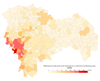
Population density by municipality in 2018
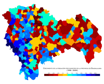
Population growth by municipality between 1998 and 2008

Population growth by municipality between 2008 and 2018


Communications
Given its privileged location in the center of the Iberian Peninsula and the marked radial nature of the Spanish road network, the province of Guadalajara has a wide and complete network of accesses to its territory and internal communication routes, through of any means of transport.
By air
By air, Guadalajara can be accessed through the Madrid-Barajas airport (Madrid), located 45 kilometers from the capital of the province.
By road


The main access road to Guadalajara is the Northeast highway (E-90), which links the capital of Spain with Zaragoza, Barcelona and France, through La Junquera (Gerona). This highway runs through the province from west to east, entering the province of Guadalajara from the Community of Madrid through the municipality of Azuqueca de Henares (km. 43) and leaving it to enter Soria through the municipality of Alcolea del Pinar (km. 133).
From the north, by road, the province can be accessed mainly by the CM-101 (better known as the "Soria road") and the C-114, which links Aranda de Duero (Burgos) with Alcolea del Pinar, entering Guadalajara through the province of Segovia (Santibáñez de Ayllón).
From the south, the main road access to the province of Guadalajara is through the N-320 that, coming from Cuenca, enters Guadalajara through the municipality of Alcocer. This same road, after going through municipalities in the Alcarria and Campiña regions, passing through the capital of the province, enters the Community of Madrid through the municipality of El Casar, later connecting in Valdepiélagos with the C-100 and in Lozoyuela with the Autovía del Norte. Likewise, from the south, the province of Guadalajara can be accessed from that of Cuenca through regional roads through the municipalities of Illana, Poveda de la Sierra and Peralejos de las Truchas.
From the east, the main road access to Guadalajara is through the N-211 that connects Teruel with Alcolea del Pinar, passing through Molina de Aragón.
By rail
The Madrid-Barcelona railway line runs through the province of Guadalajara in a SW-NE direction, with stations in the following municipalities of the province: Azuqueca de Henares, Guadalajara, Fontanar, Yunquera de Henares, Humanes, Espinosa de Henares, Carrascosa de Henares (district of Espinosa de Henares), Jadraque, Matillas, Baides, Sigüenza and Alcuneza (district of Sigüenza).
The Madrid-Zaragoza-Barcelona-French border high-speed line crosses the province, with a station in it, Guadalajara-Yebes.
Media
The province's written press includes Nueva Alcarria, La Crónica de Guadalajara, Guadaqué, GuadaNews, Henares al día and Guadalajara Diario. In the field of television, Guadalajara Media and Guada TV are broadcast.
Notable people
Contenido relacionado
Land
Cadiz Province
Albania