Gorge Bridge
Puente del Congosto is a Spanish municipality and town in the province of Salamanca, in the autonomous community of Castilla y León. It is integrated into the Guijuelo region and the Alto Tormes sub-region. It belongs to the judicial district of Béjar.
Its municipal area occupies a total area of 34.04 km² and according to the demographic data collected in the municipal register prepared by the INE in 2017, it has a population of 227 inhabitants.
Toponymy
The name of Puente del Congosto comes from "Narrow Arch Bridge", referring to the bridge over the Tormes River on the Ávila-Ciudad Rodrigo route, which had a narrow arch of which only one side wall remains today.
Symbols
Shield
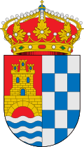
The heraldic shield and the flag that represent the municipality were officially approved on April 30, 2003. The shield follows the following coat of arms:
Match shield. First in the field of gules a gold bridge over silver and azur waves, added to a golden castle cleared of azur. Second skeleton of fifteen pieces, eight silver and seven sugar.Official Gazette of Castile and Leon No. 103 of 2 June 2003
Flag
The flag responds to the following textual description:
Square cloth, 1:1 ratio, vertically divided into three equal stripes, the red central with the Municipal Shield to the center of the cloth and the other two, chessed of fifteen pieces, eight white and seven blue.Official Gazette of Castile and Leon No. 103 of 2 June 2003
Geography
The locality is located at an altitude of 944 ms. no. m.. The municipality is located in the southeast of the province; It adjoins the municipalities of Cespedosa de Tormes, Gallegos de Solmirón Navamorales, Santibáñez de Béjar and El Tejado —also belonging to the province of Salamanca— and with those of Medinilla and Narrillos del Álamo —belonging to the province of Ávila—.
| Northwest: Cespedosa de Tormes | North: Alamo Narrillos | Northeast: Gallegos de Solmirón |
| West: Santibáñez de Béjar |  | This: Navamorals |
| Southwest: Medinilla | South: The roof | Sureste: Navamorals |
History
Middle Ages
The town, which was part of the Tierra de Ávila royal estate, underwent a seignorization process together with Cespedosa, being donated by Enrique III of Castile to Gil González Dávila on November 2, 1393.
Modern Age
In 1539 the town —which at that time belonged to the order of Calatrava— was transferred along with the rest of the villages and places under its jurisdiction to the Duke of Alba, Fernando Álvarez de Toledo.
Contemporary Age
The provincial reorganization of Javier de Burgos in 1833 framed it in the province of Salamanca and the Leonese Region.
The town of Puente de Congosto headed the Manor of the Town and Land of La Puente del Congosto until the abolition of the manors. Said manor was made up of the Villa de Puente del Congosto and three gangs: El Tejado (with its three neighborhoods and Peñaflor, today depopulated), Bercimuelle and Navamorales (which was the head of his gang and included the towns already disappeared from Las Casillas and Berrocosa).
Demographics
The municipality, which has an area of 34.04 km², has 227 inhabitants and a density of 6.67 inhabitants/km² according to the 2017 municipal register of the INE.
| Figure of demographic evolution of Puente del Congosto between 1842 and 2022 |
 |
Rule population (1842-1897, except 1857 and 1860, which is a de facto population) according to population censuses of the nineteenth century. |
Population centers
The municipality is divided into two population centers, which had the following population in 2015 according to the INE.
| Population Core | Population |
|---|---|
| Congosto Bridge | 175 |
| Bercimuelle | 65 |
Monuments and places of interest
Our Lady of the Assumption Church
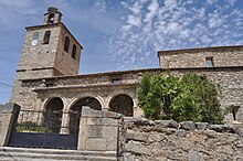
The parish church of Puente del Congosto, consecrated to Our Lady of the Assumption, is a magnificent Gothic building built in the 16th century, probably on top of some primitive temple, and rebuilt in the 16th century, consisting of three naves and the same number of chapels at the head. It is worth noting inside the ribbed vaults of the main altar and the chapel on one side, both from the XVI century, as well as the central altarpiece, from the 17th century, which presides over the main chapel, covered with glued sheets of gold paper, called "gold leaf". Somewhat later, from the XVIII century, are the altarpieces with four other side altars, in Baroque style, as well as the organ, large, located in the choir. In addition to those referred to, there are two other more modern altars. The church also preserves a valuable carved walnut gate, as well as interesting goldsmith objects, sculpture and ecclesiastical clothing. In the sacristy, whose ceiling is very striking, there is another ornate piece of furniture, also made of walnut wood. As for the exterior of the temple, it does not detract from its interior at all. Its artistic façade stands out, all of it made of granite from the area, with three striking stone arches.
Dávila Castle
The origin is between the 12th century or XIII, to protect the bridge on the Ávila - Ciudad Rodrigo route. In 1393 Enrique III grants Gil González Dávila the dominion of the Puente del Congosto, which he reconstructs and continues to this day.
In 1485 Pedro de la Gasca was born, great-great-grandson of Gil González Dávila, who was commissioned by Emperor Charles V to put down Pizarro's rebellion in Peru.
In 1497, Queen Isabella the Catholic, being in this castle, was informed of the death of her son, the Prince of Asturias.
Emperor Charles V also stayed at the castle on his way to retirement in Yuste.
The castle and the town passed into the hands of the Dukes of Alba. In 1809 French troops occupied it for two years.
Its plan, demarcated by the perimeter wall, is an irregular hexagon. It can be covered, in its upper part, practically in its entirety, by a coastal path. The current entrance to the enclosure gives direct access to a spacious open-air parade ground, partially paved with granite slabs.
It is currently private property.
Administration and politics
Municipal elections
| Political party | 2019 | 2015 | 2011 | 2007 | 2003 | ||||||||||
|---|---|---|---|---|---|---|---|---|---|---|---|---|---|---|---|
| % | Votes | Councillors | % | Votes | Councillors | % | Votes | Councillors | % | Votes | Councillors | % | Votes | Councillors | |
| Popular Party (PP) | 47,46 | 84 | 3 | 71.12 | 133 | 4 | 62.89 | 122 | 5 | 23,29 | 51 | 1 | 53,78 | 135 | 4 |
| Spanish Socialist Workers Party (PSOE) | 37,29 | 66 | 2 | 24,60 | 46 | 1 | 36,08 | 70 | 2 | 25,11 | 55 | 2 | 27,09 | 68 | 2 |
| Union of the Salmantino People (UPSa) | - | - | - | - | - | - | - | - | - | 50.23 | 110 | 4 | 19.12 | 48 | 1 |
Transportation
The municipality is well connected by road, being crossed by two important roads; in Bercimuelle the SA-104 that connects to the west with Guijuelo, through the new bridge over the Santa Teresa reservoir and to the east with Gallegos de Solmirón and Ávila; In Puente del Congosto it is the SA-102 highway that crosses the town, connecting to the west with Sorihuela and the connection to the N-630 and to the east with Navamorales and the province of Ávila. It is therefore possible to access the highway through both roads, both being accesses to the Ruta de la Plata highway that connects Gijón with Seville and allows rapid communication between the municipality and the rest of the country. On the other hand, the two nuclei that make up the municipality are linked together by a local paved road.
As far as public transport is concerned, after the closure of the Vía de la Plata railway route, which passed through the municipality of Guijuelo and had a station there, there are no train services in the municipality or in the neighbors, nor regular line with bus service, the closest station being Guijuelo. On the other hand, Salamanca airport is the closest, being about 74km away from the municipal capital. There is also an aerodrome with a dirt track for recreational use in Bercimuelle.
Contenido relacionado
Ashwoody
Eritrean flag
Navarre (disambiguation)


