
Glacier


A glacier (from the French glacier) is a thick mass of ice and snow originated on the Earth's surface by accumulation, compaction and recrystallization of snow, showing evidence of past or present flow. Their existence is possible when the annual snowfall exceeds that melted in summer, which is why most of them are found in areas near the poles, although they exist in other areas, in mountains. The process of glacier growth and establishment is called glaciation, although this term is usually reserved to describe cold periods in Earth's history in which abundant ice masses and glaciers formed. The world's glaciers are varied and can be classified according to their shape, whether they are valley, niche, ice field, or by climatic regime such as tropical, temperate, or polar, or cold-base, hot-base, or polythermal thermal conditions.
10% of the Earth is covered by glaciers, and in recent geological times that percentage reached 30%. The world's glaciers accumulate more than 75% of the planet's fresh water. Currently 91% of the volume and 84% of the total area of glaciers is in Antarctica, 8% of the volume and 14% of the area in Greenland adding the rest of the glaciers 4% of the area and less than 1% of the volume.
The polar caps, continental glaciers or inlandsis, are the largest glaciers that currently exist on Earth. They occupy a total of 15 million km², which means 90% of the areas covered by ice. The Antarctic ice sheet is the most extensive.
Training

Glaciers are a product of climate and are constantly exchanging mass with other parts of the hydrological system. Glaciers grow with the addition of snow and other types of ice and lose mass through melting of ice into water, evaporation (sublimation) and the dismemberment of ice floes. The difference between mass gains and losses of a glacier is called the glacier balance. When the mass balance is negative, the glacier loses mass and when it is positive, it gains mass as it grows. The mass of a glacier is called accumulation and loss ablation.
The main forms of accumulation are direct precipitation of snow, frost, freezing of liquid water, snow transported by winds, snow and ice brought by avalanches, lightning strikes, and freezing of water in the basal layers. Glaciers usually draw an imaginary line called equilibrium line which divides the glacier in question into two zones, one of accumulation and one of ablation in net terms.
Glacier ice formation
In places of a glacier where the accumulation of snow is greater than the ablation, snow accumulates from year to year and the deeper layers of snow are transformed into glacial ice. The transformation into glacial ice is It is due to two processes, one of compaction and the other of metamorphism. The speed of transformation depends on humidity and temperature. Snow crystals that precipitate on a glacier have shapes ranging from hexagons and needles to more complicated ones, but these forms are unstable when accumulating either on a glacier or elsewhere and evaporate in areas of high exposure and receive condensation in more sheltered places, which ends up giving them a rounder appearance. Before becoming glacial ice the Snow turns into sleet, which is essentially snow that has survived for at least a year.
On glaciers, where melting occurs in the snowpack zone, snow can turn to ice through melting and refreezing (over periods of several years). In Antarctica, where melting is very slow or non-existent (even in summer), the compaction that turns snow into ice can take thousands of years. The enormous pressure on the ice crystals causes them to have a plastic deformation, whose behavior causes the glaciers to move slowly under the force of gravity as if it were a huge flow of earth. This ice cap in Antarctica is classified as polar or cold because it is completely refrigerated, because it is located at the pole and because it does not go through a summer melting season since summer is almost non-existent.

The size of glaciers depends on the climate of the region in which they are located. The balance between the difference between what accumulates at the top and what melts at the bottom is called glacial balance. In mountain glaciers, the ice is compacted in cirques, which would be the accumulation zone equivalent to what would be the basin for receiving torrents. In the case of continental glaciers, the accumulation also occurs in the upper part of the glacier, but it is one more result of the formation of frost, that is, the direct passage of water vapor from the air to the solid state due to the low temperatures of the glaciers, than by snowfall. Accumulated ice compresses and exerts considerable pressure on the deeper ice. In turn, the weight of the glacier exerts a centrifugal pressure that pushes the ice towards its outer edge where it melts; this part is known as the ablation zone. When they reach the sea, they form icebergs by breaking up over ocean water, as can be seen in a Google maps satellite image of Melville Bay, northwest of Greenland. In valley glaciers, the line that separates these two zones (accumulation and ablation) is called the snow line or equilibrium line. The elevation of this line varies according to the temperatures and the amount of snow fallen and is much higher on the sunny slopes or slopes than on the shady ones. It is also much larger in the leeward than in the windward.

The glaciers of Greenland and Antarctica are much more difficult to measure, since the advances and retreats of the front can be offset by a greater or lesser accumulation of ice at the top, presenting a kind of cycles of advance and retreat that mutually feed back giving rise to a dynamic compensation in the dimensions of the glacier. In other words: a decrease in the height of the Antarctic glacier, for example, could generate a greater outward push, and at the same time, a greater margin for a similar amount of ice to accumulate again than previously existed.: Let's remember that this height (about 3 km) is determined by the glacial balance, which has a kind of certain ceiling on which no more ice can accumulate due to the low amount of water vapor that the air has at high altitudes (for usually above 3,000m).
Classification
There are several ways to classify glaciers. Regarding rock glaciers, there is a dispute as to whether they should be considered glaciers or not.
According to temperature
The ice of glaciers is usually distinguished into warm ice that is at melting temperature and cold ice that is below this temperature. This classification has been extrapolated to entire glaciers with the following categories as a result:
- Tempered glacier: is the one who is, with the exception of the surface layers, at the fusion temperature (approximately).
- Subpolar glacier: are those that are tempered in their inner but cold parts on their edges.
- Polar glacier: are those who are entirely under the fusion temperature. In this case, it is the high pressure that is derived from the very weight of the ice, which keeps the water frozen.
In reality, this classification of glaciers is not very functional because it is a more complex phenomenon than it seems. For example, polar glaciers are not the only ones in which the temperature of the glacier mass is below the melting point. Also in mountain glaciers, even in the intertropical zone, they are in this situation, although their mass, thickness and pressure that they support is much less than in polar glaciers. All this must be taken into account, because in the latter case they have given rise to landslides or avalanches of enormous proportions and tragic consequences, as happened in the Ranrahirca and Yungay floods in Peru and Armero in Colombia. In the case of Peru, the catastrophes of Ranrahirca (January 10, 1962) and Yungay (May 31, 1970) had seismic reasons, since the earthquakes were the cause of the violent detachment of large masses of the Huascarán glacier. And in the case of Armero, the reason was a volcanic eruption of Nevado del Ruiz on November 13, 1985. For a certain time before the Armero tragedy, the volcano was in eruption, which caused the progressive heating of the base of the glacier, which retained its solid state (for the reason already indicated that ice is a poor conductor of heat) but, when said base melted, it acted as a lubricant and produced a catastrophic alluvium or detachment of ice, water, earth, rocks and trees (lahar) that devastated the city of Armero causing more than 20,000 deaths.
According to morphology
One way is to classify glaciers by their morphology, although it must be kept in mind that there is a continuum between the various morphologies and that each glacier is unique. Based on previous morphological classifications, glaciologists Douglas Benn and David Evans have classified glaciers in:
- Ice mantle and ice caps. This type of glaciers covers the entire landscape at least in its central parts and its flow is largely independent of the topography below.
- Ice dome
- Exhutorio glacier: Morphologically, effluent glaciers occupy depressions of the glacier bed and laceeded valleys, breaking the rocky base by effects of the action of the ice on the margins of the ice fields and are limited by ice-free land.
- Ice current
- Glaciers controlled by the topography.
- Ice field
- Valley glacier
- Transsection glaciers
- Circus Glacier
- Parademonte lobe
- Glaciarete
- Ice apron (Ice lining)
- Ice Strip
- Marine glaciers. These glaciers are formed when a glacier is forced to float on water or when sea ice is thickened by surface accumulation or acreation below.
- Ice elevation
- Glacier ice platform
- Marine Ice Platform
Hydrology
Since glaciers are made of water, they are part of the hydrological cycle. Glaciers act as water reservoirs that retain part of the precipitation. The world's glaciers hold 68.7% of the Earth's fresh water. Liquid water from glaciers can come from two sources: melting snow or ice or directly from rain. The internal hydrological system of a glacier is complex, varying from percolation sites to systems of tunnels, crevasses and caves.
There are various ways in which liquid water can be stored within a glacier such as snow and firn, crevasses, supraglacial lagoons, englacial and subglacial cavities apart from the subglacial and englacial drainage system as well as subglacial sediments. Glaciers affect the hydrology of watersheds even in basins where the glaciated surface is small. Glacier discharge is usually seasonal, being highest in summer.
In the case of temperate glaciers, these are covered by snow at melting temperature in late spring. In temperate glaciers, meltwater percolates through the firn until it reaches a level where the firn is saturated with snow. liquid water. This water is prevented from percolating further by the ice below the firn in glaciers, which is practically impermeable. This ends up forming an open aquifer in the firn. The thickness of the aquifer will depend on the efficiency of glacial drainage and also of hydraulic gradient. In firn easts approximately 40% of the pore space can be occupied by water with the remaining 60% occupied by trapped air.

Movement

Ice behaves like a brittle solid until its accumulation reaches 50 meters in thickness. Once this limit is exceeded, the ice behaves like a plastic material and begins to flow. Glacial ice consists of layers of molecules packed on top of each other. The bonds between the layers are weaker than those within each layer, so when the stress exceeds the forces of the bonds that hold the layers together, they move over each other.
Another type of movement is the basal glide. This occurs when the entire glacier moves over the terrain on which it is located. In this process, the melt water contributes to the displacement of the ice through lubrication. Liquid water originates as a consequence of the fact that the melting point decreases as the pressure increases. Other sources for the origin of the melt water can be the friction of the ice against the rock, which increases the temperature and finally, the heat coming from the Earth.
The displacement of a glacier is not uniform since it is conditioned by friction and the force of gravity. Due to friction, the lower glacial ice moves slower than the upper parts. Unlike the lower zones, the ice located in the upper 50 meters is not subject to friction and is therefore more rigid. This section is known as the fracture zone. Ice from the fracture zone travels on top of the ice below, and as the ice passes through uneven terrain, the fracture zone creates cracks that can be up to 50 meters deep, where plastic flow seals them. The rimaya is a special type of crack that usually forms in glacial cirques and has a transverse direction to the movement by gravity of the glacier. It could be said that it is a crack that forms at the points where the snow at the bottom of the cirque separates from the ice that is still well adhered on top.
Speed
_by_Sentinel-2.jpg)
The speed of glacier movement is determined by friction and slope. As is known, friction causes the bottom ice to move at a slower speed than the tops. In the case of alpine glaciers, this also applies to the friction of the valley walls, so the central regions are the ones with the greatest displacement. This was confirmed in experiments carried out in the 19th century in which aligned stakes were used in alpine glaciers and their evolution was analysed. Later it was confirmed that the central regions had moved greater distances, in addition to having greater depth. Exactly the same thing happens, although at a lower speed, than the water of the rivers moving in their beds. This is the case of the Malaespina Glacier, where we see the central layers that indicate a greater thickness, growth and speed in that central part, thus developing a typically rounded shape as occurs in fluvial deltas or cones. However, this idea is far from being absolute, since there are glaciers that, when they reach sea level, present two types of behavior: in the first case, the glacier that ends on a terminal moraine, which gives it a rounded shape (glacier elephant's foot) and said area that rests on the moraine itself remains isolated on the marine waters, therefore it preserves the terminal mass of ice. The second case occurs when the glacier front ends in a sea where the marine currents and the tides themselves maintain relatively warm waters all year round (above 0º and up to 10º) with which the glacier front makes quickly succumb to advancing ice, giving it a particularly concave forward shape because ocean water, which is hotter and faster, effectively melts the glacier front despite being the thickest and fastest part of the ice. movement, such as the Columbia Glacier in Alaska. As is obvious, oceanic water at high tide has greater speed when it collides with the glacier, which it melts in the shock front that occurs where the tide reaches its maximum level of penetration in the glacial valley.
Average speeds vary. Some have speeds so slow that trees can establish themselves among the debris deposited. In other cases, however, they move several meters per day. Such is the case of the Byrd Glacier, an overflow glacier in Antarctica that, according to satellite studies, was moving 750 to 800 meters per year (about two meters per day).
The advance of many glaciers can be characterized by periods of extremely rapid advance called surges. Glaciers that exhibit surges behave in a normal manner until they suddenly accelerate their movement and then return to their previous state. During waves, the movement speed is up to 100 times greater than under normal conditions.
In reality, the advance or retreat of a glacier, whether it is valley or continental, depends on the glacial balance. This means that something that is not usually mentioned is that in the equation of the speed and volume of the ice that melts, it is necessary to take into account, not only the loss of the ice that melts, but also the feeding, which is much more difficult to measure. and it covers much longer periods, difficult to quantify, not only in meteorological terms but also in climatic terms.
Erosion
Rocks and sediments are incorporated into the glacier by various processes. Glaciers erode the terrain mainly in two ways: abrasion and gouging.
Abrasion and gouging
As the glacier flows over the fractured surface of the bedrock, it softens and lifts blocks of rock that it incorporates into the ice. This process, known as glacial removal, occurs when meltwater penetrates cracks and joints in the bedrock and bottom of the glacier and freezes, recrystallizing. As the water expands as it freezes, it acts as a lever that loosens the rock, lifting it up. In this way, sediments of all sizes become part of the glacier load.

Abrasion occurs when ice and load of rock fragments slide over bedrock and work like sandpaper to smooth and polish the surface below. The rock pulverized by abrasion is called rock flour. This flour is made up of rock grains with a size of the order of 0.002 to 0.00625 mm. Sometimes the amount of rock meal produced is so large that the meltwater streams turn a greyish colour.
One of the visible characteristics of glacial erosion and abrasion are the glacial striations produced on the rocky surfaces of the bed; Sharp-edged rock fragments contained in the ice carve out grooves like fine scratches. By mapping the direction of the striations, the displacement of glacier flow can be determined, which is information of interest in the case of ancient glaciers.
Erosion speed
The rate of erosion of a glacier is highly variable. This differential erosion carried out by the ice is controlled by four important factors:
- Speed of the glacier movement.
- Ice thickness.
- Form, abundance and hardness of the rock fragments contained in the ice at the base of the glacier.
- Surface erosion below the glacier.
Debris and debris

In high mountain environments, glaciers can present a continuous surface detrital cover, known as debris covered glacier. This layer produces, both in the accumulation zone and in the ablation zone, a progressive process of mass thinning that generates a significant accumulation of debris in supraglacial environments. This type of covered glaciers represents the intermediate phase within the continuum of glacial systems (dependent on debris flow and ice within the system), from open glaciers to rock glaciers.
The origin of supraglacial debris is associated with the existence of a sequence: free face, slope on slopes with rocky escarpments, which are highly sensitive to weathering and discharge debris directly onto the glacial surface. The accumulation of Supraglacial debris directly influences the ablation and ice flow processes, due to alterations in the albedo and thermal conductivity of the glacier. In this sense, Strem (1959), Naakawo & Yonng (1981, 1982) (in Ferrando, 2003) and Benn & Evans (1998) define a threshold of less than 1 cm in the debris layer as the thickness that favors ice melting and a debris layer of 1 cm or more as insulation from the underlying ice. Ice melting processes may favor the increase in the supraglacial detrital layer, due to the incorporation of intraglacial material into the mantle of the debris covered glacier or glacial detrital cover. This situation can generate differential ablation phenomena, generating relief inversion processes, characterized by the "in situ" melting of the interstitial ice of the detrital cover in the areas covered by the glacier; This process is known as Glacial Karst or Cryokarst.
The increase of debris on the glacial surface can cause, in extreme cases, ablation processes with rates that tend to zero, thus generating an inefficient evacuation of debris and an increasing process of topographic control in the area. dynamics of the system, in addition to a greater development of medium and central moraines.
Once the material is incorporated into the glacier, it can be transported several kilometers before being deposited in the ablation zone. All deposits left by glaciers are called glacial debris. Glacial debris is divided by geologists into two distinct types:
- Materials deposited directly by the glacier, which are known as till or glacial mud.
- The sediments left by the melting water of the glacier, called stratified derubs.
Large blocks lying in the till or free on the surface are called glacial erratics if they are different from the bedrock in which they lie (that is, their lithology is not the same as the underlying embedded rock). The erratic blocks of a glacier are rocks carried and then abandoned by the ice stream. Its lithological study allows us to find out the trajectory of the glacier that deposited them.
Moraines

Moraine is the most common name for the uneven sediments of glaciers. The term has French origin and was coined by peasants to refer to the ridges and embankments of debris found near the margins of glaciers in the French Alps. Today, the term is broader, because it is applied to a number of forms, all of which are composed of till. In many valley glaciers the following types of moraines can be distinguished:
- Terminal morrena
- A terminal morrena is a previously removed material mound and deposited at the end of a glacier. This type of morrene is formed when the ice is melting and evaporating near the ice of the end of the glacier at a speed equal to that of advance in front of the glacier from its feeding region. Although the glacier end is stationary, the ice still flows depositing sediment as a conveyor belt.
- Background moraine
- When the ablation exceeds the accumulation, the glacier begins to retreat; as it does, the sedimentation process of the conveyor belt continues to leave a deposit of till in the form of undulating plains. This softly unsweeted til layer is called a backdrop. The terminal morrenas that were deposited during the occasional stabilizations of the ice front during the retreats are called morrenas of retrocess.
- Side
- Alpine glaciers produce two types of morrenas that appear exclusively in the mountain valleys. The first of them is called lateral morrena. This type of moraine is produced by the glacier slide over the walls of the valley in which it is confined; thus the sediments accumulate in parallel to the sides of the valley.
- Central mora
- The other guy is the central morrenas. This type of morrenas is unique to alpine glaciers and is formed when two glaciers join to form a single ice stream. In this case the lateral morrenas unite to form a dark central strip.
- Surface moraine
- are located on the surface of the glacier.
- Front moraine
- are located at the front of the glacier.
Terrain transformation
Glacier Valleys

Without the effect of glaciation, mountain valleys have a characteristic V-shape, produced by vertical water erosion. However, during the ice ages these valleys widened and deepened, creating a U shaped valley glacier. In addition to deepening and widening, the glacier also smooths out valleys through erosion. In this way, it eliminates the spurs of earth that extend into the valley. As a result of this interaction, triangular cliffs called truncated spurs are created, because many glaciers deepen their valleys more than their small tributaries do.
Consequently, when the glaciers eventually recede, the valleys of the tributary glaciers remain above the main glacial depression due to their lower erosive power, and are called suspended valleys. The parts of the soil that were affected by uprooting and abrasion can be filled in by the so-called paternoster lakes, a Latin name (Our Father) that refers to a station for rosary beads.
At the head of a glacier there is a very important structure, it is called a glacial cirque and it has the shape of a trough with steep walls on three sides, but with a sometimes semi-open side that descends towards the valley. In circuses there is an accumulation of ice. These start as irregularities on the side of the mountain that then increase in size due to the wedge of ice. After the glacier melts, these cirques are often occupied by a small mountain lake called a tarn. The lakes formed in an old mountain glacier can be due to two reasons: when they are dammed by the lateral moraines and the terminal moraine, which ends up being opened by the erosion of the river that emanates from the glacial lake, as happens in the Mucubají lagoon. in Venezuela and those that are due to the overexcavation of the glacier when finding a very hard rock traversed in the valley (gneiss and granite in the Venezuelan Andes, as can be seen in the Laguna Negra). In this case, as with lava flows, ice can accumulate at the bottom of the valley and rise when it encounters very hard rock, spreading down the valley after clearing the obstacle.
Sometimes when there are two glaciers separated by a divide, and this, located between the cirques, is eroded, a gorge or pass is created. This structure is called a pass, pass, gap or gap, as in the Rolando Gap in the Pyrenees, between the Gavarnie cirque in France and the Ordesa cirque in Spain.
Glaciers are also responsible for creating fjords, deep, rugged inlets found at high latitudes. With depths that can exceed one kilometer, they are caused by the postglacial elevation of the sea level and, therefore, as it increased, the marine waters penetrated into the interior of the glacial valley. The longest Scandinavian fjord is Sogne Fjord, stretching more than 200 km inland.
In lower latitudes, the postglacial rise in sea level also produced a similar phenomenon called an estuary: a valley, in this case fluvial, occupied by marine waters after the last glacial period of the Pleistocene, due to the rise itself sea level as the great continental glaciers of Eurasia and North America have melted.
Edges and horns
In addition to the features that glaciers create in mountainous terrain, you are also likely to find sinuous, sharp-edged ridges called ridges, and sharp, pyramidal peaks called horns.
Both features can have the same triggering process: the increase in size of the cirques produced by tearing and by the action of the ice. In the case of the horns, the reason for their formation are the circuses that surround a single mountain.
Edges arise in a similar way; the only difference is that in the circuses they are not located in a circle, but rather on opposite sides along a divider. Ridges can also occur when two parallel glaciers meet. In this case, the glacial tongues narrow the divides as the adjacent valleys erode and polish.
Sheepskin Rocks
They are formed by the passage of the glacier when it carves small hills from protuberances in the bedrock. Such a protrusion of rock is called a sheep rock. Fleece rocks are formed when glacial abrasion smooths out the gentle slope in front of the approaching glacial ice and the outburst steepens on the opposite side as the ice passes over the bulge. These rocks indicate the direction of glacier flow.
Asymmetric Hills or Drumlins

Moraines are not the only features deposited by glaciers. In certain areas that were once covered by continental cap glaciers, there is a special variety of glacial landscape characterized by smooth, elongated, and parallel hills called asymmetrical hills.
Asymmetric hills are airfoils composed primarily of till. Their height ranges from 15 to 50 meters and they can measure up to 1 km in length. The steep side of the hill faces the direction from which the ice moved, while the longer slope follows the direction of ice travel.
Asymmetrical hills do not appear in isolation, on the contrary, they are grouped into what is called fields of hills. One of them is in Rochester, New York, and is estimated to contain about 10,000 hills.
Although it is not known for sure how they formed, looking at the streamlined appearance, it can be inferred that they were molded in the plastic flow zone of an ancient glacier. Many hills are thought to originate when glaciers advance over previously deposited glacial debris, reshaping the material.
Latified glacial debris
Water emerging from the ablation zone moves away from the glacier in a flat layer that carries fine sediment; as the velocity decreases, the contained sediments begin to settle and then the meltwater begins to develop anastomosed channels. When this structure forms in association with a cap glacier, it is called an alluvial plain, and when it is essentially confined to a montane valley, it is often called a valley train.

Floodplains and valley trains are often accompanied by small depressions known as kettles or marmitas de gigante, as they are called in Spanish (a term adopted from French), although it is a form lesser of the relief that is formed in fluvial currents, so it should not be considered in a strict sense as a term related to glaciers, although they are very frequent in fluvioglacial terrain. However, it must be taken into account that a glacial mill can produce giant kettles at the bottom of the glaciers and be exposed after the retreat of the same. Glacier troughs also occur in till deposits. The largest depressions occur when huge blocks of ice remain stagnant in the glacial debris and, after melting, leave holes in the sediment, almost always giving rise to a system made up of numerous interconnected lakes with elongated and parallel shapes. with a direction more or less coinciding with the direction of the advance of the ice during the glacial periods that followed one another in the Pleistocene. It is a very common glacial morphology in Finland (which is often called "the country of 10,000 lakes"), in Canada and in some of the US states such as Alaska, Wisconsin and Minnesota. The width of these depressions, in general, does not exceed 2 km, except in Minnesota and other parts, although in some cases they reach 50 km in diameter. The depths range between 10 and 50 meters.
Deposits in contact with ice
When a glacier shrinks to a critical point, the flow stops and the ice stagnates. Meanwhile, meltwater running over, in, and under the ice leaves layered debris deposits. Therefore, as the ice melts, it leaves layered deposits in the form of hills, terraces and cumulus clouds. These types of deposits are known as deposits in contact with ice.
When these deposits are in the form of steep-sided hills or mounds they are called kames. Some kames form when meltwater deposits sediment through openings in the ice. In other cases, they are only the result of fans or deltas towards the outside of the ice, produced by meltwater.
When glacial ice occupies a valley, kame terraces can form along the sides of the valley.

A third type of ice-contact deposit is characterized by long, narrow sinuous ridges composed primarily of sand and gravel. Some of these ridges have heights that exceed 100 meters and their lengths exceed 100 km. These are eskers, ridges deposited by meltwater rivers flowing beneath a slowly advancing mass of glacial ice. These rivers serve as a spillway for the meltwater that forms the glacier in contact with the ground and occupy a kind of very elongated caves under the glacier. The origin of these elongated hills is to be found in the different sediment carrying capacity between the ice (which is much greater) and the water: in the course of these underground rivers materials dragged by the glacier that the water cannot follow accumulate. transporting. Hence, the eskers are elongated hills through which the internal rivers of a glacier passed. They are very frequent in Finland and usually present a direction in the same sense of movement of the glacier.
Causes of Ice Ages
Despite the knowledge gained in recent years, little is known about the causes of ice ages.
Widespread ice ages have been rare in Earth's history. However, the Ice Age in the Pleistocene was not the only glaciation event, since deposits called tillites have been identified, a sedimentary rock formed when the glacial till is lithified.
These deposits found in strata of different ages present similar characteristics as striated rock fragments, some superimposed on smooth and grooved bedrock surfaces or associated with sandstones and conglomerates showing features of floodplain deposits.
Two Precambrian glacial episodes have been identified, the first about 2 billion years ago and the second about 600 million years ago. In addition, a well-documented record of an earlier ice age was found in Upper Paleozoic rocks, about 250 million years old.
Although there are different scientific ideas about the determinants of ice ages, the most important hypotheses are two: plate tectonics and variations in the Earth's orbit.
Plate tectonics
Because glaciers can form only on land, the idea of plate tectonics suggests that evidence of earlier ice ages is present at tropical latitudes as drifting tectonic plates have transported the continents from tropical latitudes to regions near the poles. Evidence of glacial structures in South America, Africa, Australia, and India support this idea, since they are known to have experienced a glacial period near the end of the Paleozoic, about 250 million years ago.
The idea that the evidence of glaciations found in the middle latitudes is closely related to the displacement of the tectonic plates and was confirmed with the absence of glacial features in the same period for the higher latitudes of North America and Eurasia, which indicates, of course, that their locations were very different from today's. In another order of ideas, the fact that coal mines are currently being exploited in the Svalbard archipelago also serves to corroborate the idea of the displacement of the tectonic plates, since there is currently no sufficient vegetation in said archipelago to explain these coal deposits. mineral.
Climate changes are also related to the positions of the continents, so they have varied in conjunction with the displacement of plates that, in addition, affected the patterns of ocean currents, which in turn led to changes in the transmission of heat and humidity. Because the continents move very slowly (about 2 centimeters per year), such changes probably occur over periods of millions of years.
Variations in Earth's orbit
Because tectonic plates move so slowly, this explanation cannot be used to explain the alternation between glacial and interglacial climates that occurred during the Pleistocene. For this reason, scientists believe that such Pleistocene climatic oscillations must be linked to variations in the Earth's orbit. This hypothesis was formulated by the Yugoslavian Milutin Milankovitch and is based on the premise that variations in incoming solar radiation are a fundamental factor in controlling the Earth's climate.
The model is based on three elements:
- Variations in eccentricity of Earth's orbit around the Sun;
- changes in the oblicuity, that is, changes in the angle forming the axis with the plane of the Earth orbit, and
- The fluctuation of the Earth axis, known as precession.
Although the Milankovitch conditions do not seem to justify large changes in incident radiation, the change is felt because the degree of contrast of the seasons changes.
A study of marine sediments containing certain climatically sensitive microorganisms up to about half a million years ago were compared with studies of the geometry of Earth's orbit, the result was compelling: climate changes are closely related to periods of obliquity, precession, and eccentricity of Earth's orbit.
In general, with the data collected it can be stated that plate tectonics is only applicable for very long periods, while Milankovitch's proposal, supported by other works, adjusts to the periodic alternations of glacial and interglacial episodes from the Pleistocene. It should be noted that these propositions are subject to criticism. It is not yet known for sure if there are other factors involved.
The Quaternary glaciation
In 1821, a Swiss engineer, Ignaz Venetz, submitted a paper suggesting the presence of glacial landscape features at considerable distances from the Alps. This idea was denied by another Swiss scientist, Louis Agassiz, but when he set out to prove his invalidity, he actually ended up proving the claims of this colleague and others who followed him, such as de Saussure, Esmark and Charpentier. Indeed, a year after his excursion with Charpentier (1836), Agassiz hypothesized a great ice age that would have had general and far-reaching effects. His contribution to the so-called Glacial Theory consolidated his prestige as a naturalist.
Over time, and thanks to the refinement of geological knowledge, it was found that there were several periods of advance and retreat of the glaciers and that the prevailing temperatures on Earth were very different from today's.
A fourfold division of the Quaternary glaciation has been established for North America and Europe. These divisions were mainly based on the study of glacial deposits. In North America, each of these four stages was named for the state in which deposits of that stage were located. In order of appearance, these glacial periods ("glaciations") of the Quaternary glaciation are the following: Günz (Nebrascan in North America), Mindel (Kansanian in North America), Riss (Illinoisian in North America), and Würm (Wisconsinian in North America). This classification was refined thanks to the detailed study of the sediments of the ocean floor. Due to the fact that the sediments of the ocean floor, unlike the continental ones, are not affected by stratigraphic discontinuities, but are the result of a continuous process, they are especially useful to determine the climatic cycles of the planet.
In this way, the identified divisions have become about twenty and the duration of each of these is approximately 100,000 years. All these cycles are located in what is known as the Quaternary glaciation.
During its heyday, ice left its mark on nearly 30% of the continental surface, completely covering some 10 million km² of North America, 5 million km² of Europe and 4 million km² of Siberia. The amount of glacial ice in the northern hemisphere was twice that of the southern. This is justified because in the southern hemisphere, the ice did not find more territory than the Antarctic continent to cover it.
Currently it is considered that the glaciation began between 2 and 3 million years ago, defining what is known as the Pleistocene.
The Pleistocene glaciers, as well as their influence on the appearance and territorial expansion of human beings, are explained in the book by Gwen Schultz Glaciers and the ice age. Earth and its inhabitants during the Pleistocene
Some effects of Quaternary glaciation

The effects of the Quaternary glaciation are still evident. It is known that animal and plant species were forced to migrate while others were unable to adapt. However, the most important evidence is the current upheaval in Scandinavia and North America. For example, it is known that Hudson Bay in the last few thousand years has risen by about 300 meters. The reason for this rise of the crust is due to an isostatic equilibrium. This theory holds that when a mass, such as a glacier, buckles the Earth's crust, the latter sinks under the pressure, but once the glacier melts, the crust begins to rise to its original position, that is, to its level. balance, by freeing itself from the weight of the glacier itself. This kind of rebound is also called eustatic movement.
Microbial life on glaciers
Despite the extreme environmental conditions found in glaciers, such as low temperatures, high levels of solar radiation, periodic freeze-thaw cycles, and limited nutrients, glacier surfaces contain a great microbial diversity, including bacteria, algae, archaea, fungi and other microeukaryotes. These microorganisms that inhabit glaciers are capable of adapting to their extreme conditions, as well as contributing to vital ecological processes, such as the carbon and nitrogen cycle. In addition, glaciers contain the largest reservoir of ancestral microorganisms, dating back more than 10,000 years, so these environments represent a very valuable chronology of microbial life on our planet..
Glacier melting. How is microbial life affected?
In the last five decades, global warming has been and continues to cause the melting of glaciers in both high-latitude and high-altitude areas.
On the one hand, the melting of glaciers favors the presence of invasive and generalist microbes, while the specialist microbes of glaciers run the risk of disappearing, negatively affecting microbial biodiversity.
On the other hand, the release of pathogenic microorganisms that are currently trapped in the ice could cause local epidemics and even pandemics, since these microorganisms could have new virulence factors that could affect humans, animals or plants. In addition, said virulence factors could be transmitted horizontally to other microorganisms by means of mobile genetic elements, such as plasmids or phages. Since the Tibetan Plateau constitutes the main water supply in Asia and supplies water to several of the world's longest rivers, the release of pathogenic microorganisms from the Tibetan Plateau would first affect the two most populous countries in the world: China and India.
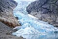
Image gallery
Briksdal Glacier, Norway.

Akkem glacier in the Altái massif, Russia.

Sorata Glacier, Bolivia.

Ossoue Glacier, in the French Pyrenees.

Glacier at Chugach State Park, Alaska, United States.

Glacier Davidson, Haines, Alaska.

Detail of glacier Davidson, Haines, Alaska.
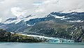
Glacier Johns Hopkins, Glacier Bay National Park, Alaska, United States.
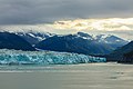
Hubbard Glacier, Alaska, United States.
.jpg)


Complementary bibliography
- DERRUAU, Max. «The glacial erosion system.» In Geomorphology. Section 3, chapter 2. Barcelona: Ariel, 2nd ed., 1991.
- KASER, Georg; OSMASTON, Henry. Tropical Glaciers. Cambridge University Press, 2001. ISBN 0-521-633-8.
- HAMBREY, Michael; ALEAN, Jürg. Glaciers. Cambridge University Press, 2004. ISBN 0-521-82808-2.
- MATTERN, Joanne. Antarctica: The largest glacier in the world. The Rosen Publishing Group, 2004. ISBN 0-8239-6874-X.
- STRAHLER, Arthur N. “Landforms made by glaciers”. In Physical Geographychapter 26. New York: John Wiley and Sons, 1960.
- STRAHLER, Arthur N. (1992, reprint 1997) Physical Geology, chap. 18: Pleistocene Glaciers and Glaciers, Barcelona: Ed. Omega ISBN 84-282-0770-4.
- Tarbuck, E., 1999, Earth Sciences: An Introduction to Physical Geology, Madrid, Prentice Hall.
Contenido relacionado
Guatemala city
Annex: Municipalities of the province of Burgos
Peaks of europe