Ghanaian Geography
Ghana, open to the Gulf of Guinea, lies in the center of the west coast of Africa. It extends over an area of 238,540 km² between Cape Tres Puntos, to 4.o 30&# 39; North latitude and the 11th parallel.o N. It limits to the north with Burkina Faso, to the east with Togo and to the west with the Ivory Coast. The main geographical feature of Ghana is Lake Volta, located in the east of the country, near the border with Togo. Precisely, from this country you can see the lake in some regions. It should also be noted that in the center is the Ashanti country, which is one of the most characteristic regions of Ghana and one of its best-known ethnic groups.
Relief and biogeography
Most of the country is made up of low-lying plains, made up of deeply eroded Precambrian rocks that bring half of Ghana to below 152m elevation.
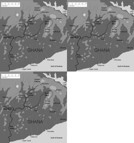
The 537 km of coastline are lined with sand and numerous watercourses that are only navigable by canoe. The northern half of the country is dominated by the Volta River Basin, which flows to the southeast and occupies 45 percent of Ghana's total land area. It is bounded on the east by the Togolese Mountains, which stretch from the river delta to the middle of the country following the border with Ghana. Its maximum altitude is Mount Djebobo, 876 m. To the west, the Volta Basin is bounded and flanked by a series of hills and plateaus, including the Kwahu Plateau, which run northwestward forming a kind of funnel, at the end of which, about 80 km from the coast, the Akosombo dam was built in the 1960s, resulting in an immense reservoir known as Volta Lake, which occupies 8,500 km² and extends to the north through the Oti River valley and to the northwest through the valleys of the White Volta and the Black Volta.
The region between the Ivory Coast's Volta River Basin and the sea forms a wide triangle dotted with jungle hills and rivers. This region, known as Ashanti, produces cocoa, minerals and timber. One of its rivers, the Birim, a tributary of the Pra, has given its name to a geological era, the Birrimian, and to a type of rocks that occupy the immense Proterozoic base that It extends through the Ivory Coast, Guinea, Mali and Burkina Faso, and that in this area it is rich in diamonds.
The landscape, in the Volta river basin, rises progressively to 400 m in altitude, and is covered with low scrub, savannah and herbaceous plains on the borders with Burkina Faso and northern Togo and the Ivory Coast. Here there are trees such as baobab, shea and acacias. In the wetter southern zone, there are deciduous and evergreen forests in which mahogany, iroko, ebony, and guinea oil palms grow. On the coast there are mangroves.
Climate
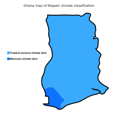
Ghana's climate is tropical monsoonal, with a dry season in winter and a rainy season in summer due to the African monsoons. In this context, five regions can be distinguished: the dry north of the country, with rains from May to September; the center-north, from April to October; and the south, from April to November. In the southeast, at the mouth of the Volta River, it rains between April and June and in September and October, with a break in July and August. In contrast, in the far west, from the border with the Ivory Coast to Cape Tres Puntas, the longest rains reach 2,000 mm.
In the center and north, temperatures before the rainy season can reach the 40s.oC easily, with means of 38.orC and 39.oC in March and April, especially when the harmattan blows from the Sahara desert. In the most desert areas, between February and April, temperatures can drop to 10.o c. In Tamalé, in the center-north, 1,054 mm fall, in 77 days between March and October.
In the south, in the Ashanti region, the rainiest month is June. In Kumasi, 1,465 mm falls in 120 days, with 225 mm in June, but although it rains mainly between March and October, it does not stop raining in any month. The average maximum temperatures do not exceed 32.oC and the minimum does not drop below 20.oC.
In the coastal area of Accra, in the southeast, 790 mm falls in 58 days, with a maximum in May and June, and almost nothing in August and December and January. At the other end of the coast, in Axim, 1,910 mm falls in 157 days, with a maximum of 480 mm in June, but rains occur throughout the year.
The sea temperature oscillates between 25.oC in September and 29. oC April and May in the Accra area.
Hydrography
Despite not being an excessively rainy country, Ghana is drained by numerous rivers. There are also numerous coastal lagoons, as well as the huge 8,500 km² artificial Lake Volta, formed by the Akosombo Dam, and the 10 km-diameter Lake Bosumtwi, formed by a meteorite, 30 km from Kumasi, the Ashanti capital..
The Kwahu plateau, which separates the Volta basin, is the origin of several rivers that flow towards the Atlantic, especially the Pra, with its tributaries, Ofin, Anum and Birim. Further west, in the foothills and uplands of the Ashanti Plateau, the sources of the Ankobra River (190 km), the Tano River (400 km) and the Bia River (160 km) flow into the Ivory Coast. To the east The Densu and Ayensu rivers originate from the small Atewa mountain range, which closes off the final stretch of the Volta river to the west.
The presence of gold in the basins of these rivers led the country to be called the Gold Coast before its independence.
The Volta River Basin occupies, in Ghana, 158,000 km² of the 388,000 km² it occupies as a whole. The basin is bounded to the south by the Kwahu Plateau, to the west by the Konkori Escarpment (480 m, in Mole National Park) and to the north by the Gambaga Escarpment, 300 to 460 m. The Volta riverbed above the reservoir ranges between 150 and 215 m above sea level, while the lake is at 75-80 m above sea level. The floor of the basin is sandstone, the rainfall ranges between 1,000 and 1,140 mm, very centered in summer, giving rise to a savannah landscape, with localized forests that depend on the richness of the terrain.
With the exception of the Todzie River (267 km), which meets near the mouth, the others flow into the vast Lake Volta basin: the Afram River (100 km), coming from the Kwahu Plateau to the west; the Oti River (520 km) forms the border with Togo before joining Lake Volta to the east; The Atacora, Sene, Daka and Pru rivers flow into the lake, as well as the Black Volta, to the west, which receives the Tain River, and the White Volta, to the north, which receives the Kulpawn and Red Volta rivers.
Main cities
The following shows the main cities with population registered in the census in September 2010 or in March 2000 (in this second case an asterisk * appears), and the code of the region to which they belong:
- Acra 2,070,463
- Adenta East ACC 31,070*
- Aflao VOL 38,927*
- Augment ASH 28,271*
- Agona Swedru CEN 54,417
- Ahwia ASH 19,729*
- Akatsi VOL 19.617*
- Akim Oda EAS 51,231
- Akwatia EAS 20,723*
- Amanfrom ACC 119,467
- Anloga VOL 20,886*
- Asamankese EAS 46,061
- Ashaiman ACC 190,972
- Assin Fosu CEN 22,837*
- Atebubu BAH 20,022*
- Awoshie ACC 19,890*
- Axim WES 21,768*
- Bawku UEA 61,151
- Bekwai ASH 19,679*
- Berekum BAH 56,414
- Bibiani WES 22,381*
- Bimbilla NOR 21,016*
- Bolgatanga UEA 65,549
- Buduburam CEN 50,560
- Cape Coast CEN 169,894
- Dome ACC 29.618*
- Dormaa Ahenkro BAH 22,913*
- Dunkwa-on-Offin CEN 26,215*
- Dzodze VOL 18,957*
- Effiduase ASH 18,700*
- Ejura ASH 29,478*
- Elmina CEN 21,103*
- Gbawe ACC 69,356
- Ho VOL 104,532
- Hohoe VOL 73,641
- Kade EAS 18.545*
- Kintampo BAH 42,957
- Koforidua EAS 120,971
- Konongo ASH 26,735*
- Kumasi 2,035,064
- Lashibi ACC 30,193*
- Madina ACC 79,832
- Mampong ASH 31,740*
- Mandela ACC 61,880
- Mankessim CEN 25,481*
- Mim BAH 22,212*
- New Achimota ACC 22,767*
- New Tafo EAS 18.635*
- Nkawkaw EAS 47,968
- Nkoranza BAH 21,715*
- Nsawam EAS 29,986*
- Nsuatre BAH 18,931*
- Obuasi ASH 143,644
- Oduponkpehe CEN 69,384
- Prestea WES 21,844*
- Sakumono ACC 20,172*
- Savelugu NOR 24,937*
- Sekondi WES 228,342
- Suhum EAS 31,044*
- Sunyani BAH 74,240
- Taifa ACC 26.145*
- Takoradi 311,206
- Tamale NOR 371,351
- Tarkwa WES 30.631*
- Techiman BAH 67,.241
- Item ACC 139,784
- Item New Town ACC 58,786*
- Wa UWE 71,051
- Wenchi BAH 28,141*
- Winneba CEN 57,015
- Yeji BAH 18,593*
- Yendi NOR 51.727
Protected Areas of Ghana
In Ghana there are 321 protected areas, about 36,153 km², 15.05% of the territory, and 221 km² of marine areas, 0.1% of the 226,759 km² that belong to the country. Of these, 7 are national parks, 294 are forest reserves, 4 are nature sanctuaries, 1 is a strict reserve, 1 is a resource reserve, and 5 are game reserves. Three are Unesco biosphere reserves and 6 are Ramsar sites. In 2010, the IUCN recognized eight effectively protected parks and reserves, covering 7,888 km², 3.3% of the territory.
- Conservation area Ankasa, 509 km2. It comprises the National Park of Nini-Suhien, 166 km2 and the Ankasa Hunting Reserve, 343 km2. Wet forest.
- Conservation area Bia, 306 km2. is formed by Bia National Park, 77.7 km2, north and Bia Resource Reserve, 228 km2, south. Between perennial and deciduous forest.
- Sanctuary of the nature of Bomfobiri, 53 km2, savannah.
- Bui National Park, 1,813 km2, savannah.
- Kakum National Park, 360 km2. Wet forest.
- Kyabobo National Park, 220 km2, mountain savannah.
- Mole National Park, 4.577 km2, savannah.
- Shai mountain range resource reserve, 51 km2 (Shai Hills Resource Reserve), very close to the parks of Mole and Kakum. Sabana.
- Digya National Park, 3,743 km2, savannah.
- Kogyae strict natural reserve, 386 km2, savannah.
Population and ethnic groups of Ghana
In Ghana, there is an estimated population of 30,115,300 people in 2019, according to United Nations data. The average age is 20.5 years. 75% of the population is under 25 years of age. Fertility continues to be highest in northern areas and more moderate in urban areas. Life expectancy at birth is about 67.4 years (65 for men, 70 for women). The average fertility is estimated at 4 children per woman in 2018. Among the most important ethnic groups in 2010 were the Akan, almost half of the population (47.5%), the Dagomba (16.6%), the Ewé (13.9%), the Ga-dangme (Gameis and Adangme, 7.4%), the Gurma (5.7%), the Guan (3.7%), the Gurunsi (2.5%), the Mandinka (1.1%) and others (1.4%). In 1960 there were about a hundred language and cultural groups in Ghana.
Contenido relacionado
Fukaya (Saitama)
Annex: Municipalities of the province of Cáceres
Mali Geography


