Geography of the Federated States of Micronesia
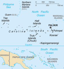
The Federated States of Micronesia is a sovereign state in the region of Micronesia, in the western Pacific Ocean, consisting of 607 islands stretching along the Caroline Islands archipelago (together with Palau), east of the Philippines. It is divided into four island groups: Yap, Chuuk (called Truk until January 1990), Pohnpei (called Ponape until November 1984), and Kosrae. The federal capital is Palikir, in Pohnpei. The country occupies 702 km² of land surface that extends for 2,700 km, from west to east, north of the equator and has an economic catchment area of 2,600,000 km² in the Pacific Ocean.
Geology
The Federated States of Micronesia are a group of 607 small islands, known as the Caroline Islands, comprising four main states: Yap, Chuuk or Truk, Pohnpei or Ponape, and Kosrae or Kusiae, stretching from west to east. The four islands of Yap, made up of continental crust, form an arc at the eastern convergence of the Philippine Plate, connected to the Palau island arc to the south and the Izu-Bonin-Mariana arc to the north. Tectonically, the Yap Arc is on the margin of the Carolina Plate, which is being subducted under the Philippine Plate.
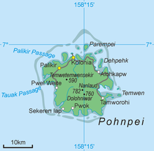
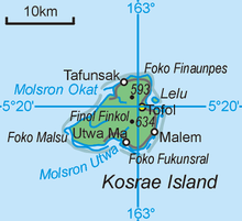
The geology of Micronesia is complex. It comprises six geologic subregions that range in age from 97 million years old in the Marshall Islands, home to the oldest coral atolls on earth, to the relatively young volcanic islands of the northern Marianas. Pohnpei (344 km² and 772 m elevation) and Kosrae (110 km², 634 m elevation) are volcanic islands surrounded by coral reefs. Yap's four are linked by an extensive coral reef supported by an uplift of the Philippine plate. Chuuk Lagoon is made up of 12 volcanic islands surrounded by a series of 24 coral islets that form a barrier reef.
Collectively, the varied geology includes volcanic islands, coral reefs, atolls, very flat, low-lying islets, and calcareous islands.
Biodiversity
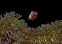
The largest coastal communities are mangrove forests, seagrass beds, lagoons, and coral reefs, biologically and physically linked. In Micronesia there are recognized about 300 species of coral, 1000 species of fish and 1200 species of mollusks. In mangrove forests there are shrimp, crabs and fish, as well as birds that feed on them. Seagrass beds appear offshore after mangroves. The lagoons provide food for the reef inhabitants and contain various kinds of plankton. The biodiversity and complexity of coral reefs increases markedly from east to west, with 150 hard coral species in Kosrae, 200 in Pohnpei and 300 in Chuuk. The productivity of corals in this area is one of the highest in the world, absorbing about 2,500 grams of carbon per square meter per year, compared to 2,200 grams in the tropical forest and 125 grams in the open sea.
Inland, from the tidal zone to the tops of the mountains there is a varied range of vegetation, cloud forest, upland, palm, plantation, areas dominated by climbers of the genus Merremia, savannahs, native secondary forest, introduced tree fragments, cultivated areas, freshwater swamps, Nypa fruticans palm swamps, atoll forests, rocky forests and beaches. There are some 1,230 species of ferns and flowering plants, of which 782 are native, including 145 native fern species. On the island of Pohnpei, there are about 750 plant species, of which 110 are endemic. Another 457 species have been introduced.
The only mammals native to the islands are five species and subspecies of bats of the genus Pteropus and one embalonurid. Further, three types of rats have been introduced, the Polynesian rat, the black or common rat and the brown rat. There are also mice, dogs, cats, goats, a few cows, and in Pohnpei, the Philippine sambar cervid.
According to BirdLife International, there are 127 bird species in Micronesia, of which 21 are endemic and 12 are globally threatened: Carolinian partridge pigeon, Furthermore petrel, White-necked Shearwater, Pacific Curlew, Siberian Curlew, Great Knot, Todiramphus reichenbachii (Pohnpei Kingfisher), Yap Caterpillar, Pohnpei Caterpillar, Truk Monarch , white-eyes of the Truk and Ponapé starling. On the islands there are also 15 IBAs, areas of importance for birds.
Climate
The climate of the Federated States of Micronesia is equatorial, hot, humid and rainy all year round. The islands are north of the equator and are affected by constant trade winds, which temper the climate. The minimum temperatures oscillate throughout the year between 22 and 25.oC, and the maximum between 30 and 32.orC. The abundant rainfall ranges between 2,500 and 5,000 mm per year, although on the faces facing the wind they can exceed 6,000 mm. Mount Nahnalaud, only 750 m high, on the island of Pohnpei, receives an average of 10,160 mm, making it one of the rainiest places on earth, with almost always cloudy skies. In general, the rains are produced by means of showers and storms of short duration but very intense. The driest places are the flat atolls, where rainfall can drop below 3,000 mm. The driest months are January and February, without going below 250 mm and 20 days with rain.
In Palikir, the capital, on the island of Pohnpei, 7.oN, about 4750 mm fall annually, with a minimum of 300 mm in January and a maximum of 490 mm in May. The average is 20 days with monthly rain and an average of 400 mm. The temperatures, with very little variation, with a daily oscillation of 22 to 31.oC. Sea water stays year-round at 29.oC.
On the drier island of Yap, at 9.oN, they fall slightly more of 3000 mm, with a minimum between February and April of about 150 mm and only 13-14 days of rain, and a maximum of 385 mm in August. In Chuuk, further east, something similar happens, but with a little more rain, just over 3,500 mm per year, a minimum of 205 mm in February and a maximum of 360 mm in August and September, with 25 rainy days. In both it is a little hotter than in Pohnpei, since the lows do not drop below 24-25.o C.
Typhoons can occur between April and December, although they are more frequent between August and November.
Protected areas
In Micronesia there are 5 protected areas, 0.05% of the land surface, and 475 km² of marine areas, 0.02% of the total 3,011,917 km² that belong to the country. There are 2 sanctuaries, 1 marine conservation area and 2 Unesco biosphere reserves.
Unesco Biosphere Reserves
- Atolón And, 950 ha, 18.5 km southwest of Pohnpei. Representative of the Micronesian atolls, with a lagoon of 74 km2, houses 25 species of birds and 13 species of reptiles, green turtle and turtle carey.
- Utwe, 17.73 km2. Small volcanic island southwest of Kosrae. It has a narrow plain coastal strip and the rest are wild hills. It is surrounded by mangroves and coral reefs, with 335 fish species and 180 coral, 13 soft and 150 hard.
Shrines
- Nahmwen Na Stingray, 233 ha, east of Pohnpei. Created to protect a significant area of habitat of various stripes of order Myliobatiformes in the waters of Pohnpei.
- Marine Sanctuary of Oroluk, 469 km2. Created to preserve the coral reefs of the Oroluk atoll, all areas of the lagoon (420 km2) from the tide area to a depth of 600 m. The atoll consists of 25 islets and sand banks devastated by the annual cyclones, of which only one forest islet remains, called Oroluk Island.
Marine Conservation Area
- Rumung, 2,86 km2. Also known as forbidden island.
General data
Location: In Oceania, it represents a group of islands in the northern Pacific Ocean, about two-thirds of the way between Hawaii and Indonesia.
Geographic coordinates: 6º55' north latitude, 158º15' east longitude.
Area (Pohnpei (Ponape), Chuuk (Truk) Islands, Yap and Kosrae Islands):
- Total: 702 km2
- Floor: 702 km2
- Water: 0 km2
Coastal length: 6,112 km
Climate: tropical. Heavy rains throughout the year, especially in the eastern islands. Located at the limit of the typhoon area, being occasionally seriously affected.
Terrain: geological diversity ranging from high mountain ranges to low-lying coral atolls; volcanism in Pohnpei, Kosrae and Chuuk.
Highest point. Totolom 791 m
Natural resources: forests, marine products, minerals from the seabed.
Natural risks: Typhoons (June to December).
Contenido relacionado
Rio Grande do Sul
Monforte de la sierra
Ferrol


