Geography of Russia
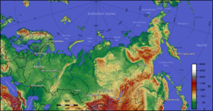
Russia (Russian: Россия, transliterated: Rossíya) is the largest country in the world and stretches across almost the entire north of the supercontinent of Eurasia: it occupies the Northern Asia (1/3 of the continental total) and Eastern Europe –respectively, 74.7% and 25.3% of its territory. It is separated from the American continent by the Bering Strait.
Due to its size, Russia displays both monotony and diversity, and like its geography, its climate, vegetation, and soils span great distances. Running north to south of the East European Plain, there is a sequence of tundra, coniferous forests (taiga), mixed deciduous forests, grasslands (steppe), and semi-desert (the Caspian Sea fringe), with changes in vegetation reflecting major changes in climate. Siberia has a similar sequence, although the taiga is predominant.
The country has 40 Biosphere Reserves declared by UNESCO and eight natural areas have also been declared World Heritage Sites.
Physical geography
General framework and borders
Located in the northern and mid-latitudes of the Northern Hemisphere, most of the Russian Federation is much closer to the North Pole than it is to the equator. In a country comparisons are of little value, but not in Russia with its enormous size and diversity. At 17.1 million km², it comprises one eighth of the Earth's inhabited area and slightly less than twice the size of the United States. Its European part, comprising a substantial part of continental Europe, is home to most of Russia's industrial and agricultural activities and it was here, roughly between the Dnieper River and the Ural Mountains, that the Russian Empire took shape..
Russia impresses with its dimensions in any aspect. From west to east, the country stretches from Kaliningrad (an enclave cut off from the rest of the country by Lithuania's 1991 secession from the then-Soviet Union) to Ratmanov Island (one of the Diomede Islands) in the Bering Strait. This distance is equivalent to more than 9200 km. Running north to south, the country stretches from the northern tip of the Arctic islands of Franz Joseph Land to the southern tip of the Republic of Dagestan in the Caspian Sea, around 4,500 km of highly varied, and often inhospitable, terrain.
The border of the Russian Federation is the longest in the world, and is a major source of national security concern in the post-Soviet period. Along its 20,139-kilometre land border, Russia borders fourteen countries, eight of which did not exist as countries until the early 1990s. Furthermore, at its northeastern tip, only fifty-six kilometers from the Bering Strait they separate mainland Russia from its 15th neighbor, the United States — although the closest border between the two countries is the 3.8 kilometers that separate the island of Greater Diomede (Russia) from Lesser Diomede (USA). In addition, it has borders with the partially recognized republics of Abkhazia and South Ossetia.
Extreme Points (Russian)
Russian extreme points Feature Location Denomination Coordinates Northerner point Total Cabo Fligely (Earth of Francisco José) 81°50′35′N 59°14′22′′E / 81.84306, 59.23944 Continental Cape Cheliuskin (Krai of Krasnoyarsk) 77°44′N 104°15′E / 77.733, 104.250 More southern Total and continental Monte Bazardyuzyu (Dagestan) 41°13′14′N 47°51′28′′E / 41.22056, 47.85778 More Eastern Total Grand Diomedes Island (Chukotka) 65°47′N 169°01′O / 65.783, -169.017 Continental Cape Dezhnev (Chukotka) 169°40'O More Western Total Narmeln, Cord of the Vistula, (Oblast of Kalingrad) (19°38'E) Continental Lavry (Pskov Oblast) 27°19'E Northerner city Pevek (Chukotka) 69°42′N Southernmost city Derbent (Dagestan) 42°04′N 48°17′E / 42.067, 48.283 Eastern City Anádyr (Chukotka) 64°44′N 177°30′E / 64.733, 177.500 Western City Baltiysk (Kalinning Oblast) 19°55′E Northerner settlement Dikson 73°30′N 80°32′E / 73.500, 80.533 More southern settlement Kurush, Dagestan 41°16′N More eastern settlement Uelen, (Chukotka) 169°48′O Westerner settlement Baltiysk (Kalinning Oblast) 19°55′E Highest point Monte Elbrús 5,642 m Less high Caspian Sea −28 m (*) Total includes all Russian islands and archipelagos and the Kaliningrad exclave.
Geographic Regions
The territory of the Russian Federation has traditionally been divided, for geographical purposes, into the following six major regions:
- Russia or European Russia, the European part to the Ural Mountains. It is divided into four subregions:
- Central region (approximately 650 000 km2), the region around Moscow, the main industrial region of Russia.
- The "black lands", (approximately 600 090 km2), the southern part around the republics of the Caucasus or Ciscaucasia
- the Leningrad region (approximately 1 600 000 km2), the northwest part, the area of the provinces that open to the Battic and the sea of Kara.
- Volga countries (approximately 1 000 km2), located in the southwest
- the Urals, the region of the Ural Mountains.
- Western Siberia (2 427 000 km)2), immediately east of the Ural Mountains, to the river Yeniséi, it is a vast plain of 2000 km wide, of low and poorly drained land, where the swamps, lakes and swamps are very common; the north coast end of the Arctic Ocean very little illuminated by the sunlight has a bioma of tundra, immediately south of the tundra begins a N begins the presence of a dense foresta de latifolias caducifolias forming the taiga of Western Siberia. Geographically, the main unit is the Western Siberia plain.
- Central Siberia (4 122 000 km2), between the Yeniséi and Lena rivers, which culminates between 300 and 1200 m of altitude, surrounded by cannons or deep lakes such as Lake Baikal. In the south, there is a high mountainous system formed by the Altái mountain range and the Sayanes mountains with peaks of 3-4000 m. The main unit is the Siberia Central Plateau.
- East Siberia or the Russian Far East (more than 6 million km2), the territories east of the Lena River and south of the Amur River, which open to the Pacific coast, is constituted by several mountainous massifs that end east in the Bering Strait and the Kamchatka peninsula where active volcanoes abound.
- The Arctic.
These geographical divisions have served as the basis for the division into federal districts of Russia carried out in the year 2000, although the Arctic region has been ignored (including it in the four federal districts with coasts) and the limits have not been respected. strictly geographical: thus, the Ural district incorporates a part of Western Siberia, while the other part is added to the federal district of Siberia (which corresponds to the geographical region of Central Siberia).
Eastern European Plain
The East European Plain encompasses most of European Russia. The West Siberian Plain, which is the largest in the world, stretches east from the Ural Mountains to the Yenisei River. Because the terrain and vegetation are relatively uniform in each of the natural areas, Russia presents an illusion of uniformity. However, the Russian territory has representation of all the main vegetation zones of the world, with the exception of the tropical forest.
Ural Mountains
The Ural Mountains are the best-known mountain range in the country, because they form the natural border between Europe and Asia. The ridge stretches for about 2,500 km, from the northern border of Kazakhstan to the Arctic Ocean (Vaigach Island and the islands of Novaya Zemlya are part of the ridge). 68% of the Ural Mountains are in Russia, while the remaining 32% are in Kazakhstan. In terms of elevation, the Urals are far from being an impressive mountain range and do not constitute an insurmountable natural barrier, with several low passes that cross them and through which the main transportation routes run. The highest peak, Mount Naródnaya, is only 1,895 m.
Although not impressive from a scenic point of view, the Urals contain valuable mineral deposits of iron, coal, and oil, as well as nickel, gold, silver, and gems such as topaz and beryllium, making the region a major industrial center of Russia, being the main cities Yekaterinburg, Chelyabinsk, Magnitogorsk, Ufa and Perm.
Geographers have traditionally divided the Ural Mountains into five regions: South, East, North, Subarctic, and Arctic. The wooded line falls from 1400 m to sea level, as it advances in a northerly direction. The southern and central sections are completely covered with forest. The virgin Komi forests have been declared a World Heritage Site in 1995.
West Siberian Plain
To the east of the Urals is the West Siberian Plain, which occupies an area of 2.6–2.7 million square kilometers (one third of Siberia). It extends, in a north-south direction, 2,400 km, from the Arctic Ocean to the Altai Mountains, the Sayan Mountains and the Baikal Mountains; and, in an east-west direction, 1,900 km, from the Yenisei River to the Urals. This plain has been described as the largest unbroken expanse of lowland in the world—more than 50% is less than 100 m above sea level.
The main rivers of the West Siberian Plain are the Ob, Irtysh, and Yenisei. Due to the snowmelt in spring, the rivers overflow, flooding large nearby areas, leaving large lakes and swamps. It is one of the largest swamps in the world (the largest single swamp in the world is believed to be Vasugánskoe, with an area of 51,600 km²), making the region highly unsuitable for agriculture.
Most of the region's population lives in the dry section, south of parallel 55° N. The region's main cities are Surgut and Nizhnevartovsk. Winters in the West Siberian Plain are harsh and long, with a subarctic or continental climate.
The plain has eight regions with different vegetation: tundra, forest-tundra, northern taiga, middle taiga, southern taiga, sub-taiga forest, forest-steppe, and steppe. The number of animal species in the West Siberian Plain ranges from about 107 in the tundra to 278 or more in the forest-steppe region.
There are large reserves of oil and natural gas. Most of the oil and gas production was extracted from this area during the 1970s and 1980s.
Central Siberian Plateau
The region immediately to the east of the West Siberian Plain is the Central Siberian Plateau, which stretches from the Yenisei River to the Lena River. It consists of a set of low plateaus, between 320 and 740 m, the highest part of which is the Putorana plateau, which reaches 1,700 m.
The immense region, an extension of more than 3.5 million km², is limited, to the north, by the North Siberian Plain in which the Taimyr swampy plain is located (to the south of the Taimyr Peninsula); to the south, by the different mountainous massifs of southern Siberia, such as the Sayanes mountains and Baikal mountains that border Lake Baikal; to the west, by the Yenisei River; to the east, the Lena River.
The climate is continental, with short, warm summers and long, very cold winters. Although endowed with considerable mineral wealth, like much of Siberia, it has remained largely uninhabited until now, with some major cities located on the banks of the great rivers at the edges of the region.
Most of the territory is covered by coniferous forests. The most important rivers of the plateau, some tributaries of the Yenisei and Lena, are the Lower Tunguska, Stony Tunguska, Angara River, Viliui River and Olenyok River.
Sayan and Stanovoy Mountains
In the mountain system west of Lake Baikal, in south-central Siberia, the highest elevations are 3,300 m in the western Sayan Mountains, 3,200 m in the eastern Sayan Mountains, and 4,506 m m from Mount Belukha in the Altai massif. The eastern Sayan region reaches almost to the southern shore of Lake Baikal; At the lake, there is an elevation difference of more than 4,500 m between the nearest mountain, 2,840 m high, and the deepest part of the lake, which is 1,700 m below sea level. The mountain systems east of Lake Baikal are lower, forming a complex of minor ridges and valleys running from the lake to the Pacific coast. The maximum height occurs in the Stanovoy Mountains (Mount Skalisty, 2482 m), which extends from west to east, from the north of Lake Baikal to the Sea of Okhotsk. To the south of this range is southeastern Siberia, whose mountains reach 800 m. Across the Strait of Tartary is the island of Sakhalin, whose highest elevation is Mount Lopatin (1,609 m).
Caucasus Mountains
Truly alpine terrain appears in the southern Caucasus mountain ranges, between the Black Sea and the Caspian Sea, the natural border between Europe and Asia, with impressive heights, a great geographical barrier, almost impassable, with few steps between Russia and its southwestern neighbors Georgia and Azerbaijan. It is a large mountain range located between the basins of the Kuban River and the Terek River in northern Anatolia, and the Iran River in the south. It is made up of two separate mountain systems:
- the Great Caucasus (in Russian) Bolshói Kavkaz), or simply Caucasus, is a large rectilinear cordillera of 1200 km long, oriented from northwest to southeast, from the Natural Reserve of the Caucasus, in the Black Sea, to and the peninsula of Apsheronsk, almost in Baku, in the Caspian Sea.
- the Caucasus Minor (in Russian) Maly Kavkaz), which runs parallel to the south of the previous one, about 100 km of average distance, of more complex structure and extending about 1,125 km across the mountains of southern Georgia and Armenia, being of volcanic origin.
Many of the peaks in the Russian Caucasus exceed 4,500 m, the highest being Mount Elbrus in the Greater Caucasus, which at 5,642 m is the highest point in Europe.
The region has an alpine-type climate and has considerable hydraulic resources such as the Kurá River and valuable oil and natural gas reserves.
Northeast Siberia and Kamchatka
Northeast Siberia, north of the Stanovoy ridge, is a very mountainous region. The long Kamchatka peninsula, which reaches south to the Sea of Okhotsk, includes many volcanic peaks, some of which are still active. The highest is Klyuchevskoi (4,750 m), the highest point in the Russian Far East. The volcanic chain continues from the southern tip of Kamchatka south through the Kuril Islands and into the Japan chain. Kamchatka is also one of the two centers of seismic activity in the Russian Federation (the other being the Caucasus). In 1995, a major earthquake destroyed much of the oil-refining city of Neftegorsk. Also found in this region is the large Beyenchime-Salaatin crater.
Russian Mountain Ranges
Russian mountain ranges are found mainly along its continental divide (the Ural Mountains). Along the southwestern border (the Caucasus), along the border with Mongolia (the eastern and western part of the Sayan Mountains, and the western end of the Altai Mountains), and in the eastern part of Siberia (a complex system of mountain ranges in the northeast corner of the country that form the backbone of the Kamchatka Peninsula, and, to a lesser extent, the mountains along the Sea of Okhotsk and the Sea of Japan). Russia has nine major mountain ranges. In general, the eastern half of the country is much more mountainous than the western half, the interior of which is dominated by low plains. The traditional dividing line between east and west is the Yenisei River valley. Delineating the western border of the Central Siberian Plateau from the West Siberian Plain, the Yenisei extends from near the Mongolian border north into the Arctic Ocean, west of the Taymyr Peninsula.
Hydrography
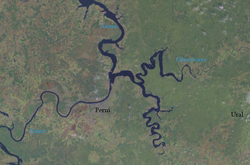
Russia is a country rich in water. The first settlements in the country arose along the rivers, where the majority of the urban population still lives. The Volga, the longest river in Europe, is by far the most important commercial waterway in Russia. Four of the country's thirteen largest cities are located on its shores: Nizhny Novgorod, Samara, Kazan and Volgograd. The Kama River, which flows west from the southern Urals to join the Volga in the Republic of Tatarstan, is the second most densely populated European river system on its banks.
Rivers of Russia
Russia has thousands of rivers and inland bodies of water, endowing it with one of the largest water resources in the world. However, most of Russia's rivers and streams belong to the Arctic watershed, which is located mainly in Siberia but also includes a European part of Russia. In total, 84% of Russia's water surface is located east of the Urals, in rivers that flow through sparsely populated territory and empty into the Arctic and Pacific oceans. In contrast, areas with the highest concentration of population, and therefore the highest demand for water supply, tend to have the hottest climates and the highest evaporation rates. As a result, densely populated areas such as the Don River and Kuban River basins in the North Caucasus have barely adequate (and in some cases insufficient) water resources.
Forty of Russia's rivers longer than 1,000 km lie east of the Urals, including the three main rivers that drain Siberia and flow north to the Arctic Ocean: the Irtysh-Ob system (totaling 5,380 km), the Yenisei River (4,000 km), and the Lena River (3,630 km). The basins of these river systems cover about eight million square kilometers, discharging about 50,000 m³/s of water into the Arctic Ocean. Since these rivers flow northward it means that the source areas thaw before the downstream areas, creating huge swamps, such as the Vasiugan swamps in the center of the West Siberian Plain (53,000 km²). The same is true of other river systems, including the Pechora and Northern Dviná rivers in Europe and the Kolymá and Indiguirka rivers in Siberia. Approximately 10% of the Russian territory is classified as swampy.
Many other rivers drain Siberia from the eastern ridges into the Pacific Ocean. The Amur River and its main tributary, the Ussuri River, form a long stretch of the border between Russia and China. The Amur system drains most of southeastern Siberia. Three basins drain European Russia: the Dnieper River, which flows mainly through Belarus and Ukraine, and has its headwaters in the hills west of Moscow; the Don river, with 1860 km, originates from the Russian Central Plateau, south of Moscow, and then flows into the Azov Sea and the Black Sea in Rostov-on-Don; and the third, the Volga River, by far the largest of the European systems, which rises in the Valdai Hills west of Moscow and meanders southeast for 3,510 km before emptying into the Caspian Sea. In total, the Volga system drains a basin of about 1.4 million square kilometers. Linked by several canals, Russia's long European rivers have been a vital transportation system, and the Volga system still carries two-thirds of Russia's river traffic.
The main rivers of European Russia are the following:
- courses entirely Russian: Volga, Don, Kama, Oká and the Northern Dviná,
- Partly Russian courses: Dniéper and the Western Dvina.
The main rivers of Asiatic Russia are the following:
- Obi, Irtysh, Yeniséi, Angara, Lena, Amur, Yana, Indiguirka and Kolymá.
Lakes and reservoirs
Russia's inland bodies of water are essentially an extensive legacy of glaciation. In European Russia, the largest lakes are Lake Ladoga (17,700 km²) and Lake Onega (8,984 km²), north-east of Saint Petersburg, Lake Peipus (3,555 km²) on the Estonian border, and the Ribinsk Reservoir north of Moscow. Smaller, man-made reservoirs, 100 to 200 miles long, are found in the Don, Kama, and Volga basin rivers. Large dams have also been built on Siberian rivers, such as the Bratsk Reservoir, northwest of Lake Baikal, which is one of the largest in the world.
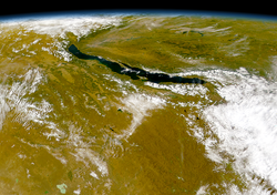
The largest of Russia's freshwater bodies is Lake Baikal, with a water surface of 31,494 km², which is the deepest and largest freshwater capacity in the world. Lake Baikal alone holds 85% of the freshwater resources of Russian lakes and 20% of the world total. It stretches 632 kilometers in length and 59 km across at its widest point. Its maximum depth is 1713 m. Many other smaller lakes dot the northern plains of the European and Siberian regions, the largest being Lake Vygozero (1,250 km²), Lake Beloye (1,125 km²), Lake Topozero (986 km²) and Lake Ilmen (982 km²), in northwestern Europe; and Lake Chany (2000 km²) in southwestern Siberia.
Seas
Approximately 2/3 of its borders are bounded by water. Virtually the entire long northern coastline is well above the Arctic Circle and, with the exception of the port of Murmansk - which receives currents that are somewhat warmer than would be expected from its latitude, due to the effects of the Gulf Stream. - This coast is blocked by ice most of the year. Thirteen seas - south, Azov, Caspian and Black; to the north, White, Barents, Pechora, Kara, Laptev, East Siberian and Chukchi; and to the east, Bering, Okhotsk and Japan - and direct parts of three oceans - Arctic, Atlantic and Pacific - wash the Russian shores.
Islands
Climate
Russia has a completely continental climate, due to its compact size and configuration. Most of its territory is more than 400 km from the sea, and its center 3840 km from the coast. In addition, the mountain ranges to the south and east block the moderate temperatures of the Indian Ocean and Pacific Ocean, although European Russia and northern Siberia lack such geographical protection from the Arctic and North Atlantic.
Because only small parts of Russia are south of 50°N and more than half of the country is north of 60°N, large regions are covered under snow six months of the year, with seasonally frozen and permanently frozen permafrost subsoil to depths of several hundred meters. The average annual temperature for most of European Russia is below freezing, and the average for most of Siberia is 0 °C or below. Most of Russia has only two seasons, a summer and a winter, with a very short season in between. Transportation routes, including all rail lines, are rerouted in winter to traverse frozen waters on rivers and lakes. There are, however, some areas that are important exceptions to this description: the moderate maritime climate of Kaliningrad Oblast, on the Baltic Sea, is similar to that of the Pacific Northwest; the Far East of Russia, under the influence of the Pacific Ocean, has a monsoon climate that reverses the direction of the wind in summer and winter, sharply differentiating temperatures; and a narrow territorial band in the Black Sea area has a subtropical climate, making it the most popular summer destination.
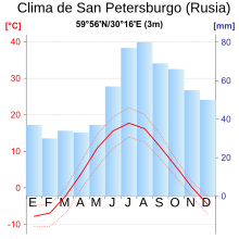
Russia is the coldest country in the world, with an average annual temperature of -5.5°C. In winter, an intense high pressure system is the cause of the winds blowing from the south and southwest throughout the Russian territory, except in the Pacific region; in summer, a low pressure system brings winds from the north and northwest to most of the country. This meteorological combination reduces the temperature difference between the north and the south during the winter. Thus, the average January temperatures are -8 °C in Saint Petersburg, -27 °C in the West Siberian Plain, and -43 °C in Yakutsk (in eastern central Siberia, at approximately the same latitude than St. Petersburg), while the winter average on the Mongolian border, whose latitude is about 10° further south, is hardly warmer. However, summer temperatures are more affected by latitude, with the average for the Arctic islands being 4 °C, and the average for the southern regions being 20 °C. The range of extreme temperatures is established between the national record low temperatures of -70 °C, registered in Verkhoyansk in north-central Siberia, and the record of 42 °C, registered in several stations in the south.
The long, cold winter has a profound impact on almost all aspects of life in Russia: it affects where and how people live and work, and the type of crops and where they are grown (no part of the country has a season annual growth). The length and severity of winter, together with the sharp fluctuations in the average summer and winter temperatures, impose special requirements on many branches of the economy: in permafrost regions, buildings must be built on stilts; the machinery must be made of special steels; and transportation systems must be designed to perform reliably in extremely cold and high temperatures. Furthermore, during long periods of darkness and cold, the demand for energy and health care increases.
Because Russia has little exposure to oceanic influences, most of the country receives low to moderate amounts of precipitation, with the highest rainfall in the northwest and decreasing amounts from northwest to southeast in European Russia. The wettest areas are the small, lush subtropical regions adjacent to the Caucasus region and the Pacific coast. Along the Baltic Sea coast, the average annual precipitation is 600 mm, and in Moscow it is 525 mm. An average of only 20 mm falls along the Russian-Kazakh border, and as little as 15 mm may fall in Siberia along the Arctic coast. The annual average number of snow days, a critical factor for agriculture, depends on both latitude and altitude, varying from 40 to 200 days in European Russia and from 120 to 250 days in Siberia.
Environment
Natural regions
Geographers have traditionally divided the vast territory of Russia into five regions or natural zones:
- the tundra area;
- the area of taiga or forest;
- the area of steppe or plains;
- the desert area
- the mountain area.
Most of the Russian Federation consists of two plains—the East European Plain and the West Siberian Plain—two lowlands—North Siberia and Kolyma in the extreme northeast of Siberia—two plateaus—the Central Siberian Plateau and the Lena Plateau to its east—and a series of mountainous areas, mainly concentrated in the far northeast or intermittently extending along the southern border.
Ecoregions
 | |||
Polar desertTundraTundra alpineTaiga | Mountain forestDeciduous temperate forestTempered stepDry step | ||
- Tundra
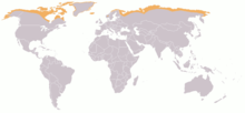
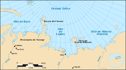
The Russian Arctic stretches for almost 7,000 km from west to east, from Karelia and the Kola Peninsula to Nenetsia, the Gulf of Ob, the Taymyr Peninsula, the Chukchi Peninsula (Kolyma, the Anadyr River region and as far as Corporal Dezhnev). The main islands and archipelagos in the Arctic Ocean are Novaya Zemlya, Severnaya Zemlya, and the New Siberian islands.
About 11% of Russia is tundra (a treeless swampy plain). The tundra is the northernmost part of the country, stretching from the Finnish border in the west to the Bering Strait in the east, and then south along the Pacific to the northern Kamchatka peninsula.
The area is known for its herds of wild reindeer, so-called white nights (dusk to midnight, dawn soon after) in summer, and days of total darkness in winter. The long, harsh winter and lack of sun allow only mosses, lichens, dwarf willows (Salix herbacea), and low shrubs to grow on the barren permafrost. Although several mighty Siberian rivers run through this area as they flow north to the Arctic Ocean, partial and intermittent snowmelt makes it difficult to drain the many tundra lakes, ponds, and swamps. Frost weathering is the most important physical process here, gradually shaping a landscape that was severely modified by glaciation in the last ice age.
Less than 1% of Russia's population lives in this area. The fishing and industrial ports of the northwestern Kola Peninsula and the large oil and natural gas fields of northwestern Siberia are the biggest employers on the tundra. With a population of 180,000, the border industrial city of Norilsk is the second most populous city, after Murmansk, among Russian settlements above the Arctic Circle.
- Taiga
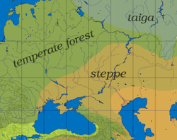
The taiga, which is the largest forest region in the world, contains mostly conifers, spruce, fir, pine, and larch. It is the largest natural area in Russia, an area the size of the United States. In the northeastern part of this belt, the long, harsh winters often give the world's coldest temperatures for inhabited areas. The taiga zone extends in a broad band in the mid-latitudes, stretching from the Finnish border in the west to the Verkhoyansk ridge in north-eastern Siberia, and as far south as the southern shores of the Lake Baikal. Isolated sections of taiga also occur along mountain ranges, such as in the southern Urals and in the Amur River valley bordering China in the Far East. About 33% of the Russian population lives in this area, which, together with a band of mixed forest to the south, includes most of the European part of Russia and the ancestral lands of the early Slavic settlers.
- Caciduous mixed forest
The belt of deciduous and mixed forest is triangular, broadest along the western border and narrows towards the Ural Mountains. The main trees are oak and spruce, but many others grow among the vegetation, such as beech, ash, birch, hornbeam, maple and pine. The separation of the wooded taiga from the steppe is a narrow belt of birch and poplar forest located east of the Urals to the Altai massif. Much of the forested area has been cleared for agriculture, especially in the European part of Russia. Wildlife is scarcer as a result, but roe deer, wolves, foxes and squirrels are very common.
- Estepa
The steppe has long been taken as a sample of the typical Russian landscape. It is a broad, treeless band of grassy plains, interrupted by mountain ranges, stretching from Hungary, through the Ukraine, southern Russia, and Kazakhstan before ending in Manchuria. Most of the steppe area of the Soviet Union was in the republics of Ukraine and Kazakhstan; the much smaller Russian steppe lies mainly between those nations, stretching south between the Black Sea and the Caspian Sea before joining the increasingly drier territory of the Republic of Kalmykia. In a country of extremes, the area offers the most favorable conditions for human settlements and agriculture, due to its moderate temperatures and an adequate level of sunlight and humidity. Even here, however, agricultural yields are sometimes affected by unpredictable rainfall and sometimes catastrophic droughts.
Natural areas World Heritage Sites
Russia has eight natural areas that have been declared World Heritage Sites. They are the following:
- 1995 - Untouched forests of Komi, in the Ural mountains.
- 1996 - Kamchatka volcanoes.
- 1996 - Lake Baikal.
- 1998 - Golden mountains of Altái
- 1999 - Western Caucasus.
- 2001 - Sijoté-Alín Central Court.
- 2003 - Uvs Nuur Basin
- 2004 - Wrangel Island Natural System Reserve
Biosphere Reserves
The country has 40 Biosphere Reserves declared by UNESCO. They are the following:
1978 Kavkazski — Okski (Part of the Oká River Valley until 2000) — Sijoté-Alín — Tsentralno-chernozem 1984 Astrajanski — Kronotski — Laplandski — Péchoro-llichski — Sayano-Shúshenski — Sojondinski — Voronezhski 1985 Tsentralno-lesnoy 1986 Baikalski (Parte del Lago Baikal hasta 2000) — Tzentralnosibirski 1993 Chorniye Zemli 1995 Taimirski 1997 Ubsunúrskaya Kotlovina — Daursky — Teberdá 2000 Katunsk — Prioksko-Terrasni (Country of the Oka River Valley up to 2000) — Barguzinski (Country of Lake Baikal up to 2000) 2001 Nerusso/Desnianskoe/Polesie — Visimskiy — Vodlozerski 2002 Commander Islands — Darvinskiy — Nijegorodskoe Zavolje — Smolensk Lakeland — Ugra 2003 Marina of the Far East 2004 Kedrovaya Pad — Kenozersky — Valdaiski 2005 Jankaiski Forest — (University of the Great Volzhsko-Kamski) — Sarali Land between the River Unit of the Great Volzhsko-Kamski 2006 Integrated medium voltage 2007 Grand Volzhsko-Kamski (Composed by the Biosphere Reserves of Raifa and Sarali) 2008 Rostovski 2009 Altaiski
Other protected areas
10,323,767 hectares of the Russian Federation are protected as wetlands of international importance under the Ramsar Convention, in total, 35 Ramsar sites. Finally, it has almost forty national parks.
The country has 11,252 protected areas covering 1,637,677 km² or 9.7% of the total area of Russia.
Human Geography
The World Factbook estimate for July 2009 reached 140,041,247 inhabitants. 73% of the total population lives in urban areas (2008). 79.8% of the population belongs to the Russian ethnic group, but there are important minorities such as Tatars (3.8%), Ukrainians 2%, Bashkirs 1.2%, Chuvash 1.1%, and others or without specify 12.1% (2002 census). The republics include a wide variety of peoples, including Northern Europeans, Tatars, Caucasian peoples, and the indigenous peoples of Siberia. Regarding religion, estimates for the year 2006 give the following figures: Russian Orthodox 15-20%, Muslims 10-15%, other Christians 2%. The estimates refer to practitioners; Russia has large populations of non-practicing believers and non-believers, a legacy of seven decades of Soviet rule. The most widely spoken language is Russian, although there are numerous languages spoken by minorities.
The capital, Moscow, is the largest city, with a population of 10.4 million. It remains the center of the Russian government and is becoming increasingly important as an economic and business center. Its cultural tradition is rich, and there are many museums dedicated to art, literature, music, dance, history, and science, and it has hundreds of churches and dozens of notable cathedrals. This has made it the main magnet for foreign investment and commercial presence in Russia. In the 2002 census, 329 cities in the Russian Federation had more than 50,000 inhabitants; 166 had more than 100,000 inhabitants; 75 more than a quarter of a million; 34 more than half a million; and 13 cities already exceeded one million inhabitants. The main cities are:
- Saint Petersburg (with a population of 4.7 million), founded in 1703 by Peter the Great as the capital of the Russian Empire, was called Petrograd during World War I and Leningrad after 1924. In 1991, as a result of a referendum in the city, Saint Petersburg was renamed. Thanks to the zares, the city was the cultural, intellectual, financial, and industrial center of Russia. After the capital moved back to Moscow in 1918, the political importance of the city has decreased, but it remains a cultural, scientific and military-industrial reference.
- Novosibirsk is the largest city in Siberia, an important industrial city and a transportation centre. The most important university in Russia outside Moscow and St.Petersburg is in a suburb of Novosibirsk, Novosibirsk State University.
- Vladivostok, located in the Far Russian East, is becoming an important trading centre with the Pacific countries.
After the Soviet period, the map of Russia changed, the names of many cities from those they had when they were founded, as seen in the following table.
| Soviet period | Current period |
|---|---|
| Lenin | Saint Petersburg |
| Kalinin | Tver |
| Andropov | Rýbinsk |
| Gorki | Nizhni Nóvgorod |
| Ustínov | Izhevsk |
| Kúibyshev | Samara |
| Ordzhonikidze | Vladikavkaz |
| Sverdlovsk | Ekaterimburg |
| Stalingrad | Volgograd |
Regarding the administrative division, it should be noted that with very few changes, most of the territorial and administrative divisions of the Soviet era have been maintained. As of 2008, there are 83 administrative territorial divisions (called federal subjects): twenty-one are republics, nine krais (territories), forty-six provinces (provinces), one autonomous oblast, and four autonomous okrugs. The cities of Moscow and Saint Petersburg also have federal status.
The largest federal subjects are in Siberia: the Republic of Sakha-Yakutia, in east-central Siberia, is the largest federal subject in the country (and the largest subnational entity in the world), twice the Alaskan size; in second place is Krasnoyarsk Krai, located west of Sakha. Kaliningrad Oblast is the smallest province, and it is the only non-contiguous Russian province (exclave). The two most populous are Moscow Oblast (with Moscow) and Krasnodar Krai, both in the European part of Russia.
Economic geography
Russia has the largest reserves of mineral resources of any country in the world. Although they are abundant, they are in remote areas with extreme climates, so their exploitation is very expensive. The country also has the most abundant mineral fuel reserves, with an estimated half of all the world's coal, and even larger oil reserves. Coal deposits are scattered throughout the country, but the largest reserves are in central and eastern Siberia. The most developed mining operations are located in western Siberia, in the northeast of the European part, around Moscow and in the Urals. The main oil deposits are in western Siberia and in the Volga Basin and the Urals, although small deposits are found throughout the country. Natural gas, a resource for which Russia has around 40% of the world's reserves, can be found along the Siberian Arctic coast, in the North Caucasus and in northwestern Russia.
The main iron ore deposits are south of Moscow, near the border with Ukraine, in the Kursk Magnetic Anomaly; this area has such large deposits of iron ore that they have caused a deviation in the earth's magnetic field. There are deposits in other parts of the country. In the Urals there are exploitations of manganese, nickel, tungsten, cobalt and molybdenum deposits in sufficient quantities to produce the different iron alloys.
Russia also has deposits of most non-ferrous metals. Aluminum ore is found mainly in the Ural region of northwestern European Russia and south central Siberia. Copper is more abundant and the main reserves are in the Urals, in the Norilsk area, next to the large and famous nickel deposits (near the mouth of the Yenisei River in eastern Siberia) and on the peninsula of Kola. Another large reserve is located to the east of Lake Baikal, which only began to be exploited when the Baikal-Amur (BAM) railway line was completed in 1989.
The northern Caucasus, the Russian Far East, and the western edge of the Kuznetsk Basin in southern Siberia have abundant deposits of lead and zinc ores. They are commonly found along with copper, gold, silver, and a host of other rare metals. The country has one of the largest gold reserves in the world, mainly in Siberia and the Urals. There are also deposits of Mercury in the central and southern Urals and in south-central Siberia.
Raw materials are plentiful, including potassium and magnesium salt deposits in the Kama River region, west of the Urals. Russia also has one of the world's largest deposits of apatite, which is located in the central part of the Kola Peninsula. Rock salt is found in the southwestern Urals and southwestern Lake Baikal. Surface salt deposits are found in salt lakes along the lower Volga valley. Sulfides can be found in the Urals and in the middle Volga valley.
Only 8% of the land is used for agriculture and 4% for permanent pasture. 46% is forest and wooded land, and 42% is used for other purposes.
Contenido relacionado
Maswedish
Puebla
Martinique


