Geography of Germany
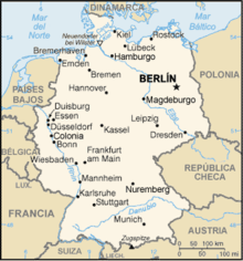
The Federal Republic of Germany (FRG; German: Bundesrepublik Deutschland) is a country in Central Europe that is part of the European Union (EU). It limits to the north with the North Sea, Denmark and the Baltic Sea; to the east with Poland and the Czech Republic; to the south with Austria to the southwest with Switzerland, and to the west with France, Luxembourg, Belgium and to the northwest with the Netherlands. Germany contains a vast diversity of landscapes. Mountains, forests, hills, plains, lakes, rivers, and coasts make up this great country.
Physical geography
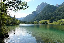
Germany consists of three major physiographic regions: a lowland plain in the north, Middle Germany which is a plateau area in the center, and a mountainous region in the south. The lowlands, which make up the North German Plain, have a varied relief that includes several river valleys and a large area covered with heather. The lowest point is the coastline. The eastern end of the plain has very rich soil for agriculture. The region of the central plateaus, whose approximate limits are between the city of Hannover in the north and the Main river in the south, covers a territory composed of gently rolling mountains, river valleys, rivers and well-defined basins. The mountain ranges include the Eifel and Hunsrück ranges in the west, the Taunus and Spessart mountains in the center, and the Fichtelgebirge chain. In the center are two mountainous areas called "forests": Thuringian Forest and Franconian Forest. At the northern end of the rolling region of Thuringia lies the Harz, a mountainous region. Much of southwestern Germany is occupied by two outcroppings of the Jura mountains and a large forest, the Black Forest, which is an old mountain massif. In the extreme south are the Bavarian Alps, with the highest peak in Germany, the Zugspitze (2,962 m).
Rivers, lakes and coasts
Most of the large German rivers are in the western part of the territory. The most important is the Rhine, which also functions as a natural border with Switzerland and France before flowing into the coast of the Netherlands. Among the tributaries of the Rhine are the Lahn, the Lippe, the Main, the Moselle, the Neckar and the Ruhr. Other important rivers are the Elbe, which runs from the Czech border in the southeast to the North Sea, and the Danube, which rises in the Black Forest and runs east into the Bavarian plateau; it receives the waters of the Lech, the Isar and the Eno, and ends up passing to Austria. The Oder, together with its tributary, the Neisse, forms most of Germany's eastern border with Poland.
Germany is bordered to the west by the North Sea and to the east by the Baltic Sea. The German coastline includes areas of dunes and salt marshes. Off the coast there are several islands, among which are the North Frisian Islands, the East Frisian Islands and the Island of Rügen in the Baltic Sea.
Extreme Points
This is a list of the extreme points of Germany, that is, the points that are farther north, south, east, or west than anywhere else:
- Northwest point — List, Sylt, Schleswig-Holstein (55°03′N, 8°24′E)
- Southwest point — Haldenwanger Eck, Oberstdorf, Bavaria (47°16′N, 10°10′E)
- West point — Millen, North Rhine-Westphalia (51°1′N, 5°53′E)
- More east — Deschka, Saxony (51°16′N, 15°2′E)
Climate
The country has a predominantly oceanic, temperate, and maritime climate with cool, often cloudy, and humid winters and summers. The weather is sometimes unpredictable. In the height of summer, one day can be hot and sunny and the next cold and rainy. However, truly extreme weather conditions, such as severe drought, tornadoes, hailstorms, extreme heat or cold, etc., are rare. Although large-scale floods have been seen in recent years, they are also generally rare. There is no news of destructive earthquakes.
Most of Germany lies in the cool/temperate climate zone with humid westerly winds. The maritime influence softens the western coast. The climate is moderated by the North Atlantic Current, which is a northern extension of the Gulf Stream. The warm waters brought by this current affect the coastal areas of the North Sea including the Jutland peninsula and the area along the Rhine, which runs in the direction of the North Sea.
In the north-west and north, the climate is oceanic (closer to the climate of the UK and the Netherlands) and rain can fall all year round. Winters are relatively mild and summers are comparatively cool.
In the east, the climate shows clear continental features: winters can be very cold for long periods and summers can be very hot. Here, too, long periods of drought have often been documented. In winter, Germany can come under the influence of the Siberian anticyclone. That determines that the temperatures are rather low, especially in this part of the country.
In the center and in the south there is a transitional climate that can be predominantly oceanic or continental, depending on the general weather situation. Winters are mild and summers tend to be pleasant, although maximum temperatures can exceed 30°C for several days in a row in heat waves. In the south, at the foot of the Alps, the weather phenomenon of warm mountain winds (the foehn) occasionally occurs. The warmest regions of Germany are in the southwest (see Upper Rhine and Rhenish Palatinate). Here the summers can be hot with a high number of days that exceed 30 °C. Sometimes the minimum temperatures do not drop below 20 °C, which is relatively rare in other regions. This type of climate allows viticulture, whose presence characterizes large parts of the landscape of southwestern Germany (German Wine, German Wine Route). Due to the mild climate, most of the wines produced are white, but red wine is also produced.
Precipitation decreases from south to north and from west to east. Thus, it is estimated that the maximum rainfall occurs in mountainous areas such as the Black Forest (up to 2000 mm), then it rains around 930 mm in Munich, and Hamburg, despite being close to the sea, barely receives 700 mm. To the east, the federal state of Saxony-Anhalt has the lowest rainfall in Germany, with the city of Quedlinburg receiving only 438 mm per year.
| Ene. | Feb. | Mar. | Open up. | May | Jun. | Jul. | Ago. | Sep. | Oct. | Nov. | Dec. | Year | |
| Average [°C] | -0.4 | 0.6 | 4.0 | 8.4 | 13.5 | 16.7 | 17,9 | 17,2 | 13.5 | 9,3 | 4.6 | 1.2 | 8.9 |
| Precipitations [mm] | 43 | 37 | 38 | 42 | 55 | 71 | 53 | 65 | 46 | 36 | 50 | 55 | 591 |
Source: "Berlin", in educaplus.org.
| Ene. | Feb. | Mar. | Open up. | May | Jun. | Jul. | Ago. | Sep. | Oct. | Nov. | Dec. | Year | |
| Average number (°C) | 2.6 | 2.9 | 6.3 | 9.7 | 14 | 16.6 | 18.8 | 18.1 | 14,5 | 10.6 | 6.3 | 3.3 | 10.3 |
|---|---|---|---|---|---|---|---|---|---|---|---|---|---|
| Precipitations (mm) | 62.1 | 54.2 | 64.6 | 53.9 | 72.2 | 90.7 | 85.8 | 75 | 74.9 | 67.1 | 67 | 71.1 | 838.6 |
Source: DWD - Cologne/Bonn Airport, Germany for 1981–2010
Environment
About 30% of the territory is made up of forests, most of which are found in the southern half of the country. About two-thirds of these forests are made up of pine and other conifers, with the rest made up of deciduous species such as beech, birch, oak and walnut. Vineyards cover many of the southwestern slopes of the country and also extend along the Rhine, Moselle and Main rivers. Vegetable gardens are a prominent feature in western Germany. The flora is of great variety and showiness.
Germany has 22,907 protected areas, covering 135,031 km², that is, 37.76% of the country's territory.
The dominant biome in Germany is temperate broadleaf forest, although to the south, in the Alps, temperate coniferous forest is present. WWF divides the territory of Germany into five ecoregions:
- Atlantic Mixed Forest, Northwest
- Baltic mixed forest in the northeast
- Central European Mixed Forest, East
- Forest of hardwoods in Western Europe, central and south
- Alps Forest, at the southern end, at the border with Austria
Wildlife
Germany has a little varied fauna. The most common mammals are deer, wild boar, weasel, badger, wolf, and fox. Among the few reptiles is a poisonous snake, the European viper. Finches, geese, and other migratory birds cross the country in large flocks. In the coastal waters of the North Sea and the Baltic Sea, fish such as herring, cod and plaice are found, while in the rivers there are carp, catfish and brown trout.
According to the regulations of the European Union, the territory of this country is divided into three biogeographical regions: continental, Atlantic and, in the part of the German Alps, the alpine biogeographical region. The following UNESCO World Heritage Sites stand out in its natural heritage: the Wadden Sea (2009), a natural asset that it shares with the Netherlands, and the Messel Fossil Site (1995). It has 15 biosphere reserves. 868,226 hectares are protected as wetlands of international importance under the Ramsar Convention, a total of 34 Ramsar sites. Finally, it has 14 national parks, including those of Harz and Jasmund.
The main natural hazard is flooding. Regarding environmental problems: emissions from coal burning and industries contribute to air pollution; acid rain resulting from sulfur oxide emissions is damaging forests; pollution in the Baltic Sea from the emission of sewage and industrial discharges from rivers in eastern Germany; hazardous waste disposal; the government established a mechanism to end the use of nuclear energy over the next fifteen years; The government is working to meet the European Union's commitments to identify nature conservation areas in line with the European Directive on the conservation of habitats, flora and fauna.
Human Geography
It has a population of 82,329,758 inhabitants (est. July 2009), 74% urban (2008).
The capital, Berlin, has a population of 3.4 million inhabitants, which makes it the most populous city in the country, as well as the fifth urban agglomeration among the countries of the European Union. More than eighty cities exceed 100,000 inhabitants, the top five being, after Berlin: Hamburg, Munich, Cologne, Frankfurt am Main and Stuttgart.
It is administratively divided into 16 states (in German, Länder, singular - Land): Baden-Wurttemberg, Bavaria, Berlin, Brandenburg, Bremen, Hamburg, Hessen, Mecklenburg-Western Pomerania, Lower Saxony, North Rhine-Westphalia, Rhineland-Palatinate, Saarland, Saxony, Saxony-Anhalt, Schleswig-Holstein, Thuringia. Bavaria, Saxony and Thuringia call themselves Freistaaten (singular, Freistaat), which means "free states".
Economic geography
Natural resources: coal, lignite, natural gas, ferrous ore, copper, nickel, uranium, potassium, salt, construction materials, wood and arable land, which represents 33.13% of land use. 0.6% is dedicated to permanent crops and another 66.27% (2005). Irrigated land represents 4,850 square kilometers (2003).
GDP (2009 est.) comes mainly from the service sector 72%, then industry (27.1%) and finally agriculture, which provides only 0.9%. At the same time, the majority of the active population (2005) works in services (67.8%), then in industry (29.7%) and finally a minority (2.4%) in agriculture.
The German economy, which is the fifth largest in the world and the largest in Europe, is a leading exporter of machinery, vehicles, chemical products and household equipment. You benefit from a highly-skilled workforce. Like its western European neighbors, Germany faces significant demographic challenges to sustaining long-term growth. Low fertility rates and declining net immigration will increase pressure on the country's welfare state system and it is in need of structural reforms. The modernization and integration of the East German economy, where unemployment can exceed 20% in some municipalities, remains a very expensive long-term term, with annual transfers from West to East reaching in 2008 alone to approximately twelve billion of dollars.
Contenido relacionado
Fasnia
Cordoba (Spain)
Saint Sebastian


