Geography of Burma
Burma is located between the Tibetan Plateau and the Malay Peninsula. It is surrounded on the east, north and west by mountains that limit a central valley, crossed by the Irrawady, Sittang and Salween rivers. The agricultural fields – rice producers – and most of the population are concentrated there.
Relief
Like most of the countries of Southeast Asia, Burma has a geomorphology and a hydrographic network oriented from north to south, which have conditioned human occupation.
Most of the relief is oriented from north to south, isolating the country from India to the west and Thailand to the east. The north, mountainous, announces the Himalayas. Is there the Hkakabo Razi, which culminates at 5,581 meters, making it the highest point in the country, and also in all of Southeast Asia. To the east, the Shan mountains form a continuity with those of Thailand and Laos (also populated by the Thaïs).
The only plains are found in the center and south of the country, along the rivers and estuaries: the Irawadi, the cradle of the Burmese people proper, and along the coasts, to the southeast, historical territory of the Mons.
The country descends from north to south in such a way that it is usually divided into Upper Burma (Upper Burma) and Lower Burma (Lower Burma). The central plain, through which the Chindwin and Irawadi rivers flow, is crossed by small undulating mountain ranges, Zeebyu Taungdan, Min-wun Taungdan, Hman-kin Taungdan and Gangaw Taungdan. When both rivers join and the central plain is dominated by the Irawadi in an absolutely flat area, another mountain range, Pegu Yoma, Bago Yoma or Bago Mountains, separates the large basin of this river to the east from the smaller one of the Sittang River, It empties into the Andaman Sea.
The mountains of northern Burma are formed by the southern slopes of the Hengduan Mountains, which lie mainly in China and form the southeastern rim of the Tibetan Plateau. To the west of Burma is found, from north to south, the Arakan mountain range, about 960 km long, culminating in Mount Nat Ma Taung or Mount Victoria, 3,053 m, and separates the country from India. This in turn is formed, in its northern part, by the Patkai mountains, the Naga mountains that culminate in Mount Saramati, at 3,826 m, already in India, and the Chin mountains. In the extreme south, the Arakan range continues and plunges into the Bay of Bengal, to emerge again in the Nicobar Islands, which belong to India. This region is dominated by an ecoregion called the Chin-Arakan Yoma Mountains montane forests.
In eastern Burma lie the Shan Mountains, also known as the Shan Plateau or the Shan Hills, a system mountain range 560 km long by 330 km wide that rises abruptly 600 m above the alluvial plain, and that in its eastern half is formed by numerous mountain ranges that rise from 1,800 to 2,600 m. The average altitude of the Shan Hills is 1,000 m and culminates in Loi Leng, 2,673 m. They are the source of Burma's third major river, the Salween River, which also empties into the Andaman Sea, in the Gulf of Martaban. The Shan Mountains extend beyond the Salween into the Daen Lao Mountains, and then into the Dawna Range, which culminates in the Mela Taung at 2,080m and separates the country from Thailand and Laos. This mountain range connects to the south with the Tenasserim mountains, which extend south through the Malacca peninsula, serving as a separation with Thailand, and which culminate in Mount Tahan, 2,187 m, already in Malaysia. These systems are formed by narrow valleys and rugged parallel mountain ranges.
Mount Hkakabo, the highest point in the country, in the north, with its almost six thousand meters forms a complex geological framework where the northeastern limit of the Indo-Australian plate and the southern edge of the Eurasian plate meet, which have been colliding over the last 50 million years to form the Burma mountain system.
Three-fifths of Burma, more than 400,000 km², is drained by the Irawadi River and its tributaries. The Irawadi is navigable for 1,600 km. At the apex of the delta (between 35,000 and 50,000 km², a part of which was destroyed by Cyclone Nargis in 2008) it opens into a vast network of channels that terminate in multiple mouths in the Andaman Sea. The Chindwin River drains the western part; the Pathein River drains the lower part of the Arakan Range and the Yangon River drains the Bago Mountains.
In the highlands the soils are dark red and brown, rich in iron and very fertile; when they are covered with forest they absorb well the water of the monsoon rains, but when they are deforested, they erode quickly. In the lowlands, the soils are silty and clayey, poor in organic matter, heavily washed by rain, and need fertilization. In the central lands, the soils are brown, rich in calcium and magnesium, but when the clay content is low, the heat causes them to yellow and become salinized.
Climate
The climate is tropical, with monsoonal rains between May and October. Much of the vegetation is jungle. Deforestation destroyed two thirds of the tropical forest.
The tropical monsoon occurs in the lowlands below 2000 m; cloudy, rainy, hot, humid summers (southwest monsoon, June to September); less cloudy, little rain, mild temperatures, lower humidity during winter (northeast monsoon from December to April). The climate varies in the highlands depending on the elevation; subtropical temperate climate at around 2,500 m, temperate at 3,000 m, cool, alpine at 3,500 m and above the alpine zone, cold, harsh tundra and arctic climate. The higher elevations are subject to heavy snowfall and severe weather.
The following climatic zones can be distinguished:
- The high mountains of the north, with perennial snows above 4500 m, in whose foothills the rains are abundant, with rains above 3000 mm, especially between May and October.
- The Arakán Mountains, west, and in the Shan Mountains, east, with a temperate climate and sometimes torrential rains during the monsoon to the west, and softer to the east, with about 1500 mm of annual precipitation. In Taunggyi, in the Shan Mountains, east, at 1400 m altitude, there are about 1,760 mm per year, mostly between May and November, with temperatures ranging from 7 to 22.orC in January and 17 and 27.orC in May, the warmest month, before the rains. The heat continues until October and when it stops raining at the low nights of 10.orC.
- A central area, including the capital, Naipyidó, of tropical climate, a little colder in the north, with strong but not exceptional rains in monsoon times. In Myitkyina temperatures range from 10 to 23.orJanuary C, and 22-24.orC minimums and 30-32.orC of summer peaks, hot and humid, between late April and October, with 2000 mm very concentrated between June and August.
- An inner area, protected from the monsoon, even arid, where Mandalay is located, very warm in the period prior to the rains. In Mandalay there are about 840 mm per year, between May and October, with temperatures of 24-26.orC minimums and 37-38.orC in April and May. In winter they go down to 13-15.orMinimum C and 28-29.orC maximums. In this area, which covers the cities of Mandalay, Mangyan, Magway and Bagan, the dry climate favors the type of dry forest characteristic of the center of Burma where the teak grows.
- The coast, with a fresh winter climate and warm in summer, and with very abundant monsoon rains. In Sittwe, capital of Arakán, on a nearby island of the estuary formed by the confluence of the rivers Kaladan, Myu and Lemyo, which flow into the Gulf of Bengala, the temperatures range from 15 to 28.orC's in the ring, and 25-32.orMay C, but the rains are 4.550 mm per year, with little precipitation between December and April, and with more than 1000 mm per month between June and August, more than 500 mm in September and about 300 mm in May and November. In July and August it rains 25 days from 30. In Rangún, which is also on the coast, in the mouth of the river Irawadi, but not so exposed to the south winds, the rains are half, with more than 500 mm per month in summer and 2,680 mm per year.
Main rivers
The Irawadi is the lifeblood of Burma. It rises in the highlands of the Kachin State and runs for approximately 2,000 km before flowing into the Andaman Sea, dividing into numerous arms. The river is navigable as far as Bhamaw in the south of Kachin State.
The Chindwin rises from several streams in the north of Sagaing (province) and empties into the Irawadi between Mandalay and Pagan. The ships date back to Leik Maw. In addition, only small boats can follow. During the dry season (February to May), large ships cannot sail to Kale Wa.
The Sittang rises from several streams in the Pegu Mountains and foothills of Kayin State and southern Shan State and empties into the Gulf of Martaban in the northern part of the Andaman Sea. The river is not navigable for passenger boats due to its strong currents and rapids. Portions of the river and its tributaries are used for the transport of logs.
The Salween originates in China and flows through the Shan States, Kayah State, Kayin, Mon and empties into the Gulf of Martaban near Mawlamyaing. It forms the border between Thailand and Kayin State. Large passenger ships can go up to Shwe Gun in the high water season (June to November). The northern part is formed by rapids and strong currents in the mountains.
The Mekong forms the border between Laos and Shan State.
Protected areas of Myanmar
The IUCN considers that in Myanmar (also Burma) there are 59 protected areas that cover an extension of 42,878 km², 6.37% of the national territory, and 11,964 km² of marine areas, 2.33% of the 514,147 km² that belong to the country. Of these, 6 are national parks, 4 are ASEAN Heritage Parks, 2 are nature reserves, 4 are protected areas, 28 are nature sanctuaries, 3 are bird sanctuaries, 1 is a nature park, 1 is a mountain park, 2 are ASEAN nature sanctuaries and heritage parks, and 1 is an elephant range. There are also 2 Unesco biosphere reserves and 5 Ramsar sites.
National Parks of Myanmar
- Alaungdaw Kathapa National Park (ASEAN)
- Hlawga National Park
- Khakaborazi National Park (ASEAN)
- Lenya National Park
- Lenya National Park (Extension)
- Lanbi Island National Marine Park (ASEAN)
- Loimwe National Park
- Nat Ma Taung National Park (ASEAN)
- Monte Popa National Park
- Tanintharyi National Park
Ethnic groups of Burma
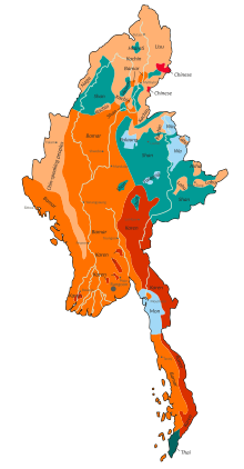
There are 13 government-recognized ethnic groups in Burma, grouped into eight major groups. The Bamar population is more numerous because the government groups all mixed groups into that ethnic group. In order: bamar, chin, kachin, kayin, karenni, mon, rakhine and shan. The largest groups are grouped primarily by region, rather than by language or ethnic affiliation, for example, the Shan national ethnic group includes 33 ethnic groups that speak languages belonging to at least four different language families. There are many unrecognized ethnic groups, the largest of which are the Chinese population of Burma and the Panthays, Muslims of Chinese origin who together make up 3% of the population of Burma, Burmese Indians, who make up 2% of the population, the Anglo-Burmese and the Gurkha Burmese. The Rohingya would form 1.8% of the population before their expulsion.
Contenido relacionado
Annex: Municipalities of the province of Cádiz
Asaka (Saitama)
Gulf of mexico


