Gaul
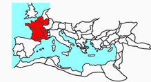
Gaul (Latin: Gallia) is the Roman name given to a region of Western Europe currently occupied by France, Belgium, western Switzerland, northern of Italy and areas of Germany and the Netherlands west of the Rhine. Also the British Isles (Wales, England and Ireland) and Hispania were populated by Celtic tribes. Thus, the word Gallic (Latin: gallus) usually refers to the Celtic inhabitants of that region in ancient times and was mainly used by the Romans, who very rarely They called this set of diverse tribes Celts. The name was preserved through time only in the extension of lands that today make up France and even today the French continue to be called Gauls, and in fact Gallia (in Greek Γαλλία) is the modern Greek name for France. Also the name of Galicia has the same origin referring to the Gallic or Celtic population.
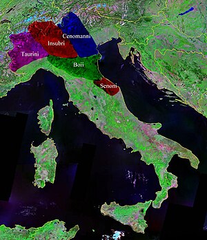
However, the Gauls spread throughout Europe in Roman times, speaking Celtic languages that had diverged into two groups. In addition to the Gauls of present-day France, others had settled in the plains of northern Italy, in the province known to the Romans as Galia Cisalpina ("Gaul beyond the Alps", which, Later, it definitively ceased to exist as a province, being annexed to the territory of Roman Italy, in the I century BC.), to Veneto and Istria. Other Gauls had emigrated crossing the Pyrenees to Iberia, also giving rise to the Celtiberians by mixing with the indigenous Iberian substratum.
Early days
The Phocian Greeks founded a city called Massilia (present-day Marseille) in the south of these territories. From this time we have the first data and information about Gaul and the Gauls. The Greeks called keltoi (which means in Greek: the bold, due to their great courage), in general those who are known as Celts, but in these regions they also used the name Galatia and galatians (in ancient Greek, Γαλατης), to designate the earth and its inhabitants. This term Galatian refers both to the European inhabitants and to those who later settled in Asia Minor, founding the region of Galatia. The Celts have always called themselves galiain, that is: Gauls. These two terms of Gaul and Gauls continued to be used after Julius Caesar's conquest to designate the Roman provinces that extended through these territories and were preserved until the end of the Merovingian dynasty, at least in the documents of the time. Later, and already at the height of the Carolingian dynasty belonging to the Kingdom of the Franks, the term Francie (Francia occidentalis) arose, designating the territories of ancient Roman Gaul.
There was no political or territorial unit in Gaul. They did not constitute an organized State, but a group of peoples made up of different tribes and of different ethnic groups. If there was something that united this set of tribes, it was trade, above all, based on a developed metallurgy.
The different peoples of Gaul
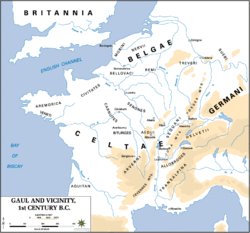
Julius Caesar gave a general description of three of the peoples that inhabited Transalpine Gaul in his book De Bello Gallico (Commentaries on the Gallic Wars). He tells that the region was divided into three parts, each of which was inhabited by the people of the Belgians , the Aquitanians and the Gauls (or Celts). Although he only describes these three, it is known that Gaul was populated by many more different peoples. But it must be borne in mind that in this description is Caesar's will to set limits, typical of all Romans, who did not have any kind of scientific basis to catalog differences between one people or another. The Belgians inhabited the northern part; to the south of their region were the Sequana (Seine) and Matrona (Marne) rivers. The Celts proper, according to Julius Caesar, inhabited the central part. The individuals of these two towns were tall, fair-skinned, quite sociable, and were in the habit of fighting in large groups. The Aquitanians lived in the south, between the Garonne river and the Pyrenees mountains; they were dark and fought in small groups. They spoke different languages and their customs and laws were not common either.
Each town was made up of several tribes:
- Traditional Celtic, with the carnuts, bituriges, namnets, pictons, turons, senones, heduos, arvernos, which were scattered along the river Loire. Tricasses, lingones, mandubes, in the Seine River basin. Tréveros, leucos, tribocos, secuanos among others, inhabiting the Moselle River basin. Helvecios, ráuracos, ambarros, alóbroges, segusiavos, helvios, voconcios, saluvios, among many others, along the rivers Ródano and Saona.
- Belgian Celts, with the tribes of the belovacs, successions—which gave rise to the toponym of Soissons—remos—that gave rise to the toponym of Reims—Parisians—whose capital was Lutecia, today Paris—, menapios, darts, ambianos, meldos, catalauns, murins, batons, nerves and eburets.
- Aquitaine., with the tribes of the tarbelos, auscos, nitióbroges, elusates, convenos, viviscos and others, more linked with the Celtic peoples of the Iberian peninsula, although the anthroponymy of the ancient aquitanus shows protoeuskérico elements.
In Roman times
All the lands inhabited by the Gauls were known by the Romans as the Gauls, in the plural, because Rome distinguished more than one, depending on its geographical location. That is why they distinguished between Galia Cisalpina (to the north of Italy, before passing the Alps) and Galia Transalpina (beyond the Alps, from the north of Italy); apart from the many territories that were still unconquered until the time of Julius Caesar (Galia Comata or Cabelluda).
Cisalpine Gaul
The Cisalpine Gaul was called, by some authors, as Galia Italica and also called Gaul citerior or Galia togata, due to its early and deep Romanization compared to the other Gauls. It was made up of all the lands north of the Arnus (Arno) and Rubicon rivers, rivers that also delimited the land border between Italy and the provincial territories.
The Po River runs through this territory from west to east, tracing a natural geographic dividing line. At that time, the dividing of the river was very important, since there was a great difference between the inhabitants of one bank and the other. The people south of the Po River, in the so-called "Galia Cispadana", were highly Romanized and, since the times of the Social War, enjoyed full Roman citizenship, which had been granted to them through the Lex Plautia Papiria in the same way as the Italics, while, in the territory between the northern bank of the Po River and the Alps, in what was known as "Galia Transpadana", the people and cities were quite less romanized (although more than in the Transalpine Gauls) and enjoyed exclusively Latin law.
Up to the middle of the century I a. C., in Transpadana, the cities of Aquilea, Cremona and Mediolanum, were the only ones to enjoy full Roman citizenship, thus differentiating itself from the other transpadan cities provided only with the Ius latii; In the year 49 BC, thanks to the Lex Roscia, full Roman citizenship is granted to all the free inhabitants of Galia Transpadana, which in the year 42 B.C., together with Galia Cispadana —the two territories that made up Galia Cisalpina— definitively ceased to be a province and to be known by this name, being annexed to the territory of Roman Italy and becoming, since then, the northernmost of the Italic lands.
Transalpine Gaul
Called by some later Gaul, it was the Roman province that lay on the other side of the Alps. It consisted of a coastal strip from the western limit of Liguria to the northern Pyrenees. Along the strip he had two outposts that went inland, one towards Tolosa in Aquitaine, and another through the Rhone valley to the factory or commercial city called Lugduno, present-day Lyon. It was conquered for the most part by Cneo Domicius Enobarbo, before the year 120 BC. C., with which the passage of the Roman armies towards Hispania was ensured.
Galia Comata
Also called Longhaired Gaul (coma in Latin means "mane, hair"), since its inhabitants grew their hair very long. It was the largest Gaul of all, since it included present-day France and Belgium together with part of the Netherlands south of the Rhine River. Its territory was flat, with large forests and many agricultural resources, most of them unexploited. It was irrigated by the rivers Liger (Loire), Sequana (Seine), Meuse, Mosella (Moselle), Scaldis (Scheldt), Samara (Somme), Matroma (Marne), Duranius (Dordogne), Oltis (Lot) and Garumna (Garonne).).
Before Julius Caesar's conquest, all these lands were virtually unknown. Its inhabitants were Celts (Gauls) for the most part. These Gauls knew of the existence of Rome and its power and avoided any contact with it. They were farmers and herders and lived in towns that the Romans called oppida. They jealously guarded, cared for, and defended tribal treasures, as well as wheat fields and their king. Little is actually known about their religion, although legends and tales have circulated throughout history about their gods (linked to nature like the Viking gods) and their priests, called druids (of whom almost everything is unknown, there are to investigate other fields to understand them, such as current shamanism). In general they did not seek war as an end for their expansion, but they were terrible warriors. They used to make and drink beer. Most of these inhabitants were tall, stocky, blond or red-haired, and with blue or gray eyes. For the Romans they were barbarian peoples, that is, foreigners, since they spoke a language completely different from Latin.
Roman conquest
Julius Caesar defeated the Celtic tribes in Gaul between 58 and 51 BCE. C. and wrote about his experiences in De Bello Gallico (Comments on the Gallic War). The region conquered by Caesar was Galia Transalpina, where Galia Comata (Galia Lenuda) was included. Caesar described the Gauls as intelligent, highly active, impulsive, and unstable individuals.
When Caesar arrived in Gaul in 58 B.C. C., these territories were just a name for the Romans, who only knew the southern provinces, subjected to vassalage in order to ensure passage and communications by land to Hispania. The Romans knew that its inhabitants were Celtic tribes that were in continuous warfare. Caesar went to the territory of Gaul to help the people of the Helvetii, established in what is now Switzerland, who were threatened by the Germans. However, Caesar prevented the migration of the Helvetian tribes to the east, which he definitively defeated near Bibracte and which he ordered to return to his lands. He later went to the aid of the Aedui who were fighting against the Belgians; after these feats, he decided to settle there and, in the year 56 a. C., he fought a naval battle against the Venetian Gauls, a native people of northwestern France.
In the year 55 B.C. C., the Germans were very close to him, on the other bank of the Rhine. He ordered his legion to build a wooden bridge over this river to be able to cross it and fight against this people in his territory. In this way, Caesar prevented a new invasion. There were two brilliant and reckless campaigns against Ariovisto, the German chief, who despite being his army much larger than him, was annihilated by the Romans near Ostheim (in present-day Alsace, France).
In 60 B.C. C. are estimated at 5 to 6.7 million people, in year 0 there are 8 million inhabitants of the province, for the year 400 there are an estimated 12.2 million people[citation required]. Emperor Augustus divided Gaul in the year 27 into four administrations or provinces:
- Gallia Aquitainewhich bordered the river Loire to the north.
- Gallia Belgica, which spread between the Seine and Rin rivers and whose boundary by the north was the North Sea. This administration was maintained until the beginning of the centuryIVThere were changes with the emperor Diocletian.
- Gallia Lugdunensisbetween the rivers Loire, Saona and Ródano.
- Gallia Narbonensisfrom the Alps to the Cevenas mountains.
Historian Robert Étienne has calculated an urbanization rate of 7.6% for Gaul in the High Roman Empire.
The Gallic Empire
During the III century, a government separate from Rome was formed in Gaul, which has been called Gallic Empire.
The Gallic Empire included Gaul, Hispania, Britain and part of Germany. It had an emperor, a Gallo-Roman nobility, an army with its respective generals and officers, and its own economy represented by the minting of its imperial coins. In his international relations, he highlighted a border delimitation pact agreed with the Roman Empire.
Initially, its provinces had an apparently much more prosperous economy than the economy of the Roman provinces. However, a subsequent economic crisis, coupled with the political crisis, meant the end of this empire produced in the midst of the unrest of the peoples characteristic of the end of the Ancient Age. After that, nothing would be the same in Gaul, not even with its ephemeral reincorporation into the Roman Empire.
The Germanic peoples
In 254, the limes of Germania Superior fell, and around 259 important barbarian contingents entered Belgium. Between 268 and 278, the interior of Gaul was sacked and some groups reached Hispania. Until around 278 the border was reestablished by the emperor Probus.
On December 31, 406, the Alans, Suevi, and Vandals crossed the Rhine and invaded Gaul. After coming under increasing pressure from Germanic tribes since the middle of the III century, Roman rule in Gaul ended with the defeat of the Roman governor Siagrio by the Franks in 486. Romanization had lasted until the 5th century. After the fall of the Western Roman Empire, the Franks (Germanic people) settled in northern Gaul. From then on it began its expansion throughout the territory. However, the illustrious Gallo-Roman families continued to have political power.
Contenido relacionado
Annex: Chronology of Chile
28th century BC c.
International Civil Aviation Organization


