
Ganges
The Ganges or Ganga —in Sanskrit and most Indian languages, gáṅgā, meaning “go, go”, that is, "that moves quickly"; in Devanagari script, गंगा; in the IAST system of transliteration, gaṅgā— is an international river of the Indian subcontinent that flows through India and Bangladesh. The 2525 km stream rises in the western Himalayas in the Indian state of Uttarakhand and flows south and east across the plain gangetica of North India. After entering West Bengal, it splits into two distributaries: the Hooghly, or Adi Ganga, which flows through various districts of West Bengal and empties into the Bay of Bengal near Sagar Island; and the Padma, which flows through Bangladesh, joining the Meghna which also eventually empties into the same bay. The mouth, where the Brahmaputra also reaches, forms the Ganges delta, the largest in the world known as the Sundarbans ("beautiful forests"), a region of thick mangrove forest and one of the main habitats of the Bengal tiger. It is home to the Sundarbans National Park and has been declared a World Heritage Site by Unesco in 1997.
The Ganges and its tributaries drain a fertile basin of 907,000 km² that supports a highly concentrated population, with one of the highest densities in the world (in 2005, one in twelve people in the world lived in the region). Its average depth is 16 m and maximum 30 m. It is the most important of the seven sacred rivers of Hinduism in which millions of worshipers bathe to purify themselves. Indians go to the river to die in droves in the belief that dying in the Ganges, and especially in Varanasi, in the left bank, makes it possible to end the cycle of reincarnations and achieve moksha (the Buddhist equivalent of nirvana). He is personified as Maa Ganga (mother Ganges) or Ganga Deví (goddess Gaṅgā). According to tradition, in time immemorial the waters of the Ganges crossed the sky, while the desert lands of India perished of thirst.
King Bhagiratha raised prayers to the gods so that the sky would irrigate the thirsty lands with its waters; the gods attended to him and sent the waters to the earth, although they fell with such violence that they threatened to reap the lives of all men. Then the miracle happened: Shiva, pitying the troubled humanity, made the waters fall on his head and slide down his long hair for a thousand years, before the sacred river was born in the Himalayas, gentle and moderate, without danger to the humans. men.
It is also vital for the 400 million Indians who still today live near its course and depend on it for their daily needs. Historically, it has also played an important role as the backbone and livelihood of many former provincial or imperial capitals (such as Kannauj, Kamilya, Kara, Prayag or Prayagraj, Kashi, Pataliputra or Patna, Hajipur, Munger, Bhagalpur, Baranagar, Murshidabad, Baharampur, Nabadwip, Saptagram and Calcutta). It is, however, one of the most polluted rivers in the world and a major source of ocean pollution worldwide due to the dumping of plastic waste. A study developed by the Helmholtz Center for Environmental Research and published in 2018 ranks it as the first of the 10 rivers that contribute the most to marine pollution since it carries 545 million kilos of plastic waste annually. The levels of fecal coliform bacteria from human waste in the waters of the river near Varanasi exceed half a million times the limit official government of India. The Ganges Action Plan, an environmental initiative to clean up the river, has been a major failure so far, due to corruption, lack of will on the part of the government and its bureaucracy, lack of technical expertise, poor environmental planning, and lack of support from religious authorities.
Its high pollution is a threat to humans and wildlife, which involves some 140 species of fish, 90 species of amphibians and two species of dolphins, the endangered Gangetic dolphin and the Irrawaddy dolphin. It is also interesting for a rare species of shark, the Glyphis gangeticus, whose conservation is considered critically endangered.
Geography
Course
Upper Course: In Uttarakhand


Its main course begins at the confluence of the Bhaguirati and Alaknanda rivers in the city of Devprayag in the Garhwal division of the Indian state of Uttarakhand. In Hindu culture and mythology, the Bhagirathi is considered to be the source of the Ganges, although the Alaknanda is longer, and therefore hydrologically the true source.
The headwaters of Alakananda, located in the Nanda Devi National Park (1982, a World Heritage Site since 1989), are formed by melting snow from peaks such as Nanda Devi el Trisul and Kamet. The Bhagirathi is born at the foot of the Gangotri glacier, in Gomukh, at an altitude of 3892 m, being mythologically named as the one who resides in Shiva's locks, symbolically Tapovan, a meadow of ethereal beauty at the foot of Mount Shivling, just 5 km away.
Although many small streams feed the headwaters of the Ganges, the six largest—the Alaknanda, Dhauliganga Nandakini Pindar Mandakini, and Bhagirathi rivers—and their five confluences, known as the Panch Prayag (lit., &# 39;five confluences'), all in the course of the Alaknanda. They are, in descending order, Vishnuprayag (a 1372 m s. n. m., where it joins the Alaknanda the Dhauliganga), Nandprayag (at 870 m, where it meets the Nandakini, a small town that once had 1,433 in 2001), Karnaprayag (at 730 m, where the Pindar meets, and which had 6976 inhab. in 2001), Rudraprayag (at 610 m, where the Mandakini meets, with 19,313 inhab. in 2011) and finally, Devprayag (at 475 m, where the Bhagirathi joins the Alaknanda to form the Ganges River itself), a town with 12,144 inhabitants as of 2001, and a major pilgrimage site.
- The five confluences

Vishnuprayag (where the Dhauliganga joins Alaknanda)

Nandprayag (where the Nandakini joins)

Karnaprayag, where the Pindar joins

Rudraprayag (where Mandakini joins)

Devprayag, where the Bhagirathi joins the Alaknanda, to form the Ganges himself


After traversing 250 km through its narrow Himalayan valley from its headwaters, the Ganges emerges from the mountains at Rishikesh, a holy and pilgrimage city, considered the "Gateway to the Garhwal Himalayas" and the "Yoga Capital of the World".

Then it enters the Gangetic plain and a little more than 10 km to the south it reaches another holy pilgrimage city, Haridwar where in the Hindu tradition the goddess Ganga appeared when Shiva released the mighty river from the locks of her hair. Haridwar is considered as one of the seven holiest places (Sapta Puri) for Hindus. According to the myth of the Samudra manthan,[citation needed] is — along with four other sites, Ujjain, Nashik and Prayagraj — where drops of Amrit, the elixir of immortality, were accidentally spilled from the jar while it was being carried by the sky bird Garuda. Brahma Kund, the place where Amrit fell, is located on Har ki Pauri (lit. 'steps of the Lord') and is considered the holiest ghat in Haridwar.
This is manifested in the Kumbha Mela pilgrimage, held every 12 years, when millions of pilgrims, devotees and tourists flock to the city for a ritual bath in the Ganges to wash away their sins and attain moksha. Haridwar is also the center of another pilgrimage, the Kanwar pilgrimage, in which millions of participants collect holy water and carry it hundreds of kilometers to offer at Śiva shrines. In September 2015, the Union Minister of Tourism, Mahesh Sharma, announced that Rishikesh and Haridwar will be the first cities in India to receive the title of "national heritage twin cities".
At Haridwar, a dam, located at about 300 m s. no. m., diverts part of the river waters towards the Ganges channel, built by the British between 1842 and 1854 that irrigates the Doab region of Uttar Pradesh. The Ganges, which had been running roughly southwest at this point, begins to turn southeast to describe a wide arc of about 800 km across from the plains of northern India, which is called by him the gangetic plain, a plain with little unevenness and in which it receives numerous and long tributaries. Shortly after entering the plain, it leaves the state of Uttarakhand and enters Uttar Pradesh, at its northwestern tip.
In Uttar Pradesh


Pass through the cities of Bijnor, Anupshahar, Narora, Kachhla and Kannauj (former imperial capital of the Pushyabhuti dynasty in the late VII century) ). The Ganges then continues its advance in a south-westerly direction through Farrujābād and receives, on the left bank and coming from the Himalayas, the Rāmgangā river, which provides it with an average annual flow of about 500 m³ /s. It then passes through Bithoor (a Hindu pilgrimage town, which would be the birthplace of Rama's sons Luv and Kush) and finally reaches Kanpur.
Just before entering Kanpur it is dammed by the Ganges dam, a 621 m dam inaugurated in 2000 that wants to change the appearance of the city by arranging a botanical garden and conditioning the canalized channel as it passes through the city. Leaving Kanpur, it passes one of its suburban cities, Jajmau, an important industrial center that has the largest leather companies and where the Kanpur airport is located.
It then joins the Yamuna River at the Triveni Sangam, near the holy city of Prayag, now Prayagraj, at a confluence sacred to Hinduism. At this confluence the Yamuna is larger than the Ganges itself, contributing approximately 2950 m³/s, approximately 58.5% of the combined flow. Off the confluence is the city of Jhusi.
It continues to the east and meets the Tamas River (also called Tons or Tauns), which enters it from the south coming from the Kaimur range and contributes with an average flow of about 190 m³/s. Continue through the small town of Sirsa where there is a power station of NTPC Limited, Chunar, Mirzapur and Benares (Varanasi).
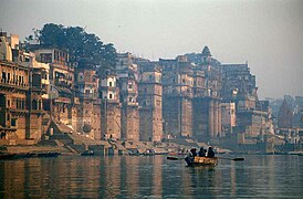
The city of Varanasi has 88 world-renowned ghats, most of them for bathing and puja ceremony, with only two used exclusively as cremation sites. The long stretches of ghats, tiled stands of stone where pilgrims perform ritual ablutions, they enhance the river bank with a large number of shrines, temples and palaces built on the water's edge.
Most of the ghats were rebuilt after 1700, when the city was part of the Maratha Empire. (They were patronized by Marathas (Scindias), Holkars, Bhonslees and Peshwas). Many ghats are associated with legends or mythologies, while many others are privately owned. A popular attraction among visitors to the city is a morning boat ride on the Ganges through the ghats, the most famous being Dashashwamedh, Manikarnika and Panchganga.
- The Ganges in Benares

Dawn in the Ganges near Benares
The Ganges on his way to Benares

Hindu temples behind Manikarnika Ghat

Ceremony at dawn


.jpg)


Shortly after leaving Benares, the Ganges receives the Gomti River, which flows north from the Himalayas, contributing an average annual flow of 234 m³/s, before reaching the small town of Saidpur. It continues its slow progress and the river passes through Zamania - a sacred place since the Ganges flows north - and reaches Ghazipur, well known for its opium factory, established by the British East India Company in 1820 and which is still the The largest legal opium factory in the world, producing the medicine for the world pharmaceutical industry. After traveling about 40 km, it reaches Chausa, where it receives the short Karmanasa river on the right, at whose confluence begins a section in which the Ganges will be the state border between Uttar Pradesh to the west and Bihar to the east. At Chausa, a notable battle took place between the Mughal Emperor, Humayun, and the Afghan Emperor, Sher Shah Suri. He fought on June 26, 1539, and Sher Shah emerged victorious, crowning himself Farīd al-Dīn Shēr Shah. At the beginning of the border section, the Ganges passes in front of Buxar to Ballia and then reaches the city of Chhapra in Bihar, at the confluence with the Ghaghara River, which comes from the west and also flows from the Himalayas of Nepal, with a mean annual flow of 2990 m³/s, the largest of its tributaries. Chhapra grew in importance as a river market in the 18th century when the Dutch, French, Portuguese and English established nitrate refineries on the the area. Finally he goes into the state of Bihar.
In Bihar


Shortly after entering Bihar, the Ganges receives on the right bank, coming from the southwest, the Son River, the longest of the southern tributaries, which contributes about 1000 m³/s. Soon after it reaches the capital of Bihar, Patna, where it receives from the left, coming from the north, the Gandak River flowing from Nepal and contributing 1654 m³/s. Patna, built on the remains of Pataliputra, the former capital of the Maurya Empire, is today a commercial center for agricultural products (rice, corn, wheat, soybeans, sesame, sugar cane, linseed) and also an important craft center (weaving cotton and silk; goldsmithing, metallurgy and ceramics). Opposite Patna, on the left bank between the Ganges and Gandak, are Hajipur and Sonpur, once famous for its long railway platform (8th in the world), it is also home to Asia's largest Cattle Fair which It begins on Kartik Poornima (full moon), with a duration between fifteen days and a month, in the month of November-December and is celebrated on the banks of the Ganges-Gandak.
Continue west passing through Begusarai, Barauni, the twin cities of Jamalpur and Munger, Sultanganj and Bhagalpur, city of Silk, traditionally dedicated to silk industry and today an educational, commercial and political center, listed for development in within the framework of the "Smart City" programme, a joint initiative between government and industry.
In this section there is a stretch of about 50 km protected since 1991 as Vikramshila Gangetic Dolphin Sanctuary, a river sanctuary established to protect the gangetic dolphin, —declared as India's National Aquatic Animal, decision taken in October 2009 at the first meeting of the National Ganga River Basin Authority (NGRBA)—, and also the "Rehabilitation Area for Garuda is Bhagalpur”, dedicated to safeguarding the argala marabou (Garuda, a mythological god similar to the phoenix), a large bird of which barely 1000 specimens remain in the world.
It then receives from the left, near Kursela and coming from the northwest, the Kosi River which flows from Nepal, contributing approximately 2166 m³/s, respectively. The Kosi is the third largest tributary of the Ganges, after the Ghaghara and the Yamuna.
In Jharkhand-West Bengal
After reaching Sahibganj, home to one of the oldest universities in the world, Vikramashila, the Ganges begins to flow in a S-SE direction and a new stretch of border begins, first between Bihar and Jharkhand and then Jharkhand and West Bengal, where it enters a section of less than 20 km, in which it passes in front of Pakur, where it begins to wear down with the ramification of its first distributary, the Bhāgirathi -Hooghly, which will become the Hooghly River. Just before the border with Bangladesh, the Farakka Dam controls the flow of the Ganges, diverting some of the water into a feeder channel connected to the Hooghly in order to keep it relatively free of sediment.
The Hooghly is formed by the confluence of the Bhagirathi River and the Jalangi River at Nabadwip, and the Hooghly itself has several tributaries. The largest is the Damodar River, which runs south of Calcutta, with a basin of 25,820 km². The Hooghly empties into the Bay of Bengal near Sagar Island. Between Malda and the Bay of Bengal, the Hooghly passes through the towns and cities of Murshidabad, Nabadwip, Calcutta, and Howrah.
Shortly after Farakka, the Ganges once again becomes the border, this time an international one, between West Bengal and Bangladesh. In this section it passes in front of Suti, Aurangabad Chapai Nawabganj Lalgola and Godagari Rajshahi, the city of Silk and capital of the division of Rajshahi and Charghat and then enters Bangladesh, where it is now renamed the Padma River.
In Bangladesh

After entering Bangladesh, the Padma is joined by the Jamuna River, the largest distributary of the Brahmaputra River. Later, the Padma joins the Meghna River, the second largest distributary of the Brahmaputra, and takes the name Meghna when it enters the Meghna estuary, which empties into the Bay of Bengal. The Bengal Fan (Bengal Fan) is formed here, the largest underwater fan in the world, about 1430x3000 km than the only represents between 10-20% of global organic carbon burial.
The Ganges delta, formed mainly by the large sediment-laden flows of the Ganges and Brahmaputra rivers, is the largest delta in the world, with approximately 59,000 km². It stretches 322 km along the Bay of Bengal.
Only the Amazon and Congo rivers have a mean flow greater than the combined flow of the Ganges, Brahmaputra, and Surma-Meghna river system. At peak times, only the Amazon is larger.
Geology
The Indian subcontinent lies on top of the Indian tectonic plate, a minor plate within the Indo-Australian plate. Its defining geological processes began 75 million years ago, when, as part of the southern supercontinent of Gondwana, a drift began northeastward—for fifty million years—across a then-unformed Indian Ocean. The subcontinent's subsequent collision with the Eurasian plate and subduction beneath it gave rise to the Himalayas, the highest mountain ranges on the planet. On the ancient seafloor, immediately to the south of the emerging Himalayas, plate movement created a vast rift, which gradually filled with sediment contributed by the Indus and its tributaries and the Ganges and its tributaries, a basin of eave or edge. which now forms the Indo-Gangetic Plain.
Hydrology


The main tributaries of the Ganges are, on the left bank, the Gomti, the Ghaghara, the Gandaki and the Kosi rivers; and on the right bank, Yamuna el Son Punpun and Damodar. The hydrology of the Ganges River is complicated, especially in the delta region. And that causes the different ways of determining the length of the river, its discharge, and the size of its drainage basin.
The name Ganga is used to designate the river between the confluence of the Bhagirathi and Alaknanda rivers, in the Himalayas, and the border between India and Bangladesh, near the Farakka dam and the first river fork. The length of the Ganges is often said to be just over 2500 km. In these cases, the source of the river is generally assumed to be the source of the Bhagirathi River, the Gangotri Glacier at Gomukh, and its mouth is the mouth of the Meghna River in the Bay of Bengal. The source of the Ganges is sometimes considered to be at Haridwar, where the headwaters of the Himalayas flow into the Gangetic plain.
In some cases, the length of the Ganges is given with that of one of its distributaries, the Hooghly River, which is longer than its main outlet through the Meghna River, resulting in a total length of 2620 km, from the source of the Bhagirathi, or 2135 km, from Haridwar to the mouth from Hooghly. In other cases, the length is said to be about 2,240 km, from the source of the Bhagirathi to the border of Bangladesh, where its name changes to Padma.
For similar reasons, sources differ on the size of the basin drained by the river. The basin comprises parts of four countries, India, Nepal, China and Bangladesh; and from eleven Indian states, Himachal Pradesh, Uttarakhand, Uttar Pradesh, Madhya Pradesh, Chhattisgarh, Bihar, Jharkhand, Punjab, Haryana, Rajasthan, West Bengal, and the Union Territory of Delhi. The Ganges basin, including the delta but not the Brahmaputra or Meghna basins, is about 1,080,000 km²), of which 861,000 km² are in India (about 80%), 140,000 km² in Nepal (13%), 46,000 km² in Bangladesh (4%) and 33,000 km² in China (3%). Sometimes, watersheds the Ganges and the Brahmaputra-Meghna combine for a total of approximately 1,600,000 km². The Combined Ganges-Brahmaputra-Meghna Basin (abbreviated GBM or GMB) is a basin that drains parts of Bangladesh, Bhutan, India, Nepal, and China.
The basin stretches from the Himalayas and Transhimalayas in the north to the northern slopes of the Vindhya range in the south, from the eastern slopes of the Aravalli range in the west to the Chota Nagpur plateau and the Sundarbans delta, in the east. A significant part of the Ganges discharge comes from the Himalayan mountain system, in which the Ganges basin extends almost 1200 km from the Yamuna-Satluj divide to along the Simla range, which forms the boundary with the Indus basin in the west, to the Singalila range along the Nepal-Sikkim border, which forms the boundary with the Brahmaputra basin in the east. This section of the Himalayas has 9 of the world's 14 highest peaks over 8000m, including Mount Everest, which is the highest point on the Ganges basin. The other peaks over 8000 m in the basin are Kangchenjunga, Lhotse, Makalu, Cho Oyu, Dhaulagiri, Manaslu, Annapurna and Shishapangma. The part of the Himalayan basin includes the south-eastern part of the state of Himachal Pradesh, the whole of the state of Uttarakhand, the whole of the country of Nepal and the extreme north-western part of the state of West Bengal.
.JPG)
The discharge of the Ganges is also differentiated according to the source and is often considered to be at the mouth of the Meghna river, thus combining the Ganges with the Brahmaputra and Meghna. This results in a total average annual discharge of approximately 38,000 m³/s, or 42,470 m³ /s. In other cases, the average annual discharge of the Ganges, Brahmaputra and Meghna are given separately, approximately 16,650 m³/s for the Ganges, approximately 19,820 m³/s for the Brahmaputra, and approximately 5,100 m³/s for the Meghna. The maximum peak discharge of the Ganges, as recorded at the Hardinge Bridge in Bangladesh, exceeded 70,000 m³/s. The minimum recorded at the same location was of approximately 180 m³/s, in 1997.
The average monthly flow has been recorded at the Farakka hydrological station, at an altitude of 19 m and with a basin of 833,000 km² in the period 1949 -1973, with a mean monthly maximum of 60,000 m³/s and a minimum of 1041 m³/ s.
| Average monthly Ganges flow rate at Farakka hydrological station (Data calculated in the period 1949-1973, 24 years) (in m3/s) |
 |
The hydrological cycle in the Ganges basin is governed by the southwest monsoon. About 84% of total rainfall occurs in the monsoon from June to September. Consequently, the current flow in is highly seasonal. The average dry season to monsoon discharge rate is about 1:6 as measured at the Hardinge Bridge. This strong seasonal variation underscores many land and water resource development problems in the region. The seasonality of the flow is so acute that it can cause both droughts and floods. Bangladesh, in particular, frequently experiences drought during the dry season and regularly experiences extreme flooding during the monsoon.
Many large rivers meet in the Ganges delta, merging and forking into a complicated network of canals. The two largest rivers, the Ganges and the Brahmaputra, both divide into distribution channels, the largest of which merges with other large rivers before rejoining. This current channel pattern was not always the case. Over time, the rivers in the Ganges delta have changed course, sometimes changing the channel network significantly.
Before the end of the 12th century, the Bhagirathi-Hooghly distributor was the main channel of the Ganges and the Padma was only a minor spillway. The main flow of the river reached the sea not through the modern Hooghly River, but through the Adi Ganga. Between the 12th and 16th centuries , the Bhagirathi-Hooghly and Padma channels were more or less equally significant. After the 16th century, the Padma grew to become the main channel of the Ganges. they became increasingly clogged with silt, causing the main flow of the Ganges to shift south-east and into the Padma River. By the late 18th century century, the Padma had become the main distributor of the Ganges. One result of this shift towards the Padma was that the Ganges joined the Meghna and Brahmaputra rivers before flowing into the Bay of Bengal, rather than separately. The present confluence of the Ganges and the Meghna formed about 150 years ago.
Also near the end of the 18th century, the course of the Lower Brahmaputra changed dramatically, altering its relationship with the Ganges. In 1787 there was a major flood in the Teesta River, which at the time was a tributary of the Ganges-Padma River. The flood of 1787 caused the Teesta to undergo a sudden shift (an avulsion), move east to join the Brahmaputra, and cause the Brahmaputra to shift southward, cutting a new channel. This new main channel of the Brahmaputra is called the Jamuna River.
It flows south to join the Ganges-Padma. Since ancient times, the main flow of the Brahmaputra was more easterly, passing through the city of Mymensingh and joining the Meghna River. Today this canal is a small interchange, but retains the name Brahmaputra, sometimes Old Brahmaputra. The site of the ancient Brahmaputra-Meghna confluence, in the town of Langalbandh, is still considered sacred by Hindus. Near the confluence is an important early historical site called Wari-Bateshwar.
History

The Late Harappan period, circa 1900-1300 BCE. C., saw the expansion of Harappan settlement eastward from the Indus River basin to the Ganges-Yamuna doab, although none crossed the Ganges to settle on its eastern bank. The disintegration of the Harappan civilization, early in the 2nd millennium BCE. It marked the moment when the center of Indian civilization shifted from the Indus Basin to the Ganges Basin. There may be links between the Late Harappan settlement of the Ganges Basin and the archaeological culture known as &# 34;H"Cemetery, the Indo-Aryan peoples and the Vedic period.
This river is the longest in India. During the early Vedic Age of the Rigveda, the Indus and the Sarasvati River were the main sacred rivers, not the Ganges. But the last three Vedas gave much more importance to the Ganges. The Gangetic Plain became the center of successive powerful states, from the Maurya Empire to the Mughal Empire.
The first European traveler to mention the Ganges was Megasthenes (ca. 350-290 BCE). He did this several times in his work. He indicates: "India, again, has many large and navigable rivers, which, having their sources in the mountains which extend along the northern frontier, traverse the level of the country, and not a few of these, after uniting, fall into the river called Ganges. Now this river, originally 30 stades wide, flows from north to south, and empties its waters into the ocean forming the eastern boundary of the Gangaridai, a nation possessing a vast force of the largest elephants." (Diodorus II.37)
By the rainy season of 1809, the lower channel of the Bhagirathi, which leads to Calcutta, had been completely closed off; but in the following year it was reopened, and was about the same size as the upper channel; both, however, suffered a considerable decline, likely due to the new open communication below the Jalanggi in the upper channel.[citation needed]
In 1951, a water-sharing dispute arose between India and East Pakistan (now Bangladesh), after India declared its intention to build the Farakka Dam. The original purpose of the dam, which was completed in 1975, was to divert up to 1100 m³/s of water from the Ganges to the Bhagirathi-Hooghly interchange to restore navigability in the port of Calcutta. It was assumed that during the worst dry season, the Ganges flow would be around 1400 m³/s, leaving 280 m³/s for East Pakistan. East Pakistan objected and a protracted dispute ensued, culminating in 1997 when the two countries signed the Ganges Water Sharing Treaty.
The terms of the agreement are complicated, but in essence they state that if the flow of the Ganges at Farakka were less than 2000 m³/s, India and Bangladesh would receive each 50% of the water, each receiving at least 1000 m³/s in alternate periods of ten days. However, within a year, the flow at Farakka fell to levels below the historical average, making it impossible to implement guaranteed water distribution. In March 1997, the flow of the Ganges in Bangladesh dropped to its lowest level, 180 m³/s. Dry season flows returned to normal levels in subsequent years, but efforts were made to address the problem. One plan is to build another dam in Bangladesh, at Pangsha, west of Dhaka. This dam would help Bangladesh to better use its share of the Ganges waters.
Religious and cultural significance
Greco-Roman Mythology
In Greco-Roman mythology, the Ganges was a river god. His daughter Limaee was the naiad of a lake in India. She had a son named Athis.
Embodiment of the sacred

It is a sacred river to Hindus along every bit of its length. Throughout its course, Hindus bathe in its waters, paying homage to their ancestors and their gods by cupping the water in their hands, lifting it up, and letting it fall into the river; they offer flowers and rose petals and float shallow clay dishes filled with oil and lit with wicks (diyas). On the journey home from the Ganges, they carry small amounts of river water to use in rituals (Ganga jal, literally Ganges water).
It is the embodiment of all sacred waters in Hindu mythology. Some local rivers are said to be like the Ganges, and are sometimes even called the local Ganges. The Kaveri river of Karnataka and Tamil Nadu in southern India is called the South Ganges; The Godavari is the Ganges that was guided by the sage Gautama to flow through Central India. It is invoked whenever water is used in Hindu ritual, and is therefore present in all sacred waters. Despite this, nothing is more moving for a Hindu than a plunge into the current river, which is believed to remit sins, especially at one of the famous tirthas like Gangotri, Haridwar, Prayag or Varanasi. The symbolic and religious importance of the Ganges is one of the few things on which Hindu India, even among its skeptics, elicits agreement. Jawaharlal Nehru, a religious iconoclast, himself requested that a handful of his ashes be thrown into the Ganges. "The Ganga," he wrote. in his will — is the river of India, loved by his people, around which are entwined their racial memories, their hopes and fears, their songs of triumph, their victories and their defeats. She has been a symbol of India's culture and civilization since ancient times, ever changing, ever fluid, and yet always the same Ganga."
Avatarana Descent of Ganga

Each year, in late May or early June, Hindus celebrate karunasiri and the rise of the Ganges from earth to heaven. The day of the celebration, Ganga Dashahara, the dashami (tenth day) of the crescent moon of the month Jyestha of the Hindu calendar, brings crowds of bathers to the banks of the river. A dip in the Ganges on that day is said to rid the bather of ten sins (dasha = Sanskrit 'ten'; hara = to destroy) or, alternatively, ten lifetimes of sins. Those who cannot travel to the river, however, can achieve the same results by bathing in any nearby body of water which, to the true believer in Hindu tradition, assumes all the attributes of the Ganges.
The karunasiri is an ancient theme in Hinduism with several different versions of the story. In the Vedic version, Indra, the lord of Svarga (Heavens) kills the celestial serpent, Vritra, releasing the celestial liquid, soma, or the nectar of the gods which is then immersed in the earth. and waters it with his sustenance.
In the Vaishnava version of the myth, the heavenly waters are now a river called Vishnupadi (padi, in Skt., 'from the foot of';). When Lord Vishnu completes his famous three steps—over earth, sky, and sky—Vishnu as Vamana sticks his foot into the vault of heaven, opens a hole, and frees the Vishnupadi, which until then had been circling around the cosmic egg inside the vault. Coming out of the vault, he falls into Indra's heaven, where he is greeted by Dhruva, once a faithful worshiper of Vishnu, now fixed in the sky as the pole star. He then flows across the sky forming the Milky Way and reaches the Moon. He then flows down to earth to the realm of Brahma, a divine lotus atop Mount Meru, whose petals form the terrestrial continents. There, the divine waters break, with one stream, the Alaknanda, flowing in a petal towards Bharatvarsha (India) as the Ganges.
However, it is Shiva, one of the main deities of the Hindu pantheon, who appears in the best-known version of the avatarana story. Told and retold in the Ramayana and Mahabharata and in various Puranas, the story begins with a sage, Kapila, whose intense meditation has been disturbed by the sixty thousand sons of King Sagara. Livid with the disturbance, Kapila sears them with his angry glare, burning them to ashes and sending them to the underworld. Only the waters of the Ganges, then in heaven, can bring salvation to dead children. A descendant of these sons, King Bhagiratha, eager to restore his ancestors, undertakes a rigorous penance and is eventually awarded the prize of Ganga's descent from heaven.
However, since his turbulent force would also destroy the earth, Bhagiratha persuades Shiva at his abode on Mount Kailash to receive Ganga in the locks of his tangled hair and break his fall. Ganga descends, is tamed into Shiva's locks and reaches the Himalayas. Next, the Bhagiratha waits on the plains at Haridwar, across the plains first to the confluence with the Yamuna at Prayag and then to Varanasi, and finally to the Ganga Sagar, where it meets the ocean, plunges into the world. inferior, and save the children of Sagara. In honor of Bhagirath's pivotal role in the avatarana, the source stream of the Ganges in the Himalayas is called Bhagirathi (Sanskrit, 'from Bhagiratha').
Redemption of the dead
Since Ganga had descended from heaven to earth, it is also the vehicle of ascent, from earth to heaven. As Triloka-patha-gamini (Sanskrit, triloka, 'three worlds', patha, 'path& #39;, gamini, 'he who travels') of the Hindu tradition, flows in the Svarga (heaven), Prithvi (earth) and Patala (underworld), and, in Consequently, it is a 'tirtha', or crossing point of all beings, both the living and the dead. It is for this reason that the story of the avatarana is told in Shraddha ceremonies for the deceased in Hinduism, and the water of the Ganges is used in Vedic rituals afterward. of death. Among all the hymns dedicated to the Ganges, there is none more popular than the others expressing that the worshipers wish to breathe their last time surrounded by its waters. The Gangashtakam expresses this wish fervently:
Oh Mother... Necklace adorning the worlds!
Stand up to heaven!
I ask you to leave this body on your shores,
Drinking your water, rolling on your waves,
Remembering your name, taking my look.Or Mother! Necklace adorning the worlds!
Banner rising to heaven!
I ask that I may leave of this body on your banks,
Drinking your water, rolling in your waves,
Remembering your name, bestowing my gaze upon you.
No place along its shores is more desired at the moment of death by Hindus than Varanasi, the ground of the Great Cremation, or Mahashmshana. Those lucky enough to die in Varanasi, they are cremated on the banks of the Ganges and are guaranteed instant salvation. If death occurs elsewhere, salvation can be achieved by immersing the ashes in the Ganges. If the ashes are submerged in another body of water, a relative can still obtain salvation for the deceased by a trip to the Ganges, if possible during the lunar "ancestor's fortnight" in the month of Ashwind of the Hindu calendar (September or October), and the performance of the Shraddha rites.
Hindus also perform the pinda pradana, a rite for the dead, in which balls of rice and sesame seeds are offered to the Ganges while reciting the names of deceased relatives. Each sesame seed in each ball thus offered, according to one story, ensures a thousand years of heavenly salvation for each relative. In fact, the Ganges is so important in rituals after death that the Mahabharata, in one of its popular ślokas, says: “If only (a) bone of If a (deceased) person touches the water of the Ganges, that person will dwell honored in heaven.” As if to illustrate this truth, the Kashi Khanda (Varanasi chapter) of the Skanda Purana relates the extraordinary story of Vahika, a wicked and unrepentant sinner, who is murdered by a tiger in the forest. His soul arrives before Yama, the Lord of Death, to be judged for the afterlife. Having no compensatory virtue, Vahika's soul is immediately sent to Naraka (hell). While this is happening, his body on the ground, however, is being picked up by vultures, one of which flies off with a foot bone. Another bird comes after the vulture, and while fighting it, the vulture accidentally drops the bone down into the Ganges. Blessed by this chance, Vahika, on his way to hell, is rescued by a heavenly chariot which instead takes him to heaven.
The purifying Ganges

Hindus consider the waters of the Ganges to be pure and purifying. Nothing restores order from disorder more than the waters of the Ganges. Moving water, such as in a river, is considered purifying in Hindu culture because both are believed to absorb impurities and carry them away. The Ganges, which moves quickly, especially in its upper reaches, where a bather has to hold on to an anchored chain to avoid being swept away, is considered especially purifying. What the Ganges removes, however, is not necessarily physical dirt, but symbolic dirt; it eliminates the sins of the bather, not only of the present, but of a lifetime.
A popular hymn of the Ganges is the Ganga Lahiri, composed by a poet from the 17th century, Jagannatha, who, according to legend, was expelled from his Hindu Brahmin caste for having an affair with a Muslim woman. After having vainly tried to be rehabilitated within the Hindu fold, the poet finally appealed to Ganga, the hope of the desperate, and the comforter of last resort. Along with his beloved, Jagannatha sits at the top of the flight of stairs leading to the water at the famous Panchganga ghat in Varanasi. As he recites each line of the poem, the water of the Ganges rises a notch, until he finally enfolds the lovers and carries them away. "I come to you as a child to his mother," begins the Ganga Lahiri .
I come as an orphan to you, wet of love.
I come without shelter for you, sacred rest giver.
I come to you as a fallen man, the best of all.
I'm here for the disease to you, the perfect doctor.
I come, my dry heart with thirst, you, sweet wine ocean.
Do whatever you want with me.I come as an orphan to you, moist with love.
I come without refuge to you, giver of sacred rest.
I come a failed man to you, uplifter of all.
I come undone by disease to you, the perfect physician.
I come, my heart dry with thirst, to you, ocean of sweet wine.
Do with me whatever you will.Ganga Lahiri
Consort, Shakti and Mother

Ganga is a consort of the three main male deities of Hinduism. As Brahma's companion, she always travels with him in the form of water in his kamandalu (water pot). She is also the consort of Vishnu. She not only makes him emanate from her foot as Vishnupadi in the avatarana story, but also she is, along with Sarasvati and Lakshmi, one of the co-wives of she. In a popular story, envious of being bested by one another, the co-wives begin to quarrel. While Lakshmi tries to mediate the fight, Ganga and Sarasvati bring misfortune to each other. They curse each other to become rivers, and to carry within them, washing away, the sins of their human worshippers.
Soon her husband, Vishnu, arrives and decides to defuse the situation by separating the goddesses. He orders Sarasvati to become Brahma's wife, Ganga to become Shiva's wife, and Lakshmi, as a spotless conciliator, to remain his own wife. Ganga and Sarasvati, however, are so distressed by this arrangement, and they cry so loudly that Vishnu is forced to take the words back from him. Consequently, in their lives as rivers they are still believed to be with him. Shiva, as Gangadhara, who leads the Descent of the Ganges, as the goddess Parvati, the sage Bhagiratha and the bull Nandi watch (circa 1740).
It is Shiva's relationship with Ganga that is the best known in Ganges mythology. The descent of her, the avatarana , is not a single event, but occurs continuously and in which she always falls from the sky down to her wisps and remains forever tamed. Shiva, is depicted in Hindu iconography as Gangadhara , the "Ganges Bearer", with Ganga, shown as a stream of water, coming out of his hair. The Shiva-Ganga relationship is perpetual and intimate. Shiva is sometimes called Uma-Ganga-Patiswara ('husband and Lord of Uma (Parvati) and Ganga'), and Ganga often arouses the jealousy of Shiva's best-known consort. Shiva, Parvati.
Ganga is the shakti or energy in motion, restless and rolling, in the form in which Shiva reclining and inaccessible appears on earth. Like water, this moving energy can be felt, tasted, and absorbed. The god of war Skanda addresses the sage Agastya in the Kashi Khand of the Skanda Purana with these words:
One should not be surprised that this Ganges is really Power, because is it not the Supreme Shakti of the Eternal Shiva, taken in the form of water?
This Ganges, full of sweet wine of compassion, was sent for the salvation of the world by Shiva, the Lord of the Lords.
Good people should not think that this triple-travel river is like the thousands of other earthly rivers, full of water.One should not be amazed... that this Ganges is really Power, for is she not the Supreme Shakti of the Eternal Shiva, taken in the form of water?
This Ganges, filled with the sweet wine of compassion, was sent out for the salvation of the world by Shiva, the Lord of the Lords.
Good people should not think this Triple-Pathed River to be like the thousand other earthly rivers, filled with water.
She is also the mother, the Ganga Mata (mata, 'mother') of Hindu culture and worship, accepting all and forgiving all. Unlike other goddesses, she does not have a destructive or fearsome aspect, even though she may be destructive as a river in nature. She is also the mother of other gods. She accepts Shiva's incandescent seed from the fire god Agni, who is too hot for this world, and cools it in her waters. This union produces Skanda, or Kartikeya, the god of war. In the Mahabharata, she is the wife of Shantanu, and the mother of the heroic warrior patriarch, Bhishma. When Bhishma is mortally wounded in battle, Ganga emerges from the water in human form and weeps uncontrollably over her body.
It is the distilled life blood of the Hindu tradition, its divinities, sacred books and enlightenment. As such, their worship does not require the usual rites of invocation (avahana) at the beginning and dismissal (visarjana) at the end, required in the worship of other gods. His divinity is immediate and eternal.
In classical Indian iconography


In the early days of ancient Indian culture, the Ganges River was associated with fertility, its redemptive waters and rich silt providing sustenance to all who lived along its banks. Counterbalancing the blinding heat of the Indian summer, the Ganges became imbued with magical qualities and began to be revered in anthropomorphic form. In the V century B.C. An elaborate mythology already surrounded the Ganges, then a goddess in its own right, and a symbol of all the rivers of India. Hindu temples throughout India have carved statues and reliefs of the goddess at their entrances, which were washed symbolically the sins of the faithful who arrived and protected the gods within. As protector of the sanctum sanctorum, the goddess was soon depicted with several characteristic accessories: the makara (an underwater crocodile-like monster, a often shown with an elephant-like trunk), the kumbha (an overflowing vase), various parasol-like coverings on top, and a gradually increasing retinue of humans.
Centre for visual identification of the goddess is the makara, which is also her vahana, or mount. An ancient symbol in India, it predates all appearances of the goddess Ganga in art. The makara has a dual symbolism: on the one hand, it represents the waters and plants that affirm life in its environment; on the other, it represents fear, both the fear of the unknown that it causes when lurking in those waters and the real fear that it instills when it appears in sight. The first extant unequivocal pairing between the makara and Ganga is in the Udayagiri caves in central India (ca.400 BC). There, in cave V, flanking the main figure of Vishnu shown in his boar incarnation, two river goddesses, Ganga and Yamuna, appear on their respective mounts, makara and kurma. i> (a turtle).
The makara is often accompanied by a gana, a small boy or child, near its mouth, as shown, for example, in period relief Gupta from Besnagar, central India, in the leftmost frame. The gana represents both posterity and development (udbhava). the fearsome makara, which destroys life, with youth, which affirms life, speaks of the two aspects of the Ganges itself. Although it has provided livelihoods to millions of people, it has also brought hardship, injury, and death by causing extensive flooding along its shores. The goddess Ganga is also accompanied by a dwarf attendant, carrying a cosmetic bag, and on whom sometimes it leans, as if it were a support. (See, for example, paintings 1, 2 and 4 above).
The purna kumbha or pot filled with water is the second most distinctive element of Ganga iconography. It first appears in relief in the Udayagiri caves (V century), gradually appearing more frequently as the goddess theme matured. By the 7th century it had already become an established feature, as seen, for example, at the Dashavatara temple, Deogarh, Uttar Pradesh (VIIth century century), Trimurti Temple, Badoli, Chittorgarh, Rajasthan, and Lakshmaneshwar Temple, Kharod, Bilaspur, Chhattisgarh, (centuries IX or X), and is clearly seen in frame 3 above and less clearly in the remaining frames. Worshiped even today, the full pot is emblematic of the formless Brahman, as well as woman, the womb, and birth. Also, the river goddesses Ganga and Saraswati were born from Brahma's pot, which contains the heavenly waters.
In her earliest depictions at temple entrances, the goddess Ganga appeared standing beneath the overhanging branch of a tree, as seen also in the Udayagiri caves. Soon, however, the tree canopy became a chatra or parasol held by an attendant, for example in the 18th century Dasavatara temple VII in Deogarh. (The parasol can be seen clearly in frame 3 above; its stem can be seen in frame 4, but the rest has been broken off.) The roof undergoes another transformation at the Kharod temple, Bilaspur (IX or X), where the parasol is lotus-shaped, and yet another at the Trimurti temple in Badoli, where the parasol has been completely replaced by a lotus.
As iconography evolved, central Indian sculptors especially produced animated scenes of the goddess, replete with an entourage and suggestive of a queen going to a river to bathe. A relief similar to that of the depiction on Table 4 above is described in Pal, 1997, p. 43 as follows:
A typical relief of around the centuryIX that once was at the entrance of a temple, the goddess of the river Ganga is shown as a voluptuously gifted lady of a composition. Following the iconographic recipe, it is gracefully placed in its Makara composite support and holds a pot of water. The dwarf assistant carries her cosmetic bag, and a... woman holds the stem of a giant lotus blade that serves as the parasol of her lover. The fourth figure is a male guardian. Often, in such reliefs, the tail of the makara extends with great ornament to the displacement design that symbolizes both vegetation and water.A typical relief of about the ninth century that once stood at the entrance of a temple, the river goddess Ganga is shown as a voluptuously endowed lady with a retinue. Following the iconographic prescription, she stands gracefully on her composite makara mount and holds a water pot. The dwarf attendant carries her cosmetic bag, and a... female holds the stem of a giant lotus leaf that serves as her mistress's parasol. The fourth figure is a male guardian. Often in such reliefs the makaras Thai is extended with great flourish into a scrolling design symbolizing both vegetation and water.Pal (1997, p. 43)
The Kumbh Mela

The Kumbh Mela is a massive pilgrimage in which Hindus gather at the Ganges River. The normal Kumbh Mela is held every 3 years, the Ardh (half) Kumbh is held every six years in Haridwar and Prayag, and the Purna (full) Kumbh takes place every twelve years in four places (Prayag (Prayagraj), Haridwar, Ujjain and Nashik). The Maha (great) Kumbh Mela, which comes after the celebration of twelve 'Purna Kumbh Melas', or every 144 years, is held at Prayag (Prayagraj).
The main event of the festival is the ritual bathing on the banks of the river. Other activities carried out are religious discussions, devotional songs, mass feeding of holy men and women and the poor, and religious assemblies where doctrines are debated and standardized. Kumbh Mela is the holiest of all Hindu pilgrimages. Thousands of holy men and women attend, and the auspiciousness of the festival is partly attributable to this. Sadhus are seen clad in saffron leaves with ash and powder soaked into their skin as per the requirements of ancient traditions. Some, called naga sanyasis, may not wear any clothing.
Irrigation
The Ganges and all its tributaries, especially the Yamuna, have been used for irrigation since ancient times. Dams and canals were common on the Gangetic Plain in the 17th century IV a. The Ganges-Brahmaputra-Meghna basin has enormous hydroelectric potential, on the order of 200,000−250,000 megawatts, almost half of which could easily taken advantage of. In 1999, India tapped about 12% of the Ganges hydroelectric potential and only 1% of the vast potential of the Brahmaputra.
Channels

Megasthenes, a Greek traveler and geographer who visited India during the III century B.C. C., when the Mauryas governed the region, he already described the existence of channels in the Gangetic plain. Kautilya (also known as Chanakya), adviser to Chandragupta Maurya, the founder of the Maurya Empire, picked up the destruction of dams and dikes as a strategy during a war. Firuz Shah Tughlaq, who ruled the Delhi Sultanate (1351-1388), made build many canals, the longest of which, at 240 km, was built in 1356 on the Yamuna River. Now known as the Western Yamuna Canal, it has fallen into disrepair and been restored several times. Mughal Emperor Shah Jahan built an irrigation canal on the Yamuna River in the early 17th century century. It fell into disuse until 1830, when it was reopened as the East Yamuna canal under British control. The reopened canal became a model for the Upper Ganges canal and for all canal projects that followed.
The first canal made by the British in India, without relying on earlier Indian canalisation, was the Ganges Canal built between 1842 and 1854. First surveyed by Colonel John Russell Colvin in 1836, it was not initially it sparked much enthusiasm from its late architect Sir Proby Thomas Cautley, who rejected the idea of digging a canal through the vast lowlands to reach the drier highland destination. However, after the Agra famine of 1837-1838, during which the administration of the East India Company spent 2,300,000 rupees for the relief of the famine, the canal idea became more attractive to the Company's Board of Directors. In 1839, the Governor-General of India, Lord Auckland, with the consent of the Board, granted Cautley funds to carry out a comprehensive survey of the tract of land to be occupied by the alleged canal, and of the soil underlying it. In addition, the Board of Directors significantly expanded the scope of the projected canal, which, as a result of the severity and geographic scope of the famine, was now considered to supply the entire Doab region.
The enthusiasm, however, proved to be short-lived. Auckland's successor as Governor-General, Lord Ellenborough, was less receptive to large-scale public works and, during his tenure, withheld significant funding for the project. It was not until 1844, when a new Governor General, Lord Hardinge, was appointed that official enthusiasm and funds returned to the Ganges canal project. Although the stoppage apparently affected Cautley's health and required him to return to Britain in 1845 to recuperate, his stay in Europe gave him the opportunity to study various contemporary hydraulic works then being undertaken in the UK and Italy.
By the time he returned to India, even more of his supporting men were in command, both in the North-West Provinces, with James Thomason being Lieutenant Governor, and in British India, with Lord Dalhousie as Governor-General. The construction of the canal, under Cautley's supervision, then entered into full swing. A canal 560 km in length, with other 480 km branch lines, finally they extended between the headworks at Haridwar, dividing into two branches downstream of Aligarh, and their two confluences with the main one at the Yamuna (Jumna on map) at Etawah and at the Ganges at Kanpur (Cawnpore on map). Requiring a total capital outlay of £2,150,000, the Ganges Canal was officially opened in 1854 by Lord Dalhousie. According to historian Ian Stone:
It was the largest channel ever tried in the world, five times longer than all the main irrigation lines of Lombardy and Egypt together, and more than a third than the largest U.S. navigation channel, the Pennsylvania channel.It was the largest channel ever attempted in the world, five times greater in its length than all the main irrigation lines of Lombardy and Egypt put together, and longer by a third than even the largest USA navigation channel, the Pennsylvania Canal.Ian Stone
Reservoirs and dams
A large dam that had been erected at Farakka was inaugurated on 21 April 1975. It is located near the point where the main course of the river enters Bangladesh, and the Hooghly (also known as Bhagirathi) distributary continues through Bengal West, passing through Kolkata. This dam, which feeds the Hooghly distributary through a 42 km long feeder canal, and its management of water flow has long been a source of dispute with Bangladesh. The Indo-Bangladesh Ganges Water Treaty, signed in December 1996, he addressed some of the water sharing issues between the two countries. At Lavpur, the Khush Dam crosses the Ganges River at Kanpur.
The Tehri Dam was built on the Bhagirathi River, a tributary of the Ganges. It is located 1.5 km downstream from Ganesh Prayag, the place where the Bhilangana meets the Bhagirathi. The Bhagirathi is renamed the Ganges after Devprayag. Construction of the dam in an earthquake-prone area was controversial.
The Bansagar Dam was built on the Son River, another tributary of the Ganges for both irrigation and hydroelectric power generation. The floodwaters of the Ganges together with the waters of Brahmaputra can supply most of the right side basin along with central and southern India by building a coastal reservoir to store water in the Bay of Bengal area of the sea.
Ecology and environment


The development of human activities, mainly agriculture, has almost completely replaced the original natural vegetation of the Ganges basin. Over 95% of the Upper Gangetic Plain has been degraded or converted to agricultural land or urban areas. Only one large block of relatively intact habitat remains, running along the slopes of the Himalayas and including Rajaji, Jim Corbett and Dudhwa national parks.
Up to the 16th and 17th centuries" , the Upper Gangetic Plain was home to impressive wild populations of Asian elephant (Elephas maximus), Bengal tiger (Panthera t. tigris), Indian rhinoceros (Rhinoceros unicornis), gaur (Bos gaurus), barasinga (Rucervus duvaucelii), sloth bear (Melursus ursinus) and lion Indian (Panthera leo persica). In the 21st century few large wild animals remain, mostly deer, wild boar, bobcat, and a small number of Indian wolf, golden jackal, and red fox and Bengal fox. Bengal tigers survive only in the Sundarbans area of the delta. However, the Sundarbands freshwater swamps ecoregion is nearly extinct. Threatened mammals in the Upper Gangetic Plain include the tiger, elephant, sloth bear and four-horned antelope (Tetracerus quadricornis).
Many types of birds are found throughout the watershed, including mynas, Psittacula parakeets, crows, kites, partridges, and roosters. During winter, ducks and snipes migrate across the Himalayas, and are attracted in large numbers to wetland areas. There are no endemic birds on the Upper Gangetian Plain. The Great Indian Bustard (Ardeotis nigriceps) and the Little Bustard (Sypheotides indicus) are considered globally threatened.
The natural forest of the Upper Gangetic Plain has been so thoroughly cleared that it is difficult to assign a natural vegetation type with certainty. A few small patches of forest remain, and suggest that much of the upper plains may have supported a salt moist tropical deciduous forest (Shorea robusta) as a climax species.
A similar situation is found in the Lower Gangetic Plain, which includes the Lower Brahmaputra River. The lower plains contain more open forest, which tends to be dominated by Bombax ceiba in association with Albizzia procera, Duabanga grandiflora and Sterculia vilosa. There are early seral communities in the forest that would eventually be dominated by the climax species, sal (Shorea robusta), if forest succession were allowed to continue. In most places, the forests do not reach climatic conditions due to human causes. The forests of the Lower Gangetic Plain, despite thousands of years of human settlement, remained largely intact until the turn of the century XX. Today, only about 3% of the ecoregion is under natural forest, with only a large portion remaining south of Varanasi. There are more than forty protected areas in the ecoregion, but more than half have less than 100 km². The fauna of the Lower Gangetic Plain is similar to the plains superiors, with the addition of a number of other species, such as the smooth otter (Lutrogale perspicillata) and the great Indian civet (Viverra zibetha).
Fish

It has been estimated that around 350 species of fish live in the entire basin, including several endemic species. In a major 2007-2009 study of fish in the basin (including the river itself and its tributaries, but excluding Brahmaputra and Meghna Basins), a total of 143 fish species were recorded, including 10 non-native introduced species. The most diverse orders are Cypriniformes (barbel and allies), Siluriformes (catfish) and Perciformes (perch fish), each comprising approximately 50, 23 and 14% of the total fish species in the watershed.
There are distinctive differences between different sections of the river basin, but the Cyprinidae are the most diverse in the entire basin. In the upper section (roughly the parts of the basin in Uttarakhand), more than 50 species have been recorded with Cyprinidae alone accounting for almost 70%, followed by Balitoridae (about 15.6%) and Sisoridae (about 12.2%). sections of the basin at altitudes above 2400−3000 m above sea level are generally devoid of fish. Typical genera approaching this altitude are Schizothorax, Tor, Barilius, Nemacheilus and Glyptothorax . About 100 species have been recorded in the central section of the basin (roughly, the sections in Uttar Pradesh and parts of Bihar) and more than 55% of these are in the family Cyprinidae, followed by Schilbeidae (about 10.6%) and Clupeidae (about 8.6%). The lower section (roughly basin in parts of Bihar and West Bengal) includes the main floodplains and is home to almost 100 species. About 46% of these belong to the family Cyprinidae, followed by Schilbeidae (about 11.4%) and Bagridae (about 9%).
The basin supports important fisheries, but these have declined in recent decades. In the Prayagraj region, in the central section of the basin, carp catches decreased from 424.91 metric tons in 1961-1968 to 38.58 metric tons in 2001-2006, and catfish catches fell from 201.35 metric tons in 1961-1968. to 40.56 metric tons in 2001-2006. In the Patna region, in the lower section of the basin, catches of carp decreased from 383.2 metric tons to 118, and catfish from 373.8 metric tons to 194.48. Some of Fish commonly caught in fisheries include catla (Catla catla), golden mahseer (Tor putitora), tor tor (Tor tor), rohu (Labeo rohita), catfish (Clarias batrachus), pangas (Pangasius pangasius), goonch catfish (Bagarius), milkfish (Channa), milkfish (Notopterus notopterus) and milkfish (Chanos chanos).
The basin is home to about 30 species of fish that are classified as threatened, with the main problems being overfishing (sometimes illegal), pollution, water extraction, sedimentation and invasive species. Among the species Threatened is the critically endangered Gangetic shark (Glyphs gangeticus). Several species of fish migrate between different reaches of the river, but these movements can be prevented by building dams..
Crocodiles and Turtles

The main sections of the river are home to the gharial (Gavialis gangeticus) and the marsh crocodile (Crocodylus palustris), and the delta is home to the crocodile. of salt water (C. porosus). Among the numerous aquatic and semi-aquatic turtles in the Ganges basin are the northern terrapin (Batagur baska; only in the lower section of the basin), the three-striped turtle ( Batagur dhongoka), red-roofed tortoise (Batagur kachuga), black tortoise (Geoclemys hamiltonii), brahminy tortoise (Hardella thurjii), Indian black tortoise (Melanochelys trijuga), Indian tortoise (Morenia petersi), brown-roofed tortoise (Pangshura smithii), brown-roofed tortoise Indian tortoise (Pangshura titha), Indian tortoise (Pangshura tentoria), Indian tortoise (Lissemys punctata), Indian headed softshell turtle (Chitra indica), Indian narrow-headed turtle (Nilssonia gangetica), Indian peacock-backed turtle (N. hurum), and Cantor's giant shell turtle (Pelochelys cantorii; only in the lower section of the Ganges basin). Most of these are seriously threatened.
Ganges River Dolphin

The river's most famous fauna is the Ganges freshwater dolphin (Platanista gangetica gangetica), which has been declared the national aquatic animal of India.
This dolphin used to exist in large schools near urban centers in the Ganges and Brahmaputra rivers, but is now seriously threatened by pollution and damming. Their numbers have now dwindled to a quarter of their numbers fifteen years earlier, and they have become extinct in the major tributaries. In a recent survey by the Wildlife Fund, only 3000 in the abstraction of water from both river systems.
The dolphin is one of only five true freshwater dolphins in the world. The other four are the baiji (Lipotes vexillifer) from the Yangtze River in China, probably now extinct; the Indus dolphin (Platanista minor) in Pakistan; the Amazon dolphin (Inia geoffrensis) in South America; and the Araguai dolphin (Inia araguaiaensis, not considered a separate species until 2014) from the Araguaia-Tocantins basin in Brazil. There are several marine dolphins whose ranges include some freshwater habitats, but these five are the only dolphins that live only in freshwater rivers and lakes.
Effects of climate change
The Tibetan Plateau contains the third largest amount of ice in the world. Qin Dahe, the former head of the China Meteorological Administration, said the recent rapid pace of melting and warmer temperatures will be good for agriculture and tourism in the short term; but he issued a strong warning:
Temperatures increase four times faster than anywhere else in China, and Tibetan glaciers are retreating at a higher rate than anywhere else in the world... In the short term, this will cause lakes to expand and cause floods and mud flows... In the long term, glaciers are the safeguard of Asian rivers, including the Indo and the Ganges. Once they disappear, the water supply in those regions will be in danger.Temperatures are rising four times faster than elsewhere in China, and the Tibetan glaciers are retreating at a higher speed than in any other part of the world.... In the short term, this will cause lakes to expand and bring floods and mudflows... In the long run, the glaciers are vital lifelines for Asian rivers, including the Indus and the Ganges. Once they vanish, water supplies in those regions will be in peril.
In 2007, the Intergovernmental Panel on Climate Change (IPCC), in its Fourth Report, stated that the Himalayan glaciers that feed the river were at risk of melting by 2035. The IPCC has withdrawn that prediction, as the original source admitted that it was speculative and the cited research was not a peer-reviewed work.
In its statement, the IPCC endorses its general conclusions regarding Himalayan glaciers being at risk from global warming (with consequent risks to water flow into the Gangetic Basin). Many studies have suggested that climate change will affect water resources in the river basin, including increased flow during the summer (monsoon), and spikes in maximum runoff that could result in increased flood risk.
In 2019, a group of experts published a report warning about the consequences of global warming in the area of the Tibetan plateau and the Himalayas. The researchers observed that glaciers suffered a reduction of between 20% and 47% in just under a decade. Joseph Shea, a glaciologist at the University of Northern British Columbia stated "If things don't change, 50 percent of the volume will be gone by the end of the century".
Pollution and environmental problems
_embankment.jpg)

The Ganges is polluted at extreme levels, affecting 600 million people living in its vicinity. Sewage from many cities along the river's course, industrial waste, and plastic-wrapped religious offerings are not Degradables add large amounts of pollutants to the river as it flows through densely populated areas. The problem is compounded by the fact that many of the poorest people depend on the river daily for bathing, washing and cooking. The World Bank estimates the health costs of water pollution in India to be equivalent to 3% of national GDP. It has also been suggested that 80% of all illnesses in India and a third of deaths can be attributed to waterborne diseases.
Varanasi, a city of a million people that many pilgrims visit to take a "holy bath" in the Ganges, releases around 200 million liters of untreated human sewage into the river every day, leading to high concentrations of fecal coliform bacteria. According to official standards, safe bathing water should not contain more than 500 fecal coliforms per 100 ml, but, upstream of the Varanasi ghats, river water half a million times more that figure. About 50 cities with populations of more than 50,000 inhabitants located on the banks of the river together discharge about 3 billion liters of wastewater daily, mostly without having received any decontamination treatment.
After the deceased is cremated on the ghats of Varanasi, the bones and ashes are thrown into the Ganges. However, in the past, thousands of uncremated bodies were dumped during cholera epidemics, spreading the disease. Even today, holy men, pregnant women, people with leprosy/pox, people who have been bitten by snakes, people who have committed suicide, the poor, and children under the age of 5 are not cremated on the ghats, but are left float free, to decompose in the waters. Also, those who cannot afford the large amount of wood needed to cremate the entire body, leave behind many half-burned body parts.
After passing through Varanasi and receiving 32 streams of raw sewage from the city, the concentration of fecal coliforms in the river waters increases from 60,000 to 1.5 million, with maximum observed values of 100 million per 100 ml. Drinking and bathing in its waters represents a high risk to health.
Between 1985 and 2000, Rs. 10 billion, about US$226 million, or less than 4 cents per person per year, was spent on the Ganges Action Plan, an environmental initiative that was "the Largest attempt to clean up a polluted river anywhere in the world." The Ganges Action Plan has been variously described as a "failure", or a "big failure".
The failure of the Ganga Action Plan has also been attributed to "environmental planning without a proper understanding of human-environment interactions", Indian "traditions and beliefs", "corruption and lack of technical knowledge" and "lack of support from religious authorities".
In December 2009, the World Bank agreed to lend India US$1 billion over the next five years to help save the river. According to the Planning Commission's 2010 estimates, an investment of nearly Rs..70 billion (approximately US$1.5 billion) to clean up the river.
In November 2008, it was declared a "National River," which facilitated the formation of a National Ganga River Basin Authority that would have greater powers to plan, implement and monitor measures to protect the river.
In July 2014, India announced an integrated Ganges development project titled Namami Ganga and allocated ₹2,037 crore for this purpose.
In March 2017, the Uttarakhand High Court declared the river a legal person, in a move that, according to one newspaper, “could help efforts to clean up pollution-choked rivers.” ». Since April 6, 2017, the ruling has been highly commented in Indian newspapers who see it as difficult to enforce, that experts do not anticipate immediate benefits, that the decision "barely changes the situation", that experts believe that "any follow-up action is unlikely", and that the "judgment is poor to the extent that it acted without listening to others (states outside of Uttarakhand) who have interests in the matter".
The incidence of waterborne and enteric diseases, such as gastrointestinal diseases, cholera, dysentery, hepatitis A, and typhoid, among people who use the river waters for bathing, washing dishes, and brushing their teeth is high, and is estimated at 66% per year.
Recent studies by the Indian Council of Medical Research (ICMR) say the river is so full of deadly pollutants that people living along its banks in Uttar Pradesh, Bihar and Bengal are more prone to cancer than any other part of the country. Conducted by the National Cancer Registry Program (NCRP) under the ICMR, the study yields shocking results indicating that the river is teeming with heavy metals and deadly chemicals that cause cancer. According to A. Nandkumar, deputy director general of NCRP, the incidence of cancer was the highest in the country in the areas drained by the Ganges and he stated that the problem would be studied in depth and with the findings presented in a report to the health ministry..
Various industries located near the river discharge their untreated effluents, thus increasing pollution levels. In 2014, a court set up to hear complaints related to the environment, sentenced a refinery and distillery to pay 5 million rupees under the premise that "it is the corporate social responsibility of industries to ensure that there is no environmental pollution as a result of their activities [...] the polluter pays.”.
Water scarcity
Along with increasing pollution, water scarcity is visibly worsening. Some sections of the river are already completely dry. Around Varanasi, the river once had an average depth of 60 meters (200 feet), but in some places it is now only 10 meters (33 feet).
The need for water is solved by means of perforations and groundwater pumping equipment and installations which, in addition to increasing the demand for electrical energy or the fossil fuels required for its operation, creates an alert regarding the unsustainable use of water. aquifer reserves.
Mining
Illegal mining of stones and sand from the bed of the Ganges and its tributaries has long been a serious problem in Haridwar district, Uttarakhand. Kumbh Mela pilgrimage, which covers an area of 140 km² in Haridwar. High profit margins and high demand for these materials as a result of the boom in construction, are the causes of the difficulties for the eradication of these practices.
In order to raise awareness of the problem and to demand greater controls by the authorities, several activists began hunger strikes and, in some cases, died as a result of their nonviolent protest.
Some cultural aspects

In the village of Mahabalipuram, in the state of Tamil Nadu, there is a group of monuments declared a World Heritage Site in 1984, including the gigantic bas-relief known as The Descent of the Ganges.
In the palace of Jaipur, there are two huge urns, made of 345 kg of silver and a capacity of 9000 litres, which were used by Maharaja Madho Singh II to transport Ganges water during his 1902 voyage to the UK, thus avoiding consuming water from another source.
The novel The River, by English writer Rumer Godden, which gave rise to Jean Renoir's film of the same name, takes place near Calcutta, on the banks of the Ganges.
In 1997, following Hindu rituals, Mahatma Gandhi's ashes were thrown into this river, 49 years after his assassination. In 2001, the same ceremony was performed with the ashes of George Harrison, former Beatles guitarist.
Especially unique is the Hindu branch of the Aghori who practice necro-cannibalism with dead people found floating in the river.
Contenido relacionado
San Isidro Party
Québec (city)
Geography of Burkina Faso