Formosan Province
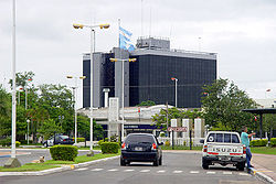
Formosa, in the text of the provincial Constitution: Province of Formosa, is one of the twenty-three provinces of the Argentine Republic. In turn, it is one of the twenty-four self-governing states that make up the country and one of the twenty-four national legislative electoral districts. Its capital and most populous city is Formosa. It is located in the northeast of the country, in the Norte Grande Argentino region, bordered to the north by the Pilcomayo River that separates it from Paraguay, to the east by the Paraguay River that separates it again from Paraguay, to the south by the Bermejo and Teuco that separate it from Chaco, and to the west with Salta, through a meridian.
With 530,162 hab. in 2010 it is the eighth least populated province —ahead of Chubut, San Luis, Catamarca, La Rioja, La Pampa, Santa Cruz and Tierra del Fuego, the least populated— and with 72,066 km², the fifth least extensive, ahead of Jujuy, Misiones, Tucumán and Tierra del Fuego, Antarctica and the South Atlantic Islands, the least extensive.
It extends between parallels 22° and 27° south latitude and meridians 57° and 63° west longitude of Greenwich. It is crossed, in its northern zone, by the Tropic of Capricorn that places it in the tropical region of the country. It occupies a large part of the Central Chaco, known until the beginning of the 20th century also by the name of Llanos del Manso.
Inhabited ancestrally by various tribes of Pampid and Amazonian origin, the first European arrived in the territory in 1528. The bellicosity of the natives forced all colonizing attempts to postpone their occupation attempt. After the May Revolution and the Wars of Independence, it remained isolated, only occasionally inhabited by workers who came to its territory in search of wood. The War of the Triple Alliance, in which Paraguay was attacked by Brazil, Argentina and Uruguay, aroused the interest of the government of the Argentine Republic to occupy it around the 1870s.
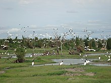
Framed in a rich natural environment where jungles in galleries, tropical forests and savannahs are combined, habitat for a large number of animal species, it is one of the provinces with the greatest biodiversity.
According to data provided by INDEC from the Permanent Household Survey, in 2010 the city of Formosa had the second lowest unemployment rate in the country with 2.2%.
Toponymy
Formosa derives from the old Spanish fermosa, which means "beautiful" and would have been given by the Spanish conquerors, who over time began to name that area as Vuelta Fermosa.
The island of Taiwan, also known as Formosa (Ilha Formosa), was named after Portuguese explorers. This island is located at the antipodes of the Province of Formosa.
History
The current territory of the Province was inhabited in the 16th century, from east to west, by the following ethnic groups: the so-called Payaguás by the Guarani, Qom'leks, Pilagás, Nivaklés and Wichis, these are They added up in small mixed populations.
These ethnic groups were pejoratively called Guaycurú by the Avá (or Guarani) who made war against them and tried to expand along the Pilcomayo and Bermejo rivers.
The first Europeans known to have set foot on the land of Formosa today were the members of the expeditions in 1528, it is considered that it is from that time that the area received the archaic Spanish name of Formosa (Beautiful) in memory of a turn of the Paraguay river with beautiful landscape, excellent fishing and hunting and very good land for camping and anchoring ships.
The existence of native populations made the stable settlement of European or Creole populations impossible until almost the end of the XIX century.
An example of the almost impossibility of the conquest of this territory by whites occurred in the 16th century, when the foundation of Concepción de Buena Esperanza failed, a royalist city that was located on the southern bank of the Bermejo river, therefore outside the current territory of Formosa, although with an area of influence that covered a large part of the current province of Formosa.
Towards the middle of the XVIII century, in the area of the Abipone Indians, the Jesuit missionaries, founding the mission of Santo Rosario and San Carlos or mission of Timbó, on November 24, 1763, by the Jesuit priest Martín Dobrizhoffer. It was under the Government of Paraguay and the bishopric of Asunción. Its name was imposed by the governor of Paraguay José Martínez Fontes ―in devotion to the Virgin Mary and in honor of King Carlos III―. Life in this mission was very difficult, because the poverty of the place was compounded by the shocks caused by the continuous incursions of Tobas and Mocovíes. The soldiers were few to face the riots and attacks.
Around 1776, there was news that 350 Abipones had become Christians, baptized their children, and worked on the farms. But the work of the missionaries was paralyzed after the expulsion of the Jesuits in 1767.
Litigation with Paraguay and Bolivia
From 1811 to 1865 the territory of the current province of Formosa was in dispute between Argentina and Paraguay, neither of the two states being able to enforce their sovereignty.
After 1870 Paraguay abandoned its claims to the south of the Pilcomayo River and in 1872 Argentina did the same to the north of that river (that is, it abandoned its claims to the Chaco Boreal).[citation required]
Bolivia, for its part, renounced its claims to the Central Chaco (which on its maps was known as Llanos del Manzo or Llanuras del Manso), in 1829, in favor of Argentina.[ citation required]
In 1865 Argentina signed the secret Treaty of the Triple Alliance with Brazil and Uruguay. By this treaty the current province of Formosa and an extensive portion of Chaco to the north of it up to Bahía Negra should remain in Argentine territory at the end of the war. Bolivia, on the other hand, held sovereignty over part of the Chaco Boreal, events that would later trigger the Chaco War against Paraguay in 1932.
General Emilio Miter occupied Villa Occidental in October 1869, facing the city of Asunción.
Government of Chaco
On January 31, 1872, a decree by President Domingo Faustino Sarmiento created the Governorate of the Chaco Territories, a region north of the Salado River and all of the Boreal Chaco that is currently the jurisdiction of the Republic of Paraguay. By the same decree, the capital of that government was created: Villa Occidental (then called Villa Argentina, currently in Paraguayan territory under the name of Villa Hayes).
The first governor of the territories of the Gran Chaco was appointed, General Julio de Vedia, commander of the Argentine forces stationed in Asunción, Paraguay.
In October of the same year, the National Congress ratified the decree of the P.E.N. through the sanction of Law No. 576. The limits of the territory were not mentioned in the decree or in the law, extending approximately from the Salado River to the south, to the Verde River to the north. To the west, they were not defined.
The boundary treaty signed between Argentina and Paraguay on February 3, 1876 established, "The Chaco Territory up to the main channel of the Pilcomayo River (...) belongs to the domain of the Argentine Republic the Isla del Atajo or Cerrito». Argentina recognized the territories to the north of the Río Verde up to Bahía Negra as Paraguayan, without taking into account that these latter territories were also claimed by Bolivia, and submitted the territory between the Pilcomayo, Paraguay and Verde rivers to arbitration by President Rutheford Hayes of the United States, who ruled two years later against the Argentine claims. Villa Occidental was then evacuated and turned over to Paraguay.
Installing the capital of the National Territory of the Gran Chaco from September 1876 to January 1877, in the barracks on Isla del Cerrito that was returned by the Brazilian government that kept the island occupied.
On April 8, 1879, with Luis Jorge Fontana as acting Governor, the city of Formosa was founded, in the place called Vuelta Formosa, which became the capital of the Argentine Gran Chaco until the division of the territory in 1884.
Between 1883 and 1884 the original populations were subjected.
National Territory of Formosa
In 1884, Law 1532 of National Territories was enacted, creating three federal jurisdictions in the north and six in the south. In the north the national territories of Chaco, Formosa (in previous projects called Territorio del Bermejo) and Misiones were created and in the south La Pampa, Santa Cruz, Neuquén, Río Negro, Chubut and Tierra del Fuego. In this way Formosa was separated from the Argentine governorate (later province) of Chaco by the new course of the Bermejo river (or Teuco river), to the north new awards rectify the limits of the Pilcomayo river, Paraguay obtaining new territories (between the arm called Confuso and the so-called Porteño) as well as most of the Patiño estuaries.
Since November 1884, General Ignacio Fotheringham was appointed Governor of the National Territory of Formosa. His rule lasted from 1884 to 1887.
From 1885 the territory began to have a permanent Creole and white population.
The construction of the railway in its first stage between 1908 and 1917; and in the second until 1930 it facilitated the exploitation of raw materials and the increase of the population.
Provincialization
On June 15, 1955, during the presidency of General Juan Domingo Perón, by law 14,408 Formosa became a province. On June 28, 1955 (after the Plaza de Mayo massacre, the first coup attempt, Perón promulgated Law 14,408), but the September 1955 coup occurred and a new pilgrimage and the province, despite After having the law, it only had its provincial Constitution in 1957 and its first constitutional government in 1958.
Other historical events
- 1763: First population attempt on the territory, in what is now Herradura[chuckles]required]
- 1879: Fundación de la villa Formosa.
- 1883: Formosa municipality is created.
- 1885: By decree of 19 July, the territory is divided into four regions.
- 1885: The sugar mill of Mayer and Bonaccio is installed.
- 1899: The village of Clorinda is founded.
- 1901: The Franciscans begin to develop the villages of Tacaaglé and Laishí as a reduction of Aboriginal people.
- 1904: By decree of 19 May, the National Territory of Formosa is divided into twelve departments.
- 1905: The first factory of tanino, Alberto Bracht, is installed.
- 1905-1908: Enrique Faure leads the construction of the railway line Formosa-Embarcación (Salta).
- 1915: By National Decree of 20 October, the nine departments of the National Formosa Territory are established.
- 1919: The Massacre of Fortin Yunkah happens: 15 dead.
- 1930: The railway line between Lomitas (Formosa) and Embarcación (Salta) is opened.
- 1940: The trace of the Barilari line sets the limit with the province of Salta: Formosa loses about 1000 square kilometers.
- 1946: Rolando de Hertelendy is appointed governor of the territory by the national authorities. He becomes the first ruler of the province.
- 1947: Rincon Bomb Massacre.
- 1955: By law 14.408 Formosa is elevated to the province category.
- 1957: The provincial Constitution is sanctioned.
- 1958: On 7 February, LRA 8 Radio Nacional Formosa made its first broadcast, being a milestone for the provincial radio station
- 1958: The first elections are held to elect governor in the province. Luis Gutnisky of the UCRI is elected.
- 1959: Decree 741 establishes the provincial shield.
- 1975: Attack on the Monte 29 Infantry Regiment in Formosa City.
- 1978: Begins to transmit Formosa Channel 11.
- 1983: The floods in Formosa, Pirané, Clorinda and Herradura cause considerable damage and losses.
- 1986: serious damage to floods in the city of Pirané.
- 1988: The hymn March to Formosa becomes the official anthem of the province.
- 1988: Law 23.631 creates the National University of Formosa, based in the provincial capital.
- 1990: Opening of the San Ignacio de Loyola International Bridge, between Clorinda and Asunción del Paraguay.
- 1991: First reform of the Constitution of the province.
- 1991: The provincial flag is approved.
- 1992: Serious damage to the floods in the city of Clorinda.
- 2003: A new modification of the constitution of the province establishes the indefinite re-election of the governor and President Néstor Kirchner signs the Historical Reparation Act.
Provincial symbols
Hymn March to Formosa
The Hymn-March to Formosa (also called March-Hymn to Formosa ) is the official song of the province of Formosa.
It was composed in 1954 by Armando de Vita y Lacerra; the music was added by Major Víctor Rival, director of the music band of the Monte 29 Infantry Regiment of Formosa.
History
In 1954, a social organization from Formosa commissioned the poet Armando de Vita y Lacerra to create a hymn that represents the Formoseños. The writer embodied his ideas in a three-stanza poem. The music was entrusted to Major Víctor Rival, director of the music band of the Monte 29 Infantry Regiment of Formosa; who immediately initiated his efforts in conjunction with the Polyphonic Choir of the Province.
Finally, by 1955, the hymn was finished; and on April 8 of that year (Formosa Foundation Day) it is sung for the first time in an official act.
But it would take several years for the provincial government to recognize the march in 1964 and award a medal to its authors.
On July 21, 1988, the administration of Governor Vicente Joga published Decree no. all official acts together with the Argentine National Anthem».
Shield
The coat of arms of the province of Formosa was officially created on June 29, 1958.
- History
By law no. 1, on June 2, 1958, the creation of a Mixed Commission was established that, through a contest, selects the best preliminary design projects for the future Coat of Arms of the Province; and then refer them to the Executive Power.
The contest was awarded to Mr. Juan Enrique Bejarano, and by Law No. 69, of June 29, promulgated by Decree No. 741/59, the following was sanctioned:
Article 1.o. Delay the official shield of Formosa Province as a result of the contest authorized by article 28 of Act No. 1.Article 2. This shield has the following shape and attributes: irregular polygonal field of eight sides divided into two barracks: the superior with blue and the lower white color; under the dividing line, at the white barracks, two vigorous hands intertwined, symbolizing the union of all their children. In the blue barracks a cotton cocoon symbol of a productive and industrial future, crowned by nine stars symmetrically arranged, representing the provincial departments. At the top a rising sun with beams in gear arrangement symbolizing the new province and at the bottom two branches of laurel.
Article 4. The original of this shield will be preserved as a pattern in the General Archive of the Province with the law of its creation to the back and the signature of the author and the legislators who intervened in his sanction.
The Department of Provincial Historical Heritage clarified the interpretation that the Selection Commission made in relation to the stars. According to the original drawing, they did not have five points but four and the same number of stripes each, which the author possibly interpreted as reflections, which is why they were recorded in the impressions of the Shield as they appear in the author's original. He did not define the colors of the laurels, nor of the forearms and hands, which were later printed.
- Features
It is in the shape of an eight-sided symmetrical irregular polygon with a gold fillet around the edge. The upper part is light blue, while the lower part is white. In the lower part two clasped hands and in the upper part a cotton cocoon surrounded by nine central arc-shaped stars. A rising sun in the shape of a golden industrial gear at the top and two laurel branches on each side at the bottom.
Flag
The flag of the Province of Formosa is one of the official symbols of it, one of the 23 administrative divisions of Argentina. Its motive is fundamentally inspired by the location of the Province in the Southern Cone.
- Fundament
The basic proposal of this design arises from the location of the Province of Formosa in the Southern Cone and the leading role that fits it within the framework of regional and continental integration. Taking this as the only theme of the proposal given its geopolitical importance and ensures its projection and permanence over time.
The aim is to reflect the presence of Formosa in the heart of the continent, emphasizing the integration project through its extensive border as a historical variant.
The cloth divided into three fields represents the Southern Cone embraced by the two oceans, expressed in the light blue and white colors of the National Flag.
It is noteworthy for a better understanding of the geographical location of the Province in the country, as it is crossed by the Tropic of Capricorn. This has been marked by a wreath of laurels that crosses the entire cloth lengthwise. The institutional structure of the province synthesizes in nine stars arranged in a circle at the height of the Tropic, components already present in the Provincial Shield.
- History
The idea of creating a provincial flag in Formosa arose within the Constituent Convention, convened in 1991, in order to reform the provincial Constitution of 1957.
Geography
It integrates the geographical area known as the Chaco Region. It has a uniform relief with a gentle northwest-southeast inclination, the rivers and streams, although sometimes wandering and forming estuaries, also follow the northwest-southeast direction; the almost exclusive biome is that of the Chaco forest.
Climate and vegetation
The provincial climate is subtropical. To the east, the rains are uniform throughout the year, reaching the banks of the Paraguay River to exceed 1,200 mm per year. There, the local climate type is semi-tropical semi-steppe, according to the Papadakis scale, which takes minimum temperatures into account. According to the Koppen scale, Formosa's climate is divided into a CFA (subtropical without dry season) mesothermal climate in its eastern sector, and a CWA (subtropical with dry winter) in its western section. A small portion of the extreme northeast that coincides with the departments of Pilcomayo and Pilagás has an AW climate, that is, tropical savannah, which occurs in localities such as Clorinda (adjacent to Asunción) with average annual temperatures of 24° and no month below the mean of 18°. This is the only place with a megathermal climate in Argentina, based on the climate graph of the Paraguayan capital.
The more to the west the localities of the territory have a clearer winter dry season, with rains in the warm season, which on the border with Salta add up to only 600 mm per year. There, the local climate type is continental semitropical.
During the summer, which is long and hot in the province, temperatures rise to more than 45 °C throughout the territory, while in winter, on some days it usually drops to 6 °C due to wind action pampero.
The north wind is another of the distinctive features of the region, which blows strongly from the end of August to the beginning of April; It is a hot and humid wind, and it affects the population causing changes in mood.
Uneven humidity determines differences in vegetation. Near the rivers the gallery jungle develops, with specimens such as the carob tree, palo amarillo and palo santo. To the west appears the Chaco forest where the red quebracho and white quebracho grow, the lapacho, the urunday, the guayaybí, the thorn crown, the guaraniná, the palo lance, the ibirá-pitá, the urunday, the palo blanco, the timbó and the Caranday and Pindo palms.
On the border with the province of Salta is the area known as El Impenetrable.
Water resources
Allochthonous Courses
- Paraguay River.
- Bermejo River.
- Rio Pilcomayo.
The normal inclination of the land influences the runoff of the Pilcomayo, Bermejo or Teuco rivers and other streams that run parallel to them in a West-East direction.
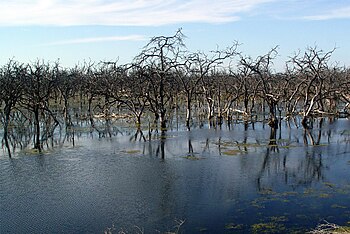
The Pilcomayo River obtains its flow from snowmelt on the Bolivian peaks and summer rains. Its channel is very changeable and its course branches as a result of the clogging of its channel due to the large amount of sediments it transports. Upon entering Formosa territory, Bañado la Estrella originates.
The Bermejo River also rises in the Bolivian Andes and flows to the Paraguay River, which as it passes through Argentine territory presents a wide flow that allows navigation for smaller draft vessels.
Indigenous courses
- Riacho Porteño.
- Riacho Formosa.
- Riacho He He.
- Riacho Monte Lindo Grande.
- Riacho Monte Lindo Chico.
- Riacho Pilagá.
- Riacho Salado
- Riacho Tatú Piré.
- Riacho Timbó Porá.
- Riacho Malvinas.
- Riacho Cortapik.
- Black Riacho.
- Riacho San Hilario.
Limits
Formosa has 3 large rivers as natural boundaries.
- To the north, the Rio Pilcomayo separates it from the departments Boquerón, President Hayes and Central of the Republic of Paraguay.
- To the east, the Paraguay River is the limit with the Department of Rheembucus of the Republic of Paraguay.
- To the south, the Bermejo River is the border with the Chaco Province.
Finally to the west the Barilari line, coincident with the meridian 60º 20' 17' Or, it separates Formosa from the Province of Salta.
Ecology
The Province of Formosa is located within the subdivision of the Gran Chaco known as the Central Chaco.
Protected Areas
Parks and Reserves
- Río Pilcomayo National Park.
- Natural Formosa Reserve.
- Provincial Natural Reserve Bañado la Estrella.
- Reserva de Biosfera Laguna Oca del río Paraguay.
- Biosphere Reserve Riacho Teuquito.
Animal shelters
- Guaycolec Wild Animals Station
Botanical Gardens
- Lucas Tortorelli Botanical Garden.
Flora
The type of vegetation varies throughout the territory.
In the east, savannahs and grasslands are developed with Caranday palm groves and gallery forests on the banks of watercourses.
Representative species of the flora of the eastern province:
- Copernicia alba.
- Pindo
- Timbó Colorado
- White Timbó (Albizia inundata)
- Pitá will go
- Guayacán (Libidibia paraguariensis).
- Palo Cruz (Tabebuia nodosa)
- Tatané (Chloroleucon tenuiflorum).
- Urunday (Astronium balansae).
- Ñangapirí
- Crown Spine (Gleditsia amorphoides)
- Ambay
- Wow.
- Ceibo (Erythrina crista-galli)
- Ñandypá (American Genipa)
- Sauce Criollo (Salix humboldtiana)
- Spine (Vachellia caven)
- Ñandubay (Prosopis affinis)
- Mbocayá (Acrocomia aculeata)
The provincial center is characterized by large extensions of closed or impenetrable forest.
Representative species of the flora of the provincial center:
- Colorful brittle
- Bloody white male
- White gum.
- Holy cow
- Palo drunk
- Vinal
- Black Algarrobo
- Guayacán (Libidibia paraguariensis).
- Mistol (Ziziphus mistol)
- White Algarrobo (Prosopis alba)
- Carandilla (Trithrinax schizophylla)
To the west, the vegetation includes xerophytic formations.
Representative species of the flora of the western province:
- Palo Borracho
- Cardón Moro (Stetsonia coryne)
- Quimil (Opuntia quimilo)
- Tuna (Opuntia elata)
- Guayacán (Libidibia paraguariensis).
- Mistol (Ziziphus mistol)
- White Algarrobo (Prosopis alba)
Wildlife
The provincial fauna is very rich and diverse. There are more than 450 species of birds, more than 30 species of mammals and a great variety of reptiles and fish.
The most striking birds:
- Tucan
- Jabiru
- Surucuá
- Rhea
- Urraca Morada (Cyanocorax cyanomelas)
- Garza Blanca
- Monjita Blanca (Xolmis irupero)
- Charlatan (Dolichonyx oryzivorus)
- Yetapá de necklace (Alectrurus risora)
- Charata (Ortalis canicollis)
- Chajá (Chauna torquata)
- Pato Cutirí (Amazonetta brasiliensis)
- Crespín (Tapera naevia)
- Tingazú (Piaya cayana)
- Ipacaá (Aramides ypecaha)
- Tuyuyo (American Mycteria)
- American Storm (Maguari Cyconia)
- Rosada spatula (Platalea ajaja)
- Bandurria Mora (Theristicus fallulescens)
- Chiflon (Syrigma sibilatrix)
- Ñacurutú (Bubo virginianus)
- Aguilucho Pampa (Busarellus nigricollis)
- Taguató (Rupornis magnirostris)
- Speaker parrot (Aestiva area)
- Guaycurú (Herpetotheres cachinnans)
- Yapu (Psarocolius decumanus)
- Matico (Icterus croconotus)
- Federal (Amblyramphus holosericeus)
The most striking mammals are:
- Aguará Guazú (Chrysocyon brachyurus)
- Tatú wagon
- Yaguareté
- Tapir
- Ocelote (Leopardus pardalis)
- Giant ant (Myrmecophaga tridactyla)
- Honey Bear (Tamandua tetradactyla)
- Puma (Puma concolor)
- Zorro (Cerdocyon Yous)
- Pecari (Pecari tajacu)
- Coatí (Nasua nasua)
- Aguará Popé (Procyon cancrivorus)
- Alouatta caraya
- Carpincho
Political organization
The provincial Constitution was approved in 1957 and reformed in 1991 and 2003. The provincial state is organized in the republican manner.
The executive power is exercised by a governor, elected for a period of 4 years, and who can be re-elected indefinitely, according to the constitutional reform of 2003.
The legislative power corresponds to a unicameral Legislature:
- Chamber of Deputies: 30 seats
The judicial power is exercised by the Provincial Supreme Court of Justice.
Administrative division
The province is divided into 9 departments, which in turn are divided into cadastral districts, and include local government areas, divided into 27 municipalities, 10 development commissions and 18 provincial neighborhood councils.
For a complete list of departments see Annex: Departments of the Province of Formosa. For a complete list of municipalities, development commissions and neighborhood boards see Annex: Municipalities, development commissions and neighborhood boards of Formosa. For information on the municipal organization of the province, see: Municipal Organization of Formosa.
Greater Argentine North Region
The Interprovincial Treaty for the creation of the Northern Region of Argentina, was signed in the city of Salta on April 9, 1999 between the provinces of Catamarca, Corrientes, Chaco, Formosa, Jujuy, Misiones, Tucumán, Salta and Santiago del Estero.
«The primary purpose of this treaty is the creation of the Norte Grande Region and the concretion of the integration of the provinces of the NOA and the NEA, in order to achieve in reality an effective system of consensus and joint action between the states parties".
The Norte Grande Regional Council is the highest regional government entity, made up of the Assembly of Governors, the Executive Board and the Coordinating Committee. The latter is made up of a representative from the NOA and another from the NEA, both of whom are also members of the Executive Board. The Interministerial Executive Commission for Regional Integration coordinates the integration process based on the directives of the aforementioned higher bodies.
Population
- Census 1991: 398 413 inhabitants (Indec, 1991) (urban population:270 061 inhabitants (Indec, 1991) (rural population: 128 352 inhabitants (Indec, 1991).
- Census 2001: 485 700 inhabitants (Indec, 2001) (urban population: 375 153 (Indec, 2001), rural population: 110 547 (Indec, 2001).
- National census 2010: 527 895 inhabitants (Indec, 2010) (urban population:428 703 inhabitants (Indec, 2010), rural population:101 459 inhabitants (Indec, 2010).
Historical evolution of its population:
- 1895: 4829
- 1914: 19 281 hab.
- 1947: 113 790.
- 1960: 178 526 hab.
- 1970: 234 075 hab.
- 1980: 295 887 hab.
- 1991: 398 413 hab.
- 2001: 489 276 hab.
- 2010: 527 895 hab.
| Graphic of demographic evolution of Formosa Province between 1895 and 2010 |
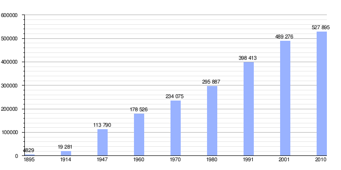 |
Source of National Censuses of INDEC |
According to the 2010 Census data, the provincial population amounted to a total of 527,895 inhabitants. The population is unevenly distributed. The bulk of the inhabitants are concentrated in the eastern province, on the banks of the Paraguay River, in the surroundings of the cities of Formosa and Clorinda, which are the most populated. The population density decreases from east to west, although it picks up slightly in the far west, in the departments bordering the province of Salta.
Two elements intervene mainly in the population of the province, the native and the European. The first, indigenous, constituted the entire population until the end of the 19th century, when the white man began to explore the region. The natives resisted tenaciously, which prompted the Argentine army to launch a series of military operations to subdue them. The consequences of this campaign are still noticeable today: an excessive concentration of land in the hands of whites, while the original population still demands that they be granted territories that they have inhabited since ancient times. With the founding of Villa Formosa and under the protection of the Avellaneda Law, contingents of Italian and Austrian settlers arrived in the region, occupying plots of land in the vicinity of the newly founded town. Around the 1920s and 1930s, the activation of the Belgrano Railroad project led to the arrival of small contingents from Central and Eastern Europe, who worked as construction workers and settled along the railway line.. In the area of Laguna Blanca and El Colorado there are small groups of German descent. The Chaco War and the social, political and economic crises in Paraguay caused a migratory flood of Paraguayan settlers, who settled in areas that were outside the possession of land holders protected by colonization laws, such as areas close to Clorinda, where they dedicated themselves to the cotton activity, who strongly impregnated the culture of the man from eastern Formosa.
In the west of the province, on the other hand, the advance of the Salteños, who were looking for new lands for grazing cattle, originated a strong presence in the populations of that area of the province, visible in their customs and traditions. In Ingeniero Juárez, the presence of Arab immigrants of Syrian-Lebanese origin is noticeable.
Most of the population speaks Spanish, but numerous native communities still preserve their ancestral languages, such as Qom, Pilagá or Chiriguano. Much of the provincial geography preserves autochthonous place names.
Main cities
The main urban centers of the province, whose populations exceed 10,000 inhabitants, according to the 2010 Census data, are:
- Formosa (222 226 hectares), capital of the province and its administrative and economic center. Active river port on the banks of the Paraguay River, with import and export trade. It has museums, theatres, public and private universities, higher institutes, sports stadiums, large squares, large avenues and tree-lined walks.
- Clorinda (52 837 hectares), very close to the Paraguayan capital, Asunción. Keeps an active trade with this one. It is a subsection of the National University of the Northeast and the National University of Formosa. He has tertiary institutes.
- Pirané (20 335 inhabitants), important agricultural center.
- The Colorado (14 228 hectares) nicknamed the Pearl of the South. It's the fourth largest city in town.
- Ingeniero Juárez (12 798 hectares). It's a communications knot from the provincial west.
- The Lomites (12 399 hectares) is one of the most commercially prosperous cities in the western province. It hosts a hotel and an airport. A few km away you will find the Star Bañado.
Towns with more than 5,000 inhabitants:
- Ibarreta (9 429 inhabitants), provincial capital of the carnival.
- Laguna Blanca (7 411 hectares), headquarters of museums, institutes and the National Pomelo Festival.
- Commander Fontana (6,615 inhabitants).
- Palo Santo (6 379 hectares), wood center.
Economy
The economy of Formosa is the smallest scale and most important in the country, with a Gross Geographic Product (GDP) that represents around 0.48% of the national GDP. The province's GDP is made up of 13% of the primary sector, highlighting the cultivation of cotton with 1.5 million ha18% for the secondary and 69% for the tertiary. Within the latter, the high participation of the public sector stands out, representing 45% of it. The main source of resources is the provincial State itself, which is 95% financed by the National State, through federal co-participation and ATN, collections from other provinces.
The private economy is essentially primary, being based on cattle raising and agriculture.
- Crop: the crops of cotton, rice, fruits (bananas, ananas, grapefruit, melon, mamon, guayabas, mangos) and vegetables (zapallo, cassava, pepper and tomato), also soja corn sugar cane, cinnamon, ginger, nutmeg and to less extent cocoa, coffee, coco and vanilla.
- Forest exploitation: the use of forests had a great development since the beginning of the 20th century. Tanin production was very high. Native species (algarrobo) are currently used. Furniture and parts of furniture (such as panels for coating), sawn wood and charcoal are exported. This activity was diminished in the 1990s.
- Livestock: is represented by more than one million cattle, especially by British races (Aberdeen Angus, Shorthorn and Heresford) and Zebu (Brahman and Nelore). Goats and buffaloes are also raised.
- Mining: Oil exploitation began in 1984 in Palmar Largo but in small quantity. Currently, the joint company REFSA (Resources y Energía de Formosa S.A.) is responsible for most operations.
- Industry: the production of tannins is highlighted, to produce adhesives, additives and tanners. The textile sector is also very important (disassembled cotton, leather and wild skin production). In addition, the food industry stands out, finding itself in the city of Formosa an important bottler of a recognized gasket that is distributed to the entire NEA. There is an industrial promotion park. In recent years, the chemical and pharmaceutical industry, with the development of creams and medicines for tropical and subtropical diseases, has been growing.
- Tourism: While tourism is not the strongest bet, in recent decades several cities have been declared of interest, such as Las Lomitas or Herradura. Currently, new companies add hotels, casinos and tourist infrastructure, at various points in the province.
- Agronomy: the province is currently experiencing growth in the living area that covers the production and marketing of plants of different kinds to multiple parts of the country and abroad. In Formosa there is also the largest producer and marketer of tropical and subtropical palm trees in the national territory. [1]
Tourism
Formosa is a young province that has developed rapidly in its various traditional areas. His leadership determined through the search for new areas, a new niche capable of generating genuine income for the province, tourism. Thus, the former Tourism Directorate was elevated in rank, turning it into a Ministry with its corresponding budget.
This portfolio begins to work on the vertebral aspect, preparing the documentation to be presented to the World Bank, in order to achieve a Strategic Tourism Plan for the Province. The same, approved by the authorities of the monetary entity, began to be developed from the year 2005. In parallel, from the beginning of the year 2004 and with great dynamics, it was presented to the Province in four circuits, with a mega event as a Cover letter for each circuit: The Corvina Festival and the Meeting of Original Peoples of America in the Eastern Circuit; The Grapefruit Festival and other events such as the Pre - Cosquín de Pirané and Clorinda in the North Circuit; or the Oil Festival in the Western Circuit; thus linking productive and cultural events to the wonderful natural settings, such as Herradura, Formosa Capital, Río Pilcomayo National Park, Bañado la Estrella and the Central West, trying to outline icons and tourist products, assembled in the region, but with special characteristics that begin to place Formosa as a new destination in the National Tourist Calendar.
Access
- Air
- International Airport of Formosa, Formosa
- By land
- RN11 from Buenos Aires, Resistencia, Corrientes, Rosario to the city of Formosa, Clorinda, Asunción (Paraguay).
- RN95 from the Province of Chaco to El Colorado, Pirané.
- RN81 from Salta Province to Ingeniero Juárez.
- Formosa Bus Terminal Station. There are also terminal stations in Clorinda, Laguna Blanca, Pirané, Las Lomitas, El Colorado e Ingeniero Juárez.
- By water
- Port of Formosa.
- Puerto Pilcomayo.
Accommodations
- In Formosa: 1 (5*), 3 (4*), 4 (3*), 4 (2*), 1 (Apart).
- In Clorinda: 1 (3*), 3 (2*).
- Other accommodations in: Villa General Güemes, Ibarreta, Ingeniero Juárez, Laguna Blanca, Las Lomitas, Palo Santo, Pirané, Herradura, General Manuel Belgrano, Estanislao del Campo.
Distances
From the City of Formosa to:
- Buenos Aires: 1181 km
- Córdoba: 1037 km
- Resistance: 169 km
- Current: 186 km
Places to visit
- Río Pilcomayo National Park: its 47,000 hectares protect an area where estuaries predominate, bathed and savannahs of white palm or caranday.
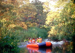
- Bañado la Estrella - Las Lomitas: of hundreds of thousands of hectares, is an important family reserve. It can be covered in piragua.
- Natural Formosa Reserve: typical semi-desert area of the western shawl ecosystem.
- Reserva de Biosfera Laguna Oca del río Paraguay - City of Formosa
- Riacho Teuquito Biosphere Reserve
- Juan Pablo Duffard Regional Historical Museum - City of Formosa
- Police Museum - City of Formosa
- Casa de Artesanías Aborígenes - City of Formosa
- Franciscan Missions - Laishí
- Franciscan Missions - Tacaaglé Mission
- Art Museum Qomp Toba - City of Formosa
- Natural History Museum - Laguna Blanca
- San Francisco de Laishí Historic Museum - Laishí
- Pueblo Museum - Pirané
- Eco Museum - El Colorado
- Municipal Historical Museum - Riacho He-Hé
- Dr's house. Esteban L. Maradona - Stanislao del Campo
- Natural monument Yaguareté
- City of Formosa
- Clorinda
- Laguna Blanca
- Laguna Yema
- The Lomites
- Pirane
- The Colorado
- Herradura (Formosa)
- Costanera de Formosa
Non-traditional tourism
- Sport fishing: the majesty of the three large rivers whose waters surround the province of Formosa, turn this territory into a magnetic attraction for delegations of amateur fishermen who arrive at their coasts in search of coveted species of sporting value. Surubí, manguruyúes, corvinas, gilded, peacocks, the fisherman's paradise would seem to be found in the north end of Argentina. Both the Paraguay River, and the Bermejo and the Pilcomayo, run through Formosa, being constituted in reservoirs of giant fish where the practice of the sport of the pique is graced, also by the tranquility and silence characteristic of this border area. Capture of specimens of enormous dimensions, fish of specimens characterized by the delicacy of their meats, the satisfactions of the fisherman will find their maximum point in the formosic waters. The recommended areas are located in the Paraguay River and its tributaries: Colonia Dalmacia, Herradura, Colonia Aquino, Arroyo Ramírez, Boca del río Bermejo, Villa Emilia, Boca del riacho Pilagá. Each fisherman can extract a maximum of ten pieces daily, although this can vary according to the species and season. A sports license is also required which is granted by the Directorate of Fauna of the Province. No exceptions, throughout the year, and at each point in the region, the influx of fishers from all of South America is the coast of Formosa. Habitat of a varied and numerous ictícola fauna, and possessor of an infrastructure perfected with the best services for the tourist lover of fishing, this Argentine province is an undesirable site when choosing a fishery of excellence.
- Active tourism: from the estancias there are excursions on foot, in canoe, piragua or on horseback to observe the fauna.
- Ecotourism: birdwatching, photographic safaris and river sailing.
- Historical tourism
- Gastronomic tourism: although it is not very driven, in the province there is one of the largest varieties of food products for tourist tasting, such as typical fruit sweets.
Typical products
- Alfarería, cestería, carvings in holy stick wood and fabrics of yarn or wool with which fajas, networks and bags are made to hang called yicas, at the Institute of Indigenous Communities of Formosa.
- Typical tasting products of the area, such as Paraguayan soup or mammon sweets, banana, guava; among others.
Sports
Football
The most important soccer clubs are:
- Club Sportivo Patria (Formosa)
- Club Sportivo General San Martín (Formosa)
- Club Sol de América (Formosa)
- Social, Cultural and Sports Club June 13 (Pirané)
Outstanding footballers
- Hugo Ibarra, champion of 1 Intercontinental Cup, 4 Copa Libertadores de América, 2 Copa Sudamericana and 7 local championships.
- Maximiliano Lovera, champion of 2 national cups and a local championship.
- Luis Cristaldo, champion of 9 local championships.
- Ramón Ignacio Fernández, champion of 6 local championships.
- Aldo Paredes, champion of 1 South American Cup, 1 Mercosur Cup,1 local championship.
- Ramón Bóveda, champion of 3 local championships.
- Gervasio Núñez
- Raúl Bobadilla
Basketball
In 2019, the Formosa team would win the Argentine Basketball Championship for the first time in its history.
Boxing
Notable boxers
- Marcela Acuña, world champion of feather weight and supergallo weight.
Volleyball
Outstanding volleyball players
- Ezekiel Olympic medalist palaces with the Argentina team (Tokio 2020)
- Emilce Sosa
- Leandro Sotelo
Olympians
Women's Volleyball
- Emilce Sosa - Rio de Janeiro 2016 Olympic Games
Men's Volleyball
- Ezequiel Palacios - Rio de Janeiro 2016 Olympic Games
Modern pentathlon
- Sergio Alí Villamayor. First Argentine to achieve a presea in discipline in the history of the Pan American Games.
Transportation
National routes
 National Route 11
  National Route 81
  National Route 86
  National Route 95
Provincial Routes
Primary Network
 Provincial Route 1
 Provincial Route 2
 Provincial Route 3
 Provincial Route 7
 Provincial Route 9
 Provincial Route 16
 Provincial Route 23
 Provincial Route 24
 Provincial Route 26
 Provincial Route 28
 Provincial Route 37
 Provincial Route 39
Secondary Network
 Provincial Route 4
 Provincial Route 5
 Provincial Route 6
 Provincial Route 8
 Provincial Route 14
 Provincial Route 20
 Provincial Route 21
 Provincial Route 22
 Provincial Route 25
 Provincial Route 27
 Provincial Route 29
 Provincial Route 32
 Provincial Route 33
Airports
- International Airport of Formosa
River ports
- Port of Formosa
- Puerto Pilcomayo
- Colonia Cano
Contenido relacionado
Province of Heredia
Lubumbashi
Aldeadávila de la Ribera
Arakawa River
General Mosconi (Salta)


