Florida Department
Florida is one of the nineteen departments that make up the Oriental Republic of Uruguay. Its capital is the homonymous Florida.
It is located in the center-south of the country, bordered to the north by Durazno, to the northeast by Treinta y Tres, to the east by Lavalleja, to the south by Canelones, and to the west by San José and Flores. Its total area is 10,417 km², and it has a population of 67,048 inhabitants according to the 2011 census.
History
The department of Florida was created by law on July 10, 1856, although its first urban location, Fortín del Pintado, dates back to 1760. Due to the fact that the haciendas of the Montevideans were continuously looted, the The Cabildo ordered the construction of a fort called San Juan Bautista de la Frontera (Pintado) for his protection. This gave relative security to the settlers, who decided to place their cattle around the enclosure, giving rise to another settlement near the blade on the Guardia del Pintado. With the passage of time and the increase in population, the first chapel dedicated to Our Lady of Luján was erected, which was donated by María Rosa Falanca and her son, after the death of her husband, the Indian landowner Antonio Díaz.
Around 1805, Benito Lué y Riega, Bishop of Buenos Aires, built a new church at the request of its inhabitants, and in 1809, Viceroy Santiago de Liniers appointed the priest Santiago Figueredo as the new priest of the area. This would favor the creation of a town at the request of the Cabildo de Montevideo, being advised by the attorney Bernardo Suárez. On April 24 of that same year, Figueredo in the company of three spokespersons representing the community declared aloud: "The town of San Fernando de la Florida is erected by His Majesty our beloved monarch.& #34; In this way the eastern town would be born, which would later be the scene of the declaration of national independence. The town was named after Ferdinand VII, King of Spain at the time, and Carlos III's minister, José Moñino, Count of Florida and future first president of the Central Board of Spain and the Indies.
Florida at the height of the independence revolution
After the Eastern Province was invaded and taken over by the Portuguese in 1816, and with Lecor in command, the government distanced itself from Buenos Aires power, creating the new Cisplatina Province. For almost five years the territory was subject to the Lusitanian will, and after the independence of Brazil, the former Banda Oriental would become part of its Empire. It was then that on April 19, 1825, a group of thirty-two armed men led by General Juan Antonio Lavalleja made their way from his exile in Argentina and disembarked on the beach of Agraciada de Soriano.
A provisional government made up of trustees of the Cabildos, is created on June 14, installing its headquarters in the Villa de San Fernando. With the agreement of August 20, the province gets its own Board of Representatives under the supervision of Luis Eduardo Pérez, its first president. At the end of the inaugural session of the Board on August 25, 1825, three basic laws were approved: the Independence, the Union and the Flag Law.
This proposal would be presented at the Preliminary Peace Convention of 1828 in Rio de Janeiro, with the participation of the Argentine and Brazilian governments, and a third party, England. With the approval of the statute, the Cisplatina province would become a free and independent country under the name of Oriental Republic of Uruguay, alluding to its geographical location and by virtue of which it had received the old name of Banda and Oriental Province..
The Piedra Alta, where the declaration of Uruguayan independence took place, can be seen today in the Prado in the city of Florida, on the banks of the Santa Lucía Chico river.
Geography
The geographical situation of the department favors communication with the capital of the country, and serves as a direct crossing between north and south, promoting the internal mobilization of its inhabitants, who travel to Montevideo for labor and/or cultural matters.
Orography
Florida presents a diverse topography — La Plata plain and crystalline peneplain — that includes both mountainous areas, as well as rough and stony areas of Illescas in most of the border with the departments of Lavalleja and Treinta y Tres. It also has humid and rich pastures in Maciel, Sarandí, shores of the Arroyo de la Virgen near 25 de Agosto and Cardal, or, in Río Viejo, surrounding San Ramón. It also has granitic cerrilladas with crowns, fellings and thorn of the cross, on fields of consistent and productive low pastures in Isla Mala and in the contiguous coastal strip of the Santa Lucía Chico stream. The landscape includes the modest mountains of Pintado, San Gabriel and Palermo in the confines of the capital, rough hills, abundant in iron and quartz; fields of sand, as in Talita, or with a thin layer of fertile soil, as in Santa Teresa, Juncal and La Macana. The Cuchilla Grande crosses the department from end to end, originating the southern branch of the Cuchilla Grande del Este, which enters the mountain department.
Hydrography
The department has an important hydrographic network, although none of its water courses are navigable. The lower Grande blade separates the two hydrographic basins of the department, they are the Santa Lucía Grande river (to the south) and the Yi river (to the north). The main tributary of the Santa Lucía Grande basin is the Santa Lucía Chico (which crosses the capital), which in turn receives water from the Talita, Cruz and Pintado streams; the Casupá, Chamizo, Arias and Virgen streams are the remaining tributaries of this basin, pouring their waters directly into the Santa Lucía Grande. The Yi river basin has as tributaries the Illescas, Timote (through which the Molles del Timote and Sauce del Timote flow), Maciel, Mansavillagra, Sarandí, Sauce, del Pescado (through which the Molles del Pescado flows) and the Tala de Castro stream.
Climate
The climate is humid subtropical climate with average annual temperatures between 16 and 19 °C and rainfall of around 1000 mm. The summer is arid and hot, and the winter quite cold, which, added to the abundance of precipitations, gives way to a rich pardera of pastures and grasslands, which favors the economy of the department, based on cattle raising and sheep. Along the same lines, the swelling of rivers and streams due to the frequent rains makes their drainage and navigation difficult, which is why cities like the capital or others with easy access are located mainly on high areas. In the winter of 1991, there were snowfall with accumulation in the axis of route 7, mainly in the area of Alejandro Gallinal (formerly Cerro Colorado), but it is not an isolated or unique event in the history of the department.
Demographics
According to the 2011 census, there were 67,084—32,953 men and 34,095 women—persons and 29,437 households in the department. It is estimated that by 2025, the Florida population will be 75,212. For every 100 women there were a total of 96.6 men.
- Intercensal growth rate: -0.23% (2011)
- Birth rate: 14,53 births/1,000 persons (2004)
- Mortality rate: 10.08 casualties/1,000
- Rural population: 9101 inhabitants. (2011)
- Average age: 33.2 (31.8 men, 34.5 women)
- Per capita income (2005): 5,127,2 Uruguayan pesos
- Life expectancy at birth (2004):
| General: | 76.24 years |
| men: | 72.98 years |
| women: | 79.63 years |
- Florida Population (inhabitants):
- 1860: 12 170
- 1908: 45 406
- 1963: 63 987
- 1975: 67 129
- 1985: 66 474
- 1996: 66 503
- 2004: 68 181
- 2011: 67 048
Economy
With a more established agricultural tradition than in other merely cattle-raising departments, the soils do not favor extensive production as those of the coast do, or intensive, such is the case of neighboring Canelones. However, Florida is in the first position regarding the departments that use fertilizers. The main crops are wheat, oats, corn, flax and sunflower. The farm is also considered one of its main virtues. The department contributes 40% of the national dairy production. There is an iron ore deposit on the slopes of the Valentines stream, to the northeast of the capital, in whose reserves some 19 million tons are estimated with a 38% metallic content; another minor source is found in the fields of Castro, where, in addition to iron, feldspars, quartz and granite are obtained.
Poultry farming is practiced with less intensity, and since 1964 it has had its own School aimed at students who have completed basic secondary studies and are preparing to study for a baccalaureate in this specialty.
Education
The department of Florida does not offer great options for higher education, so most high school graduates move to Montevideo to begin their university studies. Among the reserved educational offers, the vast majority of which are in the departmental capital, those for teacher training and those for teaching and learning trades stand out. In other words, we can find the:
- Florida Institute of Training
- Centre Regional Teachers Centre (CERP)
- University of Labor of Uruguay (UTU)
Government
In accordance with article 262 of the Constitution of the Republic, in matters of departmental administration "the Government and Administration of Departments, with the exception of security services public, will be exercised by a Departmental Board and a Mayor. They will have their headquarters in the capital of each department and will begin their functions sixty days after their election." In addition, "the Mayor, with the agreement of the Departmental Board, may delegate to the local authorities the exercise of certain tasks in their respective territorial constituencies"(...).
Executive
The Municipal Administration is the executive body of the department. The Mayor is directly elected with four substitutes, for a period of five years with the possibility of re-election.
Legislative
The legislature is exercised by a Departmental Board made up of 31 councilors, with three substitutes, who accompany the electoral lists and are elected democratically. The councilors are in charge of proposing municipal reforms, decrees and taxes, as well as any other project they deem appropriate to coordinate with the Mayor. These fulfill the function of the Legislative Branch at the departmental level.
Municipalities
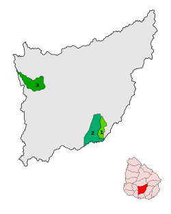
The department of Florida has 3 municipalities. The first two were created by means of Law No. 18,653 of March 15, 2010, these being the municipalities of Sarandí Grande and Casupá.
The third municipality was created in 2015 at the initiative of the departmental mayor, this is the municipality of Fray Marcos.
| Map | Municipality | Surface (km2) | Population (Census 2011) | Headquarters |
|---|---|---|---|---|
 | Casupá | 94.7 | 2228 | Casupá |
 | Fray Marcos | 279.4 | 3432 | Fray Marcos |
 | Sarandí Grande | 211.5 | 6509 | Sarandí Grande |
Urban centers
The only two cities in the department are Florida, its departmental capital, and Sarandí Grande, the second town in terms of population.
The following are towns or cities with a population of 1,000 or more (2011 census data):
| City/Pueblo | Population |
|---|---|
| Florida | 33 640 |
| Sarandí Grande | 6130 |
| Casupá | 2402 |
| Fray Marcos | 2398 |
| 25 May | 1852 |
| 25 August | 1849 |
| Alejandro Gallinal (or Cerro Colorado) | 1357 |
| Cardal | 1202 |
| Nico Pérez | 1030 |
Other towns with less than 1000 inhabitants are:
|
|
|
The towns of Cerro Chato, Illescas and Valentines have the peculiarity of being located on the border with other departments, so their administration in such cases is shared with the neighboring department. Cerro Chato, is located on the border of the departments of Florida, Durazno and Treinta y Tres; Valentines on the Florida border with Treinta y Tres; and Illescas on the border with Lavalleja. On the other hand, the town of Nico Pérez, although it is located next to the border with the department of Lavalleja, its urban plan is fully developed in the Florida territory, while on the side of Lavalleja is the town of Batlle y Ordóñez.
Places of interest
The largest city in the department is also its capital, Florida, where you can find places of interest such as Piedra Alta, a place of great national and regional historical significance. In the city, places such as the Assembly Square, the Basilica Cathedral, which is a sanctuary to the Virgin of the Thirty-Three; the San Cono chapel, patron saint of the department, is widely attended every June 3 to celebrate the day of San Cono, by pilgrims who arrive from various sectors of the country and surrounding areas; Robaina Park and Piedra Alta Prado, among others.
In the department there are several ranches dedicated to rural tourism, among them El Ceibo and San Pedro del Timote. In turn, the lake of the Paso Severino dam stands out as a center of attraction.
Notable personalities
- Duvimioso Terra, lawyer and politician, first Dean of the Faculty of Law of the University of the Republic.
- Julio Castro Pérez, educator and journalist kidnapped and killed by the civic-military dictatorship.
- Mario Delgado Aparaín (1949-), journalist, writer and teacher, as well as one of the main narrators of Uruguay.
- Mario Carrero, musician, is part of the duo Larbanois & Carrero.
- Pedro Varela (1837-1906), Uruguayan politician and Acting President of the Republic in 1868. Provisory Governor from 1875 to 1876.
- Wilson Ferreira Aldunate (1919-1988), a Uruguayan politician and chief civil leader of the National Party from the 1970s to his death in 1988.
- Pocho Fernández (1883-?), a revolutionary soldier in two homelands, defending the white currency.
Elections (Presidential/Municipal)
Florida is a department with a developed white tradition, however, Colorado leaders and Frente Amplistas have conquered this department, as is the case of Julio María Sanguinetti of the PC and Tabaré Vázquez of the EP-FA.
Contenido relacionado
Territorial organization of Namibia
Historical center of lima
Quirós


