
Federal dependencies of Venezuela
The federal dependencies are the portions of territory of Venezuela not included within the Federal Entities and the Capital District, as well as the islands that are formed in the territorial sea or in the one that covers the continental shelf. This dependency is organized into 12 groups of islands; however, there are another 89 islands that remain under the control of other Venezuelan states given their proximity to the coasts of the states of Anzoátegui, Aragua, Carabobo, Falcón, Miranda, Nueva Esparta and Sucre. All this includes the maritime space of Venezuela.
The Federal Dependencies generate a Territorial Sea for Venezuela, where full National Sovereignty is exercised and in accordance with the Laws of the Sea of the riparian countries, this chain of islands is the starting point to establish the delimitations of the 200 miles, Thus generating the exclusive economic zone, a space of marine and submarine areas of approximately 860 km², according to the Simón Bolívar Geographical Institute of Venezuela, also called heritage sea. Venezuela, based on its Caribbean territories, has delimited its maritime borders with 5 countries, namely, the United States of America, France, the Netherlands, the Dominican Republic and Trinidad and Tobago.
The set of islands scattered in the Caribbean Sea and to a lesser extent in the Venezuelan Atlantic have an average annual temperature of between 26 and 28 °C, with rainfall of between 300 and 500 millimeters per year. The estimated population for the year 2015 in the Federal Dependencies is 6,500 inhabitants, making it the least populated area in the country.
History

On November 8, 1777, the Royal Decree of Carlos III of Spain recognized that the group of Spanish islands close to the southeast of the Caribbean Sea would remain under the jurisdiction of the General Captaincy of Venezuela. With Venezuelan independence, all the islands remained in the domain of Venezuela and in the same way until the formation of Gran Colombia. In 1830 Venezuela separated from Gran Colombia and regained sovereignty over its islands in the Caribbean. On March 30, 1845 Venezuela and Spain sign a Treaty of Peace and Friendship in which Isabel II of Spain officially recognizes the independence of Venezuela in addition to recognizing all the territories and islands that corresponded to the General Captaincy of Venezuela at the time. of the independence.
On April 28, 1856, a new Law of Territorial Political Division was decreed where the creation of the Province of Margarita was resolved, one of its cantons called North Canton was made up of 10 parishes, of which 4 are part of what are today some of the current Federal Dependencies, these are, San Juan and the Tortuga, Blanquilla, Witnesses and Aves de Barlovento Islands with all those that are adjacent to it.
The United States begins the exploitation of guano on Isla de Aves in the middle of the XIX century, Venezuela claimed sovereignty over the islands and after a long legal dispute, the United States recognized Venezuelan sovereignty over the island in 1861. The Netherlands claimed the islands but the conflict was resolved by arbitration in 1865, once again recognizing Venezuelan sovereignty over Isla de Aves.
On August 22, 1871, Venezuelan President Antonio Guzmán Blanco decided to group all the Venezuelan islands except Coche, Cubagua, Margarita and Isla de Aves as Colon Federal Territory, which would be controlled by a governor appointed by the President of the Republic. Later, under the presidency of Joaquín Crespo, on July 4, 1895, the Isla de Aves was included within the Federal Territory of Colón by national decree. On May 16, 1905, Cipriano Castro decided to include Coche Island within the Colón Territory, establishing his capital in San Pedro de Coche; however, this decision lasted a short time before the protests that the government received from the Island of Margarita; After three years, on August 31, 1908, the island was returned to Nueva Esparta and the Colon Federal Territory was dissolved, establishing direct control of the islands to the National Executive.
On July 4, 1938, the Organic Law of Federal Dependencies was promulgated under the government of Eleazar López Contreras, which completely regulates the situation of the islands. The United Kingdom claimed the Isla de Patos but on February 26, 1942 it was resolved by delimiting the soil and subsoil of the Gulf of Paria. The Archipelago of Los Monjes, which Venezuela integrated as part of its territory, was the subject of controversy, but in 1952 the Colombian foreign minister recognized Venezuelan sovereignty over the territory through a diplomatic note and in 1992 the Colombian government affirmed that it would not claim the territory. On August 23, 1972, Bird Island was declared a National Wildlife Refuge. On June 2, 1978, the "Simón Bolívar" In Isla de Aves, that same year an attempt was made in the Chamber of Deputies of the then National Congress to approve a bill for the creation of the Caribbean Archipelago Territory, however this proposal could not be carried out because it was against some provisions of the Constitution of Venezuela of 1961, to this day, a possible restructuring of the Federal Dependencies has not been discussed again. On March 28 and 31, 1978, the definitive maritime limits with the United States (1978 Treaty between the United States and Venezuela) were signed, which set the limits with Puerto Rico and the United States Virgin Islands. and the Netherlands (1978 Treaty between the Netherlands and Venezuela) that set the limits with the Netherlands Antilles, then on July 17, 1983 it did the same with France. These three treaties establish the current continental shelf and exclusive economic zone of Venezuela in the Caribbean Sea. On April 4, 1986, the National Directorate for the Coordination of Border Development and Federal Dependencies was created, under the Ministry of the Interior and Justice, for the administration of the territory.
In October 2011, a new decree was approved as an organic law for the Federal Dependencies and island territories.
Island table
According to the most recent estimates, the extension of the Federal dependencies is 342.25 km² without including the small archipelago of the Caracas Islands. The islands, their groups and archipelagos are named below:
 Island of venezuela birds, federal venezuela units (12) .svg) Administrative political map of federal units ordered by the numbering of the islands table | |||||
| Nr. | Island or group | Surface km2 | Population | Member Islands | Coordinates |
| Within the Continental Shelf | |||||
| 1 | Archipelago Los Monjes | 0.20 | - | Northern Monks - Eastern Monk - South Monks | 12°21′N 70°55′O / 12.350, -70.917 |
| 2 | Tortuga Island and adjacent Cays | 156.60 | La Tortuga Island - Los Tortuguillo Islands - Cayo Herradura - Los Palanquines - Cayos de Ño Martín - Islote El Vapor - Cayos de Punta de Ranchos | 10°55′N 80°31′O / 10.917, -80.517 | |
| 3 | Island La Sola | 0.0005 | - | Island La Sola | 11°18′N 63°34′O / 11.300, -63.567 |
| 4 | Islands Witnesses | 6.53 | 197 | Isla Conejo - Isla Iguana - Isla Morro Blanco - Isla Rajada - Isla Noroeste - Peñón de Outside - Isla Testigo Grande | 11°22′N 63°06′O / 11.367, -63.100 |
| 5 | Fraile Islands | 1.92 | - | Chepere - Guacaraida - Puerto Real - Nabobo - Cominoto - Macarare - Guairiare - Guacaraida - La Balandra - La Peche | 11°12′N 63°44′O / 11.200, -63.733 |
| Outside the Continental Shelf | |||||
| 6 | Island of Patos (East) | 0.60 | - | Island of East Patos | 10°38′N 61°52′O / 10.633, -61.867 |
| 7 | Archipelago Los Roques | 40,61 | 1300 | Gran Roque - Francisquí - Isla Larga - Nordisquí - Madrisquí - Crasquí - Dos Mosquises - Cayo Sal - Cayo Nube Verde - Cayo Grande - Noronquí - Espenquí - Carenero - Selesquí - Bequevé - Cayo de Agua - Cayo Grande Other | 11°51′N 66°45′O / 11.850, -66.750 |
| 8 | Island La Blanquilla | 64.53 | - | Island La Blanquilla | 11°50′N 64°35′O / 11.833, -64.583 |
| 9 | Islands The Brothers | 2,14 | - | La Orquilla - Isla Los Morochos - Isla Grueso - Isla Pico (or Isla Pando) - Isla Fondeadero - Isla Chiquito | 11°45′N 64°25′O / 11.750, -64.417 |
| 10 | Island La Orchila | 40 | - | La Orchila Island - Cayo Agua - Cayo Sal - Cayo Northeast | 11°47′N 66°10′O / 11.783, -66.167 |
| 11 | Archipelago Las Aves | 3.35 | - | Aves Island of Barlovento - Treasure Island - Cayo Bubi - Cayo de Las Bobas - Aves Island of Sotavento - Long Island - Cayo Tirra - Saquisaqui Island - Cayos de La Colonia - Maceta Island - Cayo Sterna | 12°00′N 67°40′O / 12,000, -67.667 |
| Abisal Fund | |||||
| 12 | Island of Aves (North) | 0.045 | - | Island of Aves | 15°40′N 67°37′O / 15.667, -67.617 |
| Federal Units | 306,53 | 1497 | |||
Politics and government
This federal entity is the only one in the entire Republic that does not have a Governor or Mayor, since it has neither the status of a Federal State nor that of an Autonomous Municipality, it is a special Administrative division contemplated in article 17 of the Constitution:
"Federal units are non-integrated maritime islands in the territory of a State, as well as islands that form or appear in the territorial sea or where the continental shelf is covered. Its description, geographical position, regime and administration will be noted in the law. ".
According to the Organic Law of Federal Dependencies of 1938 in force until 2011, everything related to the government and administration of said dependencies corresponds directly to the Federal or National Executive (Art.3) They are under the administration of the National Directorate for the Coordination of Border Development and Federal Dependencies. Even though the D.F. they do not make up a federal state, they are part of the Insular Region together with the Nueva Esparta State, currently there are several solution proposals for the ambiguous condition of the Federal Dependencies some currents maintain that the islands should be integrated into the territories of the closest Federal States, and others, which must be elevated to the category of State within the Federation in order to promote their sustainable development at all levels, without disintegrating the identity that they have developed as a geographical and cultural group. The populated sites of the Federal Dependencies used to have a General Commissioner appointed by the President of the Republic and in the case of the Los Roques Archipelago this was administered by a Single Area Authority (Created in 1990) also appointed by him, which had jurisdiction on the territory of the national park of the same name until 2011.
On October 15, 2011, the presidency of the Republic of Venezuela issued a decree with the rank, value and force of an organic law that created new legislation for the Federal Dependencies, through a new organic law that repeals the 1938 law and which establishes that the political and administrative organization of the dependencies will be articulated through island territories and the minor districts of development. On October 27, the law was endorsed by the Supreme Court of Justice and was published in the Official Gazette 39,787.
In August 2011, the presidency of the republic, using its enabling legislative powers, promulgated the law creating the first insular territory of the Federal Dependencies called Territorio Insular Miranda with its capital in Gran Roque, covering the central sector of the Federal Dependencies.
Island Territories
| Territory | Federal units | Surface | Population | Head of Government | Map |
|---|---|---|---|---|---|
| Francisco de Miranda | Las Aves — Los Roques — La Orchila | 83.96 km2 | 1,300 (2007) | Eladio Jiménez Rattia (2020-Updated) | .svg) |
The Turtle

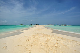
The island La Tortuga belonging to Venezuela, being included within the Venezuelan Federal Dependencies. It is located in the southern Caribbean Sea at 65° 18' west and 10° 55' north, about 30 km from Río Chico (Miranda), Miranda state; 170 km from Caracas; 140 km from Margarita Island; about 85 km from the Unare lagoon in the state of Anzoátegui State and 120 km from the state of Nueva Esparta. The shape of the island is similar to an ellipse of 12 km measured from North to South and 25 km from East to West. Together with the adjacent keys, it is approximately 156.6 km² long, which makes it the second largest in Venezuela (the main island is 156.6 km²), after Margarita. It is part of an archipelago that includes the islets of Las Tortuguillas, Cayo Herradura, Los Palanquines, the Cayos de Ño Martín, Isla Vapor and Punta de Ranchos.
It is highly visited by migratory birds and fishermen who frequent the island between the months of September and April. During this time you can catch species such as corocoros, rays, groupers, snappers and lobsters. It was discovered in 1499 by Alonso de Ojeda on his trip with Américo Vespucci and he called it La Tortuga due to the enormous presence of these marine reptiles. It used to be a haven for pirates in the 17th century, although it should not be confused with Turtle Island in Haiti, which is the most named in the piracy literature. The pirate Morgan prepared from it his famous incursions to the coasts of Venezuela. It was populated by Dutchmen who exploited the salt flats in the east of the island, possibly from 1550 onwards and who were definitively expelled in 1631 when the governor of Cumaná destroyed their installations and flooded the salt flat. Since then it has not had a permanent population and due to its location and morphology, it has remained forgotten for centuries, which makes it one of the last virgin places in South America.
La Blanquilla Island

La Blanquilla Island belonging to Venezuela, administered as one of the Venezuelan Federal Dependencies (64° 35´ and 11° 50´N) of approximately 64.53 km² of extension, located at Latitude 11º51' North and Longitude 64°36' west. 90 km north of Isla de Margarita and 170 km northwest of Puerto La Cruz.
It has a coastline length of 25 km and a maximum height of 30 m. Known for its white sand beaches (hence its name), there is a military base and installations, a Navy station, and an airstrip. The Island is completely virgin, almost uninhabited, in its purest natural state. It is arrow-shaped and consists mainly of limestone. Cataloged as a charming island for its turquoise blue water beaches and white sands, it also has shallow coral reefs with a lot of Biodiversity and a great wealth of underwater life, which is why it is ideal for snorkeling and diving. Dive. In its calm waters it is possible to observe dolphins, small pilot whales or Olive Ridleys, Sharks, Giant Rays and Mantas.
The Rocks

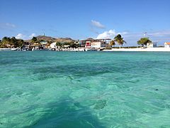
The Los Roques Archipelago is a group of islands and cays in the Lesser Antilles belonging to Venezuela, which has an estimated area of 40.61 km² and is located approximately 176 km north of the city of Caracas. Being one of the main tourist attractions in the country, it is part of the Venezuelan Federal Dependencies, it is a national park and in 2001 it had 1,300 fixed inhabitants (being the most populous federal dependency). The park has an approximate area of 221,120 hectares between maritime and terrestrial areas, and is considered one of the largest marine parks in Latin America (See Los Roques Archipelago National Park). This park is made up of 42 keys of coral origin and a large number of sandbanks, some with a considerable area (such as Cayo Grande, with an area of 15.1 km²), and some smaller ones, such as Gran Roque, despite Although it is the most populated, it only has an area of 1.7 km² (170 hectares).
The Archipelago of Los Roques, is a Federal Dependency since 1938, declared a national park in 1972 that has neither a governor nor a mayor, instead it is administered by a Single Area Authority according to presidential decree Number 1214 of November 2, 1990, integrated into the Federal Dependencies, which are administered directly by the National Executive. It has financial, budgetary and management autonomy. The Los Roques archipelago is a national park. The park has one of the most diverse and best preserved coral reefs in the Caribbean Sea. The biggest limitation for tourism development, in addition to its status as a national park that establishes rigid controls on commercial activities, is the lack of rivers and other permanent sources of fresh water. 90% of the lobsters consumed in Venezuela come from Los Roques.
Orchila Island

La Orchila Island is included in the Venezuelan Federal Dependencies. It has an extension of approximately 40 km² and is located (66° 10' W and 11° 47' N) about 180 km from the Venezuelan capital, Caracas. It is the headquarters of a military camp to which only the President of Venezuela and senior government officials have access. Tourism is only possible with military authorization.
Los Frailes Archipelago

The Los Frailes archipelago is a group of 10 islands that belong to Venezuela and are included in the Venezuelan Federal Dependencies in the Caribbean Sea, with a total surface area of 1.92 km², some of which retain their given name by the Caribbean Indians: Chepere, Guacaraida, Puerto Real, Nabobo, Cominoto, Macarare, Guairiare, Guacaraida, La Balandra and La Peche, are uninhabited and are located on the northeast coast of Isla de Margarita. The largest island is the so-called Fraile Grande or Puerto Real, it has a maximum length of 2,200 m and occupies an area of 0.75 km². To the northwest of Fraile Grande is the Morro de la Pecha and Morro Blanco and to the northwest of the archipelago the islets of Cominoto and Chaure.
Las Aves Archipelago

The Las Aves Archipelago belonging to Venezuela, of approximately 3.35 km² administered as one of the Venezuelan Federal Dependencies, located between Bonaire to the west and the Los Roques Archipelago to the east, north of the Venezuelan states of Aragua and Carabobo (12°00′N 67°40′W / 12.000, -67.667). At present they are important mainly for fishing. The archipelago is formed mainly by two reef complexes:
- Birds of Barlovento, the eastern group, a reef with 8 km diameter and three cays in the southwest
- Birds of Sotavento, the Western group, with a cay covered with mangrove, in the south
In total, there are 13 cays in both groups. It should not be confused with Isla de Aves, which is much further away from the Venezuelan coast.
Los Testigos Archipelago

Archipelago belonging to Venezuela, which is part of the Venezuelan Federal Dependencies. It is located northwest of the Isla de Margarita and is made up of seven islands with a population of 197 inhabitants for 2001, mostly of Margarita origin, as a whole they have approximately 6.53 km² of surface, among the most prominent are: Isla Conejo, Isla Iguana, Isla Morro Blanco, Isla Rajada, Isla Noroeste and the largest, Isla Witness Grande. They can be reached by boats that depart from the Isla de Margarita.
Bird Island

Isla de Aves is a small and remote island of the Venezuelan Federal Dependencies, approximately 4.5 ha, located in the Caribbean Sea, west of the Leeward Islands (15° 40′N 67°37′W / 15.667, -67.617), 110 km west of Guadeloupe and Dominica. It has a length that does not exceed 150 m and its maximum height is 2 m s. no. m. on a calm day. On some occasions, during strong storms, the island is completely submerged. The island is part, Venezuela. A military base has been installed in it by the Venezuelan naval forces. Some Caribbean states together with Dominica claim this island as part of the latter, called by them as Bird Island. However, this claim has not been recognized by Venezuela, since the island represents a political-territorial stronghold of the republic, since it extends the territorial waters of Venezuela from its coast to practically the center of the Caribbean Sea.
The conflict that the Netherlands filed from 1854, for the possession of Isla de Aves located 500 km from the Isla de Margarita, was resolved by means of an arbitral award that declared the small Isla de Aves, as a Venezuelan space, Isabel II of Spain had been appointed as arbitrator at the request of both countries, in 1860, who issued a sentence on June 30, 1865 in favor of Venezuelan rights to the island. On August 23, 1972, the island was declared a wildlife sanctuary. In 1978, the Venezuelan Navy established a military garrison on the island under the name of Simón Bolívar Scientific-Military Base. The impact of Hurricane Allen in 1980 divided the island into two parts, but the increase in coral on the island was able to reunify it.
Los Monjes Archipelago

Los Monjes Archipelago is a disputed archipelago between Colombia and Venezuela, 34.8 km east of the Guajira Peninsula, Colombia, and 80 km northeast of Zulia state in the Gulf of Venezuela. Los Monjes 12°21′N 70°55′W / 12.350, -70.917 are made up of three groups of rocks or uninhabited islets (there is only a military presence of the Navy Venezuelan) and without its own vegetation, located in the Caribbean Sea just 31 km from the Guajira peninsula.
- Monks of the South (12°22′N 70°54′O / 12.367, -70.900), are the two largest islets connected by an artificial dam, the islet of the south with 70 m of altitude and with a lighthouse.
- Monk of the East (12°24′N 70°51′O / 12.400, -70.850), 5.3 km northeast of Monjes del Sur, a small island 43 m at altitude.
- Northern Monks12°30′N 70°55′O / 12.500, -70.917), 12.3 km north-west of Monjes del Este, are five small rocks. The largest one has an altitude of 41 m.
Historical controversy

In 1952, in Colombia the official magazine "National Territories" published a letter stating that the Los Monjes Archipelago was part of Colombia, in turn on January 17 the Foreign Ministry The Venezuelan issue a statement in which it claims the sovereignty of Venezuela over Los Monjes, which is signed by Foreign Minister Luis Emilio Gómez Ruiz and Defense Minister Colonel Marcos Pérez Jiménez. On August 15, the Colombian Navy ship ARC Almirante Padilla carried out target practice against the islets of Los Monjes. When the news reached the Ministry of Defense of Venezuela, a maximum alert was ordered in the military facilities and that the Venezuelan garrisons in the border area with Colombia be reinforced, the deployment of the Patria corvettes was ordered., Federation and Victoria of the Venezuelan National Navy towards Los Monjes. The 36th fighter squadron of the Venezuelan National Aviation left Maracaibo to carry out border patrols in support of the ground forces. When the Venezuelan troops disembarked, the Venezuelan flag was raised and the Venezuelan National Anthem was sung.[citation needed] The acting Colombian president, Roberto Urdaneta Arbeláez, recognized the sovereignty of Venezuela on the islets of Los Monjes through a diplomatic note:
The Government of Colombia declares that it does not object to the sovereignty of the United States of Venezuela over the archipelago of Los Monjes and that it does not object or object to the exercise of the same or any act of claim to be made in respect of the exercise of the same or any act of dominion of this country over the archipelago in reference.
On August 5, 1987, the Colombian corvette ARC Caldas sailed in disputed waters between the two nations, very close to the Los Monjes Archipelago. After several days of tension, in which there was a large military mobilization by both countries, the ship withdrew. The Venezuelan government built and maintains a lighthouse and a Navy station, in addition to building a bridge between two of its islands, and finished building facilities for fishermen in recent years, in order to comply with the requirement that allows the islands generate exclusive economic zone and territorial sea rights, as long as some type of economic activity is carried out on them (in this case fishing). In 2015, the Venezuelan government denounced a new incursion of Colombian and American frigates, which triggered a new diplomatic crisis.
Duck Island

The Isla de Patos is an island belonging to Venezuela, whose extension is slightly less than one square kilometer, it is administered as one of the Venezuelan Federal Dependencies of which it is the easternmost, and located in the Gulf of Paria (61° 52'W and 10° 38' N), eight kilometers from the southeast of Sucre State. It was recognized as part of Venezuela in the treaty signed with the United Kingdom of Great Britain and Northern Ireland through which the latter returned, as part of an agreement to delimit the marine surface between Venezuela and the, at that time, British colony of Trinidad and Tobago, the territory corresponding to that island, document that delimited the soil and subsoil of the Gulf of Paria, between Great Britain and Venezuela, dated February 26, 1942.
Tourism

The Venezuelan islands represent enormous tourist-recreational potential, presenting singular scenic beauties, constituting one of the most beautiful places in the country, with various attractions located on and off the mainland, as well as a diversity of tropical beaches and large formations corallines.
The Los Roques Archipelago, together with Isla de Aves and Isla la Orchila make up the "oceanic islands", separated from the continental shelf by deep channels and bathed by warm, transparent oceanic waters. Los Roques has been one of the areas that has presented the greatest development of its tourist services, hence its importance as a center of recreation for foreigners and Venezuelans. El Gran Roque is the only center that has some infrastructure for tourist accommodation, although plans have recently been approved to create tourist developments on uninhabited islands such as La Tortuga Island.
- Some islands and cays
Waterfall

Island of Crasqui

Two Mosquis

Los Roques

Cayo Pirata

Cayo Francisqui
Isla Gran Roque


International and local disputes
The disputes over the Federal Dependencies between the states of Venezuela, and between Venezuela and other countries, are the following:
Locals
- The state La Guaira calls for itself the authority over the archipelago of Los Roques.
International
- The Republics of Granada, Dominica and the British colony of Montserrat claim Venezuelan sovereignty over Aves Island, approximately 500 km from Caracas and 100 km from Dominica, the existence and adjudication (which began because it was part of the Venezuelan General Office) by Venezuela turns the country into one of the largest possessors of territory on the Caribbean Sea, besides being the country with the most coasts on it, the island is of geostrategic importance
- Colombia calls for sovereignty over part of the territorial and submarine waters of the Gulf of Venezuela, according to its interpretation of colonial documents and the proximity of the islands to the Peninsula of Guajira (38 km away). Venezuela alleges the belonging of the vast majority of the Gulf waters, since the Archipelago Los Monjes is within these waters and notes that during the Treaty of Peace and Friendship that signed the queen of Spain Isabel II, on March 30, 1845, Venezuela is recognized as a free, sovereign and independent nation, the provinces and any other territories and islands that might correspond to it in which the Gulf, the Federal Units among others are included. In 1891, under the arbitration of Queen Maria Cristina of Spain, most of the Peninsula of La Guajira was granted to Colombia. In 1952 the Colombian government recognized Venezuelan sovereignty over the Monks but the dispute over the sea has not yet been resolved and since the end of the centuryXIX Venezuela has exercised greater presence and authority over most of the Gulf waters[chuckles]required].
Caldas corvette crisis
_y_ARV_Mariscal_Sucre_(F-21)_-_1987-09855.jpg)
On August 19, 1987, two Colombian warships entered the territorial waters of the Los Monjes Archipelago near the Gulf of Venezuela, where Colombia has claims to a territorial dispute without it being recognized or taken into account by Venezuela who exercises sovereignty in the area for more than 150 years.
When this movement was detected, the Venezuelan president at the time, Jaime Lusinchi, authorized a large mobilization of the Venezuelan armed forces, including F-16 planes that flew over the Colombian ships, waiting for orders to attack. This military impasse was caused by the dispute concerning sovereignty in the Gulf of Venezuela, on which there is no boundary line accepted by both countries. Both Venezuela and Colombia have unilaterally delimited it, which is why the patrol areas of their Navies overlap. The "Crisis of the Corvette Caldas" It was not the first time that there was a risk of an armed confrontation in the Gulf of Venezuela.