
El Salvador Geography

El Salvador is the smallest country in Central America and the only one that does not border the Caribbean Sea. Still, with its almost 7 million inhabitants, it is the most densely populated in the region. It is bordered to the south by the North Pacific Ocean, to the northwest by Guatemala, and to the north and northeast by Honduras. In the southeast, the Gulf of Fonseca separates it from Nicaragua. El Salvador is about the same size as Slovenia or Israel, but has the population size of Libya and Lebanon.
Geographic details
.jpg)


Two parallel mountain ranges cross El Salvador to the west, with a central plateau between them and a narrow coastal plain along the Pacific. These characteristics divide the country into two physical regions. The mountain ranges and the central plateau occupy 85% of the territory, with the highlands. The rest is occupied by the coastal plain.
The northern cordillera is a continuation of the Sierra Madre de Chiapas that begins in Mexico and runs through Guatemala, and forms a continuous mountain range along the border with Honduras, descending from northwest to southeast. It has two sectors cut by the Lempa River. The heights in this region oscillate between 1,600 and 2,700 m. To the northwest, the Sierra de Matapán-Alotepeque stands out, with the top of Montecristo, 2,418 m, around the Montecristo National Park, and to the east, the Nahuaterique mountain range or mountain range and the Cacahuatique or Corobán mountain range or hill, of 1,663 m. The area has been heavily deforested. This overexploitation, followed by intense erosion, has degraded the land. The consequence is the least populated area of the country, with small farms. The highest mountain in the country is Cerro El Pital, at 2,730 m, in the Sierra Madre de Chiapas, between Honduras and El Salvador, surrounded by a cloud forest and the coldest climate in the country, as it can freeze between December and March, with 1,534 mm of precipitation between May and October.
El Salvador is a territory of volcanic origin, located in the tropical zone. From any panoramic point that is contemplated, the landscape of the country is dominated by volcanoes.
The central plateau constitutes only 25% of the surface but contains most of the population and the largest cities of the country. This plain is 50 km wide and has an average elevation of 600 m. The terrain is undulating, with some escarpments, lava fields, and geysers.
Between the volcanic chain and the coast there is a narrow plain that has a maximum width of 32 km to the east, next to the Gulf of Fonseca. Near La Libertad, however, the slopes of the volcanoes fall directly into the ocean. The surfaces along the Pacific are generally flat or slightly undulating and are caused by alluvial deposits from the nearby slopes.
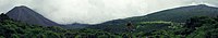
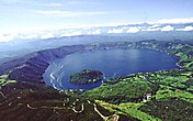
Izalco Volcano View and Ilamatepec Volcano from Cerro Verde

Vista de Cerro Verde, Volcán de Izalco y Lago de Coatepeque desde Volcán Ilamatepec

View of San Salvador from Volcano de San Salvador
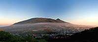
Volcano of San Salvador.

View of Gulf of Fonseca from Volcano de Conchagua

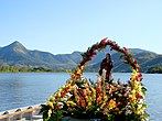
El Balsamar, La Libertad
.jpg)

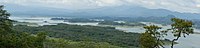
Hydrography

River Lempa
Lake Suchitlán
Laguna de Olomega


El Salvador has around 300 rivers. The most important is the Lempa River, which originates in Guatemala, crosses the Sierra Madre, flows through the central plateau and ends up cutting the volcanic chain to pour into the Pacific. It is the only navigable river in El Salvador, and its tributaries drain half the country. The other rivers short and drain through the lowlands or flow from the central plateau forming gorges in the volcanic chain on their way to the Pacific.
In the interior highlands there are numerous lakes of volcanic origin. Many are surrounded by mountains that have steep slopes. The largest is Lake Ilopango, at 440 m and with 72 km², to the east of the capital. Other lakes are Lake Coatepeque, at 746 m and 26 km², to the west, and Lake Güija, on the border with Guatemala, at 430 mm and 45 km². The Cerrón Grande reservoir, measuring 3,135 km² and with an installed capacity of 170 MW in the power plant, has been built on the Lempa river.
Volcanism
Lake Coatepeque

Lago de Ilopango

Apaneca mountain range

Volcano of Usulután

Volcano de San Vicente

Izalco Volcano

Volcano de San Miguel


.jpg)


El Salvador, along with the rest of Central America, is one of the most seismically active regions on Earth, situated between three major tectonic plates, whose movement causes volcanic activity in the country.
Much of Central America and the Caribbean Sea lie on the relatively immobile Caribbean plate. The Pacific Ocean floor, in contrast, is being pushed northeast by the underlying movement of the Cocos plate. The ocean floor is composed mostly of basalt, which is relatively dense; when the lighter granite in Central America collides, the ocean floor is forced to submerge beneath the land mass, creating the deep Mesoamerican trench found off the coast of El Salvador.
Subduction of the Cocos plate explains the frequency of earthquakes near the coast. As the rocks that make up the ocean floor are forced downward, they melt, and the molten material, lava, rises through the weak parts of the rock to the surface, giving rise to volcanoes and geysers.
Northern El Salvador, Mexico, and most of Guatemala are pushed by the westward motion of the North American plate, which is pushing against the northern edge of the immobile Caribbean plate in southern Guatemala. The rubbing action of these two plates creates a fault (similar to the San Andreas fault in California) that runs along the Motagua River valley in Guatemala. The movement along this fault, with numerous derivations, is a source of earthquakes in El Salvador.
El Salvador has a long history of destructive earthquakes and volcanic eruptions. San Salvador was destroyed in 1756 and 1854, and severely damaged by earthquakes in 1912, 1982 and 1986. The country has some 20 volcanoes, although only two, San Miguel and Izalco, have been active in recent years. From the early 19th century to the mid-1950s, Izalco erupted regularly to the name of Faro del Pacífico. Its brilliant emissions are visible at great distances in the sea, and at night the lava turns the cone into a brilliant light.
Volcanoes of El Salvador

It is considered that in El Salvador there are 23 volcanoes divided into five groups from west to east. Those that have erupted in the last 500 years are considered active. Craters larger than 1.5 km that store water during calm periods are called crater lagoons.
| Volcano | Altitude | Department | Type | Membership | Last eruption |
| Santa Ana, Ilamatepec | 2.382 m | Santa Ana | Stratevolcano | Basalto de olivino y piroxeno | 2005. |
| Izalco | 1950 m | Sonsonate | Stratevolcano | Basalto de olivino | 1966 |
| San Marcelino, Cerro Chino | 1,780 m | Sonsonate | Cone de escorias | Olivin and Augita Basalt | XVIII century |
| San Salvador, Quezaltepec, El Boquerón | Picacho: 1,960 m; El Boquerón (crater): 1,840 m | La Libertad, San Salvador | Volcanic complex, stratumvolcano | Basalto and Andesita | 1917 |
| The Playon | 660 m | San Salvador; Volcano Complex of the San Salvador Volcano | Cone of slag and lava by lateral mouth | Olivin and Augita Basalt | 1658-1659 |
| Burnt Islands | 450 m | Lake Ilopango, San Salvador | Lava dome | Dacita and hornblenda | 1879-1880 |
| San Miguel | 2.130 m | San Miguel | Stratevolcano | Olivin and Augita Basalt | 2017 |
| Conchagüita | 505 m | Gulf of Fonseca, Department of the Union | Stratevolcano | Basalto | 1892 |
| Conchagua | 1.225 m | The Union | Stratevolcano | Basalto | Fumarolas |
| Saint Vincent | 2.182 m | La Paz | Stratevolcano | Andesita | It's not known. |
| Apastepe | 600 m | Saint Vincent | Collapse and explosion craters | Basalto, domos de andesita and dacita with 24 cones | Not known. |
| Tecapa | 1.593 m | Usulután, 13.49°N / -88.5°W | Stratevolcano | Olivin and Augita Basalt | Not known. |
| Usulután | 1.449 m | Usulután | Stratevolcano | Basalto | Not known. |
| San Diego | 800 m | Santa Ana, 14.27°N / -89.48°W | Cones of slag and stratevolcano, volcanic field | Basalto de olivino | Not known. |
| Cuyanausul or Apaneca | 1.840-2.036 m | Ahuachapán, 13.89°N / -89.79°W | Stratevolcans and geothermal areas with fumaroles | Basalto and Andesita | Not known. |
| Cerro Cinotepeque | 665 m | 14.02°N / -89.25°W | Young ash cones by the River Lempa | Basalto | Not known. |
| Coatepe | 746 m | Santa Ana, 13.87°N / -89.55°W | Caldera with a lake of 25 km2 | Andesita, piroxeno | Not known. |
| Chingo, Cerro Chingo | 1.775 m | Jutiapa, Santa Ana, border with Guatemala | Stratevolcano | Basalto, andesita | Not known. |
| Cerro Singüil | 957 m | Jutiapa, Santa Ana, border with Guatemala | Cone of slag on the slope of Chingo | Basalto | Not known. |
| Chinameca, The Pacayal | 1,300 m | San Miguel, 13.48°N / -88.33°W | Stratevolcano | Basalto | Smoking, earthquakes. |
| Cerro Guazapa | 1.438 m | Cuscatlán, San Salvador, 13.9°N / -89.12°W | Stratevolcano | Basalto | Not known, asleep |
| Lago de Ilopango | 450 m | Cuscatlán, San Salvador, La Paz, 13.67°N / -89.05°W | Volcanic boiler | Dacita, pumice | Century V a. C.. The 1879-1880 eruption forms Burnt Islands |
| Laguna Aramuaca | 181 m | San Miguel, 13.43°N / -88.11°W | Explosion crater | Piroclatures | Not known. |
Climate

Cerro el Pital, highest point in the country

Corral de Mulas, Usulutan
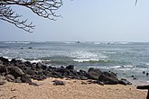
Playa Los Cobanos, Sonsonate

Sunzal beach, La Libertad

beach Salinitas, Sonsonate
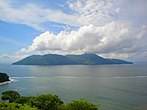
Meanguera Gulf of Fonseca Island

Gulf Meanguera

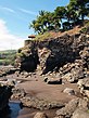
El Balsamar, La Libertad
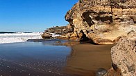
beach El Sunzal, La Libertad
beach El Zonte


.jpg)

_-_panoramio.jpg)


El Salvador has a tropical climate with pronounced dry and wet seasons. It is warm all year round on the coast and in the lowlands up to 150 m above sea level, in what is called hot lands, with a small difference between the seasons.
The wet season runs from April-May to October and is known locally as invierno. Almost all the annual rain falls during this very humid period, and on the slopes of the mountains facing south the 2000 mm is reached. In areas protected from the wind and in the central plateau it rains less. The rains are usually in the form of afternoon thunderstorms.
From November to April, the northeasterly winds change patterns. The air coming from the Caribbean Sea has lost almost all its moisture in the mountains of Honduras and by the time it reaches El Salvador it is dry and hot. This time is called summer.
Temperatures hardly vary except for altitude. The averages on the coast range between 25 and 29.oC. On the central plateau, San Salvador has an annual mean of 23.oC, with measured extremes of 6.oC for minimum and 38.oC for maximum. At heights, the averages drop to 12-13.oC.
In San Salvador, at an average altitude of 670 m, the falls are between 1,735 mm and 1,833 mm It is still in hot lands and temperatures range from 16 to 30.oC on January 20 and 30.oC in June. The rains are concentrated between the end of April and the beginning of November, with more than 300 mm between June and September, with 20 days of precipitation each month, and less than 10 mm between December and March.
In Acajutla, on the western coast, the highest temperatures range between 22 and 32.o C in January, and 24-33.oC in April, with a annual average of 26.3.oC. The sea temperature oscillates between 28 and 30.oC all year round. About 1700 mm of rain falls annually, with most of it between June and October.
Hurricanes rarely affect El Salvador, since coming from the Caribbean they discharge all their energy in Honduras. The exceptions are Hurricane Mitch in 1998, which caused severe flooding, and Hurricane Emily, in 1973.
Protected areas
The IUCN registers 168 protected areas in El Salvador that occupy 1,806 km², 8.78% of the country's surface, in addition to 665 km² of marine areas, 0.71% of the 94,238 km² that belong to El Salvador. Of these, 8 are national parks, 54 are simply protected areas, 1 is a protected area with resource management (Colima), 92 are natural areas and 4 are managed habitats. On the other hand, 2 are Unesco biosphere reserves and 7 are Ramsar sites.
National Parks
- El Imposible National Park, 5000 ha, proposed as the heritage of humanity by the pre-Columbian settlement of Cara SuciaCara Sucia, of the Cotzumalhuapa culture (600-900). Sandy beach, mangroves, alluvial plain and high volcanic lands covered with forest.
- Montecristo National Park
- National Park Los Volcanes
- San Diego La Barra National Park
- El Salto National Park
- Las Colinas National Park
- San Blas or Las Brumas National Park
- San Jose Miramar National Park
Unesco Biosphere Reserves
- Xirihualtique-Jiquilisco.
- Apaneca-Llamatepec.
Ramsar Sites
- Laguna de Olomega
- Güija Complex
- Natural protected area Laguna del Jocotal
- Embalse Cerrón Grande
- Complex Jiquilisco Bay
- Barra de Santiago Complex
- Jaltepeque Complex
Data

Geographic Coordinates: 13 50 N, 88 55 W
Map References: Central America and the Caribbean
Area:
Total:
21,040 km², although the Government concerns 20,742 km².
earth:
20,720 km²
water:
320 km²
Area - comparative:
slightly smaller than Massachusetts
Land borders:
Total: 545km
Guatemala 203 km,
Honduras 342 km
Border points with Guatemala:
Anguiatú
Location: Department of Santa Ana.
Distance: 120 kilometers from the capital city.
San Cristóbal
Location: Department of Santa Ana.
Distance: 98 kilometers from the capital city.
The Chinamas
Location: Department of Ahuachapán.
Distance: 120 kilometers from the capital city.
La Hachadura
Location: Department of Ahuachapán.
Distance: 126 kilometers from the capital city.
Border points with Honduras:
The Amatillo Location: Department of La Union. Distance: 209 kilometers from the capital city.
The Poy Location: department of Chalatenango. Distance: 92 kilometers from the capital city.
Perquin Location: department of Morazán Distance: 240 kilometers from the capital city.
Integration Bridge
Location: Department of Cabins
Distance: 110 kilometers from the capital city.
/p>
Coastal Line:
307 km
territorial waters:
200nm
Climate: tropical; rainy season (May to October); dry season (November to April); tropical in coastal areas; highland temperate
Plot:
mostly mountains with a narrow coastal belt and central plateau
lowest level:
Pacific Ocean 0m
highest level:
Hill El Pital 2,730 m

Natural Resources:
hydropower, geothermal power, arable land
arable land:
27%
permanent plantings:
8%
permanent herbage:
29%
Forests and woodlands:
5%
others:
31% (1993 est.)
Irrigated Land: 27,400 ha (in 2020)
Natural Hazards: known as the Land of Volcanoes; frequent and sometimes very destructive earthquakes, also destructive hurricanes are common.
Environment - current issues: deforestation; erosion; water contamination; soil contamination with toxins, damage from Hurricane Mitch
Environment - international treaties:
signed and ratified:
Biodiversity, Climate Change, Climate Change-Kyoto Protocol, Desertification, Endangered Species, Harmful Waste, Nuclear Test Ban, Ozone Layer Protection, Wetlands (Ramsar)
signed but not ratified:
law of the sea
Geography - note:
the smallest country in Central America and the only one with no outlet to the Caribbean Sea
.
Contenido relacionado
Eratosthenes
Kuroshio Current
Strait of Gibraltar