Eastern Sierra Madre
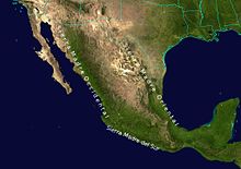
The Sierra Madre Oriental is a mountain range approximately 1,300 kilometers long with an orographic axis that runs in a northwest-southeast direction and extends from the Rio Grande to join the Neovolcanic Axis. More or less parallel to the coast of the Gulf of Mexico, it is bordered to the east by the Gulf Coastal Plain, and to the west by the Mexican Highlands. The Sierra Madre Oriental crosses the states of Coahuila, Nuevo León, Tamaulipas, Texas, San Luis Potosí, Hidalgo, Puebla, Querétaro, Tlaxcala and Veracruz.
The mountain range has a rugged topography in which valleys, canyons, and ravines are frequent. The highest peak is Cerro El Potosí with 3713 meters above sea level.
In the Sierra Madre Oriental there is a great diversity of flora and fauna, and some of these species are endemic. Biogeographically it is included within the region of the Madrean pine-oak forests.
Highest Points
| Position | Summit | State | Altitude (m s. n. m.) | Prominence (m) | Isolation (km) |
|---|---|---|---|---|---|
| 1 | Cerro El Potosí | Nuevo León | 3.714 | 1.870 | 569 |
| 2 | Sierra de la Viga | Coahuila | 3,712 | 1,395 | 63 |
| 3 | Sierra de la Marta | Coahuila, Nuevo León | 3,709 | 1.010 | 25 |
| 4 | The Coahuilon | Coahuila, Nuevo León | 3.575 | ||
| 5 | Sierra Peña Nevada | Nuevo León | 3,563 | 1,663 | 123 |
| 6 | Cerro El Viejo | Nuevo León | 3.528 | 1,202 | 25 |
Physiography
The Sierra Madre Oriental is also physiographic formed by more or less parallel anticlines between whose folds synclines or intermontane valleys are formed, it is divided into 8 subprovinces and 3 discontinuities.
Sub-provinces
- Serranías del Burro
- Sierras y Llanuras Coahuilenses
- Sierra de la Paila
- Pliegues Saltillo-Parras
- Sierras Transversales
- Great Sierra Plegada
- Sierras y Llanuras Occidentales
- Huasteco
Discontinuities
- Sierra de Tamaulipas
- Sierra de San Carlos
- Sierra de Otontepec
Contenido relacionado
Quetzaltenango
Indus river
Geology of the Moon


