
Douro
The Duero (in Portuguese, Douro, [ˈdoɾu]) is the most important river in the northwest of the Iberian Peninsula. It is born on the southern slope of the Urbión peak, at about 2,160 m above sea level, and flows into the Atlantic Ocean, in the Porto estuary. It is 897 km long, with 572 km in Spanish territory, 213 navigable through Portuguese lands (Duero navigation channel) and 112 km of an international nature, as its course coincides with the border between the two countries. In this last section, the channel narrows and deepens, forming the so-called arribes, protected with the creation of the Duero International natural parks in Portugal and Arribes del Duero in Spain.
It has the largest hydrographic basin in the Iberian Peninsula, occupying 98,073 km², of which 78,859 km² correspond to Spanish territory and 19,214 km² to Portuguese territory. The Spanish part includes territories of the autonomous communities of Castilla y León, Galicia, Cantabria, La Rioja, Castilla-La Mancha, Extremadura and the Community of Madrid, although slightly more than 98% of the surface corresponds to Castilla y León, a community in which stands out for its cereal crops, as well as for the production of high-quality wines, standing out, above all for its fame, those of the Ribera del Duero denomination of origin. Administratively, it runs through the Spanish provinces of Soria, Burgos, Valladolid, Zamora and Salamanca, and the Portuguese districts of Braganza, Guarda, Vila Real, Viseo, Porto and Aveiro. On December 14, 2001, the wine-growing region of the Alto Douro, which covers a large part of its route through Portugal, and where the Port wine vines are grown, was listed as a World Heritage Site by Unesco, in the category of cultural landscape.
It is the river with the highest absolute flow in the Iberian Peninsula. It has a dense network of tributaries that collect water from the Cantabrian mountain range, the Iberian system and the Central system, responsible for its high flow. Of all of them, the most important are the Pisuerga and the Esla, to the north, and the Adaja and the Tormes, to the south. In addition, with its 897 km, it is the third longest river on the peninsula, after the Tagus and the Ebro.
Place name
The origin of its name comes from the Latin Durius flumen, whose Greek equivalent is Δούριος ποταμός, and which in turn could have its origin in the Celtic root *dubro- and this from Proto-Celtic *Dur whose meaning could be “water” when compared to the terms dŵr (from Modern Welsh), dour (from modern Breton) or dobhar (from modern Irish).
The Romans may have adopted this name from the Celtic tribes that lived along its course and who worshiped the god Durius, personification of the Duero River and who was depicted holding a fishing net.
Geological history
Its geomorphological origin is in an endorheic basin that accumulated sediments in a central lacustrine system during a good part of the Cenozoic Era, until a drain was opened into the Atlantic. This could have happened either through a fluvial capture from the Atlantic (due to remontant erosion), or due to a climatic change to humid conditions that caused the water level in the basin to overflow. Tectonic activity since those periods has not generated significant relief and could not have substantially contributed to this change in drainage. Subsequently, and gradually, the current fluvial hierarchy of the basin would be established. It is unknown when the opening (exoreism) of the basin took place, but the most recent massive lacustrine sedimentation is about nine million years ago.
Length and flow rate
Its length is 897 km, of which about 213 km are Portuguese, 112 km are border (international) and the rest runs in Spain, about 572 km. Its basin belongs, for the most part, to areas with a dry climate, although its northern tributaries collect water from the Cantabrian mountain range, which is much more humid, in addition to the abundant contributions of the Tormes, Huebra and Águeda rivers to the south.
Its average flow, before flowing into the Atlantic, at the Porto gauging station, ranges between 650 m³/s and 675 m³/s, while on the border between Spain and Portugal it is 570 m³/s. The natural regulation is 840 hm³/year and its runoff coefficient is 31%. However, its relative flow is quite low: in Porto it varies between 6.6 and 6.7 l/s and per km². Only at its source is it fed by a pluvio-nival regime, since before passing through Soria it is already a river with a pluvial regime (typical of a continental Mediterranean climate), with the flood in December and March, and the low water in August and September.
Longitudinal profile
The longitudinal profile of the Duero is abrupt between the headwaters in the Picos de Urbión and Soria. There begins the low-sloping plateau section on tertiary land, along the wide channel and adjacent banks. Downstream of Zamora, the Duero falls into a steep gorge, the arribes, where the river leaves the Meseta, abruptly losing altitude to the Portuguese lowlands. The complex hydroelectric system made up of the Ricobayo, Villalcampo, Castro, Almendra reservoirs and the border reservoirs of Saucelle and Aldeadávila is located in Los Arribes.
.svg)
Geography
Birth


.jpg)
_edited.jpg)


.jpg)
.jpg)


.jpg)
It is born on the southern slope of the Picos de Urbión (Iberian System, 2228 m) at about 2160 m a.s.l. no. m., in the Spanish municipality of Duruelo de la Sierra, in the province of Soria. In the high mountains, the incipient Duero receives numerous streams that come down from the peaks. Like Ebrillos on the right and Revinuesa on the left. The latter is effluent from the Laguna Negra de Urbión, of glacial origin and located at the foot of the walls that hang down from the Urbión peak. The three rivers, which cross the land of Soria pine forests, come together in the Cuerda del Pozo Reservoir. So that there is no doubt as to which is the main collector, next to its channel, Duruelo and Salduero have remained upstream, two towns that reflect in their names that of the major river. Shortly before reaching Soria, the Tera river flows from the left, a river with a name that is repeated quite often in peninsular hydronymy (we remember the Tera river from Zamora and the Ter from Gerona).
On an easily defended hilltop above the confluence of the Tera and Duero rivers rise the ruins of Numancia. At its foot next to the rivers, Garray has risen, which in the meaning of its name -the burned one- recalls the consequences of the Numantine war. Until Numancia, the Duero has collected the waters of Urbión, Sierra Cebollera and Oncala. At the confluence of the Duero and the Tera, different cords that come down from the mountains join the main branch that comes from Oncala to give rise to the Cañada Real Soriana Oriental.
Its initial section (in the province of Soria) is 73 km long, it runs through terrain made of Paleozoic materials with an average slope of 15 m/km until it reaches about 1100 m s. no. m. in the Cuerda del Pozo dam. In this area the river has a snowy regime and its average flow is 150 m³/s.
Central section
The next section covers part of the province of Soria, Burgos, Valladolid, Zamora and Salamanca; it is about 500 km long with a very gentle slope (1 m/km). It runs over Cenozoic sedimentary materials in which the river has created an abundant series of fluvial terraces (up to fourteen Quaternary levels have been counted).
From Soria, the Duero continues south to Almazán, receiving runoff from the left that comes down from the Madero and Moncayo mountains. Shortly after Soria, the course of the Duero, abandoning the Mesozoic materials of the Iberian System, makes its way into the Tertiary sediments that fill the old lake; it will run over them to Zamora, at the other end of the basin. In Almazán it takes the east-west route, which is the one it will continue to Porto. Once on flat land, they ended up building bridges in the main fords, as in Almazán, Puente Ullán, Gormaz, Navapalos or San Esteban de Gormaz.
Throughout the Soria section of the Almazán Canal, the Duero runs quite close to the mountains that form the junction of the Central System with the Iberian System. For this reason, the tributaries it receives are short and have low flows. Only the Ucero river, which is the river of Ciudad de Osma, has a certain importance and, above all, a headwaters of special beauty: the gorge of the Lobos river. There the Ucero receives from the left the runoff that the Abion conducts.
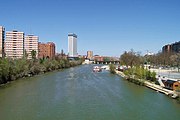
After Langa de Duero, the Duero ceases to be from Soriano and becomes a stretch of Burgos. Aranda de Duero is an important ford of the Duero. In Roa the Duero forms an open curve towards the south, leaving the inhabited nucleus to its right. Shortly before, the Riaza river entered from the left, which takes the name of Riaza in the highlands of Segovia, close to the river source, at the foot of the Quesera pass in the Carpetanos mountains. A few kilometers later, the Duero enters Valladolid, near Peñafiel, where its castle dominates the Duratón River, another tributary that comes from the Central System. From Peñafiel, the first important ford is that of Tudela de Duero. After the Valladolid meridian, the Duero receives the waters of the Cega from the left and shortly after those of the Pisuerga from the right at the height of Geria. Between both confluences is Puente Duero, another of the traditional river crossings.
At the height of Aniago, the Adaja empties into the Duero, which was joined shortly before by the Eresma. A few kilometers further on is Tordesillas, another important ford that has been used since ancient times, over which today the Northwest highway (A-6) from Madrid to La Coruña crosses. Up to Castronuño the river maintains the same direction; Before, the waters of the Zapardiel and Trabancos rivers entered it from the left, which come from the Sierra de Ávila, where they are born very close to each other. In Castronuño, the Duero leaves the direction of the Pisuerga and rises sharply towards Toro. Between both points the Hornija river and the Bajoz river flow to the right, which are minor tributaries originating in the Torozos mountains, leaving the border of the province of Valladolid with the province of Zamora between the two channels.
International Duero or Arribes del Duero
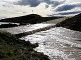
In this area the river is of a storm regime and its average flow ranges between 212 m³/s and 490 m³/s. Upon arriving in Zamora and Salamanca, in the border area with Portugal, the Duero fits into the granitic materials of the Paleozoic, narrowing its channel and descending abruptly 400 m of slope, up to just over 200 m of altitude (4 m/km), are the so -called Arribes del Duero. Here, a little further south of Ricobayo, he receives his most caudalous tributary, from the Cantabrian mountain range, the Esla River, which wears more flow than Duero himself at this point. The area is extremely exploited by hydroelectric reservoirs. These are the Spanish reservoirs of Aldeadávila, Almendra (in the Tormes River), Castro, Ricobayo (in the Esla River), Saucelle and Villalcampo, and the Portuguese inch plants of Bemposta, Miranda and Picote.
High Portuguese Duero
In Vila Nova de Foz Côa, in the Valley of the Coa River, the prehistoric rock sites of the Coa Valley, one of the largest outdoor outdoor places of Paleolithic art are located. He was declared a World Heritage by UNESCO in 1998.
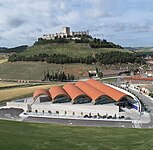
The viticultural region of Alto Duero (Região Vinhateira do Alto Douro) is an area of northeast of Portugal with more than 26,000 hectares, also classified by UNESCO as a World Heritage, in the category of cultural landscape. Alto Duero is totally inserted in the region of Trás -os-Montes and Alto Douro. This region is part of the so -called Viticultural Duero, produces wine more than 2000 years ago, among which is the world famous Porto wine. The long tradition of viticulture produced an exceptional beauty landscape that reflects its technological, social and economic evolution.
mouth
From the mouth of the Águeda River, to the Atlantic Ocean, in Porto, the Duero has a very scarce slope (0.6 m/km), which allows it to be navigable (there are several locks), traditionally by small boats that They transported wine materials of the Country of Vinho ( Rabelos ship (Miranda do Douro) to the ocean. This section is known as the Duero navigation channel. It flows into Porto (Portugal).
Refluents
Its most important tributaries on the right bank are Pisuerga, Valderaduey, Esla, Taste, Túa and Támega. The last three run mainly through Portuguese territory. The taste was born in the Sierra Gamoneda, in the province of Zamora, and the Támega in the Gallego de Laza municipality passing, among others, through the town of Verín before entering Portuguese lands.
Pisuerga is especially known for its passage through the city of Valladolid. The Carrión, tributary of Pisuerga, does so for the city of Palencia. The Arlanzón, tributary of the Arlanza, which drains into the Pisuerga, runs through the city of Burgos. It is therefore the Pisuerga the main tributary of the Duero by its right margin, which is referred to by a popular saying saying: "Pisuerga carries the water and the owner of fame."
The Valderaduey is going through the municipal terms of: Sahagún, Becilla de Valderaduey, Castroponce, San Martín de Valderaduey, Cañizo and Villalpando. It flows into the right bank of the Duero, at the height of Villagodio, about 3 km from the urban core of Zamora, although within the limits of its municipal term.
Through the city of León, the Bernesga passes, which gives its waters to the Esla. It is the most caudalous tributary of the Duero River, carrying in its mouth more caudal than the Duero himself, and of which the saying also exists: "The Esla carries the water and the Duero the fame."
El Pisuerga in Valladolid

The Esla
in Riaño
The Sabbath
embalmed
The Tua in
Look at it.
The Thames in Chaves


.jpg)

Its most important tributaries on the left bank are the Riaza, the Duratón, the Adaja, the Zapardiel, the Tormes, the Huebra and the Águeda.
The Riaza and Duratón rivers stand out for forming two large protected areas of great environmental value, such as the Hoces del Río Riaza natural park and the Hoces del Río Duratón natural park. Riaza and Peñafiel respectively, are the most important cities through which they pass.
The Adaja is famous for passing its course at the foot of the walls of the city of Ávila. The Eresma, a tributary of the Adaja, runs through the city of Segovia, located at the confluence of the latter with the Clamores, at the foot of the Alcazar of Segovia.
The Zapardiel is famous for its passage through Medina del Campo and Tordesillas and the constant flooding it had, being quoted by Miguel de Cervantes in his work Voyage of Parnassus saying: «Zapardiel, famous for its fishing".
The Tormes is especially well-known as it passes through the city of Salamanca and gives the title to the book The Life of Lazarillo de Tormes. The Almendra dam, at 202 meters, is the highest in Spain, and gives rise to one of the largest reservoirs in Spain. It constitutes a particular engineering work, since its turbines are capable of transferring the flow from the Duero to the Tormes, when important floods occur in the Duero.
The course of the Águeda is especially notable when passing through the town of Ciudad Rodrigo. Its last stretch forms the natural border between Spain and Portugal. It presents arribes, like the Tormes and the Huebra.

El Riaza in its natural park

The Duraton in its natural park

The Adaja in Ávila
El Zapardiel en Salvador de Zapardiel

The Tormes in Salamanca

The Egg in Barbalos

The Agueda in Ciudad Rodrigo


Reservoirs
| Embalse | Province | Capacity (hm3) | Surface (ha) | Power (MW) |
|---|---|---|---|---|
| Pozo pig | 229 | 2176 | 7 | |
| The Rábanos | 8 | 98 | 4 | |
| San José | 6 | 250 | 0.56 | |
| Villalcampo | 66 | 445 | 206 | |
| Castro | 26 | 180 | 190 | |
| Miranda | 28 | - | 390 | |
| Picote | 63 | - | 180 | |
| Bemposta | 129 | - | 210 | |
| Aldeadávila | 115 | 364 | 1143 | |
| Saucelle | 181 | 589 | 525 | |
| Pocinho | 83 | - | 186 | |
| Valeira | 97 | - | 216 | |
| Régua | 95 | 160 | ||
| Carrapatelo | 148 | - | 201 | |
| Crestuma-Lever | 110 | - | 108 |
Wine production
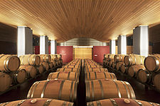
One of the most famous wines in Spain and representative of the Spain Brand in this sector, along with Rioja wines, is that of the Ribera del Duero denomination of origin. At the end of 2005, the crops in the area constituted approximately 2% of all the extension dedicated to the cultivation of the vine in Spain. Some of its best-known wineries are Casajús, Viña Sastre, Vega Sicilia or Protos.
Bodegas Protos

Bodegas Viña Sastre

Bodegas Casajús
Bodegas Vega Sicilia

Bodegas Portia


The same is true of port wine, which the English popularized starting in 1678 when the country went to war with France, leading to a shortage of wine. Since then, numerous British companies have established themselves on the river bank, in the municipality of Vila Nova de Gaia, next to Porto. Noted for its sweet taste and its high alcohol content, which made it strongly resistant to the trip from Portugal to England, it has the White, Ruby and Tawny varieties. Some of its best-known wineries are Taylor, Sandeman, Graham, Ferreira or Vasconcellos.

Bodegas Calém

Bodegas Taylor

Bodega Sandeman

Bodega Graham

Bodega Ferreira
.jpg)
_-i---i-_(28173314689).jpg)


_edited.jpg)
Other denominations of origin that are also located in the Duero plain are those of Arribes, Rueda, Tierra del Vino de Zamora and Toro.
Contenido relacionado
Provinces of Argentina
Soviet Union space program
Pontius Pilate