
Don river
The River Don (Russian: Дон), "river" in the Scythian language, is a river in European Russia that flows through the southwest of the great European plain draining into the Azov Sea. It is 1,870 km long (6th longest in Europe) and drains a basin of 425,600 km² . It is the same river Tanais (Τάναϊς in ancient Greek), from the classical Greco-Roman sources.
The main cities in its course, with more than 100,000 inhabitants, are Voronezh, Volgodonsk and Rostov-on-Don. Its main tributaries are the Donéts and Jopior rivers, both of which are over 1000 km in length. Administratively, the river flows downstream through the following oblasts: Tula, Lipetsk, Voronezh, Rostov, and Volgograd.
Geography
Features
The Don River has all the characteristics of a plain river. Its mean slope varies little from source to mouth, with a value of only 0.1 ‰ ( 10cm/km). It runs through vast alluvial plains throughout its length, except in the vicinity of Kalach-on-Don, where its valley narrows significantly. The Don Valley, like that of other rivers in the region, presents an asymmetric morphology, with the right banks high and steep, and the left banks low and flat.
Course
The Don River rises near the city of Novomoskovsk (134,081 inhab. in 2002), in Tula Oblast, about 50 km southeast of Tula (481,216 inhab.), and about 200 km southeast of Moscow. It initially runs in a southerly direction, receiving the first of its important tributaries, the Nepravda River, from the left and leaving the Tula Oblast along the tri-border between the Tula, Lipetsk and Ryazan Oblasts, into which the river does not enter.
Continuing south, it enters the Lipetsk Oblast, passing through the towns of Dankov (23,249 inhabitants) and Lebedian (22,966 inhab.), to then receive the Krasivaya Mecha River on the right and then the Sosna River, which has just crossed the city of Yelets (116,726 hab.). It follows the Don through Zadonsk (10,500 pop.) and Kon-Kolodej, then reaches a stretch where the river forms the natural border between the oblasts from Lipetsk and Voronezh.
After this short stretch, the Don enters the Voronezh Oblast on its northern side. Keeping in a southerly direction, the river passes very close to the capital Voronezh (848,700 inhab.) (about 12 km), where it receives the Voronezh River from the left and the Devica River from the right. It continues south, passing through the town of Grenjacez and receiving the Potudan river on the right and later the Tichaja Sosna river. It then reaches the city of Liski (55,893 inhab.), to then receive, on the left, the Ikorec river, the Bitiug river and then the Osered river. It continues through the city of Pávlovsk (26,365 inhab.) and then receives, on the left, the Chórnaya Kalitvá river, a point where the river turns towards the E-SE, and where it is less than 50km from the Ukrainian border. The river runs through a section where it receives the Boguchar River from the left and then the Tolucheevk River from the right.
It soon leaves the Voronezh Oblast and enters, on its western side, the Rostov Oblast, a short stretch in which it receives the Peskovatka River on the left and then reaches the towns of Kazankaya and Veshenskaya (< span style="white-space:nowrap">9317 hab.). It then enters the Volgograd oblast, to shortly receive, on the left, the Khoper river and then the Medveditja river. A few kilometers downstream it passes Serafimovich (9939 hab.), then meets the long Ilovlya River (358 km and a basin of 9250 km²) and reaches Kachalino. The Don turns southwest again, flowing through an increasingly arid and dry region, and just before reaching Kalach-on-Don (26,882 hab.), the river enters a dammed area, the tail of the long reservoir of the Tsimlyansk Dam (2700 km²), located more than 200 km distance downstream. In this large reservoir, the Don receives, from the right, the rivers Donskaja Carica, Esaulovskij Aksái and Kurmoyarsky Aksái; and, to the left, to the Liska River and the Chir River. Halfway through the reservoir, the Don River leaves Volgograd Oblast and enters Rostov Oblast again, this time through its east-central part.
Left behind the dam, in the vicinity of the city of Volgodonsk (165,994 pop.) and Tsimlyansk (15,444 inh.), the river continues in a westerly direction, passing through Konstantinovks (18,801 inh.) and into Ust-Donecki It receives from the right the most important of all its tributaries, the Donets River. In its final section, it receives, from the left, the Sal River and the Manych River, and, from the right, the Aksái River, in the town of Aksái (38,012 hab.). It then reaches Rostov-on-Don, the main city along its entire course (1,068,267 inhab.) and shortly after the Don River, after a journey of almost < span style="white-space:nowrap">2000 km, empties into the Sea of Azov forming a wide estuary of about 540 km², very near the eponymous town of Azov (82,090 inhab.).
Maps

Map in Russian del Don.

El Don on a map of Russia.


In the first map the names of the following cities can be read along its course: Новомосковск (Novomoskovsk), Данков (Dankov), Задо́нск (Zadonsk), Воронеж (Voronezh), Ли́ски (Liski), Па́вловск (
History
According to the Kurgan hypothesis, the Don Valley would be the homeland of the Proto-Indo-Europeans, a people imprecisely located to the north between the Black Sea and the Caspian Sea, precisely there. In ancient times, the Don River was considered the border between Europe and Asia (two of the three parts of the world, with Libya—Africa—the third, separated from Asia by the Nile River). In the Book of Jubilees, the river is mentioned as part of the boundary, from its westernmost point to its mouth, of the allotments to the sons of Noah, Japheth (north) and Shem (south). It is mentioned that its course was so fast that it had never frozen. According to Plutarch and Eustathius of Thessaloniki, the Greek name derived from the gift Dan scythe.
During the time of the ancient Scythians it was known, in Greek, as the Tanais River (Τάναϊς), and has been an important trade route ever since. Tanais appears in ancient Greek sources as the name of the river and of a Sarmatian city (Tana-Azaq, present-day Azov), located to the south of its mouth, in the region of the Meotid lagoon (Μαιῶτις λίμνη). The name derives, however, from the Scythian Iranian Dānu 'river', similar to the modern Ossetian don 'river'.
The Khazarian fortress of Sarkel was used to dominate this point in the Middle Ages.
In modern times, the lower reaches of the river saw heavy fighting during Operation Uranus, one of the turning points of World War II.
The Don has given its name to the Don Cossacks, the Cossacks who settled its fertile valley in the 16th and 17th centuries. In modern literature, the Gift is a central theme in the works of Mikhail Sholokhov, writer and Nobel laureate. His most famous work is titled The Gentle Gift. The writer lived in the Vyoshenskaya stanitsa.
Dams and canals
At its easternmost point, the Don River passes very close to the course of the Volga River, in the vicinity of Kalach-on-Don. In 1952 the Volga-Don canal was opened, which, after 101 km, allows one to reach the Volga near Svetly Yar and then, downstream, to reach the Caspian Sea, being one of the main fluvial arteries. The water level of the Don River in this area is reached thanks to the Tsimlyansk dam, completed in the same year, which forms the long reservoir of the same name.
In the following 130 km below the Tsimlyansk Dam, sufficient water depth in the Don River is maintained by a sequence of three dams and Lock systems: the Nikolayevsky class of locks (Николаевский гидроузел), the Konstantinovsky class of locks (Константиновский гидроузел) and the best known of the three, the Kochetovsky class of locks (Кочетовскийр). The Kochetovsky Lock, built in 1914–1919, doubled in 2004–2008, is located 7.5 km below the confluence of the Seversky Donets River in the Don, and 131 km upstream of Rostov, is the Kochetovsky lock. This facility maintains a sufficient water level, both in its section of the Don, and in the lower section of the Severski Donets. This is the last lock on the Don; Downstream of Kochetovsky, the depth necessary for river navigation is maintained by dredging.
The Don River is navigable for most of its course.
Hydrology
The Don River has a plain snow regime. The river begins to freeze in late November or early December. It remains under the ice 140 days a year in the upper course and from 30 to 90 days in the lower course, in the lower part it is never frozen.
| Don's average monthly rate at Razdorskaya hydrological station (1891–1984) (Data calculated in 93 years, in m3/s, for a spillover basin 378 000 km2) |
 |
Gallery
Birth of the Don in Novomoskovsk (Tula)
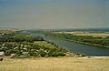
The Don River in Kalininsky (Rostov).

The river Don in Polibino (Lípetsk).

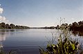
The river Don in the oblast of Voronezh.
Don River near Yeléts (Lípetsk).

The river Don in the oblast of Voronezh.

Don River in Rostov del Don.


.jpg)


River system of the Don River
The Don River has numerous tributaries, the most important of which, following the river downstream, are those listed in the following table.
| Ramal | Affluent name | Destroying | Distance to the mouth | Place of mouth | Length (km) | Cuenca (km2) | Caudal (m3/s) | Federal subjects that go through | Tram. | ||||
| - | D | Nepravda River | Rio Don | 1809 | 67 | 799 | Higher Course | ||||||
| - | D | Tuzlov River | Rio Don | km | 187 | 4660 | 2.1 | ||||||
| - | D | River Krasivaya Mecha | Rio Don | 1645 | Waters under Lebetan | 244 | 6000 | 30.2 | |||||
| - | D | Rio Sosná | Rio Don | km | 296 | 17 400 | |||||||
| I | - | Río Vorónezh | Rio Don | 1403 | 342 | 21 600 | |||||||
| - | - | - | River Lesnoj Voronezh | Río Vorónezh | - | - | |||||||
| - | - | - | Rio Pol'noj Vorónezh | Río Vorónezh | - | - | 178 | ||||||
| - | - | - | Rio Stanovaja | Río Vorónezh | - | - | |||||||
| - | - | - | Río Matyra | Río Vorónezh | - | - | 180 | 5180 | 11.7 | ||||
| - | - | - | Rio Usman | Río Vorónezh | - | - | 151 | 2840 | |||||
| - | D | Rio Potudan | Rio Don | 1317 | 100 | 21 800 | |||||||
| - | D | Rio Tichaja Sosna | Rio Don | km | 161 | 4350 | 5.9 | ||||||
| I | - | Rio Ikorec | Rio Don | km | 97 | 1630 | 1.5 | ||||||
| I | - | Rio Bitiug | Rio Don | 1197 | 379 | 8840 | 18.2 | ||||||
| I | - | Río Osered | Rio Don | km | 89 | 2420 | 1.2 | ||||||
| I | - | Chernaja Kalitva River | Rio Don | km | 162 | 5750 | 124 | Middle Course | |||||
| I | - | Río Boguchar | Rio Don | km | 101 | 3240 | |||||||
| I | - | Peskovatka River | Rio Don | km | |||||||||
| - | D | Tolucheevk River | Rio Don | km | |||||||||
| I | - | Khoper River | Rio Don | 893 | 980 | 61 100 | 150 | ||||||
| - | - | - | Vorona River | Khoper River | - | - | 454 | 13 200 | 41.5 | ||||
| - | - | - | Buzuluk River | Khoper River | - | - | 314 | 9510 | 36 | ||||
| - | - | - | River Savala | Khoper River | - | - | 285 | 7720 | |||||
| I | - | Rio Medveditja | Rio Don | 792 | Waters above Serafimóvich | 745 | 34 700 | ||||||
| - | - | - | Rio Balanda | Rio Medveditja | - | - | 164 | 1900 | |||||
| - | - | - | Archeda River | Rio Medveditja | - | - | 167. | ||||||
| I | - | Ilovlya River | Rio Don | 604 | 358 | 9250 | 9.6 | ||||||
| - | D | Rio Donskaja Carica | Rio Don | km | Inferior course | ||||||||
| I | - | Rio Liska | Rio Don | km | |||||||||
| - | D | Río Chir | Rio Don | km | 317 | 9580 | 12 | ||||||
| - | D | Esaulovskij Aksay | Rio Don | km | |||||||||
| - | D | Kurmoyarsky Aksay River | Rio Don | km | |||||||||
| - | D | Rio Donets (or Seversky Donets) | Rio Don | 218 | Ust-Donetsk | 1053 | 98 900 | 200 | |||||
| - | - | - | Oskol River | Rio Donets | - | - | 436 | 14 680 | |||||
| - | - | - | Korocha River | Rio Donets | - | - | |||||||
| - | - | - | Vovchia River | Rio Donets | - | - | 92 | ||||||
| - | - | - | Río Aïdar | Rio Donets | - | - | 264 | 7240 | |||||
| - | - | - | Rio Udy | Rio Donets | - | - | 164 | ||||||
| - | - | - | Rio Derkul | Rio Donets | - | - | |||||||
| - | - | - | Kalytva River | Rio Donets | - | - | |||||||
| I | - | Rio Sal | Rio Don | 165 | 798 | 21 300 | 9.9 | ||||||
| - | D | River Aksay | Rio Don | 134 | 79 | ||||||||
| I | - | Rio Manych | Rio Don | 99 | 219 | 21 300 | |||||||
Other less important tributaries are the Tsimla (Цимла) (186 km) and Kumshak (Кумшак) (121 km) rivers.