
Department of Potosi
The department of Potosí is one of the nine departments into which Bolivia is divided. Its capital and most populated city is the homonymous Potosí, famous for its deposits of precious metals, which transcended the thesaurus or the lexical heritage of the Spanish language with the sentence vale un Potosí.
It is located in the southwest of the country, bordering to the north with the departments of Oruro and Cochabamba, to the east with the departments of Chuquisaca and Tarija, and to the south with the Argentine Republic up to the trifinio cerro Zapaleri, where its border begins with the Republic of Chile, to the west.
According to the last official census carried out in 2012, the department has a population of 828,093 inhabitants. The density is 7.7 inhabitants/km², being the third least densely populated department —ahead of Beni and Pando—. The department was founded on January 23, 1826 by the marshal of Ayacucho Antonio José de Sucre.
Administratively, the department of Potosí is made up of 16 provinces, which in turn are divided into 42 municipalities. The municipality of Potosí is the most populous with a population of 191,302 inhabitants, concentrating 23.10% of the total departmental population. Other municipalities also of importance due to the amount of population they have are the following respectively: Llallagua, uncia Tupiza, Villazón, Colquechaca, Betanzos, Cotagaita, San Pedro de Buena Vista and Uyuni.
The economy of the Department of Potosí is among those that have had the greatest economic expansion in recent years, since it has traditionally been characterized as a mineral-producing department, which has allowed it to become the fifth largest departmental economy of the country —after Santa Cruz, La Paz, Cochabamba and Tarija.
According to official data from the National Institute of Statistics of Bolivia, in 2016 the economy of the entire Department of Potosí (Gross Domestic Product) reached US$ 2,096 million dollars, which represents 6.16% of the Total Economy of Bolivia (34,053 million). In terms of income per inhabitant (GDP per capita), the department closed 2016 with an average of US$ 2,399 dollars for each person from San Luis Potosí.
History

The original peoples, who inhabited the territory of the current department of Potosí, developed an advanced culture, as evidenced by the numerous existing archaeological sites: the cave paintings of Betanzos, the lithic workshops of Nor and Sur Lípez, and in numerous places more.
In total there are 312 archaeological sites throughout the department.
The first Spaniard to set foot in the current department of Potosí was the unfortunate Diego de Almagro (1536), who previously touched the city of Tupiza today.
In 1545 the Spanish founded the city of Potosí, which in barely a century became an opulent city of more than 150,000 inhabitants, whose fame traveled the world.
The extraordinary progress of the city brought with it profound social transformations in the region, many of them negative. Within a radius of 500 km around, thousands of indigenous people were subjected to the mita and encomienda (quasi-slavery systems), entire populations were uprooted, and thousands of human beings were exploited to death.
It belonged to the Viceroyalty of Peru until 1776, when the region was incorporated by the Spanish Crown into the new Viceroyalty of Río de la Plata.
By the early 19th century, Potosí's wealth was only a distant memory, but that didn't stop the royalists from Upper Peru and the patriots from Buenos Aires will fiercely dispute the region. And although the independence forces achieved the resounding triumph of Suipacha, the royalist victories of Vilcapugio and Ayohúma meant that the current department of Potosí was definitively separated from the Río de la Plata region (present-day Argentina).
The department was constituted on the basis of the former Intendancy of Potosí of the Royal Audience of Charcas, by Supreme Decree of January 23, 1826, issued by the marshal of Ayacucho Antonio José de Sucre.
In 1883, as a consequence of the War of the Pacific, the department of Potosí became a border with Chile. During the course of the 20th century, through various treaties, the border with Argentina was established. The administrative division of the department evolved until it currently has 16 provinces.
On November 7, 1908, American outlaws Butch Cassidy and the Sundance Kid were killed in a confrontation with police in the town of San Vicente, about 100 km northwest of Tupiza.
On November 7, 1908, American outlaws Butch Cassidy and the Sundance Kid were killed in a confrontation with police in the town of San Vicente, about 100 km northwest of Tupiza.
During the course of the XX century, the decline of mining, added to the political vicissitudes of Bolivia, made hundreds of thousands of people from Potosi leave the department in search of better opportunities in Cochabamba, La Paz or neighboring Argentina. In recent years, some mining operations, plus the development of tourism, have revived hopes for an economic recovery.
On June 24, 1967, the day of San Juan Bautista, under the orders of General René Barrientos, government troops committed the largest massacre of workers in the history of Bolivia in Catavi, called the San Juan massacre.
In 2001, violent confrontations broke out between ayllus in northern Potosí and southern Oruro, over resource control disputes and other rivalries, which left 57 dead.
Currently the Department of Potosí has a border dispute with that of Oruro over the city of Coroma or Corama, rich in limestone deposits.
Geography
The geography of the Department of Potosí is characterized by the presence of geysers, fumaroles, volcanic mud, hot water springs and sulfur deposits.
The aggressive landscape of the Western Cordillera is tempered by the presence of lagoons and valleys nestled between the mountains.
The department's climate is cold, except for the valleys between the mountains, which have a temperate climate.
One of the coldest areas in Bolivia is the Salar de Uyuni, the largest salt flat in the world where the temperature drops to –20 °C in winter. The highlands are characterized by low rainfall (100-200 millimeters per year). The Department of Potosí has a cold arid climate (BWk) predominantly and followed by the cold semi-arid climate (BSk), according to the Köppen climate classification..

Relief
The relief of the department is characterized for being mostly mountainous, with a large plateau and for having a large number of valleys with very diverse microclimates.
Among its most important elevations is Uturuncu, which with its 6008 m s. no. m. is the 12th highest mountain in Bolivia. Also noteworthy are Sairecabur (5971 m a.s.l.), Cerro Lípez (5929 m a.s.l.), Licancabur (5920 m a.s.l.) and Cerro Putana (5890 m a.s.l.).
In the southwest of the department is Cerro Zapaleri (5653 m a.s.l.), which marks the tripoint between Bolivia, Argentina, and Chile.
Hydrography
The department has rivers that flow towards the three basins of the country: to the Amazon, through the Caine and Chayanta Guadalupe rivers; to that of the Plata, with the rivers Pilcomayo, Motaca, Tumusla, etc.; and to the closed basin of the altiplano, with the Márquez River, which flows into Lake Poopó, and the Grande de Lípez River, which flows into the Salar de Uyuni. It also has other minor courses that form small lagoons such as Laguna Colorada and Laguna Verde.
In recent years Bolivia has made plans to take advantage of the waters of the Silala springs, in the province of Sur Lípez, in order to produce electricity and for other uses, which has caused friction with the Chilean government.
Flora and fauna

Despite the desert environment that characterizes the department, there is a remarkable biodiversity, which is manifested in numerous species that have managed to adapt to the harsh climate and scarcity of resources in the area.
The flora includes cactaceous species. The vegetation increases towards the extreme northeast, adjacent to the Department of Chuquisaca, a region at a lower altitude and better irrigated by the rains.
Among mammals, camelids (vicuñas, llamas and alpacas) stand out, as well as rodents (vizcachas), felines (pumas) and other species. Among the birds, the condor stands out, which inhabits the high peaks, and the flamingo, very abundant in the lagoons of the altiplano.
Some of these species are in danger of extinction, due to indiscriminate hunting and lack of control by the authorities.
In the Department of Potosí, two protected areas have been created in order to preserve the native flora and fauna of Bolivia. They are the Eduardo Abaroa Andean Fauna National Reserve, located in the extreme south of the department, adjacent to Chile and Argentina, and the Toro Toro National Park, in the extreme north, on the border with the Department of Cochabamba.
Administrative division
The administration of the department resides in the Departmental Government. The municipalities are in turn administered by the Municipal Government. The department of Potosí is divided into 16 provinces, which are in turn divided into 41 municipalities.

| Province | Capital | Surface at km2 | Population | Municipality | Population |
|---|---|---|---|---|---|
| Alonso de Ibáñez | Sacaca | 2170 | 29 821 | ||
| 1 Sacaca | 22 470 | ||||
| 2 Caripuyo | 9875 | ||||
| Antonio Quijarro | Uyuni | 14 890 | 37 431 | ||
| 3 Uyuni | 18 632 | ||||
| 4 Here. | 14 121 | ||||
| 5 Porco | 6412 | ||||
| Bernardino Bilbao | Arampa | 640 | 10 850 | ||
| 6 Arampa | 2648 | ||||
| 7 Acasio | 2899 | ||||
| Charcas | San Pedro de Buena Vista | 2964 | 41 651 | ||
| 8 San Pedro de Buena Vista | 33 892 | ||||
| 9 Toro Toro | 11 919 | ||||
| Chayanta | Colquechaca | 7026 | 98 946 | ||
| 10 Colquechaca | 39 442 | ||||
| 11 Ravelo | 23 044 | ||||
| 12 Little. | 23 430 | ||||
| 13 Ocurí | 23 187 | ||||
| 14 San Pedro de Macha | n/a | ||||
| Cornelio Saavedra | Betanzos | 2375 | 61 398 | ||
| 15 Betanzos | 41 043 | ||||
| 16 Chaquí | 10 290 | ||||
| 17 Tacobamba | 13 875 | ||||
| Daniel Campos | Llica | 12 106 | 5270 | ||
| 18 Llica | 5554 | ||||
| 19 Tahua | 5769 | ||||
| Enrique Baldivieso | San Agustín | 2254 | 2006 | ||
| 20 San Agustín | 2006 | ||||
| José María Linares | Puna | 5136 | 50 817 | ||
| 21 Puna | 41 583 | ||||
| 22 Caize D | 9566 | ||||
| 23 Ckochas | 4311 | ||||
| Modesto Omiste | Villazón | 2260 | 41 124 | ||
| 24 Villazón | 41 124 | ||||
| Nor Chichas | Santiago de Cotagaita | 8979 | 32 946 | ||
| 25 Cotagaita | 23 850 | ||||
| 26 Vitichi | 9649 | ||||
| Nor Lipez | K | 20 892 | 11 594 | ||
| 27 K | 11 763 | ||||
| 28 San Pedro de Quemes | 1088 | ||||
| Rafael Bustillo | Unice | 2235 | 75 599 | ||
| 29 Unice | 25 790 | ||||
| 30 Chayanta | 15 456 | ||||
| 31 Llallagua | 34 898 | ||||
| 32 Chuquiuta Ayllu Jucumani | 5662 | ||||
| South Chichas | Tupiza | 8516 | 47 005 | ||
| 33 Tupiza | 37 208 | ||||
| 34 Atocha | 7795 | ||||
| South Lipez | Saint Paul of Lipez | 22 355 | 5284 | ||
| 35 Saint Paul of Lipez | 2694 | ||||
| 36 San Antonio de Esmoruco | 2330 | ||||
| 37 Mojinete | 694 | ||||
| Tomás Frías | Potosí | 3420 | 189 978 | ||
| 38 Potosí | 166 102 | ||||
| 39 Tinguipaya | 30 842 | ||||
| 40 Yocalla | 8645 | ||||
| 41 Urmiri | 2664 |
Demographics
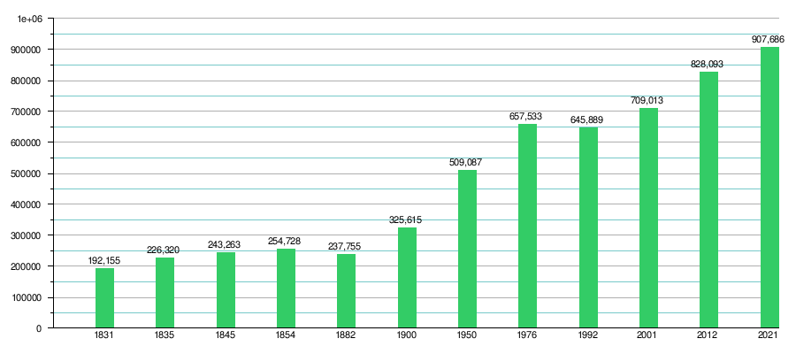
| Historical population Department of Potosí | |||
|---|---|---|---|
| Year | Inhabitants | Source | Ref. |
| 1831 | 192 155 | Bolivian Census 1831 | |
| 1835 | 226 320 | Bolivian Census 1835 | |
| 1845 | 243 263 | Bolivian Census 1845 | |
| 1854 | 254 728 | Bolivian Census 1854 | |
| 1882 | 237 755 | Bolivian Census 1882 | |
| 1900 | 325 615 | Bolivian Census of 1900 | |
| 1950 | 509 087 | Bolivian Census 1950 | |
| 1976 | 657 533 | Bolivian Census of 1976 | |
| 1992 | 645 889 | Bolivian Census 1992 | |
| 2001 | 709 013 | Bolivian Census 2001 | |
| 2012 | 828 093 | Bolivian Census 2012 | |
| 2021 | 907 686 | INE estimates | |
| History of the demographic evolution of the Department of Potosí (According to population censuses and 2021 projection) |
|---|
 |
National representation
| Census | Pobl. Bolivia | Pobl. Potosí | % in relation to the country |
|---|---|---|---|
| 1976 | 4 613 419 | 657 533 | 14,25 |
| 1992 | 6 420 792 | 645 889 | 10,06 |
| 2001 | 8 274 325 | 709 013 | 8,57 |
Population censuses carried out in the last 40 years reveal that the population of the department of Potosí has decreased in relation to that of the national total. In 1976, Bolivia had 4,613,419 inhabitants, of which 657,533 corresponded to the department of Potosí, equivalent to just over 14% of the total. This share decreased to just over 10% in 1992, and to 8.5% in 2001.
Poverty and the lack of job opportunities pushed thousands of inhabitants of the department to seek better horizons in other departments of the country and even abroad, mainly in Argentina.[citation required ]
The population is unevenly distributed. Most of the inhabitants reside in the eastern half of the department, at a lower altitude and with a milder climate.
The cold and inhospitable western provinces -Campos, Nor Lípez, Sur Lípez and Baldivieso- although they occupy 48.7% of the departmental area, have only 23,975 inhabitants, that is, 3.24% of the total of the population.
Languages
The languages spoken in the department are mainly Quechua, Spanish and Aymara.
The following table shows the number of those who belong to the recognized group of speakers.
| Language | Department | Bolivia |
|---|---|---|
| Quechua | 514,421 | 2,281,198 |
| Aimara | 57.738 | 1,525,321 |
| Guaraní | 374 | 62.575 |
| Another native | 356 | 49,432 |
| Spanish | 438,204 | 6,821,626 |
| Aliens | 3,771 | 250.754 |
| Native only | 226,967 | 960.491 |
| Natives and Spanish | 301,280 | 2,739,407 |
| Spanish and foreign | 136.980 | 4,115,751 |
| extra | extra | extra |
Main Cities

The main cities of the department, according to INE projections for 2009, are the following:
- Potosi (120 102 inhabitants), capital of the department. Famous worldwide for its spectacular development in the seventeenth century thanks to the extraction of silver. Declared a World Heritage Site by UNESCO, for its enormous architectural and historical wealth. It is the economic, political and cultural center of the department.
- Llallagua (25 166 hectares), important mining and commercial center.
- Tupiza (37 209 hectares), important agricultural and commercial center, tourist with important mining companies within its jurisdiction. With pleasant climate, fauna, flora, customs and culture that differ from the rest of the department.
- Uyuni (21 440 inhabitants), important tourist centre, railway, commercial and mining. and strategic point for the development of the country due to the fact that in the region of the south-west Bolivia there is the largest salt flat in the world and with this the lithium reserves.
- Villazón (61 511 hectares), active center of trade, on the border with Argentina.
Economy

Mining is the department's main economic activity. Although the silver deposits that made the region famous are now totally depleted, the subsoil still holds numerous mineral riches. There are deposits of antimony, lead, zinc, bismuth, tungsten, sulfur, borax, common salt, lithium, copper, gold, and possibly uranium.
Attempts have been made to industrialize the different metals that are extracted from the subsoil, the most important of which was the Karachipampa project, but with mixed results.
Some farms are run by foreign companies. For example, the San Cristóbal mine, a producer of silver, zinc and lead, was developed by Apex Silver Mines Limited of Colorado (United States), which sold the mine to the Sumitomo Corporation of Japan in November 2008.
In recent years, departmental authorities have placed high hopes in the exploitation of lithium, of which the Salar de Uyuni is known to contain enormous reserves. This mineral is used in the manufacture of batteries and cell phones.
| Economy size of the Department of Potosi (GDP) Average watering per inhabitant (PIB per Capita) | |||
|---|---|---|---|
| Year | GDP (in dollars) | GDPper Capita (in dollars) | Growth Departmental GDP |
| 1988 | US$ 283 million | ||
| 1989 | US$ 302 million | + 4.27 % | |
| 1990 | US$ 293 million | + 5.86 % | |
| 1991 | US$ 291 million | + 5.18 % | |
| 1992 | US$ 311 million | + 2.53 % | |
| 1993 | US$ 278 million | + 4.13 % | |
| 1994 | US$ 286 million | - 5.25 % | |
| 1995 | US$ 326 million | + 0.94 % | |
| 1996 | US$ 365 million | + 4.41 % | |
| 1997 | US$ 376 million | + 0.99 % | |
| 1998 | US$ 374 million | - 0.5 % | |
| 1999 | US$ 391 million | + 6.14 % | |
| 2000 | US$ 400 million | + 4.88 % | |
| 2001 | US$ 376 million | - 2.42 % | |
| 2002 | US$ 361 million | + 3.87 % | |
| 2003 | US$ 382 million | + 6.16 % | |
| 2004 | US$ 426 million | + 2.69 % | |
| 2005 | US$ 434 million | + 2.77 % | |
| 2006 | US$ 633 million | + 4.16 % | |
| 2007 | US$ 715 million | + 12.87 % | |
| 2008 | US$ 1 074 million | + 24.25 % | |
| 2009 | US$ 1 195 million | + 8.02 % | |
| 2010 | US$ 1 415 million | - 0.63 % | |
| 2011 | US$ 1 795 million | + 4.44 % | |
| 2012 | US$ 1 599 million | - 7.06 % | |
| 2013 | US$ 1 693 million | + 5.57 % | |
| 2014 | US$ 1 806 million | + 4.40 % | |
| 2015 | US$ 1 835 million | + 3.92 % | |
| 2016 | US$ 2 105 million | + 7.49 % | |
| 2017 | US$ 2 484 million | + 1.28 % | |
| 2018 | US$ 2 627 million | + 4.11 % | |
| 2019 | |||
| 2020 | |||
| Note: In red, the years of decrease of GDP 0% Down. In green, the years of Regular growth of GDP 0% and 4,50%. In blue, the years of Good growth GDP 4.50% up. Source: National Statistical Institute of Bolivia INE(2019) | |||
| Departments of Bolivia according to the size of their economy GDP (gross domestic product) in 2018 | |||
|---|---|---|---|
| Position | Department | Gross Domestic Product | Comparable country in GDP |
| 1.o | US$ 11 811 million | Guinea | |
| 2. | US$ 11 319 million | Moldova | |
| 3.o | US$ 6 037 million | Eritrea | |
| 4.o | US$ 3 204 million | Suriname | |
| 5.o | US$ 2 627 million | Bhutan | |
| 6.o | US$ 2 071 million | Central African Republic | |
| 7. | US$ 2 030 million | Cape Verde | |
| 8. | US$ 1 104 million | Grenada | |
| 9. | US$ 373 million | Micronesia | |
| Total | Bolivia | US$ 40 581 million | Tunisia |
| Source: National Statistical Institute of Bolivia INE(2019) | |||
| Departments of Bolivia for average inhabitant wealth (gross domestic product per cup) in 2018 | |||
| Position | Department | GDP per Capita | Comparable country per capita GDP |
| 1.o | US$ 5 689 | Iraq | |
| 2. | US$ 3 926 | El Salvador | |
| 3.o | US$ 3 849 | Indonesia | |
| 4.o | US$ 3 663 | Cape Verde | |
| Average | Bolivia | US$ 3 589 | Bolivia |
| 5.o | US$ 3 243 | Morocco | |
| 6.o | US$ 3 062 | Philippines | |
| 7. | US$ 2 961 | Ukraine | |
| 8. | US$ 2 593 | Egypt | |
| 9. | US$ 2 359 | Honduras | |
| Source: National Statistical Institute of Bolivia INE(2019) | |||
| Samples of different rocks and minerals obtained from the 20th century mine, in the town of Llallagua, Rafael Bustillo Province | |||||||
 |  |  |  |  | |||
| Quartz | Vauxita | Bismuto | Wawelita | Copper | |||
 |  | -130888.jpg) |  |  | |||
| Wurtzita | Paravauxita | Monacita | Paravauxita | Metavauxita | |||
 |  |  |  |  | |||
| Vauxita | Paravauxita | Vauxita | Vauxita | Casiterita | |||
 | -196016.jpg) |  |  |  | |||
| Vauxita-Paravauxita | Monacita | Metavauxita | Silver | Silver | |||
 |  |  |  |  | |||
| Estibina | Paravauxita | Quartz | Wawelita | Pirita | |||
Agriculture is sparse and mostly for the local market. Tuber crops (potato) predominate and then there are quinoa, oca, wheat, barley, grapevine (in the Turuchipa valley, province of José María Linares), fruits, vegetables, broad beans, peas, legumes and vegetables. But Potato crops constitute the bulk of local production, with the risk that the population has little variety in their diet.
Livestock is of little importance, although in some isolated populations it is the main form of livelihood for its inhabitants. Both native species (camelids) and introduced species (sheep, cattle, goats and, to a lesser extent, donkeys, horses, pigs and poultry) are raised. Almost half of the production of camelids is destined to the sale of their by-products (meat and sale of fiber, for the textile industry). It is also used as a means of transportation.
In the departmental capital, Potosí, and in the main urban centers, a large part of the population is employed in the service sector: commerce, banks, education, health, security, etc. In recent years, tourism has gained great importance in the department. Numerous inns have been built, and more and more people are working directly or indirectly in this area. But the activity also encounters problems with the infrastructure (bad roads, lack of trained personnel) and on the other hand, some warn that massive and disorganized tourism could have negative effects on the historical heritage of the area.
Transportation
Terrestrial
The roads that run through the department are mostly unpaved, and work to improve them is progressing slowly. The road network, in general, leaves much to be desired.
The best highway in the department is the one that connects Potosí with the city of Uyuni, route 5, completely paved and very well signposted, in the same way with the constitutional capital of the country, Sucre. Route 1 goes to Oruro (and therefore, to La Paz). Route 6 passes through the north of the department, connecting Sucre with Oruro and passing through towns such as Coata, Uncía and Llallagua.
Route 5 goes to Chile, which passes through Uyuni and reaches Ollagüe, on the border with the trans-Andean country, where it connects with Chilean route 21, which reaches Calama.
Route 14 goes to Argentina, which reaches Villazón, and connects, in Argentine territory, with Route 9, in the direction of San Salvador de Jujuy and other capitals of Argentine provinces.
Route 21 enters the department of Oruro and passes through Uyuni, Tupiza and reaches Villazón on the border with Argentina.
Roads generally have three exits D.Z.
Aerials
The Joya Andina airport in the city of Uyuni receives flights from La Paz, Sucre and Rurrenabaque. The Capitán Nicolás Rojas airport, in the city of Potosí, is not entirely adequate. There are also landing strips in Villazón and Uncía.
Railroads

A branch connects the city of Potosí with Sucre, to the northeast, and with the Río Mulato, to the west. In this town, the railway connects with the central line from Oruro to Uyuni, and from here to the west Chile on the Pacific coast and to the south, which in the town of Villazón connects with the General Belgrano Railway, from Argentina.
The Potosí-Río Mulato section is one of the highest railways in the world, only minerals transit. while the Oruro-Uyuni-Villazón railway is used mainly for passenger transport. These lines are operated by the company Ferroviaria Andina.
Contenido relacionado
Annex: Annual table of the 3rd century
Eduardo Boza Masvidal
10th century BC c.