
Department of La Libertad (Peru)
La Libertad is one of the twenty-four departments that, together with the constitutional province of Callao, make up the Republic of Peru. Its capital and most populated city is Trujillo. It has 2 World Heritage Sites declared by Unesco: the Río Abiseo National Park in 1983 and Chan Chan in 1986. It is the national leader in the agro-export sector and in gold production. And it is the second department with the most voters according to the JNE by 2021. And with a population of more than two million Liberteños by 2020. It has the second largest vehicle fleet in Peru.
It is located in the northwest of the country. It limits to the north with the department of Lambayeque, the department of Cajamarca and the department of Amazonas; to the east with the department of San Martín, to the southeast with the department of Huánuco, to the south with the department of Áncash and to the west with the Pacific Ocean.
Its population according to the 2017 census was 1,778,080 inhabitants. It is one of the most populated departments —behind Lima and Piura— and with 63.4 inhabitants/km², the third most densely populated, behind from Lima and Lambayeque. It was created as a department on February 12, 1821. And with a population of more than 2 million Liberteños as of 2020.
La Libertad was the territory of several important civilizations of ancient Peru. Around the I century a. C. the Moche culture arose on the coast, famous for its ceramic art, and in the Sierra, the Cajamarca culture. The department knew the Huari influence and in the Late Intermediate period it knew the expansion of the Chimú Empire throughout the north coast and the influence in the highlands of the kingdom of Huamachuco, in turn related to the kingdom of Cuismanco. This department was later annexed to the Inca Empire and then to the Spanish crown.
During the times of Spanish colonization, the city of Trujillo was founded, which exercised great influence in the north of the country as an administrative headquarters of political, economic and ecclesiastical importance.
When Viceroy Toledo on December 22, 1574 reorganized the corregimientos de indios (or natives), which had been created by Governor Lope García de Castro in 1565, he ordered that the corregimientos of Cajamarca, Chicama and Chimo or Chiclayo, Piura and Paita, Santa, and Saña depended on the Spanish corregimiento of Trujillo and the corregimientos of Cajamarquilla, Los Pacllas, and Luya and Chillaos depended on Chachapoyas. All in the district of the Royal Audience of Lima. In 1611 Los Pacllas was annexed to Chachapoyas, in 1635 Chicamo or Cliclayo was annexed to Saña and in 1773 Luya, Chillaos and Lamas was annexed to Chachapoyas.
On March 24, 1614, the Bishopric of Trujillo was established with the corregimientos of: Trujillo, Cajamarca, Cliclayo, Piura and Paita, Saña, Cajamarquilla, Los Pacllas, Luya and Chillaos, and Jaén de Bracamoros. In 1759 the corregimiento of Huamachuco was formed from that of Cajamarca.
The corregimientos were abolished in 1784, by King Carlos III and replaced by the municipalities. With the territory of the Bishopric of Trujillo (except Jaén de Bracamoros) the Intendancy of Trujillo was created. The corregimientos happened to be parties of the intendancy.
The system of intendancies was established in the Viceroyalty of Peru by means of the royal order of August 5, 1783, being applied the Royal Ordinance of Intendants of January 28, 1782. The first intendant of Trujillo was Fernando de Saavedra, who he assumed office in 1784, appointed by the viceroy at the proposal of the inspector general Jorge Escobedo y Alarcón and approved by the king on January 24, 1785.
It was part of the Municipality of Trujillo that came to have nine parties that were Trujillo, Lambayeque, Piura, Cajamarca, Huamachuco, Chota, Moyobamba, Chachapoyas, Jaén and the General Command of Maynas (made up of the current departments of San Martín, Ucayali and Loreto), being the Municipality of Trujillo the largest in the Viceroyalty of Peru, that is, almost all of northern Peru today; its first mayor was Fernando Saavedra from 1784 to 1791. After him, Vicente Gil de Taboada (1791-1805 and 1810-1820), Felice del Risco y Torres (provisional) (1805-1810) and the Marquis of Torre Tagle would follow. (1820), who led the independence of the Intendancy.
In the Republic, the coast of Libertad was home to the most important sugar mills in the country, destroyed and set on fire by the Lynch Expedition. Also, the War of the Pacific ended in La Libertad with the battle of Huamachuco in 1883.
Currently, La Libertad is the main economic center in the north of the country.
Etymology
The name of La Libertad was named by law on March 9, 1825, recognizing it as "the first place where independence was proclaimed, and the refuge of patriots on two different occasions" and being the capital "the point where the Libertador the famous campaign". Previously it was called the department of Trujillo.
Geography
Location
La Libertad is located in the northwestern part of Peru. To the north it limits with the Department of Lambayeque; to the south with the Department of Áncash and with the Department of Huánuco; to the east, with the Department of San Martín and the Department of Cajamarca; to the west with the sea of Grau. Like oasis in the desert, its coastal valleys are fertile, just like the inter-Andean ones. This department extends to the east, with territories bathed by the mighty Marañón River. Its beaches also have great marine wealth thanks to the Humboldt current (or Peruvian current). In addition, La Libertad is the only department of Peru that covers the three natural regions, Coast, Sierra and Selva, and exit to the sea.
- South Latitude: 6° 56 ́ 38"
- Western longitude: Between meridians 79° 27 ́ 9" and 79° 41 ́ 18".
| Northwest: | North: | Northeast: |
| West: |  | This: |
| Southwest: | South: | Sureste: |
Hydrography
Because the Andes crosses the department, it has three of Peru's four hydrographic basins: the Pacific basin and the Atlantic basin.
On the Pacific slope, the Chicama River stands out. Together, these rivers irrigate the desert coast of La Libertad and allow the development of agriculture. On the Atlantic slope, the rivers flow to form part of the Amazon basin. The most important river that flows through this area is the Marañón, which forms, together with the Ucayali river, the Amazon.
Regarding the coastline, being bathed by the Humboldt current allows the abundance of zooplankton, highly appreciated by different fish, such as anchoveta and bonito.
Islands
- Chao Islands are three North (0.35 ha), Centre (3.75 ha) and South (11.23 ha). The highest is the South Chao with 78 m. n. m. Located 3.22 km southwest of Chao tip.
- Corcovado Island, with an area of 3.75 ha, with a length of 288 m, width of 205 m and maximum altitude of 45 m. It is located 6.4 km northeast of the Infiernillo tip.
- Guañape Islands are two islands called North (34.87 ha) and South (26.17 ha). The highest is the South Guañape with 143 m. n. m. Located 16 and 20 km west of Compositan pampa. In the Southern Guañape there is a lighthouse.
- Isla la Viuda, located 3 km from Viru beach, is a small island of 12 m. n. m.
- Macabi Islands are two islands called North (1.99 ha) and South (5.79 ha). The highest is Macabi Norte with 31 m. n. m. There's a lighthouse on the South Macabi.
Climate
The coastal zone and the Andean zone have opposite climatic seasons simultaneously.
The coastal strip of the department has a warm and sunny climate during a good part of the year. Its average temperature ranges between 20 °C and 21 °C and in the summer of 2017 it exceeded 30 °C. In winter, small drizzles moisten the coastal countryside. In Trujillo, the climate is more humid and cold during a large part of the year. Drizzles and mists are daily phenomena in winter and autumn. These climatic changes in the city are due to the violent change, from desert to cultivated areas, in the area of Chavimochic, pollution is also an important factor.
Its Andean sierra area, and from 3000 m above sea level, has a dry and temperate climate during the day and rather cold at night. During the months of January to March there is a winter of intense rains in this area.
Ecological Regions
| Regions of La Libertad | |||||||
 |  |  | |||||
| Litoral trujillano. Costa | Andean Landscape of Huamachuco. Sierra | Yanasara, Andes de La Libertad. Sierra / Selva | |||||
The existing ecological units in La Libertad are classified into three regional theses:
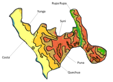
- Traditional classification: This classification is based on the one made by Pedro Cieza de León in 1553, it remains useful but is not enough since the Spaniards only distinguished three regions: coast, mountain range and jungle. It is the only department in Peru that has the three regions.
- Classification in 8 regions: Based on the ranking of Javier Pulgar Vidal in 1945, taking as reference the weather, altitude, flora and fauna. These are (chala or costa, yunga, quechua, suni, puna, cordillera, jungle high and jungle low or Amazon). From these proposed regions, La Libertad has: chala or costa, yunga, quechua, suni and high jungle.
 Regions of La Libertad

- Classification in 11 eco-regions: It was proposed by Antonio Brack Egg; this classification is similar to the previous eight regions but new and complex divisions are added: the cold sea of the Peruvian current, the Pacific desert and the equatorial dry forest. These three are the ones that also exist in La Libertad.
History

In this department, remains of the first most important pre-Hispanic groups of the northern zone have been found. Great civilizations such as the Mochica culture occupied the Moche, Chicama and Virú valleys from the III to the VIII d. C.. Realist ceramics belonged to this period, famous for its "huaco retratos"; the so-called "huacas" are also located, demonstrating the great knowledge of architecture.
From 12th century to XV after Christ, the region witnessed the boom achieved by the Chimú culture with its capital Chan Chan (Sol Sol), which was the largest adobe metropolis in pre-Hispanic America and second in the world. This civilization also stood out for its excellent work in metals, mainly gold, and for its advanced agricultural techniques, embodied in extensive networks of aqueducts. The Incas, after meeting strong resistance, managed to conquer this kingdom in the 14th century.
La Libertad is one of the richest departments in terms of its archaeological heritage, due to its artistic manifestations expressed in ceramics, goldsmithing and polychrome wall decoration.
Among the many testimonies we can mention the imposing (architecture) of Pacatnamu in the limits where the provinces of Chepén and Pacasmayo join; the tomb of a priestess from San José de Moro, in the province of Chepén; the remains of Puemape in the province of Pacasmayo; the Cupisnique cemeteries, the El Brujo complex in the province of Ascope and the Markawamachuko Archaeological Complex in the province of Sánchez Carrión.
The Mochica culture stood out for its realistic ceramics representing human figures and localized fauna and flora; and for its temples in the form of truncated pyramids that show an advanced architecture. After this culture, the Chimús settled, having Chan Chan as their capital, being the largest adobe city in the American continent. Its advanced goldsmithing and architecture with notable networks of aqueducts that are still used for irrigation are part of the cultural and structural heritage of the Chimú culture. At the end of 1534, with the arrival of the Spanish in the valley, Trujillo was founded, receiving the title of city in 1537, becoming one of the main cities of the viceroyalty by becoming one of the richest areas in the north, as witness the beautiful and stately houses that are still preserved. In the same way, the city of Trujillo stands out for its social, cultural and economic importance since colonial times, observing the large lots, palaces (Casona Tinoco) and churches that are still preserved in its historic center. Trujillo is, from colonial times to the present, the most important metropolis in the north of the country, highlighting its important participation in the Peruvian independence process. Trujillo was the first city in northern Peru that declared its independence on December 29, 1820.
During the Chilean invasion, the battle of Huamachuco was fought as a corollary to the La Breña campaign. There Colonel Leoncio Prado was captured and shot.
Early settlers (10,000 BC)
In the La Libertad Region there are the following first settlers:
- The Man of Paiján:
The oldest remains of the presence of man in La Libertad are found in the settlement of the Paijan man, located between the valleys of Virú and Pacasmayo, Paiján influenced with his lithic technique as far as Piura to the north and Ica to the south, This influence is what is called the Paijense tradition. In 1975, the French archaeologist Claude Chauchat discovered the skeletal remains of a child and a woman buried 10,000 years ago in the Pampa de Paiján. Radiocarbon studies gave it a greater age than the Lauricocha skeletons discovered by Augusto Cardich in 1959. Thus, it becomes the first fossil remains of the Peruvian coast (18-year-old boy, 40-year-old woman, and food). The Paijan archaeological complex is the most important on the north coast due to its influence and territorial extension. The archaeological complex is made up of open-air camps, quarries and workshops. It is not yet known exactly to which chronological rank Paiján belongs. Two human remains have been found that after analysis with carbon 14 give a date of 8000 years BC. C., however the projectile points found suggest the hunting of large animals that were no longer found on the coast in the year they were dated. It is believed that the Paiján man initially had a predilection for hunting, but as the years went by, and when he observed the facilities that fishing gave him, he turned his gaze to the sea, this being his greatest source of resources from the 5000 BCE c.
- The Man of Huaca Prieta::
Discovered by Junius Bouton Bird in Chicama belongs to the pre-ceramic period with an antiquity of 4500 years; sedentary man who cultivated pallares, pumpkins, chili peppers, squash, achira. He built half-buried cubicles, with small stone walls and whale bones. They practiced the “pachamanca”, the “asado”. A fabric was found with the representation of a condor and a pyrography mate considering him the first weaver of Peru.
Cupisnique and Chavín influence in La Libertad (800 BC - 200 AD)

Cupisnique developed between 800 B.C. C. and 200 AD. C. on the coast of La Libertad from Virú to the department of Lambayeque, its ceremonial architecture is characterized by having low rectangular platforms with enclosures in the upper part and front patio, "u"-shaped constructions and circular platforms with sunken patios, It was a purely coastal culture that developed parallel to the Chavín culture.
Cupisnique pottery shows a possible Chavín influence since they are very similar. Regarding the use of semiprecious stones, they used it to make necklaces, amulets, rings, earmuffs and even little idols.
Among the main archaeological centers found in La Libertad, from this culture are: constructions made of adobe and stone as shown in the Moche valley in the Pyramid of the Kings (dead horse complex) as well as adobe sculptures and bas-relief decorations on the walls and columns of the building. The Cupisnique deities can be seen in the pyramid of the kings, so it can be said that they had anthropomorphic deities that are represented as half man and half animal with faces with fangs and menacing eyes.
The Chavín culture discovered by Julio C.Tello who called it “matrix culture” had its center in the province of Huari in the Department of Áncash, its influence in La Libertad was between 1300 to. C. and 200 d. C. that is demonstrated in the ceramics and archaeological remains found in the Andes of La Libertad that show a clearly Chavín style.
The Moche "golden expression of art " (200 AD - 600 AD)

The Moche developed between the years 200 AD. C. and 600 d. C. in La Libertad, its main center was located in the Chicama valley, its influence reached from the south to the Santa River and from the north to present-day Piura. Its origin not yet defined shows an affinity with the Cupisnique and Chavín.

Their constructions were complex buildings such as the Pyramids of the Sun and the Moon that had ceremonial and administrative purposes; They also built aqueducts developing an advanced Hydraulic Engineering that allowed them to develop an important agricultural economy with the Ascope and La Cumbre aqueducts, which are still useful to this day. The great development of this culture is shown in art such as ceramics that represent the way of life of the Moche society expressed in scenes of war, religion, fishing, hunting, sexual practices and the daily life of the Moche settler as well as representations of animals and plants; In the wall decoration you can also see the Moche worldview that shows their frightening gods such as Aiapæc.

Metallurgy is also one of the most outstanding expressions of the Moche that takes it to the highest level of technological sophistication in Peru and the pre-Hispanic world for its time. In the Jequetepeque valley in San José De Moro, the remains of a priestess were found whose function was to reach the cup containing the blood of those sacrificed to the bird warrior, Lord of Sipan.
At a social level, the Moche were divided into social classes, with two supposed dominions arising, one to the north of the Jequetepeque river and the other to the south of it, it was during the hegemony of the latter that around 500 AD. C. the Moche ruled from the Piura valley to Huarmey.
The Moche decline came with the expansion from the south of the Wari empire from the Department of Ayacucho around 600 AD. C. putting an end to 400 years of Moche rule on the Costa de la Libertad, which would then return as if to be reborn 200 years later with similar characteristics reflected in the Chimú.
The Wari in La Libertad (600 AD - 900 AD)
They developed between 500 AD. C. to 900 d. C. in the province of Huari in the Department of Ayacucho this empire included La Libertad around 600 AD. C. they founded cities "head of the Region" that allowed a decentralized government to have the best control and domain. In freedom, the city of Huiracochapampa located in Huamachuco, Sánchez Carrión stands out.
The religion of the Wari was evoked to the god of the sticks or the staffs. The Wari decline probably came with the invasion by the Yarovilcas or the invasion of the Chancas around AD 900. C., ending the Wari empire in La Libertad and the Middle Horizon in Peru.
The Chimú "Kingdom of Tacainamo" (1100 AD - 1470 AD)

The Chimú developed between 1100 and 1470 AD. C. being located in the same territory that the Mochicas occupied two centuries before, its extension was from the Department of La Libertad to the department of Tumbes to the north and the Chillón river to the south in Lima. The main center was located in Chan Chan next to the current departmental capital, Trujillo; Chan Chan was a fortified city made of adobe considered the largest mud city in the world, it is composed of palaces and citadels among them: Cahyhuac, Uhle, Gran Chimú, Velarde, Squier, Badelier, Laberinto, Rivero and Tschudi (the most preserved).
Legend tells that Tacaynamo was the founder of this kingdom who had arrived in a boat from the ocean to teach them how to do agricultural and artistic work; This scene is represented in ceramics and shows the inhabitants in boats made of reeds like the famous "caballito de totora" very characteristic of La Libertad.
The Chimú had two stages, in the first they were located only in the valley of the Moche river while in the second an expansive impulse prevailed. It is believed that it had ten rulers but only four are known: Tacaynamo, Guacricur, Naucempinco and Minchancamán. The Chimú language was varied depending on the area, but Muchik prevailed.

Around the year 1470, the Inca empire had conquered numerous territories. He had conquered Cajamarca through the northern sierra, the Chinchas and Chuquimanco through the south coast; The only thing missing was the north coast, which was under the power of a powerful monarch, whom the Cuzco people called Chimú Capac Minchancaman, who was very arrogant and proud.
Chimú Capac was not willing to give in the slightest to the Inca's claims, who asked him to be his faithful vassal, since he considered himself superior to Pachacutec, thus began one of the great rivalries of the pre-Hispanic world, the most powerful monarchs of the time began a long war of attrition, from which the one with the most firmness and reservations would survive.
Pachacutec entrusts Inca Yupanqui with the conquest of that rich and fertile territory that the Inca longed for. So they prepared an army of thirty thousand men to start the annexation of this territory. The first encounter was in Paramonga, where the Incas and Chimús fought for many days. Here the Chimús fought fiercely, without having the slightest intention of giving in to the Inca power. After measuring forces in the first confrontations, the temporary victory is for the Chimus who expelled the Inca expansive intentions. Before this defeated Tupac Yupanqui asks for reinforcements from Pachacutec, and support from Shankas and; the later arrival of old enemies of the Chimus (Cuismanco and Chuquismanco), reinforcing the Inca troops that they lost at the beginning, gave a turn to the situation, which forced the Chimus to withdraw from this valley towards Huarmey. In honor of this first and great Inca triumph, Tupac Yupanqui ordered the modification and expansion of part of the Paramonga temple, from that moment this great monument would remain as a memory of the Inca greatness and victory over Minchancaman, Chimú monarch. Likewise, Antonio de la Calancha says that in this first valley the deaths in combat were 6,000 for both parties, the prince being forced to ask for help.
The decline of the Chimú kingdom came in the middle of the XV century AD. C. during the government of the last king of the Chimú, Minchancamán; It happened before the Chimú resistance to be invaded by the Inca Empire and its allies under the command of the son of Pachacútec, Túpac Yupanqui; This Inca emperor had the canal system that allowed the Chimú to irrigate their fields cut, so part of the Chimú kingdom gave in, however, Minchancaman, who was arrogant and proud, was the last to give in to the conquered Inca, contracting nuptials with one of the sisters of the Inca Tupac Yupanqui sealing the conquest before the Inca emperor who continued his conquest in northern Peru. Which, Minchancaman is taken to Cuzco along with nobles and Chimús soldiers, when he married the sister of the Inca Tupac Yupanqui was frowned upon by the Cuzco nobility, being assassinated in Cuzco, giving the imminent result of the fall of the Inca Empire later.
The succession of the territory governed by Minchancaman during the time of the conquest of the Inca Empire, was held by the son of Minchancaman and Chanquirguanguan, lady of the Huaura valley, Chumun Caur, who was put in his place and married a daughter of Pachacútec. The new Chimú ruler ruled with the support of Querrotumi, his father's lieutenant during the war, who would rise up in 1475 but would be defeated and commit suicide on Mount Campana.
Decades later, when Huayna Cápac was in Quito, a rebellion broke out and Chan Chan was burned down and its canals were destroyed. The royal family, headed by his grandson Huamán Chumo, was banished. After this most of his people abandoned it and the population was reduced to five or ten thousand people. When the Spanish arrived in 1534 it was a shadow of its past.
Freedom in the Inca Empire (1470 -1535 AD)

The Inca Empire arrived in La Libertad around 1470 AD. C. during the government of the son of Pachacútec, the emperor Túpac Yupanqui in the decline of the Chimú kingdom during the government of the last king of the Chimú, Minchancamán; It happened before the Chimú resistance to be invaded by the Inca Empire and its allies under the command of the son of Pachacútec, Túpac Yupanqui; This Inca emperor had the canal system that allowed the Chimú to irrigate their fields cut, so part of the Chimú kingdom gave in, however, Minchancaman, who was arrogant and proud, was the last to give in to the conquered Inca, contracting nuptials with one of the sisters of the Inca Tupac Yupanqui sealing the conquest before the Inca emperor who continued his conquest in northern Peru. Which, Minchancaman is taken to Cuzco along with nobles and Chimús soldiers, when he married the sister of the Inca Tupac Yupanqui was frowned upon by the Cuzco nobility, being assassinated in Cuzco, giving the imminent result of the fall of the Inca Empire later.
The succession of the territory governed by Minchancaman during the time of the conquest of the Inca Empire, was held by the son of Minchancaman and Chanquirguanguan, lady of the Huaura valley, Chumun Caur, who was put in his place and married a daughter of Pachacútec. The new Chimú ruler ruled with the support of Querrotumi, his father's lieutenant during the war, who would rise up in 1475 but would be defeated and commit suicide on Mount Campana.
Decades later, when Huayna Cápac was in Quito, a rebellion broke out and Chan Chan was burned down and its canals were destroyed. The royal family, headed by his grandson Huamán Chumo, was banished. After this most of his people abandoned it and the population was reduced to five or ten thousand people. When the Spanish arrived in 1534 it was a shadow of its past.
During the imperial rule La Libertad had no Inca presence; The Chinchaysuyo only made up one of the four suyos of the Inca empire (Tahuantinsuyo). La Libertad included part of the Inca trail that passes through the current Andean provinces of La Libertad; This road came from Huaylas in the direction of Cajamarca, which was part of the Inca roads that linked the imperial capital, Cusco with the city of Quito.
The Inca domain in La Libertad ended when the Spanish arrived and took Emperor Atahualpa prisoner in Cajamarca in 1533, this was consolidated with the founding of Trujillo by Diego de Almagro in 1535, thus culminating in the tiny domain of the Inca empire in La Libertad and the late horizon in Peru. From now on, La Libertad would see the arrival and colonization of new and different inhabitants in the territory that belonged to the Chavin, Cupisnique, Moche, Wari, Chimú and Inca Empire. These would make up the new identity of La Libertad, new customs, new races and a new thought shared by all the peoples of Latin America.
Freedom during the colony

On October 12, 1492 Christopher Columbus discovered America with the support of the Catholic kings of Spain, Fernando de Aragón and Isabel de Castilla; in time many Spaniards would come in search of fortune and fame. In 1524, Francisco Pizarro, Diego de Almagro and the clergyman Hernando de Luque formed a conquering company directed towards the south of Panama. In 1528 they arrived in Peru; In 1533 they arrived in Cajamarca, taking the Inca emperor Atahualpa prisoner. After killing him, the empire fell into the hands of the Spanish.
On December 6, 1535, Diego de Almagro founded the town of Trujillo de Nueva Castilla in honor of the birthplace of Francisco Pizarro (Trujillo, Cáceres, Spain). The city was populated by landowners and gradually acquired a stately spirit that made it one of the most important cities in the viceroyalty of Peru. Regarding the population, it was divided into social classes; the nobility was at the head formed mainly by Spaniards; the middle class made up of Spaniards and Creoles; while the town was formed by the mestizos and the Indians. The landowners were distributed throughout the coast and the Andes of the current department of La Libertad.
When Viceroy Toledo on December 22, 1574 reorganized the corregimientos de indios (or natives), which had been created by Governor Lope García de Castro in 1565, he ordered that the corregimientos of Cajamarca, Chicama and Chimo or Chiclayo, Piura and Paita, Santa, and Saña depended on the Spanish corregimiento of Trujillo and the corregimientos of Cajamarquilla, Los Pacllas, and Luya and Chillaos depended on Chachapoyas. All in the district of the Royal Audience of Lima. In 1611 Los Pacllas was annexed to Chachapoyas, in 1635 Chicamo or Cliclayo was annexed to Saña and in 1773 Luya, Chillaos and Lamas was annexed to Chachapoyas.
On March 24, 1614, the Bishopric of Trujillo was established with the corregimientos of: Trujillo, Cajamarca, Cliclayo, Piura and Paita, Saña, Cajamarquilla, Los Pacllas, Luya and Chillaos, and Jaén de Bracamoros. In 1759 the corregimiento of Huamachuco was formed from that of Cajamarca.
The corregimientos were abolished in 1784, by King Carlos III and replaced by the municipalities. With the territory of the Bishopric of Trujillo (except Jaén de Bracamoros) the Intendancy of Trujillo was created. The corregimientos happened to be parties of the intendancy.
The system of intendancies was established in the Viceroyalty of Peru by means of the royal order of August 5, 1783, being applied the Royal Ordinance of Intendants of January 28, 1782. The first intendant of Trujillo was Fernando de Saavedra, who he assumed office in 1784, appointed by the viceroy at the proposal of the inspector general Jorge Escobedo y Alarcón and approved by the king on January 24, 1785.
It was part of the Municipality of Trujillo that came to have nine parties that were Trujillo, Lambayeque, Piura, Cajamarca, Huamachuco, Chota, Moyobamba, Chachapoyas, Jaén and Maynas, this last party previously made up the departments of what is now known as (Department of San Martín, Ucayali, Loreto) being the Municipality of Trujillo the largest in the Viceroyalty of Peru, that is, almost all of northern Peru today; its first mayor was Fernando Saavedra from 1784 to 1791. After him, Vicente Gil de Taboada (1791-1805 and 1810-1820), Felice del Risco y Torres (provisional) (1805-1810) and the Marquéz de Torre Tagle would follow. (1820), who led the independence of the Intendancy.
During the colony, the San Carlos and San Marcelo seminaries operated in Trujillo, where Toribio Rodríguez de Mendoza, a forerunner of the independence of Peru, studied.
The production was based mainly on agriculture taking a type of feudal economy, animals such as horses, cattle, birds, etc. were also introduced. The architecture is reflected in the construction of churches and mansions found in the main cities, while in the Andean areas houses are built with adobe, wood and clay roofs, typical constructions of the Spanish population in America.

The government was directed from Lima, the capital of the Viceroyalty of Peru, which dominated the entire northern area of present-day Peru. Spanish customs and culture are reflected in gastronomy and art, during the colony they merged with the original ones, resulting in a new identity that was the Hispano-American, whose differences would lead this new sector to seek independence and patriotic identity.
- The Spanish presence in Trujillo:Produced the Spanish conquest, the murder of Atahualpa and the capture of Cusco, Francisco Pizarro provides that Diego de Almagro visits the valleys of the north coast, to know the number of inhabitants and to found new cities, a strategic measure to consolidate the domain on these lands. Diego de Almagro founded Trujillo in late November or early December 1534.This act would be officialized by Francisco Pizarro on March 5, 1535, in which the second foundation is celebrated with the City denomination of "Trujillo de los Reinos de Nueva Castilla". As is known, the name of Trujillo was adopted as a tribute to the birthplace of the conqueror. Trujillo was founded in the lower part of Chimo Valley, a name that comes from the time of the kings of the Chimu Empire. It is worth noting that the right margin of the river Moche is called the valley of Santa Catalina, the left margin, until the height of Cerro Prieto and the Huaca del Sol was known as Valle de Conache. The lower part was named Valle de Santa Lucia de Moche. The first attempts at spatial articulation were made following the Andean communication systems used by Chimús and Incas. The transfer of the capital to Lima and the need to strengthen links with Spain raised the importance of the cities located on the coast. The communication with Spain was carried out by sea. The vessels leaving from Lima had as a destination point Panama along its itinerary gained importance the ports of Santa, Huanchaco and Paita, necessary for the ships to supply water, food, cargo and passengers. The economic movement of these times revolved around the production of Trujillo and its immediate environment: sugar, leathers, cereals, flour and swine. From Trujillo and to Lima and the rest of the country mobilized copper, wine, aguardiente in botijas, wood, cane honey and rice. During these centuries Trujillo was considered the barn of Peru and became the most important city in the Peruvian north. This regional preeminence increased after the destruction of Zaña, as a result of a terrible flood, on March 15, 1720.
 Francisco Pizarro.
- The Spanish presence in Trujillo:Produced the Spanish conquest, the murder of Atahualpa and the capture of Cusco, Francisco Pizarro provides that Diego de Almagro visits the valleys of the north coast, to know the number of inhabitants and to found new cities, a strategic measure to consolidate the domain on these lands. Diego de Almagro founded Trujillo in late November or early December 1534.

Freedom during Independence
Reformist concern was for a long time the desire of many patriots to change the unjust existing colonial system in America. began at the end of the XVIII century as a result of having become aware of the ideal of independence. It was intended to fight against the absolutist system of government, the absence of fundamental human rights, social and economic inequality, forced labor, slavery, abuse, etc. imposed by Spain.

The libertarian ideas coined in Europe at the end of the XVIII century and beginning of the XIX found a positive response in northern Peru and particularly in the population of Trujillo, made up of indigenous, mestizo, Criollo, Spanish and black people, which at that time constituted a powerful cultural, religious, political, social and economic focus. After the landing of General José de San Martín in Paracas, on September 8, 1820, the Marquis of Torre Tagle, mayor of Trujillo since August 24 of that year, led a separatist movement that resulted in the declaration of independence on December 24 in a Cabildo Abierto session and its proclamation on the 29th of the same month. In this way, Trujillo was the first city in the country where the break of dependency with Spain was formally proclaimed.
The importance of Trujillo since the dawn of independence was notable. It had the highest number of representatives to the First Constituent Congress (15 out of 79), installed on September 20, 1822. It was the seat of Congress and the Government of the Republic in the second half of 1823. It was the seat of the First Superior Court of Justice installed by José Faustino Sánchez Carrión, who also created, on May 10, 1824, the National University of Trujillo. On January 31, 1822, he was awarded the title of "Benemérita y Fidelísima a la Patria". The decree of March 9, 1825 changes the name of the city to Bolívar and the Department to La Libertad. By Law of July 21, 1827, the name of Trujillo was restored to the city after the withdrawal of Simón Bolívar from Peru. During his stay in Peru, Bolívar, after leaving Lima, moved to Trujillo and temporarily named it the capital of Peru; also when he was in Huamachuco he officially created the first university of the republic: the National University of Trujillo.
The republican 19th century
The north evolved slowly in economic matters, because the central element of the national economy continued to be the unrestricted exploitation of natural resources: the mineral from Cerro de Pasco and then, in the second half of the century XIX, the exploitation of guano and saltpeter. These events transferred the socio-economic and political weight and gravitation that the north of the country had had towards the center and the south. At the same time, the better geographical conformation and spatial population distribution of the north, with large extensions of cultivated land, a significantly lower altitude mountain range and greater population mobility contributed to the appearance of local economies and the weakening of the role of Trujillo, who, having fulfilled a significant role in colonial times and the beginning of republican life, loses his capacity for agglutination, which translates into the successive dismemberment of ion of its territory. Thus, between 1832 and 1874, the department of Trujillo was created in the departments of Piura (1837) (which in turn gave rise to Tumbes), Amazonas (1932-1935, 1939, later Loreto was split from it, and from this, San Martín and Ucayali), Cajamarca (1855, 1862), and Lambayeque (1874). La Libertad remained, from those dates, practically with the territorial dimension that it has today. In almost fifty years, it lost 90% of the territory it had as an Intendancy and at the beginning of the Republic. The new maritime routes, the Industrial Revolution and technological changes marked the strengthening of the centers located to the south of Callao and the decline of those located to the north. Despite this, the agrarian economy of the coastal valleys began to acquire a more stable appearance with the productive specialization of the sugarcane and cotton areas. In the mountains, the purely agricultural and livestock character of the Cajamarca-Huamachuco axis is consolidated. The period of the war with Chile meant not only paralysis and economic recession. The destruction of capital assets, especially in the haciendas in the north, caused a noticeable drop in the production and exploitation of sugar. As an indirect consequence of the war, ownership of the sugar estates began to be concentrated in a few hands. The export of sugar recovers its level only ten years after the end of the War.
National Reconstruction
It is the period immediately after the war with Chile and where Peru had to rise from the ruins of the unfortunate war, building again the state apparatus, trying to overcome the national debacle. During the government of Nicolás de Piérola, a great impulse was given to the industrialization of coastal agriculture, with a strong presence of foreign capital, turning the land into the property of a few, which gave rise to latifundia for the production of sugar and cotton. This is how the agro-industrial centers of Casa Grande and Cartavio in La Libertad stood out.
Freedom of the 20th and 21st centuries
The beginning of the XX century finds Peru and the Department in a renewed and sustained economic growth in the agricultural field, mainly during the decade that preceded the First World War. Mechanization is introduced, and this makes it possible to incorporate large tracts of arable land on the coast. For these reasons, the north coast began a period of agricultural expansion linked to its subsequent industrialization, which was particularly manifested in the sugar industry. Until the first decade of the XX century, the economic evolution of sugar plantations benefited Trujillo, whose economy, supported by trade, It prospered thanks to the export and import flow that was recorded in Salaverry. The same happened with Ascope in the Chicama Valley, the axis of trade in the valley and the coast- sierra interchange, as it is the main access to Cajamarca. The authorization of Malabrigo meant the suspension of the transfer of sugar to Salaverry and the collapse of the economy of Trujillo. In turn, the economic growth of Casa Grande, the management of imported products and the concentration of plantation ownership, weakened the importance of Ascope, a city that saw its influence disappear with the start-up of The pan-american highway.
The second decade of the century transformed the means of transportation. The Pan-American Highway, which interconnects the local economies of the Coast; and the arrival of air transport, originate the consolidation of the centralist power of Lima, the functional elimination of ports and coves, and the eclipse of cities that were not depending on the new communication circuits. In the following two decades, La Libertad began to acquire its own physiognomy, based on the exploitation of cane and sugar manufacturing, for which the production of the Moche and Chicama valleys constituted the main element in the formation of the GDP, followed by the Quiruvilca mining production (copper, silver and zinc).
The Jequetepeque Valley, especially Guadalupe, specialized in rice, sustained a milling activity to which is added the cement production in Pacasmayo. On the other hand, the Sierra Liberteña, largely cut off from communication, maintained its role as a supplier of bread products to the cities of the coast. An incipient industrialization took place in Trujillo at the end of the 50's, as part of the import substitution model that is applied in the national and South American context. The increase in employment opportunities seen under these circumstances, however, is quickly exceeded by the expectations generated in Chimbote as a result of the boom in anchovy fishing and the production of fishmeal and fish oil. Likewise, the region's agro-export vision is consolidated with the introduction of new products such as asparagus. Industrial activity in Trujillo gives the city, from the 1960s, its own productive dynamics, which it had not had until then. Libertad's capital began to have a defined economic and productive personality.
At the end of the 1960s, the agrarian reform took place, as part of the measures of the military government, with La Libertad being the department that concentrated most of the haciendas, converted into cooperatives, receiving the influence of the positive aspects and, especially negative, of this measure.
In the 1970s and later, Trujillo has consolidated its image as a metropolis, establishing a large range of industrial companies stimulated by the promotional and protectionist policies of the time.
Contemporary Freedom
The XXI century finds La Libertad as a department that consolidates its concertation processes at the departmental and local level, in the context of a rebirth of democracy, the search for institutionality and the renewed impetus of the decentralization process, which allows us to infer that the progressive overcoming of its problems and the coast-Andes dichotomy are challenges that must be faced with effective plans. and concrete proposals in the present and immediate future, so that the beginning of the XXI century definitively consolidates La Libertad as a region in frank concerted development process.
Administrative division
| Provinces of the department of La Libertad | ||||||
|---|---|---|---|---|---|---|
| Ubigeo | Province | Capital | Districts | Surface km2 | Population 2017 | Altitude m. n. m. |
| 1301 | Trujillo | 11 | 1 766.89 | 985 275 | 34 | |
| 1302 | Ascope | 8 | 2 658.92 | 121 266 | 238 | |
| 1303 | Bolívar | 6 | 1 718.86 | 16 553 | 3 098 | |
| 1304 | Chepén | 3 | 1 142.43 | 89 225 | 135 | |
| 1305 | Julcán | 4 | 1 101.39 | 30 588 | 3 412 | |
| 1306 | Otuzco | 10 | 2 110.77 | 92 388 | 2 660 | |
| 1307 | San Pedro de Lloc | 5 | 1 125.26 | 106 019 | 48 | |
| 1308 | Tayabamba | 13 | 4 226.53 | 90 008 | 3 290 | |
| 1309 | Huamachuco | 8 | 2 486.38 | 157 912 | 3 185 | |
| 1310 | Santiago de Chuco | 8 | 2 658.96 | 62 176 | 3 127 | |
| 1311 | Cascas | 4 | 1 284.77 | 31 268 | 1 279 | |
| 1312 | Virtue | 3 | 3 218.74 | 122 623 | 76 | |
| Trujillo | Ascope | Bolívar |
|---|---|---|
 Trujillo • El Porvenir • Florencia de Mora • Huanchaco • La Esperanza • Laredo • Moche • Poroto • Salaverry • Simbal • Víctor Larco Herrera |  Ascope • Chicama • Chocope • Magdalena de Cao Santiago de Cao • Paiján • Rázuri • Cartavio • Casa Grande |  Bolívar • Bambamarca • Condormarca • Longotea • Uchumarca • Ucuncha |
| Chepén | Julcán | Otuzco |
|---|---|---|
 Chepén • Pacanga • Pueblo Nuevo |  Julcán • Calamarca • Carabamba • Huaso |  Otuzco • Agallpampa • Charat • Huaranchal • La Cuesta • Mache • Paranday • Salpo • Sinsicap • Usquil |
| Great Chimu | Pacasmayo | Pataz |
|---|---|---|
 Cascas • Lucma • Marmot • Sayapullo |  San Pedro de Lloc • Guadalupe • Jequetepeque • Pacasmayo • San José |  Tayabamba • Buldibuyo • Chilia • Huancaspata • Huaylillas • Huayo • Ongón • Parcoy • Patáz • Pías • Challas • Taurija • Urpay |
| Sánchez Carrión | Santiago de Chuco | Virtue |
|---|---|---|
 Huamachuco • Chugay • Cochorco • Curgos • Marcabal • Sanagorán • Sarin • Sartimbamba |  Santiago de Chuco • Angasmarca • Cachicadan • Mollebamba • Mollepata • Quiruvilca • Santa Cruz de Chuca • Sitabamba |  Virú • Chao • Guadalupito |
Demographics
- Population:The population in the department of La Libertad is the third largest in Peru, since the number of inhabitants is 1 778 080 inhabitants, representing 6.1% of the Peruvian population, according to the last population census at the national level. It should also be considered that Trujillo the capital city of La Libertad is the third most populous city in Peru and the largest city in northern Peru. The largest population is concentrated in provincial and district capitals, with a signal that it is defined as a majority urban population. The immigrant population in La Libertad is composed of Peruvian citizens from border departments and citizens from other countries.
- Second destination of foreign migrations in Peru: The department of La Libertad is the second destination of the foreign migrations in Peru, since it captures 5.2% of these. Most are from Chile, Argentina, the United States, Colombia, etc. [chuckles]required].
The evolution of the population of the La Libertad Region can be observed in the following graph:
| Figure of the evolution of the population of the Region Freedom between 1940 and 2014 |
|---|
 |
| Sources: Population 1940, 1961, 1981, 1993, 2007, 2014 |
Population
The department of La Libertad has a population of 2,016,771 as of 2020 according to INEI
| Ubigeo | Province | Surface (km2) | Population 2017 | Estimate 2020 |
|---|---|---|---|---|
| 130101 | Trujillo | 1766.89 | 970 016 | 1 118 724 |
| 130102 | Ascope | 2658.92 | 115 786 | 123 480 |
| 130103 | Bolívar | 1718.86 | 14 457 | 15 982 |
| 130104 | Chepén | 1142.43 | 78 418 | 86 411 |
| 130105 | Julcán | 1101.39 | 28 024 | 30 987 |
| 130106 | Otuzco | 2110.77 | 77 862 | 85 091 |
| 130107 | Pacasmayo | 1125.26 | 102 897 | 112 970 |
| 130109 | Pataz | 4226.53 | 76 103 | 85 092 |
| 130111 | Sánchez Carrión | 2486.38 | 144 405 | 168 670 |
| 130109 | Santiago de Chuco | 2658.96 | 50 896 | 55 868 |
| 130109 | Great Chimu | 1284.77 | 26 892 | 28 290 |
| 130109 | Virtue | 3218.74 | 92 324 | 105 206 |
| Total | 25255.96 | 1 778 080 | 2 016 771 |
Religion
During the pre-Hispanic period in the department of La Libertad there were different religions. Among them that of the Moche who had a polytheistic religion whose gods were frightening in appearance with fangs and a face posed with evil, the Chimú had a vision similar to that of the Moche, including anthropomorphic and nature deities.
When the Spaniards arrived, it introduced the Catholic religion, which over time expanded to become the supreme religion of the department, as it did in all of Latin America. Currently, its highest representative in the department is the Archbishop of Trujillo, Héctor Miguel Cabrejos Vidarte.
It is the majority and it is the one that represents the cultural axis of the cities of the department, being reflected in the patron saint festivities that are important celebrations in each population, this consists of venerating and paying homage to the patron saint of the town generally for four days.
With regard to other religions of Christianity, there are several Protestant churches such as Evangelicals, Pentecostals, Adventists and others that have managed to attract numerous followers. There are also small communities of religions such as Judaism, Islam and Buddhism.
Most populated cities
The following is a table with the main cities of the department of La Libertad.
Authorities
Regionals
- 2019-2022
- Regional Governor: Manuel Llempén Coronel, of the Alliance for Progress Party.
- Regional Deputy Governor: Ever Cadenillas Coronel, of the Alliance for Progress Party.
- Counsellors:
- Trujillo:
- David Osvaldo Calderón De los Ríos (Alianza para el Progreso)
- Raúl Yván Lozano Peralta (Peruvian Aprist Party)
- Roberto Luis Portilla Lescano (Alianza para el Progreso)
- Teresita de Jesús Bravo Malca (Alianza para el Progreso)
- Bolivar: Edgar López Chávez (Popular Force)
- Sánchez Carrión: Milagros Jennifer Catalán Corman (Popular Force)
- Otuzco: Gonzalo Alfredo Rodríguez Espejo (Alianza para el Progreso)
- Pacasmayo: Edwin Martín Castellanos García (Alianza para el Progreso)
- Pataz: Luis Alberto Rodríguez Ponce (Alianza para el Progreso)
- Santiago de Chuco: Santos Nicolás Vásquez Ibáñez (National Restoration)
- Ascope: Greco Vladimir Augusto Quiroz Díaz (Alliance for Progress)
- Chepén: Juan Fernando Díaz Sánchez (Partido Aprista Peruano)
- Julcán: Wilson Hitler Rodriguez (New Freedom)
- Gran Chimú: Karin Marly Vergara Portilla (Democratic Party We Are Peru)
- Virtue: Mirtha Margot Higa Urquiaga (Súmate)
Education
Basic
In the department there are 2,908 private and public schools, 718 for initial education, 1,730 for primary education, and 460 for secondary education.
Economy
La Libertad is one of the most important departments of Peru, economically it contributes 6.7% of the country's GDP.
Economic news
The department of La Libertad, former territory of the Moche civilization, now stands as the most attractive place in the country to do business (2010). The economist of the Central Reserve Bank, Alejandro Inga Durango, has stated that La La Libertad Region from 2002 to 2011 has achieved an economic growth of 7.2%, above the Peruvian national average. This growth is due to the entry of mining, such as the case of Barrick Misquichilca, which made the region the second largest gold producer after Cajamarca. La Libertad also stands out for the large presence in its territory of companies oriented towards agro-exports located in agricultural valleys of the region, highlighting those located in the Valleys of Chao, Virú, Moche and Chicama.
Economic performance
The La Libertad Region with its capital, the city of Trujillo, has been consolidating its economic growth with investments and budding projects, aimed at shopping centers and supermarkets, apartment towers and more sophisticated tourist infrastructure. This, fundamentally, is a consequence of the lucrative agro-export and mining activity that makes executives and labor in general from other provinces, and residents of other regions, see the capital of La Libertad as an interesting destination for entertainment and consumption.
Like Trujillo, the region's vernal economic situation stretches along the coastal strip from the agricultural valley of Virú to the rice fields of Chepén, passing through the sugar province of Ascope. In the last two provinces, firms such as Camposol and Empresa Agroindustrial Casa Grande stand out in the Casa Grande district. There, the economic dynamism is also visible in urban improvement works and communication routes sponsored by their own municipalities.
However, the district of Pacasmayo has been relegated, despite the presence of the emblematic Cementos Pacasmayo and its enormous tourist potential, among other aspects for hosting the second longest wave in the world after the port of Chicama (Ascope). Projects for basic services are just being arranged and what prevails is ambulatory commerce.
Chepén is a different case, since its proximity to Lambayeque and important cities of the La Libertad Region such as Pacasmayo, San Pedro de Lloc and Guadalupe allows it to maintain around 21 financial establishments to date, according to Wilfredo Quesquén, its mayor provincial. There, the high presence of municipal and rural banks stands out, such as the Nuestra Gente rural savings and loan bank and the Trujillo Municipal Bank.
On the other hand, mining is considered one of the main economic supports of Lima. The activity is led by Barrick Misquichilca and Pan American Silver, followed by Poderosa and San Simón, among others. However, development is not visible in the jurisdictions where it takes place: whether due to the lack of access roads, the frequency of departures or a lack of transparency in the management of the provincial municipalities, the Sierra Liberteña continues to show the highest rates of poverty and therefore, under commercial development.
Supported by agro-industry, the cultivation of sugar cane and its industrialization stand out in the agro-industrial companies (ex-agrarian cooperatives) of Casagrande, Cartavio, Laredo, etc. It is also worth noting the sustainable and prestigious development of its footwear, incidentally one of the best in the country. Likewise, in La Libertad the planting of asparagus began on the Peruvian coast, being for decades the leading region in its production. Rice planting is significant. The production of pineapple and grapes are growing in importance. They emphasize the breeding of birds, goats and cattle. The most outstanding hydroelectric plant in the region is Pampa Blanca. In mining, it is currently the first gold producer in Peru; in addition, there are important stone coal deposits in Otuzco. Currently there is a 'boom' agricultural exporter in the region. This is due to the Chavimochic Special Project, a great work of hydraulic engineering, which allows desert areas to be cultivated with the direction of rivers through large canals and branches of these. Added to this is the use of irrigation technologies, such as drip irrigation and satellite control. The most produced and exported products are: Asparagus (green, white, etc.), paprika, tomato, artichoke, etc. The metal mechanical industry is also present in the region, with the manufacture of buses for passenger transport. In the period January-July 2007, it presented an increase of 6.6% of its GDP.
Commerce and services
Heir to a commercial dynamic par excellence from his ancestors, the Mochicas, Trujillo is the center of commerce in La Libertad. This is evidenced by the two large landings of shopping centers embodied in the Mall Aventura Plaza (owned by Falabella and Ripley) and the Real Plaza (owned by the Interbank group), both inaugurated in the last three years. Added to this is the Los Jardines Open Plaza power center (owned by Falabella) and the multiplication of supermarkets, among which the emblematic brand Wong stands out, after the takeover of the local chain Merpisa. In addition, the entry of the Metro brand is present, which opened a new supermarket in the Ovalo Papal. Thanks to these ventures, more conspicuous consumer firms as diverse as Ilaria and Starbucks become more accessible to the Trujillo population, who previously had to travel to Lima to access these types of establishments. On the other hand, an obligatory visit in Trujillo, even when it is a fleeting walk, is Avenida España, which in its last blocks concentrates a colorful and diverse offer of footwear made in the city. The coexistence of nine universities and the size of its facilities show that the capital of La Libertad is not only the objective of professional training for many immigrants from other provinces. Likewise, the capital's pre-university academies, such as Pamer, are making their way in the Primaveral city, while private schools are consolidating their offer, which translates into a higher cost of pensions –the highest in the country after those of the schools of Lima–. A separate point, if there is something that characterizes Trujillo it is its good cuisine. Thus, gastronomic clusters are identified for all tastes and pockets. Such is the case of the one located at the intersection of Larco avenue and Francisco Borja street, which houses two grill restaurants, a Norky's, a hamburger restaurant and a pizza wagon.
On the other hand, the offer of services improves through car dealerships, which have increased the proliferation of 4x4 trucks in the city. This probably has to do with the credit approved by one of the 145 offices of financial entities that as of January supported the commercial development of the region, 20.8% higher than the 120 that existed at the end of 2008. As of December 2009, La Libertad registered a growth of 4.59% in direct loans compared to the previous year.
Main products
Among the main products that contribute to the economy of the region are:
- Gold. The La Libertad Region (RLL) is the second gold producer after the Cajamarca region.
- Uva. Cascas has turned the La Libertad region into the first grape producer at the national level.
- Asparagus. Freedom is the first producer at the national level, being one of the main products of libertarian agro-exportation.
- Rice. The region is the third producer of this product at the national level.
- Dad. Freedom is the fourth potato producer at the national level, produced mainly in Otuzco, Julcán and Santiago de Chuco.
- Shot. It occurs mainly in the province of Trujillo, is a product that stands out at the national level.
- Trigo. First wheat producer.
- Cebada. RLL is the first wheat producer.
- Yellow corn. RLL is second producer at national level.
- Sugar spider. RLL is the first sugarcane producer at the national level.
Mining
Mining, since the 70s maintained a presence of the order of 4.5% in the departmental GDP, having reached, however, a relatively high point (6%) at the beginning of the 80s, to decline later and return in the years to their previous levels, due to the national crisis. As of the 1990s, there has been an appreciable increase, due to the rise of gold mining, in which La Libertad ranks second nationally.
This sector, made up mostly of small and medium-sized companies, is particularly vulnerable to fluctuations in the world market. Mining is based in the sierra and ceja de selva areas and its production revolves mainly around silver, lead, zinc, copper and gold.
Departmental mining shares the problem that, in general, has been affecting the national mining sector, above all, with the paralysis of the investment cycle that has not allowed renewing equipment and giving way to more efficient technologies that are less polluting of the environment. The exploration process and new claims have not continued either, due to the lack of geological prospecting studies aimed at valuing the potential. For example, the non-exploitation of the existing anthracite coal deposits in Chicama; the fluctuation of the prices of metals set by the international market. The absence of productive linkages (concentrators and refineries) prevents greater regeneration and retention of added value, maintaining the essentially primary nature of the activity. This even assumes artisan features, such as the small gold exploitation existing in the province of Pátaz and Santiago de Chuco.
Fishery
Fishing activity is concentrated in the ports of Salaverry, Malabrigo and Pacasmayo and more than 95% is oriented towards indirect human consumption (fishmeal and fish oil). Being its contribution to the departmental product of the order of 1.2% since the 1970s, it is worth noting the downward trends of the fishing sector, whose participation has been reduced six times over the last twenty years.
Fluctuating weather conditions directly affect the availability of biomass and, added to the technological characteristics, equipment and infrastructure that companies have, configure the possibilities of the activity: the obsolescence of equipment and difficulties for renovation and technological modernization of its units; landing and conservation infrastructure deficit; and the size and characteristics of the fleet are not adequate for an efficient and profitable operation. The absence of defined policies for technical, credit and training support is felt, especially for artisan activity that has unused potential.
Transportation
- Air: International Airport Captain FAP Carlos Martínez de Pinillos (Trujillo).
- Maritime: Puerto Salaverry, Puerto Malabrigo and Puerto Pacasmayo.
- Terrestrial: Pan-American Highway, among other roads.
- Future project: Interoceanic Ferrovía Salaverry-Leoncio Prado-Frontera Perú-Brazil (FERRIPEB), of the Bioceanic Geopolitic Project Peru - Brazil, with projection to the city of Cruzeiro Do Sul in the State of Acre-Brazil, with Law No. 29613, which states of public necessity and national interest (Projected).
Heritage
Cultural
Pre-Hispanic art
_01.jpg)
The Region of La Libertad is part of a suggestive scenario of nature and landscape, where there are cave evidences whose singular connotations cannot go unnoticed, constituting archaeological testimonies still unknown in our environment, to which the authorization has not been given. due importance, this is how the journalist Gustavo Álvarez Sánchez suggested it in the years of 1974, who proclaimed the need to become aware and the importance of inventorying or having a map of rock art for the region, understood that the crystallization would constitute by itself in an important contribution to accurately locate the existence of cave paintings, Petroglyphs and Geoglyphs, which would place La Libertad in the first place in the north of the country.

The archaeological studies reported to date allow us to have a global vision of an entire evolutionary composition of man, finding traces of occupations dating from 10,000 BC. C. (Paijanense), in whose chronological advance the man was modifying spaces, exchanging experiences and assimilating new modalities, significant to explain that among its integrative elements, they chose temporarily consecrated places within a special order, both for individual and community rituals., supposedly moved in response to some event or natural phenomenon of transcendence, these conceptions were consolidating in societies that had stationary activities. Diverse archaeological testimonies distributed along the slopes and collectors of the Jequetepeque, Chicama, Moche Virú and Santa rivers, mostly between the slopes, where the premise of the hill would be associated with water elements, many of these vestiges temporarily show activity with hydroclimatic changes.

These cave productions understood as material testimonies of the result and the continuous conception and interaction of man with his environment, were sedimenting schemes that would later become an ideological corpus in more advanced societies that followed them. However, its apparent dissociation in terms of graphic representations makes it difficult to date it, being seen roughly as an old tradition that lasted in parallel throughout the various chronological moments. The dialectical changes and singularities are unknown, which as a sacred element allowed communion with the reverential attitudes towards the ancestor and deities that had to mediate with nature, it can be affirmed that these converged in a continuous and renewed set of conceptions adhered to myths and legends. of which today only immutable rocks remain that resist the silence of the years and the enormous distance that separates us from their creators.
The ideographic representations by which man perpetuated his beliefs, reveal the question to be resolved about the function of these rocks, whose surfaces show engravings that are still difficult to decipher because they penetrated and coexisted in parallel with mythology and history. rite, hinting that these were intended to revere their main cosmogonic deities.
Dances
Each year, since 1960, the National Marinera Contest has been held, organized by the Club Libertad de Trujillo at the initiative of Guillermo Ganoza Vargas. This contest is held the last week of January. The marinera is a dance that descends from the zamacueca and the mozamala.
La Marinera norteña is danced as a couple in normally white clothing. The man wears a straw hat and scarf. The barefoot woman wears an embroidered dress.
Natural
Protected areas
- Calipuy National Reserve: Created in 1981, it extends over 60 000 ha in the upper Andean area of the department of La Libertad and is one of the last refuges of the guanaco, a species currently in grave danger of extinction. The guanaco - one of the wild camélidos, along with the vicuña - is also the one that has best adapted to areas of different configuration. This truck abounded in Patagonia and Tierra del Fuego and was a fundamental component of the diet of the Patagonian and Wave Indians. Unfortunately, the population of guanacos has fallen drastically, not only because of the irrational hunting that has been the object - always as a source of meat and skins - but also to the threat that has meant for its subsistence the introduction of sheep in territories that previously belonged to it. Very close to the reserve, one of the largest tracks of the Puya raimondii, also called a Santon, titanka or keshke, one of the rarest plants on the planet. To protect it was established in 1981 the Calipuy National Sanctuary, on a surface of 4500 ha. It grows only on slopes exposed to the sun and on good drainage floors. They say the natural who grows for a hundred years and blooms once. In effect after having flourished, the plant dies.
- Forest and archaeological complex El Cañoncillo, located in the district of San José in the province of Pacasmayo.
Archaeological and historical
Museums
It has several museums, which are located mainly in the archaeological zones and some in the departmental capital, Trujillo. There are other museums located in the provinces that are mainly of a cultural and historical nature. The most important museums in the region are:
- Museo de Arqueología y Antropología de la Universidad Nacional de Trujillo (Trujillo)
- Museum of the Lady of Cao in Magdalena de Cao, Ascope (Province of Ascope)
- Chan Chan Site Museum (Trujillo)
- Huacas de Moche Museum (Trujillo)
- Museo de Zoología Juan Ormea Rodríguez (Trujillo)
- Museum (Trujillo)
- Toy Museum (Trujillo)
- Virgin of La Puerta Immaculate Museum (Otuzco)
- Municipal Museum Huamachuco Huamachuco
- Casa Museo Antonio Raimondi (San Pedro de Lloc)
- Museum of Modern Art (Gerardo Chávez) (Trujillo)
- Museum of Archaeology José Casinelli (Trujillo)
- Chiclín Museum (Chicama)
- César Vallejo Museum (Santiago de Chuco), in the house where Cesar Vallejo lived, are exhibited among other things, the different atmospheres of the house where the outstanding universal poet spent many years of his life, some mentioned in his famous poems.
Ecology
In the capital of the department, Trujillo, the Municipality has implemented a voluntary recycling system in order to separate organic and inorganic waste to give it a new use. In addition, the number of garbage boxes has been increased in strategic areas of the city. In some provinces, recycling and care for the environment is practiced with the support and training of mining or agro-industrial companies that operate in the area, this example can be seen in the provinces of Pataz, Santiago de Chuco and Huamachuco.
Contenido relacionado
New seven wonders of the modern world
Libyan Geography
Iron law of wages