
Department of Ancash
Ancash is one of the twenty-four departments that, together with the constitutional Province of Callao, make up the Republic of Peru. Its capital is Huaraz and its most populated city is Chimbote. It was created on February 12, 1821 under the name of Huaylas. Lima to the south. With 29.6 inhabitants/km², it is the eighth most densely populated department, behind Lima, Lambayeque, La Libertad, Piura, Tumbes, Cajamarca and Ica.
Within the department, there are two types of landscapes: the arid coastal plain that dominates the entire western part of the department with an average maximum width of 15 km, and the mountainous areas, which occupy 72% of the departmental territory and comprise to the geographical features of the Cordilleras Blanca, Negra, Huallanca, Huayhuash, the Sierra Oriental de Áncash and the Cañón del Marañón, areas that together have 20 peaks over 6000 ms. no. m. These mountainous formations give rise to very important rivers such as the Santa and the Pativilca that flow into the Pacific Ocean, the Yanamayo and the Marañón, tributaries of the Amazon. 340,000 hectares of Ancash are made up of three protected natural areas, namely: the Huascarán National Park (World Heritage Site), the Cordillera Huayhuash Reserved Zone and the Yanashallash paleontological site, located in the departmental highlands.
The history of Ancash is linked to the earliest cultural manifestations of Ancient Peru, from the development of Archaic stonework to the XIII century B.C. C., with the man from the Cueva del Guitarrero. It receives the influence of the Caral-Supe civilization; In its territory, where roads to the jungle, coast and mountains converge, the Chavín culture arose and developed, which later influenced the Recuay and Wari cultures. Already in the second half of the XV century it was integrated into Tahuantinsuyo by Pachacútec and Túpac Yupanqui, who consolidated their empire with the construction of 3 branches of the Inca trail to the north. During the Viceroyalty of Peru, its mining and agricultural wealth was used for more than 300 years. Today these economic activities, added to fishing, are the axis of growth in the region.
Ancash has a rich historical heritage, with pre-Columbian archaeological sites such as Chavín de Huantar (World Heritage), Sechín, Yaino or Huilcahuaín. Also a very well preserved section of 50 km of the Inca Trail (World Heritage).
The department is the sixth economy in the country for contributing 3.5% to the national Gross Value Added. The relative importance of the region in the country is greater in the case of the mining, fishing, and manufacturing sectors. 47.8% of the employed population works in the tertiary sector, followed by 37% in the primary sector, and the remaining 15.2% in the secondary sector.
Toponymy
The department had the name of Huaylas between 1835 and 1839, in honor of one of the most important ethnic groups in the region: the Huaylas whose members were close relatives of the Inca Atahualpa during the Tahuantinsuyo. On February 28, 1839, by decree of President Agustín Gamarra, the name of the department was changed to "Áncachs" in reference to a stream near the Pan de Azúcar hill, where the battle of Yungay took place and in which Gamarra participated, forming the ranks of the Chilean-Peruvian army, emerging victorious from that confrontation that was decisive for the dissolution of the Peru-Bolivian Confederation.
The geographical element from which the name “Áncachs” was taken, is a river called by the locals as Anqashmayu, whose meaning is "blue river" (azul=anqash, río=mayu). Already by the beginning of the century XX the current form “Ancash” was used.
Geography
Ancash is located in the Peruvian Norandina region, where it occupies a territory equivalent to 2.8% of the Peruvian territory, a territory similar in size to the island of Taiwan. The Andes cross the Ancasino territory longitudinally from north to south. In its geography, the landscapes of the desert coast, the high Andean mountains and the area of dry forest that is located up to 2300 meters in the canyon of the Marañón river contrast.
It is bordered to the west by the Pacific Ocean and draws its limits to the north with the department of La Libertad through the line formed by the Santa River from its mouth in the sea, to its union with its tributary, the Tablachaca River. The boundary line runs through the canyon formed by the Tablachaca River to the watershed, after which a short tributary of the Marañón River follows. The eastern limit, with La Libertad and Huánuco, is drawn by continuing the Marañón canyon up to meridian 9°22', where it ascends by a short tributary to its left bank. Follow the watershed to deviate at the meridian 9°43' to the east to encompass the district of Huallanca. The line takes the continental divide at the meridian 10°06' by the Cordillera Huayhuash to the meridian 10°16'. From this point, the confused border with the department of Lima is traced to the west, which ends in the ocean near Punta La Litera.
| Northwest: | North: | Northeast: |
| West: |  | This: |
| Southwest: | South: | Sureste: |
Relief
The rugged relief of Ancash is one of the main factors that configures the natural environment. The mountainous alignments and their disposition have a special incidence in the configuration of the climate, the fluvial network, the soils and their erosion, the bioclimatic floors and even in the way of use of the natural resources and the territorial political conformation.
The Ancashino relief is characterized by the strong altitudinal contrast from the coast at 0 masl to the mountains at 6768 m s. no. m. The desert coast makes up almost 30% of the territory; In front of the Andean zones, from 1,000 meters of altitude that begins in the foothills of the Cordillera Negra to ascend to the valley of the Santa River with an average altitude of 2,800 meters above sea level and then rise to 6,768 meters above sea level in the Cordillera Blanca and descend abruptly in the eastern sierra to the Marañón Canyon at 2400 m s. no. m.
.jpg)
- Costa, the coastal strip is characterized by a fairly irregular shore in which they alternate sandy beaches, covets and bays such as Chimbote and Samanco, with a regular appearance of small islands such as White Island, Santa Island, Ferrol Island, Tortuga Island, Redonda Island, Bernardino Island, Corcovado Island, El Bajo Island, Erizo Island, Los Chimús Island, Messiah Island, Moñaque Island.
- It comprises the provinces of Santa, Casma and Huarmey on an area of 10 174.44 km2. In the province of Santa is the fishing port of Chimbote, the largest in the country, which concentrates important part of the national fishing activity, in addition to the main oil processing factories, flour, fish conserves and the steel industry. These provinces share more or less homogeneous environmental and cultural characteristics that fit perfectly into what is called an environmental region; that is, a geographical area in which the relationships between the environment and the forms of human needs satisfaction are similar.
- This region is crossed by the rivers Santa, Lacramarca and Nepeña, in the province of Santa; by the rivers Casma, Sechín and Grande, in the province of Casma; and by the rivers Huarmey and Culebras, in the province of Huarmey. With 3,514 acres in Casma, 14,089 in Huarmey and 28,165 in Santa. The Chimbote-Nepeña-Casma Irrigation Project (Chinecas) is currently being developed, which aims to incorporate some 23,000 hectares of eriace pampas into agriculture.

- Sierra, it is configured in two territories separated by the Cordillera Blanca, the Callejón de Huaylas to the west and the Zona de los Conchucos to the east. The first is a narrow alluvial valley that extends along the course of the Santa River from its birth to the south in Conococha, to the Cañón del Pato to the north, delimited by the Cordillera Negra to the west and the Cordillera Blanca the east, the latter and the Cordillera of Huayhuash to the south, have the highest snows in Peru, the Huascaran (6,768 msnm),
- The area of the Conchucos, on the other hand, is a succession of several rugged valleys whose rivers are tributaries of the Marañón, in this territory the plateaus and punas abound, has rivers of great flow but of short route, such as the Mosna, Puchka, Yanamayo, Acochaca and Pomabamba, all with glacial origin and that pour their waters to the north river,
Climate
The climate of Ancash is varied. From May to September "Andean winter". On the coast, the lower floor of the western slope, the climate is desert, with very little and poorly distributed rainfall, which increases as one advances in altitude; Zones with a temperate and dry climate are found in the middle floors of the eastern and western Andean slopes, as well as in the Callejón de Huaylas; cold and dry climates in the punas and high plateaus; and polar climates in the snowy peaks. To the east of the Cordillera Blanca and at the bottom of the valley formed by the Marañón there is a warm-humid climate, with high temperatures during the day and night.
Hydrography
| Main rivers of Áncash | |||
 | |||
| Name | Length (km) | ||
|---|---|---|---|
| Rio Santa | 347 | ||
| Marañón River | 226(*) | ||
| Rio Pativilca | 154 | ||
| Rio Fortaleza | 114 | ||
| Casma River | 106 | ||
| Rio Huarmey | 93 | ||
| Rio Culebras | 88 | ||
| Río Nepeña | 85 | ||
| Rio Vizcarra | 48 | ||
| (*): Longitude of the Marañón River corresponding to its passage through Áncash. | |||
Glaciers and Snowy Peaks
The two highest mountain ranges in Peru, the Cordillera Blanca and the Huayhuash have more than 200 glaciers in their territory that are distributed, in the Cordillera Blanca, along its 180 kilometers in length, from the snowy Tuco in the south, to the vicinity of the snow-capped Champará in the north. Some 27 glaciers exceed 6,000 meters above sea level and around 200, 5,000 m s. no. m. Most of the rivers originating in the valleys of this mountain range drain into the Santa River basin. The area covered by snow comprises 504.4 km², which represents 14.84% of the total area of the park. There are 712 glaciers representing 486,037 km² and an estimated volume of 18,458 km³ of solid-state hydrological potential.

Arhuay (6.025 / 4.554 m)
Artesonraju (6.025 / 4.685 m)

Llaca (6.123 / 4.500 m)

Pastoruri (5.201 / 5.001 m)


Gaps
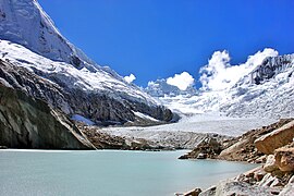
Within the limits of the protected areas of the Huascarán National Park and the Huayhuash Reserve, more than 400 lagoons have been identified, representing an approximate area of 27.7 km². Most of them are of glacial origin. Bathymetric surveys have only been carried out in 40 of them, resulting in a volume of 435,086,656 cubic meters. Among the lagoons, Querococha in Recuay stands out; Pelagatos in Pallasca; Parón in Huaylas; Llanganuco in Yungay; Conococha on the Pativilca-Huaraz highway; Purhuay and Reparin in Huari and Ventanilla in Asunción.

Rivers
The continental divide of the Americas, the dividing line between the waters that flow into the Pacific Ocean and those that flow into the Atlantic, crosses the Huascarán National Park in half continuously. So the two parts have a nearly equal ratio of surface area. There are three main rivers that originate in the park, the Santa River, the Yanamayo River and the Pativilca. The first two run in the same direction from south to north: the Santa receives the contribution of 23 rivers from the Cordillera Blanca, which have their origin In 457 glaciers and flows into the Pacific Ocean, the Yanamayo River receives the contribution of 16 rivers, which have their origin in 192 glaciers and drain into the Marañón River, which flows into the Amazon to flow into the Atlantic. Finally, the Pativilca receives the influx of the Piskaragra River, which has its origin in 14 glaciers and runs from east to west to flow into the Pacific.
| Rio | Length (km.) | Vertient | Birth (altitude) | |
|---|---|---|---|---|
| Santa | 347 | Pacific | Conococha (4,050 msnm) | |
| Marañón | 226 * | Atlantic | Nev. Yapura (5,800 msnm) | |
| Pativilca | 154 | Pacific | Nev. Pastoruri (4,950 msnm) | |
| Fortress | 114 | Pacific | Cordillera Negra (4,900 msnm) |
Islands
- Calvo Island
- White Island
- Isla Caleta de Lobos
- Corcovado Island
- Cornejo Island
- Low Island
- Erizo Island
- Farallón Island
- Ferrol Islands
- Isla Grita Lobos
- Island La Campana
- Island Las Viñas
- Island Los Chimús
- Manache Island
- Island
- Moñaque Island
- Sugar Pan Island
- Isla Patillos
- Redon Island
- Santa Island
- Tortuga Island
Biogeography

Flora
The Andean territory of Áncash has large extensions of eucalyptus and pine forests, the product of reforestation in the 1990s; It is worth noting the presence of other native trees to a lesser extent such as the molle, the tara, the capulí, the quenuales, the quishuar, the walnut, the alder, the willow, the cypress and the broom; the wood from these forests is used for mining, housing construction, and carved wood crafts.
Wildlife
The autochthonous fauna is made up of a multitude of animal species that inhabit the different altitudinal levels around the region. Among the mammals, the weasel, the Andean cat, the spectacled bear, the puma, the taruca, the deer, the vicuña on the highest floors, the vizcacha, the fox, the muca stand out.
There is also a great diversity of birds: birds of prey such as the mountain harrier, the condor, the sutro duck, the mountain duck, the goldfinch, the Andean gull; the coot; the hummingbird, the thrush, the Andean sparrow.
Protected natural areas
Ancash has a large number of natural spaces and ecosystems of great uniqueness and environmental value. Its importance and the need to make the conservation of its values and its economic use compatible, have fostered the protection and management of the most representative landscapes and ecosystems of the Ancasino territory. The Huascarán National Park that occupies 10% of the departmental territory and the Reserved Zone of the Cordillera de Huayhuash that it shares with the department of Lima stand out.
History


Ancash in prehistory and ancient Peru
During the division of the supercontinent Pangea, the eastern territory of Ancash was an immense and dense savannah that bordered a sea that stretched from present-day Colombia to northern Bolivia. This temperate ecosystem on the shores of the sea with large-flow tributary rivers that descended from the original Andes Mountains fostered the proliferation of various species of dinosaurs, which bequeathed an extensive deposit of footprints and fossils in the current south-eastern territory of the park. national, in lands that formed during the Albian stage during the Lower Cretaceous.
The oldest known human settlement in Peru, dated around the middle of the XIII millennium BC. C. (~12,560 BC), is located in Áncash, the Cueva del Guitarrero in the district of Shupluy (province of Yungay). Towards the VII millennium a. C., they had already cultivated and domesticated the first beans (Phaseolus vulgaris), limp beans (Phaseolus lunatus), chili peppers (Capsicum sp.), ollucos (Ullucus tuberosus), rhizomes and Andean fruits. They had a fairly varied diet based on the natural resources of the region that also allowed them to learn about plants to make various utensils.
The development of horticulture and monumental architecture in the basins of the Chuquicara (Pallasca) and Santa (Callejón de Huaylas) rivers discovered in La Galgada (Tauca, Huaricoto-Marcará) demonstrate that this region provided sufficient resources for the formation and development of complex evolutionary societies.
The high levels of social and cultural development reached in the north of the Callejón de Huaylas, surely define its certainly formative character, with respect to the later mature development of the Chavín culture.
The early agro-pottery period completes the high culture in the country, and its study, definition and interpretation reveal qualitative changes and varied innovations.
The settlements now dominate the inter-Andean valleys and ravines and varied syncretic and symbolic high levels are reached in the arts.
Religion, worship and crime promote architectural development (Sechín and Punkurí) and the displacement of ideas between 2000 and 1000 BC. c.
According to Julio C. Tello, Peruvian culture is autochthonous and the vestiges of the Chavín culture are proof of this hypothesis. The Chavines were good farmers (they built large irrigation canals and produced corn on a vast scale, as well as other crops) and used the loom, making cotton garments with wool trimmings. In addition, they were distinguished by the carvings of symbols and sculptures of zoomorphic and anthropomorphic figures in stone, adorning large fortresses and temples, such as the Temple of Chavín, declared a World Heritage Site by Unesco.
After Chavín, the Recuay or Huaylas culture arose (1st century), which, before annexing the vast Inca Empire, influenced the Moches and Waris.
Chimu Empire
The department of Áncash was part of the Chimú Empire or Chimú Kingdom that lasted from 1000 to 1470 years.
Inca Empire
In the sixth year of Pachacútec's government, his brother, Cápac Yupanqui accompanied him with 30,000 soldiers to conquer the Huancas of Chinchaysuyo (north). After camping in Vilca they took Xauxa, Tarma and Pumpu with little resistance. Instead, Garcilaso de la Vega says that the Huancas offered fierce resistance with their 30,000 warriors. Pedro Sarmiento de Gamboa says that the campaign to the north occurred after to conquer the collas and the troop was made up of 70,000 soldiers under the command of his brothers Cápac and Huayna Yupanqui and his son Apu Yamqui Yupanqui. Cápac Yupanqui was commissioned to reorganize these new lands while his brother built fortresses, roads and temples and toured his kingdom. They also annexed Soras, to the southwest of Chanca territory. Later, he was sent on an expedition to expand the borders of Antisuyo. He returned to Pumpu to march on the provinces of Chucurpu, Ancara and Huaillas before returning to Cuzco. This whole process took about three years.
A few months passed and the Sapa Inca decided to organize another conquest campaign in Chinchaysuyo. An army of 50,000 troops was placed under the command of his brother and his son, the auqui (prince) Inca Yupanqui, arrived at Chucurpu and demanded that the chieftaincy of Pincu (present-day Bolognesi province) surrender, which they did peacefully. They continued their advance to Maraycalle From there they demanded the same from those of Huaylas, Piscopampa, Huaris and Cunchucu, but they refused and they had to spend six months of hard fighting to achieve their capitulation between 1460 and 1480.
Later, Túpac Yupanqui would lay the foundations for the Inca society imposing the Quechua language as the main language until the arrival of the Inca civil war between Huáscar and Atahualpa, there were two Inca trails that crossed the region longitudinally, the first one covered the entire Callejón de Huaylas and the second, the entire eastern sierra of Áncash.
[...] With this answer the Incas entered the province of there sent the same message to the other provinces close to it (which among others there are, the most important ones are Huaras, Piscobamba, Cunchucu), which, having to follow the example of Pinco, did the opposite: that they mutineed and summoned one another, deposing their particular passions to go to the common defense. And so they assembled and answered, saying that they first wanted to die all to receive new laws and customs and worship new gods. They did not want them, who were very well with their old ancestors, known many centuries ago. And let the inca be content with what he had tyrannized, for with zeal of religion he had usurped the dominion of as many priests as he had held. Given this answer, seeing that they could not resist the inca’s open campaign staunch, they agreed to withdraw to their strengths and lift up the bastions and break the paths and defend the bad steps that were there, which all aperceived with diligence and diligence [... ]Inca Garcilaso de La Vega - Real Reviews - pg. 354 (1991).
Conquest of Peru
During the Conquest of Peru, after Francisco Pizarro took the Inca Atahualpa hostage in Cajamarca, he ordered a garrison commanded by Hernando Pizarro to explore the southern territories, this group entered present-day Ancash through Huamachuco, taking the road Inca of the Callejón de Huaylas and then the one on the coast, finally sacked Pachacámac and then went to Jauja with 27 loads of gold and two thousand marks of silver; where they meet with the Inca general Calcuchimac. On Friday, March 21, 1533, they began the return to Cajamarca, following the route of the trip through Tarma, Chacamarca, Pumpú, Tonsucancha, and Huánuco Viejo until March 29; from this point, the entire eastern sierra of Ancash from Pincos to Huari, Yauya, Piscobamba, Sihuas, Conchucos and Andamarca until April 7, where they continue to Huamachuco, Cajabamba and finally enter Cajamarca, on April 14 of that year, 1533.
Later, after the execution of Atahualpa, Pizarro's troops left Cajamarca on August 11, 1533, with 400 Spaniards and a group of native fighters and porters. They passed through Cajabamba on August 14; through Huamachuco on August 17 and continued towards Huaylas where they rested for a week: the first days of September, continuing to Caráz, Carhuaz and Recuay and ascending the Huayhuash mountain range to continue towards Chinchaycocha.
Gonzalo Pizarro, in the spirit of conquering the "Country of Canelas", left Cusco with 180 combatants, a hundred horses. At least 600 greyhounds and a sufficient amount of victuals. He passed through Huánuco where he faced an uprising by the natives; after they surrounded him in the town of Conchuco; he founded the Villa de Sihuas, according to local tradition, with the active performance of Juan Gómez Arias; then he proceeded north. Tradition says that "Siguas", remembers Sigüenza.
Inés Huaylas Yupanqui
Inés Huaylas Yupanqui, or Quispe Sisa, was the daughter of Huayna Cápac, and sister of Atahualpa and Huáscar. She was handed over to Pizarro as a royal concubine and with the intention of rescuing her freedom. After the disappearance of Atahualpa, Francisco Pizarro maintained a married life with this character of native royalty with whom he had two children. The woman's name was Francisca Pizarro and she traveled to Spain with her uncle Hernando Pizarro. She lived and died in Spain after enjoying the golden inheritance that she bequeathed to her father, the Marquis of Atabillos.
Colonial period
The first Spanish settlers who arrived in Áncash were attracted by the abundant veins of precious metals, mainly silver. In order to subdue the natives, the colonists used torture tactics and mass killings. Thus, in the current provinces of Sihuas and Pomabamba, the massacre of the Conchucos ethnic group occurred, recorded by Cieza de León in his work "Crónica del Perú" of 1553. He also recorded another massacre, that of the Pincos ethnic group. As mentioned by Miguel Gómez León, in his work Paños e hidalguía (2002), a genocide was committed that Juan de Saavedra communicated to Gonzalo Pizarro. Then came the division of the natives into parcels. At that time, Fray Domingo de Santo Tomás arrived at the town of Yungay (1540) and Jerónimo de Alvarado assumed the charge of Huaraz. The encomenderos resided in Huánuco.
Emancipatory process and the republican era

At the end of the 18th century, the towns of Piscobamba and Chacas staged strong rebellions, motivated by the ominous tributes that the Indians had to pay, in addition to the abuses of the caciques and corregidores. Shortly after, the riots continued in all the cities of the Callejón de Huaylas, thus the first social movements against the colony were formed to support the independence cause that was emerging in Mexico and Argentina.
With the arrival of the Expedición Libertadora del Perú, Áncash contributed a significant number of men who joined the ranks of the independence armies. After the declaration of Independence of Peru, in 1821, by provisional statute, in Huaura, General San Martín provisionally created the Department of Huaylas, with the parties of Huaylas, Conchucos, Huari, Cajatambo, Huamalíes and Huánuco, naming Toribio de Luzuriaga as its president; when he traveled to Buenos Aires seeking military support for Peru against the royalist forces, he resigned from service, giving way, in 1823, to the union of the departments of Huaylas and Tarma under the name of Huánuco.

With the arrival of Simón Bolívar, in 1824, Don Antonio José de Sucre established his operations center in Yungay, as it was the central point of the cantonment, accommodating the "Voltigeros" and "Pichincha" to which the population supplied supplies and equipment until they were able to march on February 25 towards Huánuco, to participate in the Battle of Junín. Honoring this victorious confrontation, in 1825 it was decided to change the name of Huánuco to Junín.
After the independence process that lasted from 1811 to 1826. On June 12, 1835, with the government of Felipe Santiago Salaverry, the new department of Huaylas was created, with the parent provinces of Santa, Huaylas, Cajatambo and Conchucos, omitting Huari, which the following year was annexed to Huaylas under the name of Conchucos Alto, now this territory would belong to the Peru-Bolivian Confederation formed by Andrés de Santa Cruz in 1836. Wanting to resume the system of government prior to that of Santa Cruz, the January 20, 1839, the Restoring United Army commanded by General Ramón Castilla confronted the Peru-Bolivian Confederate Army in the Battle of Yungay that took place in the vicinity of the Ancash River ravine and the Pan de Azúcar; this confrontation was decisive in dissolving the Peru-Bolivian Confederation. In commemoration of the victory, on February 28, 1839, Agustín Gamarra replaced the name of the department of Huaylas with that of Áncash; also in Chile the city of Yungay was founded.
Provincial segmentation of Ancash

Until 1835, Áncash was part of two different departments: the coastal area, Province of Santa, corresponded to the department of Lima, while the mountainous part to the Municipality of Tarma, although the aforementioned province of Santa, which then included the current Casma and Huarmey, briefly formed the so-called department of the Coast. In that year, President Felipe Santiago Salaverry decreed the creation of the Department of Huaylas from the northern provinces of the department of Junín, including that of Cajatambo, later transferred to the department of Lima. Its name was changed later, in 1839.
The current department with the name of Áncash occupies part of the territory of the disappeared department of Huaylas; This was created by Felipe Santiago Salaverry in 1835, with the only exception that he did not consider the current province of Huari as part of it; However, the following year, Marshal Andrés Santa Cruz established the department with the same name but recognizing the province of Huari. Subsequently, the province of Cajatambo was integrated into this department in 1851. So that at this stage the military anarchy was already overcome, since the Peru-Bolivian Confederation had been definitively liquidated. This fact allowed the emergence of the department called Áncash (originally Ancash) with the parent provinces of Santa, Huaylas, Conchucos, Huari and Cajatambo, the same that, due to the development of the towns and the consolidation of the economic interests of the dominant layers they followed a segmentation process until the end of the 20th century.
In 1857, the first province of Huaylas was divided into the province of the same name with its capital Caraz, and the province of Huaraz with its capital the city of the same name. In 1904 the second province of Huaylas was divided again and gave rise to the province of Yungay. Later the province of Huaraz was subdivided into the provinces of Carhuaz (1934), Aija (1936) and Recuay (1949), all with their homonymous capitals.
On February 21, 1861, the parent province of Conchucos, created in 1821 by Marshal Toribio Luzuriaga and having Piscobamba as its capital, disappeared and the provinces of Pallasca and Pomabamba arose in the time of Marshal Ramón Castilla. In 1901, the capital of Pallasca passed from Corongo to Cabana. Therefore, the Coronguinos, during efforts of many years, achieved the creation of the province of Corongo in 1943. On the other hand, Piscobamba, in a claim process, obtained the creation of the province of Mariscal Luzuriaga, of which it becomes its capital. This province has been built on the basis of the district of Piscobamba in 1824, from which, due to the interests of landowners, they were segregated in the XIX century the districts of Parobamba and Llumpa and in the XX century the districts of Llama and Casca. While Sihuas, which had been the second capital of Conchucos from 1834 to 1861, recovered the province in 1961 with the annexation of Sicsibamba, which was the vice-parish of Pomabamba. The Parobamba district was integrated into this province, which until 1868 belonged to Piscobamba.
The extensive province of Huari, has suffered in the XX century three dismemberments. Appearing the province of Antonio Raimondi in 1964 with its capital Llamellín; then Carlos Fermín Fitzcarrald, with the capital San Luis in 1983. And finally, Asunción with its capital Chacas in 1983; in the district stage, it suffered the dismemberment of Yanama, which in 1920 became the Yungay district. It should be noted that these last three, segregated from Huari, have been created on the territorial basis of district prior to provincialization and in the last two, with three and two districts only respectively.
With the division of Cajatambo, the province of Bolognesi emerged with its capital Chiquián in 1903. And from the segmentation of Bolognesi, the province of Ocros was born in 1990. The southern part of Cajatambo passed to the department of Lima, but kept the name and the capital.
The old province of Santa had Casma as its capital. In 1950, the capital of Santa passed to the emerging port of Chimbote. It is worth clarifying that this province in its creation law decree no. Independence. In 1955, Casma reacquired the provincial capital by creating the province of the same name. And in 1984, the province of Huarmey arises with its capital Huarmey. It is important to record that all the current provincial capitals in the final years of the colony were parish seats which had an administrative equivalent to the current districts. When Antonio Raimondi arrived at Chimbote he found a small cove and a town of chimbadores; he and Enrique Meiggs foresaw the future takeoff of this town, as it was the starting point for the railway and was enormously favored by the maritime wealth of its bay.
Population rearrangement: 1970 - 2000

On May 31, 1970, the Áncash earthquake took place that shook almost all of Peru, burying the city of Yungay and killing more than 50,000 people. This event of catastrophic proportions was the one that began the socioeconomic formation from the actuality. Large numbers of rural settlers from different points far from the Ancash mountains ended up settling in the cities of the Callejón de Huaylas that began a slow process of reconstruction and repopulation. Entire families dedicated to agriculture, livestock, trade and mining activities ended up boosting the economic activities of the Callejón de Huaylas, turning Huaraz into one of the cities with the greatest economic movement in the Peruvian highlands.
A national university was created in Huaraz and Chimbote respectively
21st century
In the last 20 years. Large-scale extractive activities led to the region's economic boom. Fishing and large mining provided enormous economic resources to the regional administration. However, due to the high degree of corruption in regional and local entities, the funds from the mining and fishing canon were not administered correctly. The region plunged into a political crisis with more than 4 regional governors jailed, works paralyzed and tax investigations underway. Some regional and national roads were built, of which the paving of the Carhuaz-Chacas-San Luis highway and the Chavín-Huari route stand out.
Territorial organization
Due to the abruptness of its geography, the department is divided into 20 provinces, made up of districts and these by populated centers, hamlets and annexes.


| Provinces of Áncash | ||||||
| Province | Population (2014) | Surface (km2) | Density (hab/km2) | Districts | Capital | |
|---|---|---|---|---|---|---|
| 8.010 | 696 | 11,48 | 5 | Aija | ||
| 16.923 | 562 | 31,31 | 6 | Callin | ||
| 8.862 | 529 | 18,26 | 2 | Chacas | ||
| 32.525 | 3.155 | 9.74 | 15 | Chiquián | ||
| 46.402 | 804 | 54.6 | 11 | Carhuaz | ||
| 21.984 | 624 | 36,19 | 3 | San Luis | ||
| 46.068 | 2.262 | 18,72 | 4 | Casma | ||
| 8.329 | 988 | 8.4 | 7 | Corongo | ||
| 161.063 | 2.493 | 57.53 | 12 | Huaraz | ||
| 64.142 | 3.149 | 22,58 | 16 | Huari | ||
| 30.020 | 3.900 | 7.13 | 5 | Huarmey | ||
| 56.129 | 2.293 | 23,43 | 10 | Caraz | ||
| 23.982 | 731 | 32.12 | 8 | Piscobamba | ||
| 10.326 | 2.286 | 4,02 | 10 | Ocros | ||
| 30.580 | 2.101 | 13.6 | 11 | Cabana | ||
| 29.299 | 2.974 | 11,8 | 4 | Pomabamba | ||
| 19.502 | 2.304 | 8,29 | 10 | Recuay | ||
| 427.205 | 4.005 | 100.78 | 9 | Chimbote | ||
| 31.082 | 1.456 | 24,78 | 10 | Sihuas | ||
| 58.099 | 277 | 68.95 | 8 | Yungay | ||
Demographics
According to the results of the 2017 census, the province with the largest number of inhabitants is Santa, with 435,807 people, grouping more than a third of the population of the department (40.2%). It is followed by the province of Huaraz, which is home to 163,936 inhabitants (15.1%), while the provinces of Aija and Ocros (both with 0.6%) are the least populated, with 6,316 inhabitants and 7,039 inhabitants, respectively.
Demographic evolution
The evolution of the population is reflected in the shape of a population pyramid. In previous decades, this population had a wide base and a narrow apex. Since the 2007 census, the base has been shrinking and showing a progressive widening. The 2017 census presents a smaller base and a progressive widening in the centers, which accounts for a lower number of births and a larger population of active age. Likewise, a higher proportion is observed in the older adult population.
When comparing the 2007 and 2017 censuses, the population included in the age groups from 0 to 29 years is reduced, showing a significant reduction in the birth rate; while, in the age groups from 5 to 24 years, there is a decrease for both the male and female population. From the 30 to 34 age group, the population increase is progressive for both men and women.
| Demographic Evolution of Áncash | ||||||||||
| 1940 | 1961 | 1972 | 1981 | 1993 | 2005 | 2007 | 2017 | 2020 (Covid-19) | 2021 (Covid-19) | |
|---|---|---|---|---|---|---|---|---|---|---|
| 469 060 | 609 330 | 761 441 | 862 380 | 983 546 | 1 086 604 | 1 099 573 | 1 083 519 | 1 103 000 | 1 093 000 | |
Demographic distribution

The distribution of the population is a factor of imbalance and contrast between the different areas of the Ancash geography. In 2019, the Ancash population density was 31.6 inhabitants/km², higher than the national one.
In an analysis of the provincial distribution, the concentration of large cities around the Callejón de Huaylas and the coast is clear. The provinces of Santa, Huaraz, Huaylas and Yungay stand out in this imbalance compared to the rest of Ancash. Between these four provinces, 50% of the total population is widely exceeded.
Of the ten most populous cities in Peru, Chimbote, located on the coast, ranks eighth with more than 361,000 inhabitants. While Huaraz, with more than 120,000 inhabitants, is ranked 22nd in the national ranking.
| Demography of the most populated provinces of Áncash by 2020 | |||||||
| Post | Province | Capital | Surface (Km2) | Population(2020) | Trend population | Density (hab/km2) | |
|---|---|---|---|---|---|---|---|
| 1 | Chimbote | 4,014 | 474,053 | 118.1 | |||
| 2 | Huaraz | 2,493 | 185.276 | 74.31 | |||
| 3 | Huari | 2.772 | 63.264 | 22.82 | |||
| 4 | Casma | 2,263 | 57.256 | 25.30 | |||
| 5 | Caraz | 2,293 | 56.557 | 24.67 | |||
| 6 | Yungay | 1,361 | 55.769 | 40.96 | |||
| 7 | Carhuaz | 804 | 50,007 | 62.20 | |||
| 8 | Huarmey | 3,909 | 33,066 | 8.45 | |||
| 9 | Sihuas | 1.456 | 28.630 | 19.66 | |||
| 10 | Pomabamba | 914 | 26.675 | 29.18 | |||
| 11 | Cabana | 2,101 | 24,371 | 11.60 | |||
| 12 | Chiquián | 3.155 | 24,012 | 7.61 | |||
| 13 | Piscobamba | 730 | 21.787 | 29.82 | |||
| 14 | San Luis | 624 | 18.496 | 29.63 | |||
| 15 | Recuay | 2,304 | 18,085 | 7.84 | |||
| 16 | Callin' | 561 | 13.950 | 24.84 | |||
| 17 | Corongo | 988 | 8,017 | 8.11 | |||
| 18 | Chacas | 528 | 7.710 | 14.58 | |||
| 19 | Ocros | 1,945 | 7,224 | 3.71 | |||
| 20 | Aija | 696 | 6.433 | 9.23 | |||
Most populated cities
Here is a table with the main cities of the department of Ancash
:


Government and regional administration
The regional government of Áncash is the institution that organizes the self-government of the Áncash region. It is made up of the Regional Governor who is the highest representative of the department and the ordinary representative in central government activities. His election takes place by the favorable vote of the absolute majority in the regional elections that are held every four years.
For the period 2019-2022, the Regional Governor is Juan Carlos Morillo Ulloa, from the Somos Perú party. The Regional Government Council, which is the highest political and administrative body of the department, to which corresponds the exercise of regulatory power and the performance of the executive function. It is made up of the Regional Governor, who presides over it; by the 20 provincial Councilors also elected in the municipal elections, whose purpose is to represent their province in regional sessions or assemblies, and by the Regional Directors who are senior positions of trust to lead their respective productive portfolio.
Religious authorities
- Bishop of Huaraz: Monsignor José Eduardo Velásquez Tarazona.
- Bishop of Chimbote: Monsignor Angel Simon Piorno
- Bishop of Huari: Monsignor Ivo Baldi Gaburri.
Infrastructure and equipment
Transport and communications
Road network
| Type | Identifier | Denomination | Itinerary | Map |
|---|---|---|---|---|
| National road (Main Network). | PANEL PE-1N | Pan American | From Lima - Paramonga - Huarmey - Casma - Chimbote - Santa - to Trujillo |  |
| PE-3N | Longitudinal Road of the Sierra | Huánuco - Conococha - Catac - Huaraz - Carhuaz - Caraz | ||
| PE-12 | Carretera Santa - Chuquicara | Santa - Links - Chuquicara. | ||
| PE-14 | Paramonga Highway - Huaraz | Pte. Carrizales - Buena Vista Alta - Yautan - Pariacoto - Yupash -Huaraz. | ||
| PE-14C | Longitudinal Conchucos Road | Pasacancha - Andaymayo - Paloseco - Pomabamba - Piscobamba - Llumpa - Llacma - San Luis - Huamparan - Huari. | ||
| PE-16 | Casma Road - Huaraz | Conococha - Chasquitambo - Raquia - Emp. PE-3N (Conococha). | ||
| Departmental path | AN-104 | Moro Road - Caraz | Nepeña - San Jacinto - Moro - Hornillo - Pamparomas - Huata - Pueblo Libre - Caraz. | |
AN-107 | Carretera Carhuaz - Chacas - San Luis | Carhuaz (PE-3N) - Shilla - Huallin - Chacas - Jambón - Acochaca - Allpabamba - San Luis | ||
| AN-109 | Huarmey Road - Huaraz | Huarmey - Huamba - Huayup - Pte. Irman - Succha - Aija - Recuay. | ||
| Source: Road network catalogue of the Ministry of Transport and Roads. Note: In red the national and green tracks, the departmentals... | ||||
It should be noted that by land only the stretch of road that makes up the Pan-American Highway is paved, from there a detour that goes into the northern mountains of the department until it reaches Cabana and another branch that starts from the district of Pativilca (Department of Lima) and that passes through many hamlets and cities including Recuay, Huaraz, Carhuaz, Yungay and finally Caraz, hence the section is an unpaved road.
Airports
The region does not have international airports, so all air traffic in its jurisdiction comes from the city of Lima to two local airports; The first and with the greatest influx of passengers is the one located in the Anta district (Carhuaz province) at 3000 meters above sea level that serves the city of Huaraz; while the second is located in the city of Chimbote at 10 m s. no. m.
Economy


The department is the fifth largest economy in the country, contributing 3.5% to the national Gross Value Added. The relative importance of the region in the country is greater in the case of some sectors such as mining (15.9%), fishing (10.8%), electricity and water (5.2%), construction (4.8 %) and government services (3.4%). Mining, manufacturing and other services predominate in the productive structure of Ancash, which jointly contribute 55.5% of the departmental Gross Value Added. 47.8% of the employed population works in the tertiary sector, followed by the primary sector (37%), and the remaining 15.2% in the secondary sector.
On the coast of the department of Áncash, it is the first fishing area in Peru thanks to the wealth of plankton in this area, which takes advantage of the magnificent ichthological richness of the Peruvian sea, where there are more than 700 species of fish. Despite not enjoying a boom period, it continues to be an important contribution to the national economy, since fishmeal is one of the largest export products. Also in this area, especially in Chimbote, there is a steel industry that supplies the needs of this part of the country.
In the mountains there are potato, wheat and barley crops. On the other hand, livestock farming, especially cattle and sheep, complements agricultural production.
In Chacas is located the Mato Grosso Organization that manages artisan workshops. Also the Don Bosco School of Carving and the Don Bosco Cooperative, where pieces of art are made for export to Europe and the United States.[citation required]
But fundamentally the income comes from the main economic activity in Peru, which is mining, and large foreign companies such as Antamina S.A. have multimillion-dollar investments in Ancash. and Barrick (Pierina) and that grant huge amounts of money to the Regional Government of Áncash for use in infrastructure and development works for their region; but there have been and are many questions about corruption and the misuse of money due to reports of overvaluation of works and other irregular expenses.
The generation of electrical energy at the Cañón del Pato hydroelectric plant benefits the towns and the coastal steel industry. There is also a mining production that is developed from small and medium-sized mines that exploit gold, zinc, iron, coal, copper and lead.
Tertiary sector

Tourism
Its best-known attractions are the Huascarán National Park, with imposing snow-capped peaks, a challenge for great climbers, beautiful lagoons such as Llanganuco; archaeological sites such as Cueva del Guitarrero in Yungay —10,600 B.C. C.— cradle of agriculture in America, the Chavín de Huántar and Sechín of the oldest in America. In addition to them there are many others, such as the sites of Huansacay, Huamancallan, Huarca, Yaino, Punkurí, Wilcashuamán, Pañamarca, etc. Adventure tourism (canoeing on the Santa River, hiking), experiential and photographic tourism is also notable, mainly in Huashao and Humacchuco in Yungay. The towns of the Callejón de Huaylas have a wide variety of restaurants serving New Andean cuisine.
- Go back to Huascarán. This circuit starts in Carhuas, and then enters the Ulta Quebrada through the village of Shilla, the south side of the Huascarán nevado is appreciated until reaching the Route of the thousand curves, which ascend to the Olympic Punta (4980 msnm), from this point the Nevados Contrahierbas, Huascarán Sur-este, Chopicalqui and Ulta are appreciated. It begins to descend to the eastern side of the Cordillera Blanca, finding three beautiful lagoons: Cancaraca, Contrahierbas and Pariacocha. The tour continues to pass through the towns of Huallin, Chacas, Acochaca, San Luis, Pomallucay, Yanama, cross to the western side and follow the route through the Yanganuco Lagoons, arrive at Yungay and finish the route in Carhuas.
- Big Chavín. It starts in Huaraz, then head to Carhuas, and enter the Ulta Quebrada, then get to Chacas and San Luis, to continue the journey to Huari, San Marcos and Chavin and return to Catac to finally get to Huaraz.
- Huayhuash. The Huayhuash mountain range is one of the ten most important hiking destinations in the world, the best known by foreign explorers and tourists. It has beautiful snows such as: Jerupaja (second highest peak in Peru), Jirishanca, Rondoy, Rasac, Ninashanca. As it also has beautiful lagoons such as: Jahuacocha and Solteracocha. It also has beautiful viewpoints: Pampa Llamac, Rondoy, Minapata, Paria. The Huayhuash porch is the town centre of LLamac, being the most accessible entrance path of the route Llamac-Pampa Llamac-Jahuacocha.
Heritage
Paleontology
Yanashallash paleontological site. is a rock formation with lizard tracks located in Ancash, Peru. Albian in age (Lower Cretacid), from approximately 115 to 110 million years ago. In these rocky plates, a very varied set of footprints is preserved and in a good state of conservation, the tracks of saurians of the Theropod suborder and smaller tracks belonging to herbivores stand out.
Archaeology
- Chavín de Huántar. Located in the Chavín district of Huántar, Huari province. Declared a World Heritage Site in 1985. It was the administrative and religious center of the Chavín culture, built and occupied approximately between the 1500s and the 300 a. C. Its structures, in the form of trunca pyramid, are built on stone base and clay mortar.
- Sechín. Located in the coastal province of Casma. It shows clay structures and stones that have been dated between the years 2400 and 2300 a. C. whose most important characteristic is its facade of lytic blocks decorated with reliefs, which represent “warriors-sacerdotes” and mutilated bodies. These buildings were completed before the year 2000 a. C. but remained in use approximately until 1500 a. C. I mean, it's prior to Chavín culture.
- Huilcahuaín
- Marcajirca
Colonial architecture
- Plaza Mayor de Chacas located in the homonymous population Chacas, province of Asunción. The buildings that surround it have kept its original Andean architecture unchanged with Andalusian style and baroque balconies.
- Tauca Church.
- Sihuas Church (Sector Chasqui) survived the earthquake of 10 November 1946
- Church of Callin
Natural heritage

- Cordillera Huayhuash. It is the second highest mountain range in the world in the tropical region, after the White Mountain Range, immediately north. Although it is located 120 kilometers from the Pacific Ocean, the crest is part of the South American continent's water divisory; the waters of the eastern escarp flow to the Marañón River, the main tributary of the Amazon. 272 plant species, grouped in 148 genera and 55 families, have been identified. There are 61 species of birds, 14 mammals, two amphibians and two fish. After endangered bird species have been identified. Turquoise lakes where trouts can be found. There are five ecological zones in the mountain range among them we have: coastal forest (Bosque ribereño), low mountain (Matorral), scrublands and grasslands Puna (Césped y pajonales de puna), mountain forest (Bosques de monte), peatlands and lakes (Lagunas y bofedales).
- Huascarán National Park. Declared as a protected natural space on 1 July 1975, as a Biosphere Reserve in 1977 and as a Natural World Heritage Site in 1985. It extends in an area of 3,400 km2, comprising 434 lagoons, 712 glaciers, deep valleys above the Quechua region and 41 rivers that feed the Pacific and Atlantic Ocean basins; these characteristics make it one of the most important parks in the country in hydrological potential. Hundreds of species of mammals, birds, fish and reptiles have been documented, including many that have been endangered and threatened
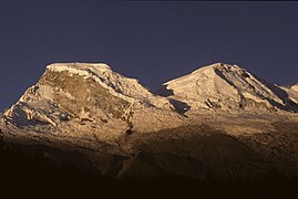
Huascarán (6768 m)

Huandoy (6395 m)

Chopicalqui (6345 m)
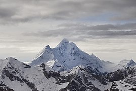
Huantsán (6369 m)


Sports
Football
Sports from Ancash are marked, like the rest of Peru, by the predominance of soccer over any other sport. This sport began to be practiced amateurishly on the Ancashina coast in the 1930s, to later spread to the mountains where the first soccer teams were founded, representing the main neighborhoods of the most developed cities: Chimbote, Huaraz, and Yungay.. Already in 1971, when Ancashino soccer was consolidating, the Peruvian Soccer Federation created the Peru Cup; Being the José Gálvez de Chimbote club, the first Ancashino team to ascend to the first division of Peru, this and Sport Áncash have participated in eleven and five seasons respectively, however, no Ancashino team has achieved the national title to date.
Mountaineering
Due to the existence of a large number of snow-capped mountains both in the Cordillera Blanca and in the Huayhuash, after 1970 with greater dynamism, mountain climbing has been activated as a walk or high-altitude trekking. Private or non-profit organizations participate in the promotion help, guide for peak climbers. Also in Huaraz there is the headquarters of the Casa de Guías and other guide associations. There is a PNP mountain rescue body.
Mountaineering Associations
- Association of Mountain Guides of Peru (AGMP)
- Club Cordillera Blanca
- High mountain guides Don Bosco
Development institutions
Some of the development institutions in Ancash are CEDEP, CARE Peru, Urpichallay that work on issues of decentralization, productive technical support, education, health, and citizen participation.
Ancash cuisine
In addition to its diversity of products, meats and great creativity in the preparation of its meals; the region presents a great variety of dishes. Among them are, to name a few, the spicy guinea pig in the Huaracino style, the early morning dish with head broth, the puchero, the matahambre, the Ancashina patasca in a clay pot, the leg of smoked ham or serrano ham, the chocho ceviche, the classic pachamanca typical of the mountainous regions, tamales, humitas, desserts and drinks typical of the place.
Cuchi Canca (grilled pork), has various ingredients such as vinegar, garlic, mirasol pepper, pepper, cumin and others to taste. Served with golden potatoes or white rice.
Head broth. It is a typical dish of the Ancashina region. It is a broth of travelers and morning people, which is taken in the early hours of the day. To prepare it, boil the lamb's head, mondongo, and garlic; aside a bowl of red onion, coriander, mint, and ground green rocoto; It can also be used as an escort or reinforcement, nickname for corn or peeled wheat, lemon, or other ingredients.
Patasca It is one of the dishes of the altiplano, it is also known as mote soup. It has various ingredients such as peeled corn, mutton or cow meat, mote (boiled corn), mint, chili pepper, onion and other ingredients. In Ancash they do not use mondongo in their preparation, instead they use pieces of pork, chicken and fried pork skin, prepared in a clay pot.
Spicy guinea pig. It is a classic dish from the Peruvian highlands; however, each region has a peculiar dressing and presentation. In Ancash, it stands out in the province of Huari, since it is one of the traditional dishes of the place. The Ancashino dish is based on roasted peanuts and panca peppers, meat broth and yellow peppers. Different formats: jack pichu, red jack, cashqui jack, guinea pig with field.
Smoked ham or Andean ham is typical of the Ancash region. The preparation is somewhat complex, it is a pork leg marinated with salt, then it is pressed, seasoned and dried. After one day, it is smeared with ground chili pepper and smoked for three days. It is served with potatoes and onion sauce; In addition, mote or corn is added to taste. Some restaurants add sachatomate or aguaymanto.
Huallpa cashqui. It is chicken soup, the same one that is prepared with potatoes and large pieces of chicken, noodles, poached egg, and lately even kion; It has a dressing of ground mirasol pepper, and other ingredients, Chinese onion.
Wood ceviche. This dish is a stew that is prepared in part of the mountains. It is seasoned with a Peruvian legume, called tarwi (Lupinus mutabilis), which has great nutritional power (it contains Omega 3). It has almost the same ingredients as a Peruvian ceviche, only that instead of fish it has tawri (Andean ultramuz) and instead of red onion it has Chinese onion.
Lunca cashqui. It is a typical Huaraz soup. It is made from wheat, free-range chicken, chopped Chinese onion, panca chili pepper, celery, carrot, parsley, toasted oregano, Yungay potato, olive oil and other ingredients. It is prepared, preferably, in a clay pot. It used to be served at burials to thank the people who came to say goodbye to the deceased, considered by some Huaracinos as a ritual dish in many aspects. At present they have reinvented it in some restaurants in the region.
Cashqui jackfruit. The guinea pig broth or Aca Cashqui is a typical dish of almost the entire department of Áncash. In the attentions to the butler collaborators, they are bridled with this rich stew. It is served to celebrate the Virgen de las Mercedes and other patronal dedications. In the season of reliogioasa festivities.. It is also served in very cold times, it serves to reconstitute energy, due to its high nutritional power. and regenerative.
The broth is prepared with machom guinea pig (cututo), yellow potatoes, onion, pumpkin, leek, carrot, turnip, muña, ground garlic and capshi noodles or wheat. The guinea pig must have been fed alfalfa or leaf vegetables. It is also consumed in other surrounding regions such as Junín, Huánuco.
Chicha in broth. It is a dish typical of the Ancashina region, be it in the Conchucos district and its special way of preparation or the dish from the Huallanca district. It is also the flagship dish of the province of Pomabamba where chicha is prepared in broth. It is a dish based on free range chicken, chicha de jora, chancaca, Chinese onion, toasted peanuts, oregano, mirasol chili, panca chili, olives, sugar and spices. However, in the district of Chavín de Huantar, this dish was not considered a typically popular dish; on the contrary, the recipe, with clear differences from that of Popabamba, was owned by few families familiar with this variety.
Dances
Typical dances
Each Ancashino town has in its folklore numerous and varied dances; and others that are common to the mountain folklore of the country, but with certain original ingredients such as the huayno, the marinera, the parade, the carnival, etc. The typical dances of the region are:
- Antihuanquillas. Dance executed by 10 or 12 dancers who wear a bush adorned with artificial flowers of colors, polychrome metal masks, a small poncho, a vest of dark fabric and a blue pants. They have a meaning attached to inca wars. Etymologically it comes from the word “anti-envolvement”, it is a dance like Huanquilla but brought by the inhabitants of the Peruvian East.
- Wancas or Wanquillas. Danzan in the break and entrance, in the central day, and in the eighth through streets and squares with move and traditional music. The dancers are those who participate directly in the number of pairs of eight, twelve or more with multicolored dress.
- Shacshas. It is interpreted by an approximate 10 to 20 dancers and a captive in the center, which dresses a cap or outfit with mirages or lentils, a zipper posts with rules, a woman's blouse with spins and blonda, colored pants with her chancellors. This dance represents a satire, in which it is shown as the Negritos celebrate Christmas for a permit granted by the domicile lord.
- Grills. Simulates the struggle of two tribes. The savages intend to kidnap the elve's daughter, encourages them the box and the pinkullo, while the captain is stopped by her parents and the pallas are encouraged by the harp and violin.
- The Atahualpas. Current dance brought by the paramongae. Multi-colored costumes with red skins, with a turkey feather that covers from the head to the back, colored blouses and skirts with fringes.
- The Negritos. Satellite dance, made by 8 or more people. It has an arp accompaniment, violin and trumpets with sordina (instrument to moderate the sound). Its costume composed of a black stub, hat adorned with artificial flowers, wooden mask or leather. Dances and pantomimes and so-called performances.
- The Chuscada Ancashina. It is joyful and danceable, it is combined with the raft, the sailor and the sad. Many dances have expressions of incaic and virreinal life; others represent war and conquest.
- The Pallasespecially those from Corongo.
Contenido relacionado
King's Cross Station
The town of the river
Paterna de rivera