Department of Amazonas (Peru)
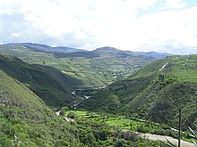
Amazonas is one of the twenty-four departments that, together with the Constitutional Province of Callao, make up the Republic of Peru. Its capital is Chachapoyas and its most populated city is Bagua Grande. It covers 39.2 thousand km² of rugged territory, mostly covered by the thick jungle of the tributaries of the Marañón River, such as the Santiago River and the Utcubamba River. Located in the north of the country, it borders the departments of Cajamarca to the west, La Libertad to the south, San Martín to the southeast, and Loreto to the east, as well as the Republic of Ecuador to the north. In the 2017 census, the department registered a total population of 379,384 inhabitants, with a density of 9.6 inhabitants/km², which makes it the fourth with the lowest population density, only ahead of the departments of Ucayali, Loreto and Madre de Dios..
During the Viceroyalty, it was one of the eight parties that came to have the administration of Trujillo. In 1802 the towns of Lamas, Moyobamba and Tarapoto were transferred from the Chachapoyas party to the recently created General Command of Maynas. Already in 1821 after independence with the Provisional Regulation of the liberator Don José de San Martín, Trujillo became a department and Chachapoyas one of its provinces. On November 21, 1832, the department of Amazonas was created with three provinces: Chachapoyas, Pataz and Maynas, transferred from the department of La Libertad (called Trujillo until 1823). In 1840, the province of Pataz was returned to La Libertad and in 1853 the territories of Maynas were separated to form the Political-Military Government of Loreto with its capital in Moyobamba. Thus, Chachapoyas remained as the only province of the dismembered department of Amazonas until the creation of the province of Luya in 1861. It was followed by the province of Bongará in 1870, the province of Rodríguez de Mendoza in 1932, the province of Bagua in 1941 and more recently the province of Utcubamba and the province of Condorcanqui in 1984.
Toponymy
The current territory of the department corresponded during the Viceroyalty in its majority to the party of Chachapoyas, one of the seven that made up the intendancy of Trujillo. In 1821, after Independence and with the Provisional Regulation of the liberator José de San Martín, Chachapoyas became a province and Trujillo a department, which would change its name to La Libertad in 1823. On November 21, 1832, the department of Amazonas was created transferring the Libertad provinces of Chachapoyas, Pataz and Maynas (in the latter were the Amazon River and its tributaries). On February 10, 1840, the province of Pataz was reintegrated into the department of La Libertad and on March 10, 1853, the Maynas territories were separated to form the Political-Military Government of Loreto with its capital in Moyobamba. It was thus that the name of "department of Amazonas" to the province of Chachapoyas, without taking into account the obvious geographic discrepancy between the name and the region that persists to this day. Amazonas is therefore a residual and geographically incongruous place name, since the Amazon does not flow through the current department.
History
In the lower basin of the Utcubamba river, the first traces of the ancient inhabitants of Amazonas were developed; Yamón, Lonya Grande, Chiñuña, Limones, Tablarrumi, Carachuca, present the oldest cave icons in the region and that belong to the pre-ceramic period. In the 70s, the archaeologist Ruth M. Shady Solís determined that after the first itinerant settlers, the great Bagua culture (1300-200 BC) belonging to the formative period settled, the places she worked are located in the current provinces of Bagua and Utcubamba (Bagua, La Pêca - Morerilla, El Salado); In the past, the Utcubamba plain played a fundamental role, since it was a kind of meeting place between the inhabitants of the low jungle and the people who came from both the coast and the rugged mountain range, with the purpose of bartering their products.
On April 17, 1549, the Spanish captain Diego Palomino arrived at the Chuquimayo River (Chinchipe), from there he left to visit different regions of the current provinces of San Ignacio, Jaén, Utcubamba and Bagua. After having inspected the valley of the lower Utcubamba (right and left banks) he made a list of the most important thing that seemed to him and later he sent the document to the King of Spain.
In La relación de Diego Palomino y en la relación anómina de la tierra de Jaén, some aspects of the social, political, and economic life of the inhabitants of lower Utcubamba in the 16th century are reported.
- Houses used when it rained: constituted by a set of horcones; on top they placed branches of tree, the same ones that covered with straw, in some cases the fences.
- Houses used when it did not rain: similar to the previous ones, but they diverged, because they were not constituted by straw, these beds used them when the heat was incessant because they were very angry.
- Indumentary: in 1549, it was established that the current Utcubamba river would be called Bagua. On its left side was the village of the same name today called Bagua Grande, capital of the province of Utcubamba.
- Men: the garment is made with cotton; the preferred garments were the t-shirts, the bracelets and a coloured blankets; in the backs of the arms they used bone or shell.
- Women: they were covered with a small blanket, which bore it under the navel until half a thigh; they brought a narrow strip like a chumbe, to cover their breasts; they tied themselves in the corves, above the calves, many rounds of account of a chaquira; the hooligans carried them so tight, that when they were pulled out, there was a sign of four.
- Static hair: they brought the hairs, the hairs braided from behind in two parts (as women are braided), plus two small strokes on each side of the face.
- Food diet: they consumed the following products: corn, achira, camote, yuca, streaks, peanuts, pumpkins; with respect to the fruits we have: zapotes, guabas, guayabas, lucumas, tunas, caimitos, jaguas, paltas; to the entire previous supply the consumption was supplemented with honey of bee and fishing in the cracks and in the river.
- They were great swimmers: Palomino was very impressed, by the way as wonderful as the natural ones moved to the surface of the Utcubamba river; they knew how to swim from the beginning to walk both men and women; the women used to drive some small child through the river and if they detected danger on the ground they plunged with the child, to get a good stretch out; they passed the food from one shore to another, swimming,
- Disappearance: 1580 ago, the relation of the land of Jaen notifies that the inhabitants of the lower Utcubamba were completely subject to the encomiendas; the obligatory taxation, the imposition of jobs in the gold sinks and the epidemics (pox, measles and the evil of the bubas, etc.), gradually ended up decimating them, until their total disappearance in the eighteenth century.
Other historical data
In the southern part of the department of Amazonas, the prominent Chachapoyas or Sachapuyos culture developed. Its tombs and cities, its platforms and ceramics, its temples and fortresses testify to the progress achieved by this civilization. The Kuélap fortress represents his maximum legacy. On the other hand, the Chipuric and Revach cultures (800 to 1200 AD) developed in the province of Luya.
Around 1475 the region was annexed to the Inca Empire; Later, the Spanish invaded the territory and founded on September 5, 1538 The very noble and loyal city of San Juan de la Frontera de los Chachapoyas today known simply as Ciudad de Chachapoyas. From then on it became the capital of eastern Peru, since Chachapoyas gravitated as the center of operations for the conquest of the jungle. In the end, the settlers supported the independence and in April 1821 they supported the action of the army of José de San Martín y Matorras, ignoring the Spanish authority. Having as a consequence the great battle of Higos Hurcos on June 6, 1821 where the Amazonian patriotic forces under the command of Matea Rimachi achieved the victory for freedom against Spanish rule.
Recent history
In 1995, the border area with Ecuador was the scene of the Cenepa war.
In 2009, a social conflict caused by the promulgation of two legislative decrees that affected indigenous communities caused a confrontation between the police and natives known as Baguazo, leaving 33 people dead.
Geography
The department has an area of 4,205,038 hectares and is home to ecosystems such as the low jungle, high jungle or yungas, Andean ecosystems, and tropical dry forest. The region is divided into 7 provinces and 84 districts.
Hydrography
- Rios: Marañón, Chinchipe, Utcubamba, Chiriaco or Imaza, Silaco, Nieva, Jumete or Vilaya, Cenepa and Santiago.
- Lagunas: Laguna de los Condores (Chachapoyas-Leymebamba), Laguna del Porvenir (Bagua - Aramango), Laguna de Chonza (Bagua - Copallín), Pomacochas (Bongará) more than 2000 msnm.
Relief
Its relief is very rugged, it covers inter-Andean and jungle regions. In it, the Cordillera del Cóndor stands out, between the Peru-Ecuador border, the Andean Central Cordillera, which gives rise to the Marañón River hydrographic basin. In the northern part it moves to the east, on flat terrain, and small topographical accidents. To the south, its relief is rugged and with greater heights.
It has the following geographical features:
- Abras:
- Black Barre (3 680 msnm) in Leimebamba District, province of Chachapoyas. Part of the route PE-08B
- Mines (3 506 msnm) in the province of Luya
- Yumal (3 345 msnm) in the province of Luya
- Miguel Pardo (2 930 msnm) in Bongará and Rioja;
- Chanchilla (2 212 msnm) in Chachapoyas province;
- Campanquiz (1 200 msnm) in Condorcanqui province
- Pongos:
- Dorpin (600 msnm)
- Manseriche (500 msnm)
- Rentema (500 msnm) in Bagua;
- Huaracayo (450 msnm)
- Umari (450 msnm) in Condorcanqui
- Cumbinama or Sasa (450 msnm)
- Escurrebraga (400 msnm).
Location
It is located in the northeast of the country, it has part of the mountains and jungle. It limits to the north with the Provinces of Morona Santiago and Zamora Chinchipe in Ecuador; to the east with Loreto; to the southeast with San Martín; to the south with La Libertad; and to the west with Cajamarca. Its Andean relief is formed by the so-called Cordillera del Cóndor (east of the Andes mountain range).
Its area of 39,249 km² is similar to that of Switzerland. Its coordinates are 2° 59' south latitude and is located between the meridians 77º 9' and 78° 42' west longitude.
Climate
Varies from 40 °C in the north to 2 °C in the southern ranges. The average temperature is 25 °C. In the Amazon jungle the temperature is high.
Flora and fauna
The department is the habitat of endemic birds such as the Marvelous Spatuletail (Loddigesia mirabilis, Marvelous spatuletail) or Whiskered Owl (Xenoglaux loweryi, Long-whikered owlet).
- Fauna
- Mammals: tingling bear, puma, bandana, huangana, sajino, canchul, cashapicuro, carachupa, chosca, ronsoco, majaz, monkeys, rodents.
- Fish: zungaro, gamitana, bochico, maiden, silver, cashca, trout, tents, bagres.
- Ofidios: Macanche, Colambo, Uyure, Cascabel, Shushupi, Otorongomacha, Curumamán.
- Flora
- Wooden trees: mahogany, cedar, chonta, poma, blood tree, cross stick, cocobolo, quinilla, asarquiro, quilloscapi, quillocisa, chilca brava, yngaina.
- Medicinal plants: copaibo, sachindaso, hoje, agria rod, quinaquinaquina, zarzaparrilla, alolva, piñón, ancusacha, bagmullaca, chinchirilla, atapi, cow's eye.
In the Mesozoic era, the lower Utcubamba territories were the habitat of the Titanosaurus sauropod and the fearsome theropod Carnotaurus sastrei. The fossil bones were collected both in the pongo de Rentema (Bagua) and Quebrada Seca (Utcubamba); Currently these fossils and full-scale models are on display at the "Javier Prado" from Lima.
The megafauna is represented by the Baguatherium that lived 31 million years ago in the lower Utcubamba (Huarangopampa town, El Milagro district). It had characteristics similar to rhinos and sachavacas; It measured almost three meters in length and weighed approximately 2.5 t. Studies indicate that this mammal probably fed on plants that grew on the banks of a sea located in what is now the Amazon. The investigations reached these conclusions after analyzing a maxilla, isolated teeth and a femur of this animal found in the area.
Administrative division
The Amazon Region is divided into 7 provinces:
| Provinces of Amazonas | |||||||
|---|---|---|---|---|---|---|---|
| Ubigeo | Province | Surface (km2) | Population 2015 | Density (/km2) | Capital | Altitude msnm | Districts |
| 0101 | Chachapoyas | 3 312,37 | 55 201 | 15,00 | Chachapoyas | 2 339 | 21 |
| 0102 | Bagua | 5 652.72 | 76 921 | 12,69 | Bagua | 421 | 6 |
| 0103 | Bongará | 2 869.65 | 33 920 | 9.57 | Jumbilla | 1 991 | 12 |
| 0104 | Condorcanqui | 17 975.39 | 54 949 | 2.41 | Santa Maria de Nieva | 222 | 3 |
| 0105 | Luya | 3 236,68 | 51 849 | 14,93 | Lamud | 2 307 | 23 |
| 0106 | Rodríguez de Mendoza | 2 359,39 | 31 192 | 11,18 | Mendoza | 1 584 | 12 |
| 0107 | Utcubamba | 3 842.93 | 118 597 | 28,37 | Bagua Grande | 446 | 7 |
Districts
The Amazonas Region is divided into 84 Districts
Authorities
Regionals
The Amazonas Region has its own regional government in addition to constituting an electoral district that elects five congressmen.
- 2019 - 2022
- Regional Governor: Oscar Altamirano Quispe, of the regional Amazonian Force movement.
- Regional Deputy Governor: Milecio Vallejos Bravo, of the regional Amazonian Force movement.
- Counsellors:
- Chachapoyas: Mario Yldefonso Torrejón Arellanos (Independent Movement Surge Amazonas)
- Bagua:
- Liliana Zurita Mejía (Amazon Force Regional Movement)
- Teodoro Luis Delgado Cubas (Regional Amazon Feeling)
- Bongará: Jorge Luis Yomona Hidalgo (Regional Amazonian Force Movement)
- Condorcanqui:
- Dinenson Petsa Ijisan (Regional Amazon Feeling)
- Leandro Calvo Nantip (Regional Political Movement Amazon Community Energy)
- Luya: Second Macario Bravo Zorrilla (Independent Movement Surge Amazonas)
- Rodríguez de Mendoza: Perpetuo Santillán Tuesta (Amazon Force Regional Movement)
- Utcubamba: Merly Enith Mego Torres (Amazon Regional Movement to the Field)
Police
Colonel PNP Ángel Luis Granados Ríos
Religious
Of the Catholic religion:
- Mons. Emiliano Antonio Cisneros Martínez, OAR (Obispo de Chachapoyas).
Demographics
Its population amounts to 417,508 inhabitants (an approximate demographic density of 10 inhabitants/km²), of which 203,158 are men and 195,424 women.
Transportation
The predominant transportation is by land routes, such as paved roads, affirmed roads or trails for cars. Listed below are some routes that can be taken from the capital of the country:
- Route 1: By the North American road from Lima to Chiclayo; from there to Olmos-Jaén-Bagua Grande-Pedro Ruiz Gallo-Chachapoyas.
- Route 2: From the North Pan American road to Pacasmayo. Then, Tembladera-San Pablo-Cajamarca-Celendín-Balsas. From Balsas, there are two routes: one to Chachapoyas and Bagua and one to Mendoza.
- Route 3: The Central road from Lima to La Oroya. From there, follow Junín-Cerro de Pasco-Huánuco-Tingo María-Tocache-Juanjuí-Bellavista-Tarapoto-Moyobamba-Rioja-Pedro Ruiz Gallo.
Among the river ports, Rentema (Bagua province), Nazareth (Bagua), Choros (Utcubamba province) and Galilea (Condorcanqui province) stand out.
Culture
The folklore of the department of Amazonas can be seen here in the profusion of dances, songs, and clothing found in other departments, for example, Puno or Cuzco. Its folklore is nourished rather by legends, stories and tales in which mystery and the inexplicable are always present. Towns, lagoons, hills, images, always have an origin that invariably contravenes the rules of logic or biology.
Dances
Some of the most representative dances of the Amazonas Region are:
- The Chumaichada
- Huanca (baile)
- The Levant Dancers
- Carnival Chachapoyas
- The Brazo
Festivities
- Patron Festival of Santiago Apostle province of Utcubamba (July 23-31)
- Carnivals In Amazonas in the province of Chachapoyas (24 March)
- Tourist Week of Los Chachapoyas in the province of Chachapoyas (1 June)
- Fiesta Patronal Virgen Asunta, province of Chachapoyas in the Chachapoyas district (1 August)
- Patronal Feast of the Lord of Gualamite, province of Luya in the Lamúd district (1 September)
- Fiesta Patronal de San Nicolás, province of Rodríguez De Mendoza in the San Nicolás district (7 September)
- Fiesta Patronal de Virgen de Sonche
- Fiesta Patronal de Virgen de Levanto
- The Christmas Shepherds
Economy
Amazon is a region of enormous agricultural potential. Its economy depends on agriculture and livestock. In Bagua, agriculture is highly developed in the case of rice crops. Its production of potatoes, corn, coffee and sugar cane and the consumption of fish is notorious.
Tourist attractions
Archaeological
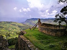
- Kuélap: (Kuelap-Luya) Archaeological remains well preserved above the Utcubamba River Valley, the most interesting place in the department of Amazonas. For more information, look at Kuélap. Located 3 072 msnm, in the southwest of Chachapoyas, on the bottom of a broken cut to peak by two sides. It is estimated that it has three times the volume of the pyramid of Keops (Egypt), which was abandoned before the conquest and which was inhabited by about 2 000 people.
- Sarcophages of Carajía belonging to the Chachapoyas culture, are sarcophages of 2.5 m high on the Laguna de los Condores.
- Mausoleos de Revash (Saint Thomas (Luya)), belonging to the Chachapoyas culture, are caves used for graves. 20 min from Iron Good.
- Leymebamba Museum (Leymebamba-Chachapoyas): The museum, opened in 2000, houses 219 mummies found in the Laguna de los Condores.
- Archaeological site of Llactán or Anguyo Alto (La Peca-Bagua): It is located two hours from the town centre of Arrayán. It is a series of buildings on the skirt of the central mountain range of the Andes, the structures are semi-circular and possibly served as a place of vigilance, since from there you can see the entire valley of the bass Utcubamba, Marañón and Chinchipe.
- Kakachaken Archaeological Centre: Located in the district of Quinjalca, on the banks of the river Imaza, adjacent to the district of Olleros, is located in a beautiful cliff between trees and rocks, there was found a number of human remains of the ancient Quinjalcas.
Natural
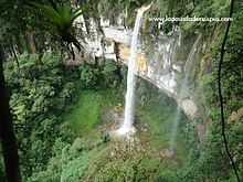
- Yumbilla Fall (Cuispes district, Bongara province): With 895.4 meters high, it is the highest cataract in the region and one of the highest in the world. It is 25 minutes from Pedro Ruiz Gallo and just over 1 hour from the city of Chachapoyas. On the same mountain and accompanying the imposing Yumbilla cataract, there are two other huge cataracts: 560 meters high Chinata and 400 meters high Pavilion, all of them in a forest of jungle eyebrow, in which they can be found among others, Cock of rocks, bear of glasses, yellow tail monkey, slots and hummingbird tail of spatula.
- Catarata Gocta (Valera district, Bongara province): With its 771 meters high, it becomes the fourth highest cataract in the world, it was publicly released in 2006 by German researchers.
- Chigliga Fall (Distrito de Shipasbamba, province of Bongara): 7 cataracts of an average height of 75 meters. They are accompanied by great diversity of flora and fauna such as the gallows of the rocks, the hummingbird tail of spatula, the bear of glasses, etc.; as well as wood plants, such as cedar, quina, etc.
- Shipasbamba (Distrito de Shipasbamba, province of Bongara): A 2285 msnm are tourist complexes such as the rumi table lagoon, thermomedical waters, etc.
- Numparket Fall (Aramango district, Bagua province): it has a fall of 90 meters high, its waters will constitute the ruin of Aramango.
- Cavernas de Cambiopitec (Copallin district, Bagua province): There are two caves that in the formative period had human occupation. They are located in the hamlet of Cambiopitec; to get there you have to trajinar two and a half hours on foot or twenty minutes by car from the town of Copallín. Staircases have been built for access. All year is timely for visits.
- Caverna de Churuyacu (La Peca district, province of Bagua): located one hour from the district of La Peca, between greens and seeds of coffee. Its entrance is rugged, its interior with large and narrow passages, a lot of stalactites and stalagmites.
- Pongo de Rentema (La Peca district, province of Bagua): it is the entrance of the Marañón river in the central mountain range. It is only 14 km from the city of Bagua and 400 msnm.
- Pongo de Manseriche (Rio Santiago district, Condorcanqui province): It is a 12 km long parade for 45 meters wide (in its narrowest part), which concentrates the waters to cause a noise that extends over several kilometers to the round.
- El Arenal Canyon (La Peca district, province of Bagua): Natural court of the mountain range made by the La Peca ravine.
- Pomacochas Lagoon (Florida district, Bongara province): its area is 3 km. The depth of 100 m in the deepest part. It's only 2 hours from Bagua, Av. Jungle Marginal in a van. It is favorable for swimming, fishing and boat ride.
- Laguna El Porvenir (Aramango district, Bagua province): its area is 1.5 km. The depth of 80 m in the deepest part. It's only 2 hours from Bagua, in a rural van. It is favorable for swimming and boat ride.
- Utcubamba Valley, it has a stone monument of huge walls finished around the thirteenth century.
- Paradise of Orchids, in the province of Bongará, 40 km from Pomacocha Lagoon, where there are more than 2500 varieties of that flower.
- Native communities (Bagua Y Condorcanqui): The jungle districts of Bagua, Aramango and Imaza are inhabited. They possess their own language and unique craftsmanship. Representatives of this human group are the Aguarunas and the Huambisas.
Historical monuments
The following assets are considered historical monuments of Peru (in brackets, the date of publication in the Official Gazette El Peruano):.
- Church of San Carlos, San Carlos (province of Bongará) (26/04/1989)
- Historic Center of the City of Chachapoyas (province of Chachapoyas) (12/11/1988
- Church of Santa Ana de Chachapoyas (province of Chachapoyas) (04/04/1990)
- Casa de don Toribio Rodríguez de Mendoza, Chachapoyas (provincia de Chachapoyas) (30/12/1986)
- Pampa de Higos Urco, Chachapoyas (30/12/1986)
- Plaza Mayor and surrounding buildings of La Jalca (province of Chachapoyas) (12/11/1988)
- Church and court of La Jalca (province of Chachapoyas) (12/11/1988)
- Levanto Arms Square (Chachapoyas Province) (12/11/1988)
- Church and chapel Poza de Levanto (province of Chachapoyas) (12/11/1988)
- Levanto Cacique House (Chachapoyas Province) (12/11/1988)
Education
The Amazonas Region has a total of 1,530 public and private schools: 285 for initial education, 1,082 for primary education, and 425 for secondary education.
The department is the headquarters of the Toribio Rodríguez de Mendoza de Amazonas National University.
Contenido relacionado
Queretaro
Seville Province
May 20th


