
Danube
The Danube is one of the most important rivers in Europe that runs through the central-eastern part, in a mainly west to east direction, passing through, or bordering, ten countries —Germany, Austria, Slovakia, Hungary, Croatia, Serbia, Romania, Bulgaria, Moldova, and Ukraine—and flowing into the Black Sea, where it forms the Danube Delta, a region of great ecological value. It has a basin of more than 817,000 km²—representing 8% of the European territory where 10% of its population lives—and which also drains parts of Switzerland, Italy, the Czech Republic, Poland, Ukraine, Slovenia, North Macedonia, Bosnia and Herzegovina, Montenegro, Albania and Kosovo. With 2850 km it is the 2nd longest river in Europe —after the Volga—, the 26th primary and the 31st overall in the world. Its river network consists of about 120 major tributaries: the longest, the Tisza (1378 km), the Sava (1170 km) and the Prut (953 km); those with the highest flow, the Sava (1513 m³/s), the Tisza (814 m³/s) and the Eno (or Inn) (753 m³/s); and those with the largest basin, the Tisza (157,100 km²), the Sava (95,720 km²) and the Siret (44 835 km²).
The Danube originates on the German Baar Plateau in the Black Forest (at an altitude of 1078 m), where two small rivers, the Brigach and the Breg, join 1.4 km from the small town of Donaueschingen. The upper course is close to the city of Vienna and runs through Germany and Austria, draining part of Switzerland and Italy. Here the Danube is a typical mountain river, flowing through the Black Forest, the Swabian-Bavarian plateau and the narrow section between the Alps and the Czech massif. Its valley is narrow and deep, with high and steep slopes. The channel width varies from 10−100 m, in the Ulm city area, to 100−350 m in the Vienna area. The speed of the current is 1.0−2.8 m/s. In some places the riverbed has been conditioned with protection dikes. In this section, the largest tributaries it receives are mainly from the right (Eno, Isar, Lech, Ens), originating in the Alps.
The middle course covers the section from Vienna to the Iron Gates Gorge, where it crosses the Middle Danube Plain and passes through Austria, Slovakia, Hungary, Croatia, Serbia and Romania. Between Vienna and the Hungarian city of Vác it flows in an easterly direction; then to the Croatian city of Vukovar, heading south; and, from the Iron Gates, in an east-southeast direction. In the Middle Danube plain the valley is 5−20 km wide, with two distinct floodplain terraces: the channel meanders and divides into arms apart and the speed of the current slows down to 0.3−1.1 m/s. In some places, the river overcomes separate low hills and crosses transverse hills, forming gorges (Hungarian Gate, Visegrad gorge, Iron Gates, Kazan gorge). In these sections its valley narrows to 0.6−1.5 km, and to 150 m, as its depth increases significantly (up to 15−20 m, in the Kazan Gorge, with 70 m wide), and its velocity increases to 2.2−4.7 m/s. As a result of the hydroelectric infrastructures built, most of its meanders have disappeared, some of the small lateral sleeves have dried up and dikes have been built to protect against water. In this section the Danube receives its largest tributaries (Sava, Tisza, Drava, Velika Morava, Vah), and its drainage area is greatly expanded, with parts of Italy, the Czech Republic, Poland, Ukraine, Slovenia, Bosnia and Herzegovina, Albania and Kosovo.
The lower course runs from the Iron Gates gorge to the estuary, a section passing through Serbia, Bulgaria, Romania, Moldova, and the Ukraine; It flows initially southeast (to Vidin), then east (to Silistra), and finally north (to Galati) and east again to the mouth. Here the Danube is a typical lowland river, flowing through the Lower Danube lowlands. Its valley widens to 7−20 km, and the width of its floodplain terraces also divides it into numerous branches and straits. The channel in some places reaches 1−2 km, with an average depth of 5−7 m and a velocity of 0.5−1.0 m/s. In this section the most important tributaries are the Prut, Siret, Olt, Ialomița, Iskar and Arges rivers. At its confluence with the Black Sea, the Danube forms a large delta (area 3500 km²), which is divided into 3 main branches (gorges): Kiliyski, Sulinski and Georgievski. The northernmost, the Kili branch, serves as the border between Romania and Ukraine; the middle arm, the Sulinsky, is the deepest and the main navigable route.
Dozens of large cities lie on the banks of the Danube, including the capitals of four countries — Austrian Vienna (1,911,191 inhabitants), Serbian Belgrade (1,378,682 pop.), Hungary's Budapest (1,752,286 pop.) and Slovakia Bratislava (437,725 inhab.)—, the capitals of various subnational entities —Linz (state of Upper Austria 206,595 inhab.), Győr (Győr-Moson-Sopron County), Vukovar (Vukovar-Srijem County), Vidin (Vidin Province), Drobeta Turnu Severin (Mehedinți District), Calarasi (Calarasi district), Giurgiu (Giurgiu district), Tulcea (Tulcea district— and several cities with a great historical tradition such as Ulm, Regensburg, Passau or Esztergom. The historic centers of Budapest (1987), Vienna (2001) and Regenzburg (2006), have been declared World Heritage Sites. of Humanity, as well as the Srébarna Nature Reserve (1983), the Danube Delta (1991) and the section of the Wachau Cultural Landscape (2000).
In the course of the Danube many sections have been protected, highlighting in Germany, the Upper Danube natural park, "Donau Auen between Neuburg and Ingolstadt" and the Donauleiten protected area; in Austria, the Danube-Auen National Park; in Slovakia, the Danube floodplain protected area; in Hungary, the Danube-Ipoly and Gementz National Park; in Croatia, the Kopački Rit Nature Park; in Serbia, the Upper Danube Nature Reserve, the Fruška Gora National Park, the Kovilsko-Petrovaradinski Rit Nature Reserve, the Great Military Island Nature Reserve and the Đerdap National Park; in Romania, the Iron Gates Nature Park, the Machina Nature Park, the Little Braille Lake Nature Park and the Danube Delta Biosphere Reserve; and in Bulgaria, the “Park” nature park, the Kalimok-Brushlen protected area and the Srébarna nature reserve.
The Danube was included in the list of several of the most threatened rivers in the world, prepared for World Water Day in 2007.
During the Ancient Ages, it constituted one of the natural borders that formed the limes of the Roman Empire (together with the Rhine and other rivers and some fortified stretches). In classical sources it was called Istro. Charlemagne's route, which was used between 1096 and 1099 by Godefroy de Bouillon's army during the First Crusade, followed the Danube, which he also followed, in the opposite direction and 340 years later., the Ottoman army that wanted to take Europe, a route that they will follow in many more campaigns until arriving in 1529 to surround Vienna itself.
Etymology
The German toponym for the Danube is Donau (![]() pronunciation (?·i)) in Slovak Dunajin Hungarian Dunain Croatian, Serbian and Bulgarian is called Dunav (in Cyrillic .) in Romanian Dunăreain Russian and Ukrainian . (Dunaj), in English (as in French) Danube and Turkish Tuna. All these names come from Latin Danubius that would be the name of a deity of the rivers. This indoeuropean etym is found in the Sanskrit dānuwhich means “god” or “current”. Other names of European rivers that may come from this same indo-European root are the Donets, the Dnieper, the Dniester, the Don in Russia, the Don in the United Kingdom and the Dão in Portugal.
pronunciation (?·i)) in Slovak Dunajin Hungarian Dunain Croatian, Serbian and Bulgarian is called Dunav (in Cyrillic .) in Romanian Dunăreain Russian and Ukrainian . (Dunaj), in English (as in French) Danube and Turkish Tuna. All these names come from Latin Danubius that would be the name of a deity of the rivers. This indoeuropean etym is found in the Sanskrit dānuwhich means “god” or “current”. Other names of European rivers that may come from this same indo-European root are the Donets, the Dnieper, the Dniester, the Don in Russia, the Don in the United Kingdom and the Dão in Portugal.
In German, the ending au comes from the Germanic hydronym *awa and the place name “Donau” has been used since 1763. In older German documents, there are also the appellations «Tonach» and later «Donaw ».
The other names are in Latin Danubius or Danuvius and in ancient Greek στρος (Istrians).
Mythology
Under the name of Istros (in ancient Greek, Ἴστρος, romanized: Istros) the Danube is one of the 25 children of Thetis and Oceanus, cited by Hesiod in his Theogony, where he recounts the creation of the world:
And Tetis, with the Ocean, gave birth to the voraginous Rivers: the Nile, the Alpheus, the Eridan of deep tugs; the Strimon, the Meandro, the Istro, of beautiful currents; the Fasis, the Reso, and the Elooo, of silver tomolines; the Neso, the Rodio, the Hanoranium, the Beautiful Manicure,Hesiod, Theogony
The myth of the Argonauts relates that, to return to Argos, they went up the Istros (Ister) from the Euxinus Pontus (Black Sea) to its source and then returned to the Adriatic Sea through another branch of the river. Diodorus of Sicily (1st century BC) already pointed out the impossibility of such a thing and attributed that legend to the homonymy between the Istros (Danube) and the region known as Istria north of the Adriatic Sea. It is the Danube that flows into the Inn in Passau (Germany); the ancients would have ascended not by the Danube but by the Inn (with greater flow) until its source (near Sankt Moritz), where there is an important watershed (towards the Rhine and the North Sea, towards the Danube and the Black Sea, and towards the Po and the Adriatic Sea).
The southern mouth of the Danube was occupied by the Milesian Greek city of Istros or Histria founded around the 7th century BCE. C.. The river marked the border between the Greek world and the Scythian world.
History
The Danube basin is a very wide region, whose peculiarity began from very remote times in Prehistory. The name Danube contains the Indo-European hydronym *danu- 'running water, river' very common in eastern Europe (Dnieper, Dniester, Don, etc.).
Prehistory

Some of the oldest European civilizations have settled in the Danube basin. Among the Danubian Neolithic civilizations, there are in particular the civilizations of the bands of the center of the Danube basin. In the Chalcolithic, the Vučedol culture (named after the Vučedol site near Vukovar in Croatia), notable for its ceramics, settled around the river. Numerous Vinča culture sites, dating from the 6th to 3rd millennium BC. C. are found along the Danube.
Antiquity


In the seventh century B.C. C. the ancient Greeks ascended the river from the Black Sea passing through the city of Tomis, now Constanța. Their upriver voyage of discovery ended near Drobeta, the point from which the whirlwinds of the "Iron Gates," a narrow and steep gorge, made it impossible for navigators of the time to progress towards the Carpathians. South and the Serbian Ore Mountains.
For the ancient Romans, from 37 AD. C., the Danube was the border between his Imperium and the Barbaricum of the North, between the civilized and urbanized world governed by law, and a freer world governed by law. habit. Virtually from its source to its mouth, a permanent Roman fleet, the classis, was maintained there. As long as the river didn't freeze over, that fleet was enough to stop the Teutons, Dacians, and Scythians from crossing it, since they had no technology to counter it. When the river froze, it was the legions stationed on the right bank of the river that took over. Marcus Aurelius achieved several victories over the Marcomanni thanks to the classis. The Romans dominated the river until Valentinian I (364-375) except for a few very cold years (256-259, when the bases and many of the boats were taken by surprise).
The Roman Empire did not cross the Danube into Dacia until after they had built Trajan's Bridge, the work of Apollodorus in AD 101. C. at the height of the garrison city of Drobeta located near the "Iron Gates" and after having fought two battles in 102 and 106. This victory of the emperor Trajan over the Dacians under the orders of Decebalus allowed the creation of the province of Dacia which was abandoned in 271. Those two battles constitute the frieze of Trajan's column, in the center of his forum, in Rome. The bridge was for over a thousand years the longest ever built. On both banks of the Lower Danube, the Romanization of the Thracians led to the Thracian-Romans, speakers of Eastern Romance languages, later called "Wlachs" by waves of invaders from the east (Huns, Visigoths, Ostrogoths, Vandals, Gepids, Lombards, Avars and Slavs), which from the 3rd to the 5th century passed through the Danube basin from east to west and from north to south.
During these great invasions, on the old Roman border, in the midst of these new populations, small Romance communities: the Walcheren, Welschenlants, Walchengaue i> or Valachies (which historians call popular Roma), remain in the forest massifs ((Ardennes, Vosges: Walloons and Welsh) or mountainous (Alps: Romanches, Ladins; Carpathians and Balkans: Wallachians). Bulgars, only to return there for two centuries, from 971 to 1180.
Middle Ages
In the IX century, the middle Danube basin was the settlement area of the Magyar tribes who came from the Urals, who populated what is now Hungary to found there, with the Germanic, Slavic and Vlach populations already transhuming there, the Hungarian nation under King Stephen I of Hungary.
The route of Charlemagne, which was used between 1096 and 1099 by Godefroy de Bouillon's army during the First Crusade, also ran along the Danube from Regensburg to Belgrade. Approximately 340 years later, the Ottoman army took the same route in the opposite direction. The Danube was for them the main artery for the transport of troops and supplies during their campaign through southeastern Europe. The watercourse allowed the Ottomans to advance quickly and from 1440 they fought the first battles for Belgrade, located 2000 km from the mouth of the river. The conquest of the city was unsuccessful, however, until 1521, and only a few years later, in 1526, the Ottoman army defeated the kingdom of Hungary in the first battle of Mohács. When King Ludwig II of Hungary was killed during the battle, Hungary was integrated into Habsburg Austria. This event marked the birth of the "Danube Monarchy".
Modern times and contemporary times
In 1529, the Turks reached Vienna, the heart of central Europe, but were defeated there. Thus the expansion of the Ottomans along the Danube was halted and since the Battle of Mohács in 1687, they gradually lost ground and power. The gradual repression of the Turks rested fundamentally on the initiative of Austria and then of Austria-Hungary, which gained power there and, at the same time, was rejected by the Holy Roman Empire and then by the Germanic zone. Together with Austria However, the Ottoman Empire remained one of the most important political factors in Southeast Europe until the final loss of its Balkan territories during the Russo-Turkish Wars (1768-1774) and the Balkan Wars in 1912-1913.. The Danube then played not only the role of a military and commercial artery, but also a political, cultural and religious link between East and West.
The river's role during the War of the Fifth Coalition in 1809, which saw Austria oppose Emperor Napoleon I, should also be underscored. After their defeats in April, the Austrian army fell back behind the Danube and forced Napoleon to meet him on the other side, if he wanted to make peace with Austria, which would end in the battles of Essling and Wagram
During World War II, the Danube was a major transport axis for Romanian oil, then the main source of German supply, to Reich factories. During the summer of 1944, the Royal Air Force dropped more of 1,500 mines there, between Giurgiu and Bratislava. In a few months, these mines would sink more than 250 ships, including 29 oil tankers, and damage another 200 more, that is, an exceptional proportion of a ship hit by 3 or 4 mines dropped.. This mining will almost completely interrupt traffic on the river
After the Second World War, in 1946 a new regulation of fluvial traffic was elaborated that was to replace the Paris agreements of 1921. All the riparian countries participated in the Belgrade conference of 1948 except the defeated countries, Germany and Austria. When the treaty was signed, an addendum was also signed and accepted by Austria in the Danube Commission. The Federal Republic of Germany was not able to join the commission until 1998, almost fifty years after the Belgrade conference, due to rejection by the Soviets. Currently, only the Danubian countries enjoy freedom of trade and navigation on the river.
Hydrography

The Danube is one of the only major European rivers (along with the Po) that flows from west to east. It reaches, after a course of 2852 km (abbreviated length, which does not take into account the route of the Breg, in the initial course of the Danube, and the main route in its delta), the Black Sea in the Danube delta region (4300 km²), in Romania and in Ukraine. Unlike other rivers, the kilometers of the Danube are counted from the mouth to the source, the "official zero point" being materialized by the lighthouse in the Romanian city of Sulina on the edge of the Black Sea.
The Danube basin drains an area of 802,266 km², corresponding to the following twenty countries: Romania (29.9%), Hungary (11 7%), Serbia (10.3%), Austria (10.2%), Germany (7.5%), Slovakia (5.8%), Bulgaria (5.2%), Bosnia and Herzegovina (4, 8%), Croatia (4.5%), Ukraine (3.8%), Czech Republic (2.6%), Slovenia (2.2%), Switzerland (0.32%), Republic of Moldova (0 29%), Italy (0.15%), Poland (0.09%). Four countries drain very small areas: Ukraine, through the Tisza River, Kosovo, through the sources of the Greater Morava, Albania, through the sources of the Drina and Moldavia river, directly, a very small testimonial surface.
Departing mainly from the Alps, the most important tributaries of the upper course of the Danube come from the right bank, and in the lower course they do, on the contrary, from the left, arriving from the Carpathians, although some do as well of the Balkan mountains. A common etymology has given the same name to two of them: the Morava. From the source to the mouth, the main tributaries are:
- Iller (Iller)147 km and 70 m3/s)
- Lech (285 km and 200 m3/s)
- Altmühl (Altmühl)220 km and 22 m3/s)
- Naab (165 km and 49 m3/s)
- Regen (165 km)
- Isar (295 km and 174 m3/s)
- Inn (517 km and 735 m3/s)
- Traun (153 km and 150 m3/s)
- Enns (254 km and 195 m3/s)
- Kamp
- Morava (358 km and 110 m3/s)
- Leita (or Leitha) (180 km)
- Rába or Raab (322 km and 63 m3/s)
- Váh (413 km and 161 m3/s)
- Hron (Hron)298 km and 55 m3/s)
- Ipe sense (232 km and 22 m3/s)
- Sió, emissary of Lake Balaton, with 39 m3/s)
- Drava (749 km and 577 m3/s)
- Tisza (1378 km and 794 m3/s)
- Sava (990 km and 1564 m3/s)
- Timiș (359 km and 47 m3/s)
- Great Morava (493 km and 232 m3/s)
- Mlava (Mlava)158 km and 14 m3/s)
- River Timok (203 km and 31 m3/s)
- Jiu (331 km and 86 m3/s)
- Iskar (368 km and 54 m3/s)
- Vit (189 km)
- Olt (709 km and 174 m3/s)
- Vedea224 km)
- Osam (314 km and 1,64 m3/s)
- Yantra285 km and 47 m3/s)
- Rusenski Lom196.9 km and 5.6 m3/s)
- Argeș (350 km and 71 m3/s)
- Ialo (417 km and 45 m3/s)
- Siret (706 km and 240 m3/s)
- Prut (953 km and 110 m3/s)
Hydrology

The flow of the Danube, 6500 m³/s measured at the inflow of the three arms of the delta, for a specific flow or Qsp of 8.1 l⋅s-1⋅km-2, is the result of rainfall runoff over its entire catchment area ranging from 2000 mm to 3000 mm in the alpine part to 600 mm in Moravia, for an average of around 800mm. The different tributaries of the Danube show great heterogeneity in their regime: oceanic rainfall regime in western Bavaria, mountain snow-rain in Austria, plain snow-rain in Hungary, plain snow in Wallachia-Moldavia.
The complex pluvio-nival regime of the Danube explains these diverse influences. Until the city of Ulm, it is influenced by the ocean with a maximum of winter abundance. Then its alpine tributaries—the Lech, the Isar, the Inn, the Enns, the Ybbs—make the Danube 80% alpine. The river is then sensitive to winter retention and snowmelt gives it minimal flow. in Linz in December and maximum in May or June (for an average of 1710 m³/s). The influence of snowfall remains noticeable up to Vienna (flow average of 2237 m³/s), with the June maximum being exacerbated by summer rains specific to central Europe. These rainfalls are responsible for catastrophic flooding, the Danube carrying up to 5 times its usual flow: 8000 m³/s in June 1965 and 1970, 9000 m³/s in July 1899. In Budapest and Bratislava, the winter thaw of the plain maintains the maximum abundance in May-June. The contribution of the waters of the Tisza and the Sava makes the high waters earlier, now in spring (April-May), and the low waters deepen from June to September (this is the case of Giurgiu where the flow reaches 5900 m³/s). From the Iron Gates, the Danube becomes sensitive to the climatic regime announcing that of the Russian steppe and giving very low summer flows.
The harsh winters linked to the continental climate mean that the Danube carries ice almost every year and becomes blocked at some point along the way (the gorges, especially) one out of every two or three years. During melting ice, flooding can occur upstream of the ice dam (the ones in March 1956 were the most severe). The main damage was registered in Hungary, where the plain is regularly invaded by water, which required a development policy with the construction of dikes and the rectification of the course.
| Average monthly rate at the mouth of the Danube (in m3/s. Data calculated in the 15-year period) |
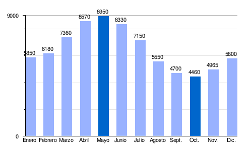 |
The Danube experienced an exceptionally low situation at the end of 2011 (from Germany to the Lower Danube, passing through Austria and Hungary) due to lack of water. The barges could not be loaded to full capacity, the canal narrowed to the point that where 6 barges wide crossed, only one could pass (early December 2011), which also reduced the activity of the river ports.
Geology


Geologically, the Danube is much older than the Rhine, whose basin in southern Germany rivals that of the Danube. This entails some peculiarities.
The Rhine is the only Alpine river that flows north to the North Sea. In doing so, it captures the north-flowing European waters and separates certain parts of southern Germany in two.
Until the last Ice Age, the Rhine began only at the southwestern edge of the Black Forest. Water from the Alps, which today flows into the Rhine, was carried eastward at that time and until the Riss glaciation by the original Danube. The course of this passed further north along a line Wellheim–Dollnstein–Eichstätt–Beilngries–Riedenburg. The gorges of today's Swabian Alb, now devoid of a watercourse, are remnants of the bed of that ancient river which was significantly larger than today's Danube. After a part of the Upper Rhine Plain was formed by erosion, most of the water that flowed from the Alps changed direction to join the Rhine.
Until the present period, part of the waters of the Danube were lost in the porous limestone of the Swabian Jura and joined the Rhine below. As these large amounts of water increasingly erode this limestone, it is assumed that the Upper Danube will one day disappear entirely in favor of the Rhine.
Near Immendingen, the Danube dries up almost completely as its waters seep into the ground and, passing through rivers and underground caves, join the Aachtopf some nine miles away which feeds Lake Constance and, therefore indirectly to the Rhine. This capture phenomenon is known as the Danube sinkhole (Donauversinkung). When the water level is very low, the waters of the Danube seep completely into the ground and it is then only fed by the Krähenbach and Elta streams. As these dry spells have increased considerably in recent years, part of the Danube's water has been diverted from this area through an underground tunnel. The gallery, as well as the artificial waterfall that is part of the work, is found after leaving the village of Immendingen and leads to Möhringen an der Donau.
Until the region downstream of Vienna, the Danube regime is more like a mountain river and only then does it show the characteristics of a large plain river. Factors such as the rapid melting of snow and heavy rains in the alpine environment favor a sudden rise of the river and the occurrence of floods. By regulating the watercourse and removing part of the flood zones, man has amplified this phenomenon: the extent of flooding increased over the century XX. The most intense floods of the last century occurred in 1954, 1988, 2002 and 2013.
Geography

It rises in Donaueschingen, in the Black Forest of Germany, from the union of two small rivers, the Brigach and the Breg, and empties into the Black Sea in Romania. The Danube basin has an area of about 725 985 km² and encompasses many countries in Central and Eastern Europe. The Danube crosses Europe from west to east and crosses (or borders) Germany, Austria, Slovakia, Hungary, Croatia, Serbia, Romania, Bulgaria, Moldova and the Ukraine. It also drains parts of the Czech Republic, Switzerland, Italy, Slovenia, Bosnia and Herzegovina, and Montenegro.
It is navigable, upstream from the Black Sea, by transoceanic ships to Brăila (Romania) and by river boats to the city of Ulm (Germany), at a distance of about 2575km.
About 60 of its 300 tributaries are navigable; the most important are the rivers Lech, Isar, Eno (Inn), Morava, Váh (Vág), Raab (Rába), Drava (Dráva), Tisza, Sava (Száva), Siret and Prut. There are canals linking the Danube with the Main, Rhine, and Oder rivers, and another canal leaves the Danube to flow directly into the Black Sea at the port of Constanta, before reaching the delta.
Its flow is 6500 m³/s (or 204 km³/year), as befits a river with a large basin. Its peak flow at the Puertas de Hierro dam was measured on April 13, 2006 and reached 13,400 m³/s. The Danube has caused disastrous flooding in almost all the countries it flows through, especially Romania. Its flow in Vienna is already on average about 1900 m³/s, in Budapest it is 2350 m³/ s and in Belgrade about 5000 m³/s. In the upper reaches in the Tuttlingen district of Baden-Württemberg is the Danube Sink, an example of karstic river capture, in which a part of the Danube river disappears underground. The waters reappear at Aachtopf, 11.8 km away, and end up pouring into the Rhine at Lake Constance and thus forming part of the sea slope North, instead of the Black Sea as is the case with the uninfiltrated waters of the Danube. The width of the Danube is variable, as befits a river that crosses several different areas in terms of relief: Bavaria, Austria, the Hungarian plain, the Iron Gates gorge, Wallachia (the southern plain of Romania). Its width before dividing into the delta is almost 800 m, dividing into three main arms (Braţul): Braţul Chilia, the largest, to the north, with 865 m wide at its mouth, located between Romania to the south and Ukraine to the north; Sulina in the center (channelized, 177m wide at its mouth) and Braţul Sfântul Gheorghe to the south, with 465 m wide. The Danube Delta is a very important area from an ecological point of view, as it is an extensive wetland used by many migratory birds from late spring to early autumn. The Danube Delta was declared a Biosphere Reserve by Unesco in 1990.
The Danube passes through important cities such as Ulm, Ingolstadt, Passau and Regensburg in Germany; Linz and Vienna in Austria; Bratislava in Slovakia; Budapest, where the famous Chain Bridge crosses the river connecting Buda and Pest, in Hungary; Novi Sad and Belgrade in Serbia and Galați in Romania, Vidin and Ruse in Bulgaria. It is a very important route for Central and Eastern Europe, although its traffic in Europe is relatively less important than that of the Rhine. This is due to the lower population density of its basin, its less industrialization and, above all, to the social, economic, cultural, political and linguistic heterogeneity of the countries it crosses. However, European integration is likely to break down all the obstacles created by this heterogeneity and considerably increase its economic importance as a natural pathway. For this, it will be essential to reduce the problem of spring floods, as well as the establishment of agreements that facilitate the free trade of heavier raw materials and lower specific value per ton between the different Danubian countries (minerals and construction materials, etc..).
Agriculture in the Danubian countries is generally extensive, based on the exploitation of medium and large properties, largely collectivized after World War II, especially in the socialist countries under Soviet influence. The cultivation of cereals (wheat and corn, especially), potatoes, sugar beet, grapes, as well as livestock, both intensive and extensive, and agro-industry are very important. Tokay wine and paprika or paprika as a condiment, both products of Hungary, as well as beer in Bavaria and the Czech Republic, are famous.
Industry is the most important economic activity in almost all Danubian countries. The raw materials for this industry use the Danube as the main transport route (100 million tons per year in 1989, before the Serb-Bosnian conflict). Among the main branches of industrial production we can mention those related to transport equipment: Audi cars in Ingolstadt and BMW (Bayerische Motoren Werke) in Munich (Bavaria, Germany); Magirus Deutz (IVECO) of Fiat Group Automobiles (FCA since January 2014) (Fiat Chrysler Automobiles Inc.), (Baden-Württemberg, Germany); Skoda, from the Volkswagen Group, in the Czech Republic; Ikarus (trucks and buses, licensed by AB Volvo of Sweden) in Hungary; Sava and Yugo in Yugoslavia, Dacia in Romania (licensed by Renault) and other companies, as well as the railway industry (construction of wagons and locomotives, etc.). Heavy industry (chemical and steel industry in all Danube countries; oil and petrochemical industry in Romania), as well as precision machinery production in Germany and Austria, are also very important.
Trade was never so sluggish as in Western Europe. This fact was due to the cultural, socioeconomic and political heterogeneity of the Danubian countries. The renaissance of trade will be much more feasible with the recent enlargement of the European Community.
| Right | Across | Bank left | |||||
| Country | Total | (km) | (%) | (km) | (%) | (km) | (%) |
| Germany | 687,0 | 658,6 | 23 | 658,6 | 36 | 687,0 | 24 |
| Austria | 357,5 | 357,5 | 12 | 321,5 | 18 | 321,5 | 11 |
| Slovakia | 172,06 | 22.5 | 1 | 22.5 | 1 | 172,06 | 6 |
| Hungary | 417.2 | 417.2 | 14 | 275,2 | 15 | 275,2 | 10 |
| Croatia | 137.5 | 137.5 | 5 | - | - | - | - |
| Serbia | 587,35 | 449.9 | 16 | 220.5 | 12 | 358,0 | 12 |
| Romania | 1075.0 | 374,1 | 13 | 319,6 | 18 | 1020.5 (940.5+80) | 35 |
| Bulgaria | 471.55 | 471.55 | 16 | - | - | - | - |
| Moldova | 0.57 | - | - | - | - | 0.57 | 0 |
| Ukraine | 53,94 | - | - | - | - | 53,94 | 2 |
(Source: Danube Commission, Budapest, January 2000-March 2004)


Detailed tour from the Black Forest to the Black Sea

In Germany


The Danube runs for more than 687 km in Germany, from its source to the Austro-German border, making it the third longest river in the country. The largest riverside cities are Tuttlingen, Sigmaringen, Ulm, Neu-Ulm, Ingolstadt, Regensburg (Regensburg), Straubing and Passau.
Its right tributaries are the Iller at Neu-Ulm, the Lech near Marxheim (east of Donauworth) and the Isar near Deggendorf, as well as the Inn at Passau; its left tributaries are the Wörnitz at Donauworth, the Altmühl after Kelheim, the Naab, and the Regen near Regensburg. Many smaller rivers are also tributaries of the Danube such as the Bära, the Riss, the Rot, the Große Lauter, the Blau, the Günz, the Brenz, the Mindel, the Zusam, the Schmutter, the Paar, the Abens, the Große Laber, the Vils, as well as the Ilz, the Erlau and the Ranna (which, although born in Germany, flows into Austria).
The most notable buildings located along the German Danube are, in particular, the Beuron Abbey, the Sigmaringen Castle, princely castle of the Hohenzollern-Sigmaringen, the Gothic Ulm Cathedral with the largest spire in the world (161.6 m), Weltenbourg Abbey —built at the entrance to Weltenburg in the shape of a gorge— and the «Befreiungshalle", both located near Kelheim, the stone bridge (1135) and St. Peter's Cathedral in Regensburg, as well as the "Walhalla" about ten kilometers east of Donaustauf. Between Weltenburg Abbey and Kelheim lies the geologically and scenically interesting valley of the «Donaudurchbruch». Passau's cityscape is dominated by St. Stephen's Cathedral, which houses the largest cathedral organ in the world.
The Danube in Baden-Württemberg
.JPG)

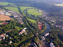
The Danube actually forms 1.4 km east of Donaueschingen in the German Black Forest at the confluence of two streams, the Brigach (right) and the Breg (left), as recalled by the German school tune «Brigach und Breg bringen die Donau zu Weg» [The Brigach and the Breg they bring the Danube their way], which is equivalent to the French saying "small streams make great rivers". Hydrologically, the more distant source of the two, the Breg near Furtwangen, is known as the source of the Danube, but also the spring from Donaueschingen. The Danube first heads in a southwesterly direction, passing through the small towns of Pfohren and Neudingen (approx. 700 inhab.), where it turns west. It soon reaches the small town of Geisingen (6,202 hab.), where it begins to head slightly northwest, a long stretch in which it will border the south southern foothills of the Swabian Alb, opening a narrow and winding valley flanked by almost vertical walls covered by coniferous forests. After Immendingen (6,353 inhabitants) begins the Upper Danube Nature Park, a protected area of 135 000 ha established in 1980, which protects the river from Immendingen to Ertingen, an area where there are many castles and remains of fortresses.
Then the Danube reaches Tuttlingen (36,102 hab.) and Mulheim an der Donau, where it describes a pair of wide meanders in an area protected as a reserve natural Buchhalde-Oberes Donautal and receives from the left, coming from the north, the short river Bära (12.7 km. It continues through the small towns of Fridingen (3141 hab.) and Beuron (650 hab.) —where is the Abbey of Beuron—, Gutenstein (512 hab.), and after receiving the Schmeie on the left, he arrives at the city of Sigmaringa (17,125 inhab.), famous for its Sigmaringen Castle, which was the seat of the principality of Hohenzollern-Sigmaringen until 1850 and is still owned by the Hohenzollern family. It was also the last seat of the collaborationist government Philippe Pétain's French at the end of the World War II, from September 1944 to April 1945.
Follow the Danube through Sigmaringendorf (3646 hab.) —where it meets short Lauchert (60.4 km)—, Scheer (2,498 inhab.) and Blochingeny, where the Blochinger Sandwinkel nature reserve is located, already in the immediate vicinity from Mengen (9933 hab.), where it receives the first of its tributaries from the right, the river Ablach (20 miles). Continue through Hundersingen (where the Heuneburg museum is and where it meets the river Ostrach on the right, from 33.1 km), Binzwangen and Riedlingen (10,580 inhab.), where there are two nature reserves, Ofenwisch and Flusslandschaft Donauwiesen. In this section it receives two short rivers on the right, the Schwarzach (22.2 km) and the Kanzach (25.8 km), having passed through Unlingen (2439 hab.). At the end of the reserve, in Zwiefaltendorf, it meets on the left, coming from the northeast, the short Zwiefalter Aach (8.9 km). It continues its advance reaching Rechstein, and after receiving the Grobe Lauter on the left, it passes through the small towns of Obermarchtal (1311 hab.) —where the abbey is from Obermarchtal, founded in the XI century and since 1500 has the status of imperial abbey—, Untermarchtal (878 hab.), Munderkingen (5384 hab.), Rottenacker (2,195 inhab.) and reaches Ehingen an der Donau (26,293 inhab.), where it meets the river Scmiech on the left (25.4km). The Danube continues and reaches Öpfingen (2,362 hab.), where it meets the river Riss on the right, and continues through Oberdischingen (2,152 inhab.), Erbach (13,684 inhab.), where it hosts the Rot, Wiblingen ((16,156 hab.), home to the former Wiblingen Abbey, an important Baroque complex that today houses various departments of the Ulm University Faculty of Medicine. to Ulm (126,790 inhabitants), where it receives the Ach Blau on the left and the Iller on the right (147 km), the first large tributary it receives. Ulm is the beginning of the navigable section of the Danube. Ulm flourished during the 16th century century, mainly due to textile exports. In 1803, it ceased to be an "Imperial Free City" and was absorbed by the kingdom of Bavaria. During the Battle of Ulm in 1805, in the framework of the Napoleonic Wars, the French army ambushed the invading Austrian army led by General Mack in Ulm, forcing their withdrawal. In 1810, Ulm was incorporated into the Kingdom of Württemberg, belonging to the Confederation of the Rhine. The city was severely damaged in 1944 by RAF bombing. It was rebuilt in a more modern style between the 1950s and 1960s. Ulm Cathedral is well known, a Protestant Gothic church with the highest church tower in the world (161.53 m), the University City where the Ulm School stood out, a design school founded in 1953 that quickly gained international recognition. Ulm is also known as the birthplace of Albert Einstein.

Beuron and Beuron Abbey

Aerial view of Gutenstein Castle on the Danube
The Danube in Sigmaringen

Sigmaringen Castle

View of Scheer, in a meander, surrounded by the Danube

Abbey of Obermarchtal


The Danube in Bavaria
The river Illek, which enters the Danube from the right coming from the south, is the border between Baden-Württemberg and Bavaria, the old border between the kingdoms of Württemberg and Bavaria established in 1810. This new border was the reason for opposite Ulm, on the other side of the Danube and around small towns, a new city, Neu-Ulm (58,978 inhabitants), already in the state of Bavaria. Leaving behind a small dam that feeds the Böfinger Halde hydroelectric power station and the Ulm treatment plant, the Danube continues through Elchingen (9,204 hab.) —where there was the imperial abbey of Elchingen— and Nersingen (9446 hab.) and after two other small dams (Laufwasserkraftwerk Oberelchingen) reaches Leipheim (7307 hab.), where Leipheim Castle is. A section follows where one more nature reserve has been established, "Meadows and slopes of the Danube between Leipheim and Offingen" [Donauhänge und -auen zw. Leipheim und Offingen], just before reaching the city of Günzburg (21,028 hab.), where it is almost confronted, first on the left by the Nau (21.1 km) and shortly, to the right, to the river Günz (55 km) —which has given its name to the Günz Glaciation. Nearby is the 43.5 hectare theme park Legoland Deutschland, opened in 2005 and now one of Bavaria's top tourist attractions. Shortly after, it reaches Offingen, where it receives the river Mindel on the right. Gundelfingen an der Donau (7,808 pop.), Lauingen (11,060 pop.) and Dillingen an der Donau (19,149 hab.), at the confluence of the Ilm, the Abens and the Danube. Continue through Höchstädt an der Donau (6756 hab.) —where there is a Renaissance castle—, Schwenningen (1419 hab.), Tapfheim (3828 hab.)
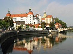
- Donauwörth (19 590.), the "Perla del Danubio bávaro" and is part of the tourist circuit called "El Camino Romántico" or "La Senda Romántica" (Romantische Straße), in the confluence with the rivers, on the left, Kessel and Wörnitz River (Rom.132 km) and on the right, Zusan and Schmutter. He arrives in Marxheim, in the confluence on the right with the river Lech (285 km), an important river that arrives from the imperial capital of Augsburg, to some 30 km South. After passing through Bertoldsheim, where there is another small hydroelectric dam (Laufwasserkraftwerk Bertoldsheim), and then receiving left to the Ussel River, arrives in Bergheim and then Neuburg an der Donau (29 793.), the capital of the Duchy of the Palatinate-Neoburg, which was part of the Holy Roman German Empire.
- Ingolstadt (137 392.), where in 1472 the university of Ingolstadt was founded, the first Bavarian university. It's Audi's headquarters. On leaving Ingolstadt is the natural reserve of Donauen an der Kälberschütt, with the wildlife shelter of Franziskanerwasser. Then follow the small towns of Großmehring (7278.), Vohburg (8399.), Pförring (3849.) and Neustadt an der Donau (14 604.), a spa town with thermal waters in Bad Gögging.
Then follows a stretch of gorge, where the Weltenburg Abbey is located, in a bend in the river, the oldest abbey in Bavaria and the oldest brewery abbey in the world.
- Kelheim (16 842.) in the confluence with the Altmühl. Rin-Meno-Danubio channel input (a channel of 171 km of length inaugurated in 1992). Its greatest attraction is the Befreiungshalle ("Sala de la Liberación", the work of Leo von Klenze), a neoclassical historical monument on Mount Michelsberg. There is also the entrance of the cnal of Ludwig (or more precisely the channel of King Ludwig) a small channel of gálibo (only allows the transit of ships of 32 m × 4,50 m) 178 km long, connecting the Danube with the Main near Bamberg, serving Nuremberg, finally connecting the Rhine and the Danube. It was built between 1836 and 1842 and entered service in 1845, being abandoned in 1950 by the destructions of the Second World War.

- Regensburg (Ratisbona)153 094.), capital of the administrative region of Alto Palatinado and the fourth most populous of Bavaria, further north of the Danube river in the confluence of lDanubio and Regen (169 km) and where he also receives the Naab (165 km). Here was built a first stone bridge crossing the Danube in just eleven years (ca.1135-1146). Luis VII of France and his army used it to cross the Danube on their Way to the Second Crusade. It served as a model for other stone bridges built in Europe in the 12th and 13th centuries and was the only bridge crossing the Danube in Regensburg for approximately 800 years, until the construction of the Nibelungen Bridge. For centuries it was the only bridge over the river between Ulm and Vienna, which made Ratisbona an important center of commerce and government.
- Straubing (47 791.) (where he receives the Allachbach), then follow Bogen
- Deggendorf (33 721 hab.), the abbey of Metten founded in 766 and to which Carlomagno doto in 792 of imperial immediacy and Luis el Piadoso in 837. The little receives on the right to the river Isar
- Vilshofen an der Donau (16 758.), where it receives on the left to the river Vils
- Passau (52 803 there.), "the city of the three rivers", where in 1552 Carlos V, emperor of the Holy Roman German Empire, signed the Peace of Passau to guarantee the freedom of worship to the Protestants of Germany.
In Passau, in the Dreiflüsseeck, it is first the Ilz (62 km) which flows left into the Danube and right after it is the Inn (or Eno) (517 km), right. the Ilz, which comes from a swampy region, is dark brown. The Danube has these three colors long after the confluence. The predominance of the green water of the Inn once the three rivers meet is due, less to the great flow of the Inn (738 m³/s compared to the 690 m³/s of the Danube) during the thaw —the Danube carries more water than the Inn during the seven months from October to April—, as well as the significant difference in depth between the Inn and the Danube (1.90 m for the first against 6.80 m for the second). In fact, the water from the Inn "floats" on the Danube.
Neoburg Palace on the banks of the Danube

The Danube at its pass through Ingolstadt (see the New Castle at the bottom)

Weltenburg Abbey,

The Befreiungshalle from the Danube Gorges

The Danube in Regensburg

Confluence of the Isar and the Danube

The river in Vilshofen an der Donau

The river in Neustadt


.JPG)


In Austria

.jpg)
No country is more closely associated with the Danube than Austria, as reflected both by its popular nickname of the "Danube Monarchy"—given to the Austro-Hungarian Empire because it stretched over about 1300 km of the river—, like the national waltz of The beautiful blue Danube.
Austria now has only 350 km of rivers on its territory, which puts Austria in sixth place among riparian countries. On the other hand, the rivers of almost the entire country feed the Danube and therefore the Black Sea. Only the Land of Vorarlberg is part of the Rhine basin (North Sea), as well as a very small part of the northwestern Land of Lower Austria that feeds the Lainsitz (Vltava (Moldau) → Elbe → North Sea).
The Danube runs through only two of the Austrian states, Upper Austria and Lower Austria. The most important Austrian tributaries of the Danube are all on the right bank, Inn (on the border with Germany), Traun, Enns, Ybbs, Traisen, Vienna, Schwechat and Leitha, which was historically important because it served as the border with Hungary until 1921; and from the left bank, the Aist and the Kamp arrive.
In Austrian territory, the course of the Danube is marked by the construction of eleven hydroelectric dams, which have dammed large areas.
In Upper Austria

As soon as we pass the German city of Passau, there comes a stretch of about 30 km in which the Danube will mark the German-Austrian international border, Germany on the left bank, to the north, and Austria on the right, to the south. The Upper Danube Valley (Obere Donautal), also called Upper Danube or Danube Gorge (Donaudurchbruch), is the section of the Danube that crosses the Bohemian Massif, between the cities of Passau and Aschach, and which separates the Sauwald (the Transdanubian part of the massif) from the highlands of the central Mühlviertel (one of the 41 spatial units of Upper Austria). The area is protected as a Natura 2000 area, Upper Danube and Aschach Valley (Europaschutzgebiet Oberes Donau- und Aschachtal ) and Upper Danube Valley (Europaschutzgebiet Oberes Donautal ).
In this section the river passes in front of the small towns of Freinberg 1,433 hab. and Achleiten Zollamt (AUT) and Högl (ALE). Then comes a stretch of German shoreline of about 10 km that is protected as a nature reserve of Donauleiten Passau bis Jochenstein, where it receives, in the small town of Erlau, on the left, to the namesake Erlau (33.7 km). On the opposite bank, it passes the Unteresternberg hab., where it welcomes the short Großer Kösslbach (17 km). It continues its slow progress past small towns, first Dietzendorf and Pyrawang (AUT), then Obernzell (ALE, with 3763 inhab.) and again Kasten, Roning (AUT). It then reaches the Kraftwerk Jochenstein dam and shortly after the Donauradweg, where it receives the small Dandlbach on the right, at the point that marks the end of the border section, as the Danube enters the state of Upper Austria.
As soon as it enters Upper Austria, it passes in front of Engelhartszell (922 inhabitants) and Schattenthal and receives, on the left, the Rannabach river in Niederranna 1,288 rooms, where the Global Hydro Energy GmbH factory is located. It continues its progress through Wesenufer (220 hab.) and Waldkirchen am Wesen (1185 hab.). Then it arrives at the "Schlögen loop" where the Danube turns 180° twice in a section gorged in the Bohemian massif where in about 3 km it seems to go back to return to recover the general direction west. It is the largest forced meander in Europe and in 2008, the local population considered the loop one of the "natural wonders of Upper Austria" among 22 proposals. Three ferries sail here and allow the crossing, as there are only trails and bike path on one of the banks.
It reaches Obermühl an der Donau (where it meets the Kleine Muhl on the left) and where the Getreidespeicher, a place of historical interest, is located. Follow Haibach ob der Donau (1289 hab.), Donauleiten, Untermühl hab. (where it meets the Große Muhl on the left) and after passing through the Kraftwerk Aschach dam, it reaches the village of Aschach an der Donau (2167 hab.), where the canyon section ends and the Danube flows out into the plain. It passes the towns of Feldkirchen an der Donau (5,395 hab.), Eferding (4,259 hab.), Goldwörth (813 hab.), Ottensheim (4738 hab.) and Wilhering (5919 hab.), where there is a new dam that feeds the Donaukraftwerk Ottensheim-Wilhering. A new canyon section follows, a short section of just over 6 km, from which it leaves through the small town of Zaubertal 804 inhabitants, to arrive, a little more than 70 km from the border, to the city of Linz (206,595 inhab.), the third-largest city in Austria and the Upper-Austrian capital.
- The High Austrian Danube before Linz

Obernzell

The river in Engelhartszell

In Wesenufer

Eferding airfield


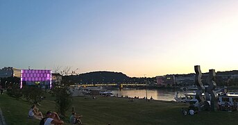
Linz is a large city that has developed on both banks of the river, connected by the Nibelungen bridge. The city was chosen in 2009 as the European Capital of Culture and since then it has become an important cultural focus —since December 2014, it is a member of the UNESCO Creative Cities Network (UCCN)—, with an important festival of electronic art. The city has taken advantage of the riverbanks to build some outstanding contemporary buildings: Brucknerhaus (1974), Lentos museum (2003), extension of the château museum, Ars Electronica Center (2009).
- The Danube in Linz

The wide bridge of the Nibelungos

Château de Linz
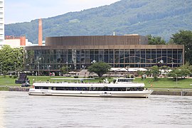
The Brucknerhaus (1974)
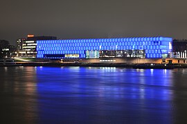
The Lentos Museum, opened in 2003, illuminated by blue

Ars Electronica Center (2009)
Danube shores


Past Linz, the Danube meets the river Traun (153 km) from the right, almost at the confluence of which is the city of Ebelsberg (10,804 inhab.) (today a district of Linz), and on the opposite bank, Steyregg (4,932 inhab.).
Then it follows the Danube off Luftenberg an der Donau (4,279 hab.)), in a newly dammed section, at the Abwinden dam, near the namesake town of Abwinden. Shortly after, it reaches the city of Enns (11,940 inhab.), located at the confluence with the River Enns, which flows in from the right from the south, marking the border between Upper and Lower Austria. Enns is located in an enclave of certain strategic value and the Roman camp of Lauriacum was founded there, where 6,000 soldiers were stationed. The Roman camp of Lauriacum was operational in the 2nd and 3rd centuries. The adjacent settlement (today: Lorch) was granted municipium privileges in 212 by Emperor Caracalla when it had about 30,000 inhabitants. Enns was also the first Austrian town to receive, in 1212, a charter granting it city privileges (Stadtrecht).
Across the Danube, facing the mouth of the Enns is the small town of Mauthausen 4,924 pop., a town infamous for being the site of the concentration camp of Mauthausen-Gusen during World War II. Mauthausen was declared a national memorial site in 1949 and Bruno Kreisky, Chancellor of Austria, officially opened the Mauthausen Museum on 3 May 1975, 30 years after the liberation of the camp. A visitor center, designed by architects Herwig Mayer, Christoph Schwarz and Karl Peyrer-Heimstätt.
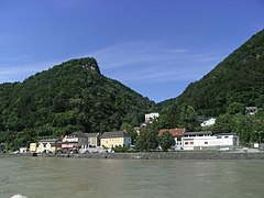
From Enns the Danube will be, for a stretch of just over 40 km, the interstate border (until past the small town of Sarmingstein, only 137 hab.). In this border section the river runs through a very fertile plain, passing in front of Au an der Donau (908 hab.), Perg (8837 rooms), Wallsee (2190 rooms) and Ardagger (BA, 3538 inhab.). Here begins the section of the Strudengau, the deepest part of the Danube in Austria, a meandering valley about 25 kilometers long, narrow and wooded, which begins on the north (left) bank in the village of Saxen (Upper Austria) — where the castle of Dornach is, and on the south bank in Ardagger (Lower Austria), and which extends downstream to the towns of Persenbeug and Ybbs an der Donau. In this canyoned section, which begins with Dornach Castle overlooking the river, the Danube passes through Grein (2,910 hab.) (where Greinburg Castle is), Struden (221 rooms), Sankt Nikola an der Donau (762 rooms), the ruins of the tower of Sarmingstein and Hirschenau, where the border section ends and enters the state of Lower Austria.

- The High Austrian Danube after Linz
Flood stations in Feldkirchner Badeseen
Mauthausen

Wallsee
Sarmingstein

Dornach Castle, beginning of Strudengau

Defensive Castle in Struden

Sankt Nikola an der Donau


In Lower Austria

.JPG)
The Danube still has to travel about 8 km of the canyoned section of the Strudengau until it reaches a new dam, which feeds the Ybbs-Persenbeug hydroelectric power station, the first of its kind built on the Austrian side of the river. Immediately afterwards it reaches the small town of Persenbeug, facing, on the other bank, Ybbs an der Donau (5627 hab.), where the Danube receives from the Left to Ybbs River (130 km). The city, found during the Middle Ages at the intersection of important trade routes - the outlet of the Erzberg iron river and the salt of the Gmunden region - acquired an important economic role and soon had the status of city in 1317. In 1858, the connection with the Austrian railway network made it lose its importance as a river port.
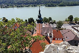
The Danube already in a wide valley borders from here on the southern foothills of the Bohemian massif, in the Waldviertel region. On this section you will pass the small towns of Marbach an der Donau (1691 hab.), Krummnußbaum, the twin Pöchlarn (3948 hab.) and Klein-Pöchlarn ( hab.), Ebersdorf (1306 rooms) and Weitenegg (only 42 rooms). Here is a new dam feeding the Donaukraftwerk Melk, just before the city of Melk itself (5630 pop.) with its imposing abbey. After passing through Emmersdorf an der Donau hab. and Schönbühel an der Donau (304 hab.), where the castle of Schönbühel is located, the Danube enters a stretch of almost 36 km in the middle of one of the most picturesque landscapes of its course, the Wachau (classified as a World Heritage Site by UNESCO). St. Michael (market town Weißenkirchen in der Wachau) with the fortified church of St. Michael or "Mother Church of the Wachau"


Aggstein Castle, Spitz 1,569 rooms, Mitterarnsdorf 1,054 rooms, Wösendorf in der Wachau, Weißenkirchen in der Wachau (1395 hab.), Rossatz-Arnsdorf (1054 hab.), Rührsdorf (hab.) and Dürnstein (840 hab.), where Dürnstein Abbey is located, founded in 1410 and whose tower of the 18th century baroque church is considered the symbol of the Wachau. After passing through Mautern an der Donau (3,539 hab.) the Danube reaches the city of Krems an der Donau, the fifth most populous city in the state (25,036 inhab.), located at the confluence with the Krems River (64.5 km). Chremis, as it was called in medieval times, was an important river communication hub and received city rights already under the administration of the House of Babenberg in the 11th and 12th centuries; at that time it was almost as big as Vienna. The urban privilege of Krems and Stein was verified again during the Habsburg rule in 1305. Emperor Frederick III conferred on the city the coat of arms of the Holy Empire, the double-headed eagle, on April 1, 1463. The city Now it can be considered as a fair city with industry and as a destination for numerous tourists and students. Krems is also the main producer of Marillenschnaps, an apricot brandy.
The slow flow of the Danube continues, passing in front of Krems-Hollenburg, Traismauer (6,224 inhabitants) and Altenwörth, where there is a new dam, the Altenwörth hydroelectric power station. Soon it reaches the city of Zwentendorf (4097 hab.), where the Zwentendorf Nuclear Power Plant (AKW Zwentendorf) is located on the right bank —completed but which never came online after an unfavorable ruling in the 1978 referendum on nuclear power in the country—and also the chemical plant, Donau Chemie Aktiengesellschaft. Then the Danube reaches Tulln (16,230 pop.), known as Blumenstadt, the 'city of flowers' 39;, where it receives the Grosse Tulln river from the right and where it is crossed by a modern cable-stayed bridge with a single pylon that entered service in 1996 (Rosenbrücke). The city has an important sugar company, Agrana Austria, and important fairs (camping equipment and boats) are held here, and it is the headquarters of various institutions of the state of Lower Austria, such as the fire department or the disaster response service.. The Federal Aviation School is also located in Tulln.
Reaches Stockerau (16,875 pop.), Korneuburg (13,331 pop.) and Klosterneuburg (27,500 pop.), just outside the Austrian capital Vienna (1 911,191 inhabitants), already close to the border with Slovakia. The city was for centuries the largest and most important city on the Danube, but today it must share this status with Belgrade and Budapest. The river allowed the city to become an important economic place and even today the Danube is an important commercial axis between the East and the West. The city takes its name from a tributary, the Vienna (Wienfluss), which joins the Danube at this point. Vienna is also the headquarters of the International Commission for the Protection of the Danube (Internationale Kommission zum Schutz der Donau, IKSD), founded in 1998.

To reduce the harmful effects of flooding, the river has been artificially regulated there. A new channel has been prepared, parallel to the one already channeled before, in a section of more than 20 km that leave the island of the Danube in between, with a width of only between 70 and 210 m, which have been conditioned as a recreational area with bars, restaurants and discos. It has facilities for sports such as skating, cycling, swimming and canoeing, and there is a beach nicknamed the "Copa Cagrana", a humorous allusion to the Copacabana in Rio de Janeiro in the Kagran neighborhood, in the center of Vienna. At the northern and southern ends of the island there are long nudist beaches.
Pass near Vienna-Schwechat Airport, Orth an der Donau hab., Haslau an der Donau room, Schloss Petronell room, Bad Deutsch-Altenburg room and Hainburg an der Donau (6837 hab.). As soon as you leave the small town behind, you arrive at the area known as the Gates of Hungary or Devín, a natural gate in the valley where the Danube will be in a short stretch the Austro-Slovak border (7.5 km) to enter Slovakia and cross the capital Bratislava.
Passau, the Devin Gate, and the Iron Gates divide the Danube River into four distinct sections.

The Danube from the parish church of Marbach an der Donau

Pöchlarn
Weitenegg Ruins

Strudengau

The Danube in the Wachau: izqda, Bacharnsdorf, Mitterarnsdorf, Hofarnsdorf and Oberarnsdorf; dcha., St. Michael and Spitz an der Donau

Weißenkirchen at Wachau

Castle of Schönbühel
Aerial view of Tulln

The Rosenbrücke Bridge in Tulln


.JPG)

.jpg)


In Slovakia


The Danube runs for a short stretch through Slovakia, passing through three of the country's eight regions (kraje)—Bratislava, Trnava, and Nitra—though it barely enters the country, a short stretch of about 22.5 km in the capital, the rest of its course being the border, first with Austria (7 km) and then with Hungary (142 km).
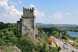
The Danube enters Slovakia by receiving from the left, arriving from the north, one of its main tributaries, the long Morava (or March, in German) river (358km). The confluence is still watched over by the now-ruined Devín Castle, standing on the outskirts of Devín (1,679 pop.), a town built into the hillside of the Devínska Kobyla mountain, the southwestern spur of the Devín Carpathians (part of the Lesser Carpathians) that the river will skirt to the south. This is a stretch of border with Austria of just over 7 km where there are no towns, just the small Austrian town of Wolfsthal, one kilometer from the Danube which also has its castle, Wolfsthal Castle. On the Slovakian shoreline, the Zátoka pod Slovanským ostrovom nature reserve has been established. This section of the Danube was part of the so-called Iron Curtain, which separated Western Europe from the Eastern Countries between 1949-1989. The curtain fell on the Morava, one of the oldest and most stable European borders—the eastern border of the Carolingian Empire with the Avars around the year 800, from the X border of the March of Austria, later the Duchy of Austria, with the Kingdom of Hungary—, and followed the current Austro-Slovak, formerly Austro-Czechoslovak border.
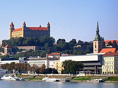
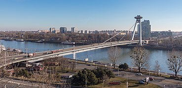
The Danube flows entirely into Slovakia as it reaches the small Hungarian plain (Malá dunajská kotlina), just outside Bratislava (437,725 inhab.), in the Riviera district. The capital, just 45km from Vienna, originally developed on the Left Bank, dominated by the Bratislava Fortress overlooking the river, although there are now districts on the other side of the Danube, which in this section is already about 300 m wide.
Bratislava has also taken advantage of the riverbank to lay out green spaces, such as the River Garden (Vodárenská záhrada), the Bratislava Botanical Garden and River Park (left) and the Sad Janka Kráľa (right), and erect great buildings like the cathedral of San Martin or the Slovak National Museum. The city has a marina, the Prístav Bratislava. Right there, the Danube has a small distributary, the Little Danube, which will regroup after traveling 135 km with the main course at Komárno, more than 85 km in a straight line. In this way, the largest river island in Europe, Žitný ostrov ('Big Rye Island'), with an area of 1886 km². Following the main course, still on the capital's right bank, two nature reserves have been established: Soví les and Starý háj and on the left there is a beach area, the Pri Kopáčskom ostrove.

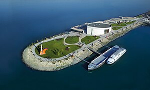
On the outskirts of the capital, the Danube has dammed in the dam of the Čunovo power station (1,532 inhabitants), between that town and Hamuliakovo (2,335 hab.), on the opposite shore, a reservoir that has been used to build a marina and whitewater facilities, as well as a modern museum of private modern art on a peninsula in the reservoir, Danubiana Meulensteen Art Museum, Danubiana, which has an outdoor sculpture garden, opened in 2000 and temporarily out of service.
- The Danube in Bratislava

The cathedral, before on the river and now separated by a horrific knot of the new bridge
Bratislava fortress dominating the river

The Slovak National Museum
Bridge of the Slovak National Insurrection (1967-1972), with a viewer and a restaurant on the only pilona
The new Danubiana art center


Slovak-Hungarian border


The point where the Danube leaves the capital region and enters the Trnava region roughly coincides with where, on the right bank, the Danube becomes the border between Slovakia and Hungary, a flatland area floodplain where the westernmost branch is the border and where the main channel runs for about 35 km entirely in Slovakia. Those plains, now regulated by the Gabčíkovo-Nagymaros dams, are a major tourist attraction. On the Slovakian bank, to the left, is the small town of Šamorín (13,350 hab.), which, after the Mongol invasion, was settled by & #34;guests" Germans who administered the city. This German minority received the royal privilege of applying the law of Pressburg (now Bratislava) and lived in the city until the end of the Middle Ages. The settlement was a prominent port on the Danube during the Middle Ages and the commercial center of the Isle of Rye. Agriculture also played an important role in the development of the city, and thanks to that prosperity, its citizens enjoyed a vigorous trade with many shipyards on the Danube. However, with the rise of Pressburg, the city's importance began to decline. Šamorín finally lost its right to free royal city status granted in 1405 during the reign of the Hungarian King Sigismund.
It then follows the river past the small Slovak towns of Kyselica (190 hab.), Horný Bar (1231 hab.), Trstená na Ostrove (573 hab.), Baka (1095 hab.), Gabčíkovo (5473 hab.), Ňárad (625 hab. ) and Sap (512 hab.), where after meeting the distributaries of the floodplain that marked the border, the main channel is again the Slovak-Hungarian border.
In the border section, after passing the small Slovakian town of Medveďov (539 inhabitants) it enters the Nitra region. On the Hungarian bank, it runs to the left of the Hungarian city of Győr (132,034 inhabitants), barely five kilometers from the Danube. Győr is the largest city in northwestern Hungary, the capital of Győr-Moson-Sopron County. It is located on the important highway linking Budapest and Vienna, halfway between both. The Danube then reaches the Hungarian city of Gönyű (3099 inhab.), where it receives the Raab River (322 km), which has just passed through Győr. On the Hungarian bank, the Danube enters the county of Komárom-Esztergom and then reaches two new twin cities, Komárno (Slovakian, but populated by the Hungarian minority, 33,751 inhab. )-Komárom (Hungarian, 18,805 inhab.), where the Váh River, the main Slovakian river, meets the Danube. The fortification systems at the confluence of the Danube and Váh rivers in Komárno-Komárom, have been proposed since 2007 in the Hungarian Tentative List.
Follows another stretch with small towns on both banks (the Slovaks, Iža (1703 inhab.), Patince (448 hab.), Radvaň nad Dunajom (704 hab.), Moča (1122 inhabitants) and Kravany nad Dunajom (710 inhabitants); and the Hungarian Almásfüzitő (2047 hab.), Dunaalmás (1547 hab.), Neszmély (1269 hab..), Süttő (2023 hab.), Lábatlan (4839 hab.), Nyergesújfalu (7255 hab.) and Tát (5280 hab.), in the northern end of the Gerecse mountains, which reach the river The Danube again reaches two twin cities, the Slovakian Štúrovo (10,186 inhab.) and the Hungarian Esztergom (28,144 inhab.).
Then, after receiving the Hron River along the Slovakian bank, it reaches the Burdov Nature Reserve and shortly after, after passing through the village of Chľaba (696 hab.), reaches the confluence with the small Ipeľ (in Slovak or Ipoly in Hungarian) which marks the end of the border section and where the Danube enters Hungary.
- The Danube at the Slovakia-Hungria border section

Bridge view Maria Valeria and Štúrovo, from Esztergom

Cathedral of Esztergom in Hungary, in the Danube

Cathedral of Esztergom


In Hungary


The Danube runs through 275.2 km entirely in Hungary (in addition to the 142 km on the border with Slovakia) traversing, or bordering, seven of the country's nineteen counties —Győr-Moson-Sopron, Komárom-Esztergom, Pest, Fejér, Bács-Kiskun, Tolna and Baranya— in addition to the city- capital Budapest. The river enters the country at its north-western end and after heading east, after the "Danube bend", it leaves the mid-mountain and enters the great Hungarian plain, of which the river marks the western limit. Then it crosses the country from north to south, clearly delimiting two zones: Transdanubia, to the east (with three regions, Central, Western and Southern) and the western part, with four regions (Northern and Central Hungary, and the Great Northern Plain and Southern).
After traversing the border section, from the extreme north-west of the country to the northern central part, the Danube enters Hungary completely, running between the Börzsöny mountains to the north and the Pilis mountains to the south. It marks the intercounty boundary between Komárom-Esztergom (E) and Pest (W), a short stretch of just over 9.0 km passing in front of the towns of Szob (2660 hab.), Zebegény (1214 hab.), Pilismarót (2091 hab.) and Dömös (1116 hab.). It then enters Pest County and passes between the twin cities of Visegrád (1841 pop.) and Nagymaros (4717 inhab.). Here the Danube has an important distributary, the Szentendrei-Dunaag, which rejoins the main course after traveling more than 35 km downstream, at the gates of the Hungarian capital, leaving in between the large island Szentendre, the second largest island on the Hungarian side of the river, about 31 km long with a maximum width of 3.8km. The island is located within the Danube-Ipoly National Park and on it are the small towns of Tahitófalu, Pócsmegyer, Szigetmonostor and Horány.
The main course of the Danube continues its advance passing in front of the small Kisoroszi (962 inhabitants), Kismaros (2009 hab.) and Verőce (3758 hab.), until reaching the city of Vác (32,828 inhab.). Here the river describes the "Danube bend", turning 90° in a southerly direction (a direction it will maintain for almost 500km, instead of west to east as it did up to that point). Continue past Göd (18,225 pop.), a spa town, and Dunakeszi (43,490 pop..), and after traveling a little more than 50 km from the border, reaching the most populated city on its way, Budapest (1,752,286 inhab.), the capital of Hungary.
- The Danube in Hungary before Budapest

View of the citadel of Visegrád

The “Danubium Rejoin”

View of Göd

View of the city-suburb of Dunakeszi

View from Verőce to the Banda del Danubio

Kisoroszi, view from the other side of the Szentendrei-Duna branch


The Danube divides the city into two parts, Buda and Pest. At the entrance to the city, in the middle of the Danube, is Margaret Island —named in memory of Margaret of Hungary (1242-1270), the daughter of Bela IV of Hungary— of 2.5 km long and with an area of 0.965 km², which is a leisure area with parks, very popular both for tourists and for the neighborhood. Bridges have been built at both ends of the island: in the north, the Árpád bridge and in the south, the Margarita bridge (1872-1876).
There are many buildings that flank both banks, highlighting in Pest the Parliament, the Hungarian Academy of Sciences, the Central Market of Budapest, the Gresham Palace (now the Four Season Hotel), the Vigadó Concert Hall, the Corvinus University and on the opposite bank, the castle of Buda. This has earned the city to be declared a World Heritage Site in 1987 ("Budapest with the banks of the Danube, the Buda Castle district and Andrássy Avenue").
- Some Budapest bridges (water down)

Megyer Bridge (2008)

Margarita Bridge (1872-1876), at the end of Margarita Island

Chain Bridge (1839-1849)
Elizabeth Bridge (1961-1963)

Freedom Bridge (Budapest) (1894-1896)


South of the capital, in the Csepel district (76,320 inhab.) there is a new distributary, the Ráckevei (Sóroksai)-Dunaág or « Little Danube» (Kis-Duna), which emerges from the left bank and forms a large island, the island of Csepel, elongated in shape, with a length of 48 km in a N-S direction and an area of 257 km² and reaching the border between the counties of Pest (to which the island belongs), Bács-Kiskun and Fejér. At the beginning of the island are the facilities of the Free Port of Budapest, inaugurated in 1928 and which is the largest port in the country, with an important container terminal built in 1972 and in continuous expansion. On the Little Danube, both at the entrance in the north and at the exit in the south, two locks have been built to regulate the water level. The main course, known as the "Great Danube" (Hungarian Nagy-Duna), passes in front of Százhalombatta (18,241 inhab.) and Ercsi (8065 inhabitants), now suburbs of the capital, to be once again the inter-county boundary, this time between Fejér (E) and Pest (W). It continues opposite the small towns of Adony (3880 hab.), Kulcs (2735 hab.), Rácalmás (4572 hab.), located on a branch of a large island, protected as Rácalmási-szigetek Természetvédelmi terület, on the opposite shore of which gather the Ráckevei Dunaág, in an area declared a nature reserve Ráckevei Dunaág Torkolat. From that confluence the Danube continues to be the intercounty boundary, this time between Fejér and Bács-Kiskun. Continue along Dunaújváros (44,200 hab.), where the Pentele Bridge, an arched structure supporting the four lanes of the M-8, was inaugurated in 2007, and that unites it with Dunavecse (3769 hab.), on the other bank of the river. It then passes through Apostag (2009 hab.) and from there it will be the boundary between Tolna County and Bács-Kiskun. It passes the towns of Dunaföldvár (8593 hab.), Bölcske (2754 hab.), Harta (3239 hab.), Dunapataj (3012 hab.) and Paks (18,788 inhab.). Just over 4 km from the Danube is the city of Kalocsa, one of the oldest cities in Hungary and episcopal seat of one of the country's four Catholic archbishops. Among its buildings are a beautiful cathedral, the archiepiscopal palace, an astronomical observatory, a seminary for priests and schools for the training of teachers. The residents of Kalocsa and their extensive common lands are mainly employed in the cultivation of paprika, fruit, flax, hemp, and cereals.
Continue south through small Gerjen (1,200 rooms) and Fajsz (1,621 rooms), until reaching the Gemenc National Forest (Gemenci erdő), a floodplain forest in a stretch of about 35 km span> on the right bank of the river, from which about 180 km² is regularly flooded, making it unique not only in Hungary, but also in the whole of Europe. In the middle of this protected section, on the other side of the Danube, the city of Baja (34,788 inhabitants). After passing through the twin towns of Dunafalva (919 hab.) and Dunaszekcső (1796 hab.)—a small village built largely on the site of the important Roman camp and settlement of Lugio—the river enters Baranya county, which it will not leave until it leaves the country. Arrive then in the city of Mohács (17,089 hab.), known for two famous battles, the Battle of Mohács (1526) and the Battle of Mohács of 1687, which represented the beginning and the end, respectively, of the Ottoman domination of Hungary.
After crossing the entire Danube-Drava national park, established in 1998 by merging several areas that have already been declared protected (such as the Gemenc forest and the Béda-Karapancsa section), in the interfluve between the Danube and the Drava with a 494.78 km² protected area on both banks of the Danube, leaves Hungary.
- The Danube in Hungary after Budapest

The modern Pentele Bridge, opened in 2007, connecting Dunaújváros and Dunavecse

The Beszédes József bridge in Dunaföldvár, opened in 1930, which supports the National-52
The river in Dunaszekcső


In Croatia

With only 137 km, Croatia has, after Moldova, the smallest section of the Danube in its territory.
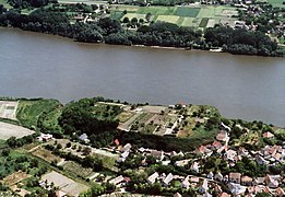
The river enters Croatia in a short stretch of just 7 km, ending when it arrives opposite the small town of Batina, a Danube port on the the meeting point of Croatia, Hungary and Serbia. The border here will continue in a very winding layout of old meanders, now abandoned by the Danube, which has traced a new course, and which intermittently enters Croatia, or is the border with Serbia. They are short loops in the Croatian national reserve of Posebni rezervat prirode Gornje Podunavlje and further on, the special nature reserve of Gornje Podunavlje. After receiving from the right, coming from the west, the Drava River —which some 20 km up above has just passed through the important city of Osijek—, its second tributary longer, on the Croatian side are small Aljmaš, Erdut and Dalj, before reaching Vukovar, which was badly damaged during the Croatian War.
Dispute area between Croatia and Serbia
For a length of 217 km, the border between Croatia and Serbia runs roughly north-south. Starting from the north, it begins at the tripoint between the two countries and Hungary and bends east, to the Serbian town of Bačka Palanka (pop. 28,239). It then turns south, then west, and south again, until it joins the tripoint with Bosnia-Herzegovina.
But the two countries oppose each other over the course of their natural border of 137 km along the Danube, of which only 40 km, bounded by the thalweg, are recognized by both states. For a stretch of more than 97 km Croatia claims the former borders between the Hungarian counties of Baranya and Bács-Bodrog since the time of Austria-Hungary, which were they date back to a time when the course of the river was different from the current thalweg. This dispute has resulted in several Croatian claims on the Serbian side of the river, as well as a terra nullius on the Croatian side that is not claimed by either country (but is claimed by three countries). micronations: the tax haven of "Liberland", the Danubian ecological principality of Ongal and the kingdom of Enclava).
In Serbian


Croatia (right bank) initially shares the Danube with Serbia (left bank). Near Bačka Palanka (28,239 inhab.), the Danube loops and then enters Serbia in a south-easterly direction, away from the Croatian border, skirting the northern foothills of the Fruška Gora mountain, where a national park has been established since 1960 (when Yugoslavia still existed) in which Orthodox monasteries abound. The Danube flows through, or borders, eight of Serbia's 30 districts: South Bačka, Sirmia, Central Banat, South Banat, Belgrade City, Podunavlje, Braničevo and Bor.
Just 25 km from the border with Hungary is the first major city in Serbia, the port city of Apatin (17,352 hab.), once populated almost exclusively by descendants of German emigrants from the century XVIII until the end of World War II. Downstream of this city, the river passes through the now suburbs of Begeč (3325 hab.), Futog (18,641 inhab.) and reaches Novi Sad (250,439 inhab.). Novi Sad was founded in 1694 when Serbian traders formed a colony across the Danube from the Petrovaradin Fortress, a strategic Habsburg military outpost and today the city's iconic landmark. In the following centuries, it became an important commercial, industrial and cultural center, and has historically been known as the "Serbian Athens". The city was heavily devastated in the Revolution of 1848, but was subsequently rebuilt and restored. Today the capital of the South Bačka district, together with the Serbian capital of Belgrade, Novi Sad is an important industrial and financial center for the Serbian economy. In 1999 during the Kosovo war, its bridges suffered serious damage and for more than six years, circulation between the two parts of the city was carried out by means of an improvised floating bridge, which interrupted navigation on the Danube because it only opened three times a week. Since the commissioning of the "Liberty Bridge" on October 11, 2005, navigation on the river could be done again without obstacles.
The Danube reaches a protected area, the Koviljsko-petrovaradinski rit special nature reserve, on one of whose banks is the small town of Sremski Karlovci (8750 inhab. ). At the end of the reserve it reaches Stari Slankamen (543 hab.), just before one of its main tributaries, the long Tisza River, approaches it from the left. From this confluence to the confluence with the Cerna River, 425 km downstream, the Danube will be the southern boundary of the historic Banat area, now divided into three countries (Serbia, Hungary and Romania).
After traveling another 70 km supplementary, and passing in front of the small towns of Čortanovci (2337 hab.), Novi Slankamen (2994 hab.), Stari Banovci (5954 hab. ) and Novi Banovci (9443 hab.), reaches the cities of Zemun (168 170 inhab.) and New Belgrade (214,506 inhab.), currently incorporated into the metropolitan area of the capital. The Danube finally reaches Belgrade, the third most populous city along the river with 1.6 million inhabitants.
- The Danube in Serbia before Belgrade

The fortress of Petrovaradin in Novi Sad

The Danube from Stari Slankamen

The Danube from Sremski Karlovci

The Danube from Zemun


.jpg)


The site Belgrade now occupies has been inhabited for 7,000 years, making it one of the oldest permanently inhabited cities on the banks of the Danube. It is built around the confluence with the Sava River and its center is dominated by the imposing Kalemegdan fortress. Across the river is Borča (46,086 inhab.). Continuing its journey through Serbia, the Danube passes through the industrial towns of Pančevo (119,509 pop.) —where the Danube meets the Tamiš (354 km) and there is the Utva factory—, and Smederevo (63,028 inhab.), where the Morava flows into the Danube guarded by the Smederevo fortress. It continues its advance passing through Kovin (13,515 inhab.) and, after receiving the Great Morava River from the south on the right, it reaches Kostolac (9569 hab.), where about 2 km away are the remains of Viminacium, the Roman capital of the province of Moesia Superior. Then you pass the now partly reconstructed ruins of the Ram Fortress, built in the late 15th century, opposite the city of Banatska Palanka (682 inhab.), at the confluence with the Nera river that marks the beginning of the border between Serbia and Romania up to the Djerdap I and II dams. On the Serbian side is the Đerdap National Park which is home to Trajan's Table.
The Danube in this long border stretch passes through the small Serbian town of Veliko Gradište (6,204 inhab.) and the Romanian Moldovan Veche, before passing In front of the imposing Golubac fortress, which marks the beginning of the long gorge of the "Iron Gates".
- The Danube in Serbia after Belgrade

Fortress of Smederevo
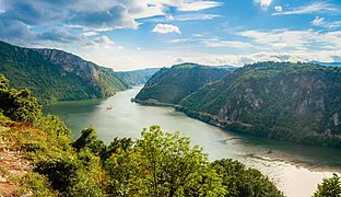
The place where the Danube is more narrow, in the national park of Đerdap

Ruins now reconstructed in part of the fortress of Ram

Fortress of Golubac


Lower Course
The Danube in its lower course runs a distance of 1075 km, between the towns of Baziaș and Sulina. It all runs through Romania, most of it as an interstate border—first with Serbia (235.5 km), then with Bulgaria (469.5 km) and the Republic of Moldova (0.6 km) and finally with Ukraine (53.9 km)—and only the final part entirely in the country. Those 1075 km, or about a third of its total length, make Romania the longest part of the river.
In the region between Bărăgan and Dobrogea, it borders the Dobrogean Plateau from the north before flowing into the Black Sea after marking the border with Ukraine. Because it crosses a multitude of natural regions, the lower course is usually divided into 5 sectors (Ujvari, 1972):
- Garganta de los Cárpatos (144 km)
- Sector of the Southern Cone566 km)
- Sector of the Pontico oriental pond (195 km)
- Predobrogean sector80 km)
- Delta sector (90 km)
The Danube drains most of the rivers in Romania, except for some in Dobrogea, and carries around 60 million tons of alluvium and 200 km³ of water year. It is also of particular importance for navigation, hydroelectric generation, water supply for industry, agriculture, fish farming, and the population in general. In the Danube floodplain there are many settlements including 18 cities —Moldavia Nouă (12,350 inhab.), Orșova (10,441 hab.), Drobeta-Turnu Severin, Calafat (17,336 hab.), Corabia (16,441 hab.), Turnu Măgurele (24,772 hab.), Zimnicea (14,058 hab.), Giurgiu (73,587 hab.), Oltenița (24,822 hab.), Călărași (65,181 hab.), Fetești (30,217 inhab.), Cernavodă (17,022 inhab.), Hârșova (9642 hab.), Brăila (216,929 hab.) and Sulina (3,663 hab.)—, being crossed by five highways and three railways.
During the years of socialism, fills were made along the Danube, making lakes like Potelu, Greaca or Nedeia disappear. These lakes retained a lot of water during floods and were an important source of fisheries. Currently, the lack of these lakes causes serious problems during periods of flooding.
Croatia-Romania border section


The river runs along the mountains of the historic Banat to the southwest, crossing the spectacular "Iron Gates", which separate the western Romanian Carpathians from the Balkans and which were dangerous with eddies before the hydraulic works of the 1970s.
Orșova (pop. 10,441) sits on a bend in the gorge, where the Cerna River meets the Danube. The city is a center of extraction of bentonite, chrome, and granite, with industries centered on power generation (the hydroelectric power station), shipbuilding and engine manufacturing, and the processing of feldspar, asbestos, quartz, talc, and wood..
Moldova Nouă (12,350 hab.)
Carpathian Gorge
Just after leaving the gorge, the Danube passes in front of the Romanian city of Drobeta-Turnu Severin, capital of the Mehedinți district that corresponds to the ancient Roman city of Drobeta. Nearby are the remains of the famous Trajan's Bridge, the largest built by the Empire. At the ford, the Danube is about 1200 meters wide. Built in just three years (103-105 AD) by the famous architect Apollodorus of Damascus, the bridge was considered the most daring work in the Roman world. Drobeta was a strategic city at the crossroads of land and river roads leading north and south of the Danube. During the reign of Septimius Severus (AD 193-211), the city was raised to the status of a colony (AD 193), giving its residents the same rights as citizens of Rome. As a colony, Drobeta was a prosperous city with temples, a basilica, a theater, a forum, a port, and craft guilds. In the mid-III century, Drobeta had a population of nearly 40,000. After the withdrawal of the Roman administration from Dacia in the IV century, the city remained under Roman occupation as the head of bridge on the north bank of the Danube to the VI century, which was destroyed by the Huns in the V, was rebuilt by Justinian I (527-565). Here the Danube river turns south and passes in front of Gruia, Pristol, Gârla Mare, Vrata, Salcia and Cetatea.
The Danube follows a pair of wide meanders, one of which is the Serbian town of Negotin (16,882 pop.), just after the second of the Djerdap dams and near the Bulgaria-Romania-Serbia tripoint, marked by the confluence with the Timok River (203 km), the border between Serbian and Bulgarian.
Border section Bulgaria-Romania

The Danube is the border of seven of the 28 Bulgarian provinces —Vidin, Montana, Vratsa, Pleven, Veliko Tarnovo, Ruse and Silistra— and of ten of the 41 Romanian districts —Mehedinți, Dolj, Olt, Teleorman, Giurgiu, Călărași, Constanța, Ialomița, Brăila and Tulcea—. Between 1954 and 2013, only the Ruse-Giurgiu Friendship Bridge, which connected the largest Bulgarian city on the river, Ruse, and the Romanian city of Giurgiu, allowed road crossing of the river, although ferries connect Vidin with Calafat, Nikopol with Turnu Măgurele as well as Svishtov with Zimnicea.
For Bulgaria, the Danube is the only waterway connecting the country with central Europe and Germany. Of the twelve Bulgarian ports on the Danube, the most important are Vidin, Lom, Oryahovo, Nikopol, Svishtov, Ruse, Tutrakan and Silistra.
Already in the Bulgarian-Romanian section, the Danube reaches the twin cities of Vidin (58,018 inhabitants) and Calafat (17,336 inhab.), connected since 2013 by the Danube Bridge II (with 4 rails and a railway line) and previously by ferry. Vidin is the capital of the Vidin province of the same name and was the capital of Ivan Esratsimir, Tsar of Bulgaria between 1356 and 1396. The Baba Vida fortress is the only well-preserved medieval castle in the country, it was the main defensive installation of Vidin and acted as the most important fortress in northwestern Bulgaria in the Middle Ages. In turn, the Calafat Customs, in the XV-XVI centuries, was the most important transit point for trade between the Romanian country and the Balkan Peninsula.

After describing a wide meander, the Danube heads in a general easterly direction, a direction that it will maintain for the rest of the Bulgarian-Romanian border section. It continues through the Bulgarian city of Lom (25,172 hab.), located at the confluence with the Lom River, which is the second river port in the country after the of Rose. It then passes, on the same Bulgarian bank, in front of Kozloduy (12,400 hab.), where the Kozloduy nuclear power plant has been in operation since 1974, which reached have six reactors in operation of which only two remain operational. In the city is the Hristo Botev Monument and a replica of the Radetzky steam-museum, both considered national tourist sites. Opposite the city, on the Romanian side, flows the important Jiu River (331 km).
It then follows the Danube through Oryahovo (5031 inhab.), opposite the Romanian town of Belchet, a small town now somewhat removed from the river, the first of a string of small towns —Călărași, Dăbuleni, (12,182 hab.) (famous for the existence of a sandy desert to the north, known as the Sahara Oltenian, with about 800 km²), Potelu, Grojdibodu, Gura Padinii, Orlea and Sucidava—will reach Corabia (16,441 hab.). Sucidava was a Roman city where the first Christian church in Romania is located, as well as the remains of an ancient Roman bridge over the Danube made of stone and wood, built by Constantine the Great and finished in 328, which linked Sucidava with Oescus (in Messiah). There is also an underground fountain that flows under the city walls and a museum where objects found in the excavations and ancient relics are exhibited.
On the opposite bank from Oryahovo, is Ostrov, the place where Hristo Botev landed with his insurgents, and then meets the Iskar River on the right (368 km), in Gigen (1984 hab.) almost opposite Corabia. Gigen is famous for having been built on the site of the important Roman colony of Oescus, the extensive ruins of which are in the northwestern part of the town and were first associated with the former colony at the turn of the century XVII.
After passing through the Romanian Gârcov (2303 hab.) and Islaz (6130 hab.), receives the important river Olz on the left, opposite the Bulgarian town of Somovit (586 inhabitants), shortly before reaching Nikopol (2882 hab.). An important city throughout its history (Roman, Byzantine, Bulgarian and Ottoman city), it was the site in 1396 of the Battle of Nicopolis, the last large-scale crusade of the Middle Ages, which in the siege of the fortress it defended Nicopolis, the united armies of Christian Europe led by the Hungarian King Sigismund of Luxembourg and several French knights were defeated by the Ottomans commanded by Beyazid I and his Serbian ally Stephen Lazarević.
Opposite Nikopolis, on the other side of the river, with a ferry service, is the Romanian Turnu Măgurele (hab. 24,772). The city appears as the port of the Principality of Wallachia but the Turks seized it in the XVI century, turning it into a ray (military brand) and retained it until 1829, when by the Treaty of Adrianople you were returned to Wallachia. But, the accumulated floodwaters and the regularization of the Danube bed in the XIX century, have caused the old port of Turnu to filled up and the modern port is now 4 km south of the city.
- The Danube before Svishtov (most southern Bulgarian-Roman border)

Port of Calafat, and Vidin

The fortress of Baba Life in Vidin, controlling the passage of the Danube

Dawn at a Lom pier. The other side is Romania.

Port over the Danube in Oryahovo (Bulgaria)

Kozloduy nuclear power station, operational since 1974

Nikopol
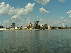
Romanian port of Turnu Măgurele


.jpg)


After passing in front of the Bulgarian Belene (8,402 inhabitants) —where the Bélene Nuclear Power Plant, the second Bulgarian power station, is semi-constructed and paralyzed— the Danube it reaches Svishtov (34,842 inhab.), its southernmost point, and from here, downstream, it will head slightly northeast. Svishtov is connected to the Romanian city of Zimnicea (14,058 hab.) by a regularly operating 24-hour Ro-Ro ferry service. The ferry shortens the road route to and from Turkey to Central and Western Europe by (140 km compared to the traditional route over the Danube Bridge at Ruse-Giurgiu (about 60 km downstream) and allows a time gain of almost four hours thus avoiding the traffic in and around the city of Bucharest.


The Danube then passes the small Bulgarian town of Vardim, opposite Vardim Island, the country's third largest river island (4.9 km²), a protected wetland and bird nesting area of national importance, partly declared a nature reserve since 1971. It continues through Novgrad, where the Yantra River empties, almost opposite the mouth, on the Romanian bank, of the Vedea River. It follows a section of the Romanian plain, passing through the small towns of Bujoru, Pietroşani, Pietrişu, Găujani, Vedea, Malu and Slobozia. It then reaches two new twin cities, facing each other, the Bulgarian Ruse (163,712 inhabitants), capital of the province of Ruse, and the Romanian Giurgiu (73,587 inhab.), capital of the Giurgiu district. Ruse, nicknamed Little Vienna, is the fifth most populous city in Bulgaria and is known for its 19th and 20th century Neo-Baroque and Neo-Rococo architecture, which attracts many tourists. The Ruse-Giurgiu Friendship Bridge, inaugurated in 1954, was, until June 14, 2013, the only bridge built on the Bulgarian-Romanian section of the Danube. Giurgiu is located in the historical region of Muntenia, between marshes and swamps: three small islands face the city and a larger one protects its port, Smarda. The rich cereal-growing land of the north is traversed by the railway to Bucharest, the first line opened in Romania, which was built in 1869 and later extended to Smarda. Giurgiu exports wood, cereals, salt and oil, and imports coal, iron and textiles. The Battle of Giurgiu, from October 27 to 30, 1595, was an important part of the Long War (1591/1593-1606), the border conflict between the Habsburg Monarchy and the Ottoman Empire over the Balkan territories.
Again on both banks there are two chains of small towns, which end in the twin cities of Tutrakan and Oltenița: on the Bulgarian side, Marten, Sandrovo, Slivo Pole, Ryahovo, Nova Cherna and Staro Selo; and in Romanian, Frăteşti, Plopşoru, Frasinu, Gostinu, Băneasa, Pietrele, Prundu, Greaca, Căscioarele and Chirnogi.
Tutrakan (8,568 hab.) is a small town remembered for being the site of the World War I battle of Turtucaia. Oltenița (24,822 hab.), built at the confluence of the Argeş River (350 km), is a medium-sized city where river cruise ships stop and lives mainly from industry, particularly from the wooden toy industry, known throughout Eastern Europe.
One more stretch continues with small towns on both banks: on the Bulgarian, Popina, Vetren and Aydemir until reaching Silistra; between Vetren and Aydemir is the Srébarna Nature Reserve; and in Romania, Ulmeni, Spanţov, Stancea, Chiselet, Mânăstirea, Dorobanţu, Ciocăneşti, Bogata, Rasa, Cuneşti, Grădiştea Ceacu and Călărași (65,181 hab.), already in the exclusively Romanian part of the river. Călărași, capital of the homonymous Calarasi district, is an industrial center for wood and paper, food processing, glass manufacturing, textiles, medical equipment production and heavy industry, the last represented by the steelworks of Călărași, partially dismantled.
Silistra (50,780 hab.) is the point where the Danube divides into several branches and ends the border section, entering its final part entirely in Romania. Silistra is the capital of the Silistra province and seat of the Silistra diocese and is in the heart of the historic region of Dobrudja, a fertile plain straddling Bulgaria and Romania and whose possession has been disputed in the past between both nations.. From the city the agricultural productions of its surroundings were exported, focused on cereals and wine (the surroundings of the city are covered by vineyards), as well as various forestry products, such as wood.
The Danube is divided from Silistra into several branches, first two and then three, two being the most important and which they leave between them until they meet again more than 100 km downstream, some large islands dedicated exclusively to agriculture. The northernmost channel, the one that passes through Călărași and passes through the homonymous district, continues through Modelu, Tonea, Roseţi, Dichiseni, Satnoeni, Oltina, Unirea, Iezeru, Jegălia, Gâldău and Borcea; it enters here in the Ialomița district and continues through Buliga, Feteşti, Vlaşca, Feteşti-Gară, Maltezi, Cegani, Borduşani, Făcăeni, Progresu, Vlădeni and Giurgeni, where both streams briefly meet (just over 4 km).. The southern channel marks the limit between the districts of Călărași, to the north, and Constanța, to the south. This sparsely populated branch passes Ostrov, Izvoarele, Oltina, Dunăreni, Rasova, Cochirleni and Cernavodă (17,022 hab.). In Cernavodă the Danube–Black Sea canal starts, which leads to Poarta Albă, where it forks into two branches: the main one goes south to the port of Constanța Sur-Agigea and the north (Poarta Albă–Midia Năvodari canal), goes to the Midian port. In Cerdanova the district also changes, being the limit channel between Ialomița (west) and Constanța (east) Continuing north, this branch continues through Seimeni, Dunărea, Capidava, Topalu, Ghindăreşti, Hârşova and Vadu Oii, where it meets the northern channel.
Shortly it divides again, this time into three, at a point that marks the entrance of both branches in the district of Brăila, again leaving several islands between the branches: the small island of Braila and the Big Island. The easternmost branch first marks the boundary between the districts of Braila (west) and Constanța (east) and then Braila (west) and Tulcea (east). This branch passes in front of the towns of Ostrov, Gârliciu, Dăeni, Peceneaga, Turcoaia, Carcaliu, Măcin and Brăila (216,929 inhabitants, capital of the homonymous district. The westernmost branch, in the district of Braila, passes a little ways in front of Berteştii de Jos, Spiru Haret, Cuza Vodă, Tufeşti, Gropeni, Tichileşti, Chiscani and Brăila.On the central branch are the small towns of Măgureni, Mărașu, Băndoiu and Țăcău.
Once the two main branches meet in Braila, the Danube continues until it reaches, about fifteen kilometers, the important city of Galați (249,432 inhabitants), located at the confluence with the long Siret River, which marks the district boundary between Braila and Galați. After passing through the small town of Grindu, the Danube will once again be the interstate boundary, this time with Moldova (barely 340 m) and Ukraine.

- The Danube after Svishtov (Bulgarian-Roman border)

Bulgarian port of Svishtov

View of Cernavodă

The bridges of Feteşti-Cernavodă

View of Braila


.jpg)
Then forms the western boundary of the Dobrogea relief
Moldova-Romania border section
After receiving the river Prut —which marks the border between Moldova and Romania—, the left bank of the Danube will be in a very short stretch of 340 m part of the border with Moldova. Here the Moldovan authorities built a port to the southeast of the small town of Giurgiulești, but this port is hampered by the failure of the territorial exchange with Ukraine that did not take place due to the dispute over the territory to be exchanged (the village of Mîndreşti to the east from the port, between the de facto border at 340 m downstream of the Prut and the de jure border further east, at 1577 m downstream of the Prut), so Moldova was unable to cover/acquire the 1237 m of Danube coastline necessary for the expansion of this port to accommodate high-tonnage ships.
Ukraine-Romania border section


After the Moldovan border, the left bank of the Danube becomes Ukrainian and the river marks the border between Romania and Ukraine for 47 km, passing in front of to the towns of Reni (with an important port) and Veterynarna Apteka, in Ukraine, and Isaccea (5026 hab.) in Romania.
The Danube is then divided into three branches by two difluences forming a delta with three main branches: two of them, Sulina and Saint Georges, flow into Romania and serve the ports of Tulcea —73,707 inhab., capital of the Tulcea district and river stopover for cruise ships— and Sulina (3,663 inhab.), already in the Black Sea; the third, northernmost, Chilia Arm, continues to serve as the interstate border for another 56 km and serves the Ukrainian ports of Izmaïl, Kilia and Vylkove, where the Bystroe canal begins. After Vylkove, the Chilia arm passes completely into the Ukraine and empties a few kilometers further into the Black Sea, forming another entirely Ukrainian secondary delta). Here also remain two territorial disputes between Ukraine and Romania, in relation to the islet of Maican, on the right (Romanian) shore of the Chilia arm, but Ukrainian, and the Gulf of Musura at the mouth of this same arm in the sea.
Mouths of the Danube


The mouths of the Danube in the Black Sea form a rapidly evolving geomorphological environment, particularly at the level of the secondary delta of the Chilia arm, where alluvial deposits continue to increase. The flow of fresh water reduces the salinity of the sea to less than 10g of salt per liter (compared to 35 gr/l of the world average). On both the Romanian and Ukrainian sides, "biosphere nature reserves" have been established to protect this environment under the United Nations MAB ("Man and Biosphere") programme, but the geopolitical situation at the borders Eastern European Union prevents the two directors M.M. Băboianu (Romanian) and Voloshkevich (Ukrainian) to collaborate as much as they wanted, as the nearest authorized border crossing point is at Galați, 250 km to the west and upstream of the Danube delta.
Towns and cities along the Danube
Many of the communities along the Danube River are listed below; most have a historical significance or cultural tradition that links them to the river. They are listed from the source of the river to its end and the inhabitants correspond to the most recent Census. The localities do not strictly follow the order downstream, since having been grouped by country, in the border sections the order is altered. Cities with more than 20,000 inhabitants are highlighted in bold and those with more than 100,000 in small capitals room.
Locations on the banks of the Danube River |
|---|
|
Geopolitical Significance
Its great strategic importance is due to the fact that, as it formed most of Central Europe, it always served as a natural outlet between Northern Europe, Eastern Europe, Western Europe and Mediterranean or southern Europe. But the very fact of being in the center made the Danubian basin a land of invasions, of coexistence (not always peaceful) of numerous culturally and racially different human groups, of overlapping or juxtaposition of different political systems, and of the development of diverse lifestyles.
This heterogeneity gave rise to the fact that the Frenchman Jean Gottmann, professor of Geography of Europe at the University of Oxford, identified the chapter dedicated to Central Europe as The Tidal Lands of Europe ('the lands de marea de Europa'), denomination translated as 'the floodplains of Europe', in the Spanish version of the text.
In any case, there is no doubt that numerous waves of both nomadic and sedentary peoples, as well as the campaigns of many armies, from the smallest of a feudal character to the imperial ones; invasions, wars and battles; the rise of small and large countries; the integration of several different states and their subsequent dismemberment, along with many other turbulent processes in history, have been very frequent, throughout the Danube basin.
Languages in the Danube Basin
To give an example of the enormous diversity or heterogeneity of the Danube basin, which is mainly due to the turbulent history of this region, we can point out the existence of several linguistic groups: Magyars, Slavs, Germans, Latins, Turks and others minor. This without counting the languages spoken by the nomadic tribes that populated the region since prehistoric times, as is the case of the Celts and other primitive Indo-European peoples.
Some place names of Celtic origin, such as the Isar river, can serve to corroborate this idea. Many of the other place names are of Latin origin, such as Regensburg (Regensburg), Pannonia or Romania. And the majority are Germans, Slavs or Magyars (depending on the country).
Although the Danube River served as a natural boundary to define the territory of the Roman Empire during the Ancient Ages (the Roman limes), it could not prevent the interpenetration of different groups on both sides of the river: Latins of Roman origin to the north (Romanians) and South Slavs (Yugoslavs means South Slavs in the Slavic languages), although the latter already settled south of the Danube in the Middle Ages.
Some peoples of German origin ended up settling along this natural border and finally crossed it to the south during the so-called barbarian invasions, a fact that marks the separation between the Ancient Ages and the Middle Ages.
In this sense, the Visigoths established themselves in the Danube Basin and saw themselves, in turn, pressured by the Huns. On other occasions, the groups of Germanic origin themselves crossed the Danube to settle in fertile areas in order to defend them from new invasions: this is the case, for example, of Moesia. The Magyars, of Asian origin, also settled in the Pannonian plain (present-day Hungary), in a natural region formed by a sedimentary basin surrounded by mountainous reliefs and crossed from north to south, obviously, by the Danube.
Although the war conflicts did not cease in the Danube Basin, we could say that, when the Danubian lands remained in the hands of the Eastern Roman Empire or Byzantine Empire, after the division of the Roman Empire in the 4th century, the situation stabilized throughout the Middle Ages. As a consequence of this fact, the influence of Byzantine culture (Greek alphabet, architecture, religion, etc.) spread throughout the Danube and Eastern Europe (Ukraine and Russia) throughout the Middle Ages: even today we can find manifestations of Byzantine architecture in all the countries of Danube Europe, as well as the other countries of Eastern Europe.
Of course, it was through very active trade that many of the cultural manifestations of the Byzantine Empire spread. The end of the Byzantine Empire in 1453, marked by the capture of Constantinople (Byzantium) by the Turks, also marks the end of the Middle Ages and the beginning of an eternal struggle that has continued to this day, between the predominant groups in the Danube. One of these struggles, whose scene was largely in the upper and middle Danube basin, was the Thirty Years' War (1618-1648), which could be considered, due to the great extent of the conflict, as the first great European war..
The fact that many war events occurred in the Danube basin was due to the fact that in the conflicts motivated by the Protestant Reformation ( century) XVI), the House of Austria had taken up the defense of Catholicism.
In the 18th century, the Seven Years' War also powerfully affected the political life of the Danubian countries, at least to a large extent.
And in the 19th century, three fundamental events in European history, the Napoleonic Wars, the Congress of Vienna and the creation of the Austro-Hungarian Empire, had very important consequences in the Danube countries.
Lastly, most of the conflicts and violent processes that Europe experienced in the 20th century (World War I and World War II; balkanization in the southeast of the continent, border modifications, Soviet imposition in the socialist countries under its dominance (for example, with expressions of this domination such as the capture of Budapest by Russian tanks in 1956), also largely took place in the Danube countries: around 30 million war victims died in the region during the XX century).
And the Bosnian-Serb conflict at the end of the last century came to complete the picture of the turbulent history that was indicated at the beginning of this section on the history of this natural region of Europe. Thus, during the Kosovo War in 1999, transportation along the river was hampered by the NATO bombing of three bridges in Serbia. The restoration of such traffic was fully achieved in 2005.
Transportation
The Danube Commission maintains and improves navigation conditions on the Danube, from its source in Germany to commercial ports in Romania and Ukraine. It was established in 1948 by seven of the riparian states of the river, replacing previous commissions, which also included representatives of the riparian countries. Those earlier commissions were among the first attempts to internationalize the police powers of sovereign states in the name of a common cause. The commission dates back to the Paris conference of 1856, when an international regime was first established to safeguard free navigation on the Danube, and later from 1921, when it was resumed after World War I.
The Danube is a major international waterway. It is part of the Pan-European Transport Corridor 7. It passes through 10 countries and its area of influence includes another 7 countries.
The Danube becomes a navigable river after receiving many of the alpine tributaries. Approximately 30 of its 300 tributaries are also navigable. The most important are: Yin, Morava, Drava, Tisza, Sava and Prut. The depth of the Danube in some places is more than 30 m. During the months of May and June the river has the greatest swelling. During the winter, thick and opaque mists form over the river and, due to the low temperatures, its superficial layers even freeze. Sailing continues for most of the year and is interrupted due to winter conditions for only 1-2 months. In the warmer winters, it may go uninterrupted for the entire year.
After the opening of the Main-Danube Canal in Germany in 1992, the river became part of the Trans-European Waterway from Rotterdam on the North Sea to Sulina on the Black Sea (3500 km) (via the Rhine, whose tributary is the Main). The cargo volume on the Danube reached 100 million tons (1987).
In the lower reaches of the Danube is the Romanian Danube - Black Sea Canal, and in the river delta, the Bystroe Canal (Ukraine).
In 1999, navigation on the river was hampered by the destruction of three bridges as a result of NATO air strikes on Belgrade. The cleanup of the riverbed was completed in 2002.
There are 19 locks on the river, with the difference between levels ranging from 5m to 34m.
Tourism

The Orient Express between Paris and Istanbul made a long journey through the Danube countries, passing through Vienna, Budapest and many other cities. It stopped working in 2001, when its route to Vienna was reduced. The plot of the novel Murder on the Orient Express, by Agatha Christie, takes place on this long-haul train.
There is a cycle route along the Danube that, taking advantage in part of an old Roman road, makes it easy to cover 2,857 kilometers of the river by bicycle.
Music

The Danube basin does not have its own musical style (as happens in the Volga basin, for example), given the great cultural heterogeneity of the territory. Folk music and dance, therefore, are very varied. Austria is the homeland of the waltz and its Viennese version is the most widely known and spread throughout the world. It is also true of yodel, a type of yodeling song in which the singers, generally shepherds from the alpine mountains, rapidly emit very changing sounds, a kind of gurgling or rapid vibrations of the throat, whose Production is facilitated by a traditional defect of the mountain people caused by iodine deficiency, endemic goitre. In Hungary, czardas are musical compositions for dance, with a very lively rhythm.
Despite what has been stated, it must be noted that folklore (popular music and dance) is something much more universal than many other cultural manifestations. That is why there are very strong mutual influences between Slavic, Hungarian, Germanic and Romanian folk music and dance, and the similarities are undoubtedly due to geographical proximity. Thus, many German, Slavic or other composers from countries outside the Danube countries have ventured into Hungarian popular music (to cite an example) and vice versa. In this sense, the Hungarian Dances by the German composer Brahms and the Czardas by the Italian Vittorio Monti are very famous.
Among the main composers born in the Danube basin we can mention the Germans Johann Pachelbel and Richard Strauss; the Austrians Johann Strauss Jr., Franz Schubert and Wolfgang Amadeus Mozart and the Hungarians Franz Liszt, Béla Bartók and Márk Rózsavölgyi, among others.
The Blue Danube is perhaps the best-known waltz among Johann Strauss's compositions, and has been a widely used piece of music in numerous films, most notably the one directed by Stanley Kubrick, 2001: A Space Odyssey (film also using Richard Strauss's Thus Spoke Zarathustra in its opening scene), a 1942 Daffy Duck animated film (A Corny Concerto), a 2000 Japanese film (Battle Royale), in an episode of the TV show The Simpsons, on The Three Musketeers (Mickey, Donald, Goofy or Goofy) by Walt Disney (2004), among others.
Cinema
There is no Danube cinema either, but films that take place in the Danube countries and that rarely transcend borders, with some exceptions, almost always with North American films set on the Danube, which always had a more universal dimension. Below is a small list of films set in the Danubian countries:

- The third man, film directed by Carol Reed in 1949 and interpreted by Orson Welles, Joseph Cotten and Alida Valli, takes place in the post-war Vienna. He got an Oscar to the best photograph and the scenes are famous in the carousel of Prater (the giant carousel that was always a kind of vienese symbol) and in the colossal network of drainages of the city. The musical theme for songwriter composed and played by Anton Karas is one of the best known musical pieces of cinema of all time.
- In a little tent, a great love, German film directed to a youth audience that develops in the magnificent landscapes of the Danube high basin, in Bavaria, and whose argument revolves around a journey that a young man makes in a canoe through the rivers of Bavaria and ends up doing so in the company of a friend, sharing with her his tent. The magnificent landscapes of southern Germany and the romantic history of the plot are the central aspects of the film.
- Piroschka, 1955 German film that takes place in the Hungary of 1925, whose landscape almost becomes the protagonist of the story through the train trips carried out by Andreas, a German student, to see his girlfriend (Greta) who lives in a village of the Hungarian plain. Piroschka, the protagonist, is the 17-year-old daughter of the head of the railway station in a village of the puszta (Hódmezövásárhelykutasipuszta) south of Budapest, to whom Andreas comes to know on a trip. The full name of the film is Ich denke oft an Piroschka (I think a lot about Piroschka) and from it were made subtitled versions in many languages, including Spanish. Directed by Kurt Hoffmann in 1955, on a work by Hugo Hartung and with music by Franz Grothe, it is interpreted by Liselotte Pulver (Piroschka), Gunnar Möller (Andreas) and Wera Frydtberg (Greta). A romantic, bucolic, cheerful and happy ending.
- The series of films on Empress Sissi, with Romy Schneider, set in Hungary and Austria around the emergence of the dual monarchy of the Austro-Hungarian Empire.
- The Sound of Music (translated as Smiles and tears or The novitia rebel) was the Hollywood musical that won the Oscar to the best movie in 1965. He was led by Robert Wise, who also won an Oscar as the best director in that film. Interpreted by Julie Andrews, Christopher Plummer and Eleanor Parker, narrates a story taken from the reality set in Austria during the Anschluss or annexation of the country by Nazi Germany.
- Time 25 (The vingt-cinquième heure), 1967 film by director Henri Verneuil (born in Rodosto, Turkey), is based on a novel by Romanian C. Virgil Gheorghiu, with Anthony Quinn, Virna Lisi, Michael Redgrave and Alexander Knox, set in Romania during the Second World War, shows us a very interesting view of the conflicts of the Danube countries, aggravated by the advance of the troops of Nazi Germany in occupying all those countries. It is a film of which almost no reference is made today, even though many of its approaches still exist (the distrust and antipathy of the Germans to the Hungarians, of these to the Romanians, of the Romanians to the Russians, of the Orthodox Christians to the Jews and vice versa, etc.). And it is precisely this fact, which explains this kind of intentional oblivion: at a time when it looks forward, towards the integration of the Danish countries in the European framework, to refresh the memory of what is expressed in the film is almost counterproductive. In conclusion, this film comes to summarize very well the cultural and political complexity of the countries of the Danube basin.
- Princesse Marie It is a French film of the year 2004, directed by Benoît Jacquot and interpreted by Catherine Deneuve in the role of Princess Maria Bonaparte, niece of Napoleon I, and of Heinz Bennent, in the role of Sigmund Freud. She narrates the princess's relationship with Sigmund Freud, who she helped escape with her family from Nazi persecution in 1938 in Vienna.
- Black cat, white cat led by Emir Kusturica, deals with the lives of a group of gypsies who do business and live on the banks of the Danube.
- Underground led by Emir Kusturica, although the film never focuses on the Danube, several important sequences take place inside or on the banks of the Danube emphasizing the importance of the river in Yugoslav culture. You can also listen to the actors by chanting a song about the Danube as well as different dialogues where it is mentioned.
Ecology on the Danube

The Danube passes through many landscapes and climatic zones, and its flora and fauna are correspondingly diverse. Despite numerous human interventions, sometimes serious, the river landscape remains extremely rich in species in many stretches, also because some particularly sensitive habitats have been protected. A very big problem is the constant erosion of the river bed, which is intended to be counteracted with various government measures, including regular dredging. However, about 70 million cubic meters of sediment still reaches the Black Sea every year, causing constant changes in the delta area.
Wildlife
Birds

The Danube is home to more than 300 species of birds. The Danube is one of the most important bird migration routes in Europe and the quasi-natural areas that remain are often important wintering, breeding and resting areas, including some rare species such as eagle owls, kingfishers, the European eagle, the black stork, the black kite and the saker falcon. Of note are the protected areas of the Kopački Rit [Donauauen, Kopački rit] natural park” and especially the Danube delta.
The Danube floodplains are the connecting link of the habitats around Lake Neusiedl, the Danube and the Morava River. They are home, especially in winter, to large numbers of geese, terns or terns, great merlots, osculated pochards, coastal birds, mallards, and also many rarer species such as the spotted eagle, eagles or swans.
Also Kopački Rit, a still virgin marshy area at the mouth of the Drava River on the Danube in north-eastern Croatia, is an important wintering area; More than 260 species of birds nest here, including some rare ones such as the European eagle. Countless other species use it as a resting and wintering area.
The most important for the avifauna of the Danube is the Danube delta, a central point of the European migratory route of birds and at the same time a transition zone between the European and Asian fauna. More than 300 species of birds rest, hibernate, or breed here, including pelicans, herons, spoonbills, birds of prey, and the rare red-necked goose.
Fish
Typical fish in the Danube are barbel, naso, catfish, walleye, platic, common carp, white bream, pike, walleye, perch, European eel, Aspius aspius, Danube salmon, sterlet sturgeon, and European catfish and rodeus, goby, misgurnus, schraetzer, zingel and streber, the sturgeon species that unlike in the past, due to the construction of the dam at the Iron Gates, can no longer reach Vienna.
Some species are even endemic to the Danube or its tributaries, such as the Danube lamprey. With the help of increased landscape protection and the renaturation of the Danube catchment areas, rarer fish species could be re-established, especially in Germany and Austria. The European mudfish, a relative of the pike, believed to have been extinct since 1975, was rediscovered in 1992 and was able to be reintroduced as part of breeding programs. In the Danube Delta there are more than 150 species of fish, such as sturgeon and beluga sturgeon, carp, catfish, walleye, pike, and perch.
Mammals
There are also species of mammals in the forests and on the banks of the Danube, such as the marten, the marten, the weasel, the common badger or even European wildcats, beavers and otters; European minks, otters, steppe polecats and ground squirrels can be found in the delta.
Reptiles and amphibians
In the same way, there are numerous amphibians and reptiles, such as the Aesculapian snake, eastern green lizard, lizard, collared snake, European smooth snake and sand lizard, tortoise, blackberry tortoise and European pond turtle, and endemic species such as the Danube crested newt. Here too the delta has a particularly high species density.
Flora
Important tree species of softwood floodplains are silver cottonwood, in upper reaches also gray alder and white willow. For the hardwood floodplain it is worth mentioning the narrow-leaved ash that is found from Vienna even further down. Elms and quaking elms and common oaks are also found. On the Danube itself you can find rare aquatic plants, such as water traps or water tubes.
Main national parks and reserves
Compared to many other rivers in Europe, the Danube has suffered relatively little environmental damage and most of its wildlife has survived. Recognizing this feature, national parks and landscape protection areas in the Danube floodplain have developed steadily since the 1970s. These national parks are currently:
- High Danube Natural Park (ALE)
- Danube Forest between Neuburg and Ingolstadt (ALE)
- Donauleiten Nature Reserve (Pasau Area) (ALE)
- Danubio-Auen National Park (South Vienna) (AUT)
- Szigetközi landscape protection area
- Dunamenti Flood Plain Forests From The Landscape Protection Zone
- Danubio-Ipoly National Park (HUN)
- Danubio-Drava National Park (part, Gemenci Forest)
- Kopački Rit Natural Park
- Alto Dunamellék Nature Reserve
- special natural reserve Deliblatska Peščara (SER)
- Natural Park Iron Doors
- Boiler Strait National Park
- Persina Natural Park
- Kalimok-Brushlen Nature Reserve
- Srebarna Biosphere Reserve
- Danube Delta National Park
Upper Danube Nature Park

Between Immendingen and Ertingen, the river runs through the Upper Danube Nature Park. The picturesque rocks in the Danube Gorge Swabian Alb are among the few plant sites without natural forests in Germany. Since this subsoil is very dry and temperatures fluctuate widely, many light-hungry plants, some relics from the Ice Age, were able to survive here. This is how an unusual combination of Mediterranean, alpine and tundra flora occurs in the nature park. Home to almost 750 plant species, including some threatened or endangered, the region, which has been largely spared from human influences, is one of the most biodiverse in Baden-Württemberg.
Donauleiten Nature Reserve

The Donauleiten Nature Reserve (NSG-00277.01) lies downstream between Passau and Jochenstein on the left, northern side of the Danube and covers 401 hectares. It is part of the 68 km long Danube valley between Vilshofen (Germany) and Aschach (Austria) in the southeast of the Bohemian Cellar Mountains. It is a valley of epigenetic advancement of the Young Tertiary. Due to the location of the central river valley in Central Europe, there are animal and plant species from four geographic regions: pre-Alpine/montane, sub-Atlantic, continental and sub-Mediterranean species. The granite and gneiss are heated due to the southern exposure of the Danube slopes and guarantee a temperate climate. Consequently, the Donauleiten are home to many heat-loving fauna and flora species. The Donauleiten in Germany are the most important occurrences of the blackish-green snake of Aesculapius, which can be up to two meters long. Six other species of reptiles, such as the eastern green lizard, wall lizard, sand lizard, and smooth snake, are at home here. The wall lizard occurrence is the largest alien occurrence in Germany. It comes from releases of the wall lizard of the subspecies maculiventrissince 1932 in the Donauleiten, which with 4,000 to 6,000 lizards has now spread over 25 km along along the Danube and in side valleys. The diversity of insects is remarkable: stone blue, dark blue, azure blue, sail butterflies, great blue butterflies and stag beetles can often be seen. Due to the mosaic of different types of habitats, such as extremely dry places on log and rock piles free of forests, leaner and more acidic oak and hornbeam forests, wetter beech forests in areas rich in humus Cool soils and stream gullies and humid, there is a varied flora, including cyclamen, snowdrops, spring knotflower, michelis sedge, broom mugwort, branched grass lily, Turkish lily, large-flowered foxglove, daphne and orchids such as the orchid and the orchid. wood.
Donau-Auen National Park

One of the largest floodplains in Central Europe are the Danube floodplains near Vienna in Hainburg, which extend from Lobau (still in the city of Vienna) to the confluence of the March river in the Danube- Auen, where there are about 70 fish, 30 species of mammals and 100 species of birds Life. Protects an area of 93 km².
The Danube-Auen national park established in 1996, was not initially pushed by the Austrian government, but was saved in 1983/84 by citizen protests from the planned construction of a power station on the Danube, which would have destroyed the plains alluvial In December 1984 there was a spectacular occupation of Hainburger Au by several thousand people and a referendum signed by more than 350,000 people. This citizen movement is considered the birth of the Austrian Greens. In 1996, the floodplains were declared a national park.
In the 21st century, this national park is threatened by a planned highway in Lobau. Most of it would have to run under the national park like a tunnel, but it would have to have numerous superstructures. The sensitive groundwater system that is important to the Danube floodplains could be affected by the construction.
Danube-Ipoly National Park, Hungary
The Danube-Ipoly National Park, in the Hungarian Duna-Ipoly Nemzeti Park, includes the Börzsöny Mountains, the Pilis Mountains, the Visegráder Mountains, the Left Bank of the Eipel, Szentendre Island, and the Left Bank of the Danube in this area with the center of the Danube bend. Two thousand different plant species and several thousand animal species live in the national park, including the endemic Piliser linseed.
Kopacki rit Nature Park

The Kopački Rit Nature Park is located at the confluence of the Drava and the Danube in Croatia. The pristine swamp, moorland and alluvial areas are home to many species of animals and plants, including 260 species of birds. In addition 40 species of fish live in the numerous side arms. The Kopački Rit was proposed in 2000 to be declared a World Heritage Site, but was rejected for lack of integrity.
Srebarna Biosphere Reserve
The Srébarna Nature Reserve is a biosphere reserve located on the Danube in north-eastern Bulgaria, approximately 17|km}} west of Silistra. It extends over 900 hectares in which 99 species of birds breed and 80 migratory species spend the winter and is part of the UNESCO - World Heritage Site.
Deliblatska peščara Special Nature Reserve

The Deliblatska Peščara special nature reserve is located in the Južni Banat district in the autonomous province of Vojvodina in Serbia. It stretches between the Danube, the Southern Carpathians and the Tamiš River for 354 km and an area of 30 000 ha. The reserve represents a desert phenomenon, a landscape of sand dunes in the middle of the Balkans, with an orography, flora and fauna unique in Europe. That is why it is colloquially known as Evropska Sahara in Serbia (European Sahara). At the beginning of the 19th century the sand dune was fortified with acacias and other trees. Meanwhile, more than half of the sandy landscape has been planted and some parts are rich seasonal hunting grounds. The imposing size of the mountains of sand with more than 200 m above sea level, their beauty, the constant change of colors of the most diverse flowers plant species make this dune attractive to visitors.
Đerdap National Park and other areas
Đerdap National Park stretches along the Danube, from the town of Golubac to the small town of Tekija, for a length of 100 km and an area of 63,680 ha. The only thing about this park are the huge gorges and passes that the Danube crosses. Đerdapska klisura is the name of the largest pass, which is also the largest in Europe. Tertiary flora, vegetation and fauna make it a unique nature reserve. The more than 1100 species of plants found here and also bears, lynxes, wolves, golden jackals, black storks, some species of owls and other rare animals also confirm this.
Despite this natural wealth, man has always been present in this area, as numerous finds attest. Lepenski Vir, Tabula Traiana and Trajan's Bridge are just some of the important archaeological finds in this national park. Until now, the undeveloped finds are now at the bottom of the huge reservoir of the Iron Gates. Many recovered finds have been brought to the Lepenski Vir Museum.
Other Serbian national parks along the Danube include Gornje Podunavlje Special Nature Reserve and Fruška Gora National Park.
Puertas de Hierro Natural Park
Iron Gates Nature Park is a nature reserve in the Iron Gates Danube valley in southwestern Romania. The Iron Gates Nature Park covers an area of 115,655 ha and stretches over the southern foothills of the Banat Mountains. The natural park was founded by the Romanian government in 2000 as a nature reserve of national importance and recognized in 2007 by the IUCN as a category V (natural park) protected area. In 2011, the Puerta del Hierro Natural Park was added to the Ramsar Convention's list of protected areas of international significance. The long-term plan is to unite the protected areas on both sides of the Danube—Đerdap National Park on the Serbian shore and the Iron Gates Nature Park on the Romanian—to form a transboundary biosphere reserve as part of the future. Euroregion of the Danube region.
Danube Delta Biosphere Reserve


The Danube Delta in Romania is the mouth of the Danube into the Black Sea and, after the Volga Delta, the second largest river delta in Europe. It consists of three main arms, as well as countless side arms, reed beds, floating islands, lakes and meandering lakes, but also alluvial forests and extremely dry biotopes on the dunes. Shortly before Tulcea the river divides into two arms at Chilia and Tulcea, shortly after Tulcea it divides again into two arms at Sulina and Sfântu Gheorghe. The 5000 km² ecosystem, unique in the world, is the largest wetland in Europe, is the largest contiguous area of reeds in the world and is the habitat of more than 4,000 animals and more than 1,000 species of plants. Original gallery forests of oak, willow and poplar border the banks of the Danube Delta.
In 1991 UNESCO declared the delta part of the world natural heritage, since then it has been a biosphere reserve. On June 5, 2000, the governments of Romania, Bulgaria, the Republic of Moldova and Ukraine committed to protect and renaturate wetlands along the approximately 1000 km span> of the lower course of the Danube. This green corridor thus became the largest cross-border protected area in Europe.
After the turn of the millennium, the area became more and more of a tourist destination. Between May and July 2004 alone, almost 54,000 guests came, representing an increase of almost 50 percent compared to the previous year.
The Danube Delta was voted Landscape of the Year 2007/08 by Naturefriends International.
Fish fauna in the Danube delta
The Danube Delta consists of a dense network of lakes, lakes, rivers and canals, which provide half of the Romanian inland fishery production. Most common fish species include sturgeon, wild carp, crucian, bream, roach, rudd, tench, and predatory fish such as perch, walleye, asp, pike, and catfish.
Due to its size and naturalness, the Danube Delta was one of the best fishing grounds in the world for wild carp and large catfish, the latter reportedly up to two meters long and weighing 100 kilograms. Professional fishermen caught a catfish weighing 162 kilograms. Through years of overfishing, the average weight of pike and carp has fallen dramatically.
Planned protection measures in the 21st century
As a joint project of the states of Slovenia, Serbia, Hungary, Croatia and Austria, a UNESCO biosphere park with an area of 630,000 hectares will be created in the Danube-Drau-Mur area. The corresponding agreement was signed in Barcs in September 2009. This nature reserve would have a core area that would be larger than all Austrian national parks combined.
Tributaries of the Danube River
| Ranking | Destroying | ! | ||||||||||||
|---|---|---|---|---|---|---|---|---|---|---|---|---|---|---|
| Ramal | Affluent name | Rio | km | Place | Length (km) | Cuenca (km2) | Caudal (m3/s) | Country through which it flows | Tram. | |||||
| - | D | Brigach River | Danubio | 43 | 195 | Germany | Germany | |||||||
| - | D | Rio Iller | Danubio | 2587.90 | Ulm (ALE) | 147 | 2150 | 71 | Germany | |||||
| I | - | Rio Wörnitz | Danubio | ? | Donauwörth (ALE) | 132 | 1568.62 | 11,3 | Germany | |||||
| - | D | River Lech | Danubio | 2496.40 | Marxheim (near Donauwörth) (ALE) | 285 | 4120 | 114 | Austria and Germany | |||||
| - | D | Rio Paar | Danubio | ? | Near Vohburg (ALE) | 134 | Germany | |||||||
| - | D | Río Abens | Danubio | ? | Near Neustadt (Donau) (ALE) | 134 | Germany | |||||||
| I | - | Altmühl River | Danubio | 2414.68 | Kelheim (ALE) | 220 | 22 | Germany | ||||||
| - | D | Hopfenbach River | Danubio | 2410.67 | Kelheim | Germany | ||||||||
| I | - | Schwarze Laber River | Danubio | 2387.90 | Schwalbennest | 76 | Germany | |||||||
| I | - | Río Naab (Aziz in Italy) | Danubio | 2385.30 | Regensburg (ALE) | 165 | 5225 | 49 | Germany | |||||
| I | - | Rio Regen | Danubio | 2379.24 | Regensburg (ALE) | 165 | Czech Republic and Germany | |||||||
| I | - | Sulzbach River | Danubio | 2367.50 | Donaustauf | |||||||||
| I | - | Rio Otterbach | Danubio | 2367.60 | Donaustauf | |||||||||
| - | D | Rio Pfatter | Danubio | 2349,31 | Pfatter | 30 | 172,69 | |||||||
| I | - | River Wiesent | Danubio | 2346.43 | 25.3 | 72 | ||||||||
| - | D | Große Laaber River | Danubio | 2329.51 | Near Straubing (ALE) | 74.6 | ||||||||
| - | D | Río Aiterach | Danubio | 2214,00 | Reibersdorf | 36 | ||||||||
| I | - | Kinsach River | Danubio | 2213.39 | Reibersdorf | 30.9 | ||||||||
| - | D | Rio Isar | Danubio | 2281.71 | Near Deggendorf (ALE) | 295 | 8370 | 175 | Austria and Germany | |||||
| I | - | Rio Hengersberger Ohe | Danubio | 2264,21 | Winzer | |||||||||
| - | D | Rio Angerbach | Danubio | 2256.89 | Hofkirchen (ALE) | |||||||||
| - | D | Rio Vils | Danubio | 2248.63 | Vilshofen (ALE) | 62.68 | 1445 | |||||||
| I | - | Gaissa River | Danubio | 2233.85 | Heining | 17,3 | ||||||||
| I | - | River Ilz (with the Großer Ohe) | Danubio | 2225.43 | Passau (ALE) | 62 | 850 | Germany | ||||||
| - | D | Rio Eno (or Inn) | Danubio | 2225,20 | Passau (ALE) | 517 | 25 700 | 735 | Switzerland, Austria and Germany | Austria-Germany | ||||
| - | - | - | Rio Rott | Eno | - | - | 111.4 | 1200 | 9,31 | Austria and Germany | ||||
| - | - | - | Río Salzach | Eno | - | - | 225 | 6700 | 251 | Germany | ||||
| I | - | Satzbach River | Danubio | 2221,30 | Löwmühle | |||||||||
| - | D | River Kößelbach | Danubio | 2218,00 | Kernmühle | |||||||||
| I | - | Erlau River | Danubio | 2215.15 | Erlau | |||||||||
| I | - | River Dantelbach | Danubio | 2201.77 | Dantelbach | |||||||||
| I | - | Rannabach River | Danubio | 2196.04 | Oberranna | |||||||||
| - | D | Kesselbach River | Danubio | 2194.55 | Kager-Niederranna | |||||||||
| I | - | Kleine Mühl River | Danubio | 2177.85 | Obermühl/Grafenau (AUT) | Austria | Austria | |||||||
| I | - | Río Große Mühl | Danubio | 2168,00 | Untermühl/Partenstein/Austria (AUT) | |||||||||
| I | - | Große Rodl | Danubio | 2144.83 | Wilhering (AUT) | |||||||||
| I | - | Río Bleicherbach | Danubio | 2143.35 | Wilhering (AUT) | |||||||||
| - | D | Rio Traun | Danubio | 2124.73 | Near Linz (AUT) | 153 | 135 | Austria | ||||||
| - | D | Rio Ipfbach | Danubio | 2116.98 | Enghagen | |||||||||
| I | - | Rio Gusen | Danubio | 2113.60 | Enghagen | 78 | Austria | |||||||
| - | D | Rio Enns | Danubio | 2111.828 | Mauthausen (AUT) | 254 | 5940 | 201 | Austria | |||||
| I | - | Rio Aist | Danubio | 2108.50 | Schwarzholz | 15 | ||||||||
| - | D | Rio Isper | Danubio | 2065.70 | Isperdorf | |||||||||
| - | D | Ybbs River | Danubio | 2057.10 | Ybbs an der Donau (AUT) | 130 | Austria | |||||||
| I | - | Erlauf River | Danubio | 2046.30 | Pöchlarn (AUT) | |||||||||
| I | - | Rio Pielach | Danubio | 2034.35 | Schallemmersdorf (AUT) | |||||||||
| - | D | Rio Aggsbach | Danubio | 2027.17 | Aggstein (AUT) | |||||||||
| I | - | Endlingbach River | Danubio | 2026.97 | Aggstein (AUT) | |||||||||
| I | - | Spitzerbach River | Danubio | 2019,58 | Spitz an der Donau (AUT) | |||||||||
| - | D | Fladnitz River | Danubio | 2000,60 | Krems (AUT) | |||||||||
| - | D | Rio Traisen | Danubio | 1979,10 | Altenwörth (AUT) | 80 | 1000 | |||||||
| - | D | Perschling River | Danubio | 1972,10 | Klein Schönbüchel (AUT) | |||||||||
| - | D | Rio Grosse Tulln | Danubio | 1965,27 | Tulln (AUT) | |||||||||
| - | D | Rio Schwechat | Danubio | 1913.70 | Waters above Schönau | |||||||||
| I | - | Russbach River | Danubio | 1881.20 | ||||||||||
| I | - | Morava River | Danubio | 1880,26 | Devin (SLO) | 358 | 27 630 | 109 | Czech Republic, Slovakia and Austria | Austria-Slovakia | ||||
| - | - | - | RioDyje | Morava | - | - | 235,4 | 13 419 | 43.9 | Austria-Czech Republic | ||||
| I | - | Rio Vidrica | Danubio | 1871.50 | Hungary-Slovakia | |||||||||
| - | D | River Leita (or Leitha) | Danubio | 1793.00 | Near Mosonmagyaróvár (HUN) | 180 | Austria and Hungary | |||||||
| - | D | Rio Rába (or Raab) | Danubio | 1793.00 | Győr (HUN) | 322 | 5840 | 63 | Austria and Hungary | |||||
| - | D | Rio Conco | Danubio | 1777,00 | Waters above Komarom (SLO) | |||||||||
| I | - | River Váh | Danubio | 1765.80 | Komárno (SLK) | 413 | 20 000 | 196 | Slovakia | |||||
| I | - | Rio Hron | Danubio | 1716,00 | Near Štúrovo (SVK) | 298 | 5456 | 55 | Slovakia | |||||
| I | - | Rio Ipel | Danubio | 1708,20 | Near Szob (HUN) | 232 | 5100 | 22 | Slovakia and Hungary | |||||
| - | D | River Lepence | Danubio | 1697.00 | Lepence | Hungary | Hungary | |||||||
| - | D | Benta River | Danubio | 1621.75 | ||||||||||
| - | D | Rio Sió | Danubio | 1497.15 | Near Szekszárd (HUN) | 129 (360) | 9126 | 39 | ||||||
| I | - | Río Vajastorok | Danubio | 1494.60 | ||||||||||
| - | D | Drava River | Danubio | 1382,50 | Near Osijek (CRO) | 749 | 11 828 | 620 | Italy, Austria, Croatia, Slovenia and Hungary | Croatia-Serbia | ||||
| - | D | Vuka River | Danubio | 1333,10 | Vukovar (CRO) | 114 | 644 | Croatia | ||||||
| I | - | Tisza River (or Tisa) | Danubio | 1214.50 | Near Titel (SER) | 1378 | 157 100 | 814 | Ukraine, Romania, Hungary, Slovakia and Serbia | Serbia | ||||
| - | - | - | Rio Bega | Tisza | Near Titel (SER) | 255 | 2870 | Romania and Serbia | ||||||
| - | - | - | Rio Mureș (or Maros) | Tisza | - | - | 761 | 27 049 | Romania and Hungary | |||||
| - | - | - | River Târnava (and Târnava Mare) | Mureș | 249 | 6253 | Romania and Hungary | |||||||
| - | - | - | Rio Târnava Mică | Mureș | 196 | 2071 | Romania | |||||||
| - | - | - | Rio Arieş | Mureș | 166 | 3055 | Romania | |||||||
| - | - | - | Rio Criș (or Körös) | Tisza | - | - | 568 | 27 500 | Romania and Hungary | |||||
| - | - | - | Crişul Alb River | Criș | - | - | 235 | Romania and Hungary | ||||||
| - | - | - | Río Crişul Repede | Criș | - | - | 209 | Romania and Hungary | ||||||
| - | - | - | Rio Sajó | Tisza | - | - | 229 | |||||||
| - | - | - | Río Bodrog (and Latorica) | Tisza | - | - | 258 | |||||||
| - | - | - | Rio Someș (or Szamos) | Tisza | - | - | 388 | 15 300 | 114 | Romania and Hungary | ||||
| - | - | - | Rio Someşul Mic | Someş | - | - | 178 | 3773 | Romania | |||||
| - | D | Río Sava | Danubio | 1170 | Belgrade (SER) | 990 | 95 720 | 1513 | Croatia, Bosnia and Herzegovina and Serbia | |||||
| - | - | - | River Kolubara | Sava | - | - | 123 | |||||||
| - | - | - | Rio Bosut | Sava | Bosut (SER) | 186 | 3097 | Croatia and Serbia | ||||||
| - | - | - | Drina River | Sava | - | - | 345 | Bosnia and Herzegovina and Serbia | ||||||
| - | - | - | Rio Lim | Drina | - | - | 220 | 5963 | Montenegro, Albania, Bosnia and Herzegovina and Serbia | |||||
| - | - | - | Río Bosna | Sava | - | - | 271 | 10 457 | 174 | Bosnia and Herzegovina | ||||
| - | - | - | Río Vrbas | Sava | - | - | 192 | 5900 | Bosnia and Herzegovina | |||||
| - | - | - | Rio | Sava | - | - | 212 | 10 400 | Bosnia and Herzegovina | |||||
| - | - | - | River Kolpa | Sava | - | - | 296 | 10 032 | 283 | Croatia and Slovenia | ||||
| - | - | - | Sunja River | Sava | - | - | 278 | |||||||
| I | - | Rio Timis (or Tamiš) | Danubio | 1154.20 | Near Pančevo (SER) | 359 | 13 085 | 47 | Romania and Serbia | |||||
| - | D | Jezava River | Danubio | 1115.20 | ||||||||||
| - | D | Western Morava-Morava Grand System (Velika Morava) | Danubio | 1104.50 | Near Smederevo (SER) | 493 | 37 440 | 255 | Serbia | |||||
| - | - | - | West Morava River | Great Morava | - | - | 308 | 15 849 | 120 | Serbia | ||||
| - | - | - | Rio Ibar | Western Morava | - | - | 276 | 8059 | 60 | Montenegro, Kosovo and Serbia | ||||
| - | - | - | Southern Morava River | Great Morava | - | - | 295 | 15 469 | 100 | Serbia, Kosovo and North Macedonia | ||||
| - | - | - | Nišava River | Southern Morava | - | - | 218 | 3950 | 36 | Bulgaria and Serbia | ||||
| - | D | Mlava River | Danubio | 1091.60 | Kostolac (SER) | 158 | 1830 | 14 | Serbia | |||||
| I | - | Rio Caraș | Danubio | 1076.50 | Near Stara Palanka (SER) | 110 | 1400 | Serbia and Romania | ||||||
| I | - | Nera River | Danubio | 1075,00 | Near Stara Palanka, Serb-Romanian border | 124 | Serbia-Romania | |||||||
| I | - | Rio Ribiş | Danubio | 1070.00 | Waters below Baziaş | |||||||||
| I | - | Rio Pârâul Điganilor | Danubio | 1059.79 | ||||||||||
| I | - | Rio Râul Mic | Danubio | 1058.80 | Râul Mic | |||||||||
| - | D | Rio Pek | Danubio | 1057.10 | Veliko Gradište (SER) | 129 | ||||||||
| I | - | Rio Prva | Danubio | 1050.90 | Waters up to Moldova Veche | |||||||||
| I | - | Valea Mare River | Danubio | Moldova Veche | ||||||||||
| I | - | Baronul River | Danubio | Waters below Moldova Veche | ||||||||||
| I | - | Río Boşneag | Danubio | 1045.30 | ||||||||||
| I | - | Río Varad | Danubio | 1042.40 | Waters above Coronini | |||||||||
| I | - | Rio Sicolovăţ | Danubio | 1039.40 | ||||||||||
| - | D | Rio Livadica | Danubio | 1037.30 | ||||||||||
| I | - | River Alibeg | Danubio | 1034.90 | ||||||||||
| I | - | Rio Liuborajdia | Danubio | 1031.90 | ||||||||||
| I | - | Rio Cruşoviţa | Danubio | 1029.60 | ||||||||||
| - | D | Rio Cezava | Danubio | 1026.80 | Cezava | |||||||||
| I | - | Caoniţa River | Danubio | 1026.65 | ||||||||||
| I | - | Río Cameniţa | Danubio | 1025.70 | ||||||||||
| - | D | Río Turski Potok | Danubio | 1025.30 | ||||||||||
| I | - | Rio Oraviţa | Danubio | 1022.90 | Liubcova | |||||||||
| - | D | Rio Dobra | Danubio | 1021,00 | ||||||||||
| I | - | Río Zascoc | Danubio | 1020.10 | ||||||||||
| - | D | Zidinac River | Danubio | 1019.00 | Zidinac | |||||||||
| I | - | Río Berzasca | Danubio | 1017.80 | Berzasca | |||||||||
| - | D | Kozica River | Danubio | |||||||||||
| I | - | Río Suva | Danubio | 1015.50 | ||||||||||
| I | - | Rio Cozla | Danubio | 1013.30 | Cozla | |||||||||
| I | - | Sirina River | Danubio | 1012.10 | Waters down from Cozla | |||||||||
| - | D | Pesaca River | Danubio | 1009,40 | ||||||||||
| I | - | Elişeva River | Danubio | 1007,30 | ||||||||||
| - | D | Río Boljetinska | Danubio | 1003,20 | ||||||||||
| I | - | Río Saraoschi | Danubio | |||||||||||
| I | - | Rio Starişte | Danubio | 1000,90 | ||||||||||
| I | - | Rio Paolina | Danubio | 999.50 | ||||||||||
| I | - | Río Suşcava | Danubio | 994,50 | ||||||||||
| I | - | Río Ciuceavca | Danubio | 993.40 | ||||||||||
| - | D | Río Zlatica | Danubio | 992.80 | ||||||||||
| - | D | Porečka River | Danubio | 988.20 | 50 | |||||||||
| I | - | Rio Iuţi | Danubio | 988 | ||||||||||
| I | - | Tişoviţa River | Danubio | 982,60 | Tişoviţa | |||||||||
| I | - | Rio Reciţa | Danubio | 981,30 | Waters below Tişoviţa | |||||||||
| I | - | Rio Liubotina | Danubio | 979.70 | ||||||||||
| I | - | Plavişeviţa River | Danubio | 976,20 | ||||||||||
| I | - | Rio Ponicova | Danubio | 972.80 | Ponicova | |||||||||
| I | - | Rio Mraconia | Danubio | 967.00 | ||||||||||
| I | - | Rio Costineţiu | Danubio | 964,60 | ||||||||||
| I | - | Río Suhodolu | Danubio | 963,40 | ||||||||||
| I | - | Rio Mala | Danubio | 961,40 | ||||||||||
| I | - | Valea Satului River | Danubio | Waters above Ieşelniţa | ||||||||||
| I | - | Rio Ieşelniţa | Danubio | 959.70 | Ieşelniţa | |||||||||
| I | - | Rio Dâlboca | Danubio | 957,70 | ||||||||||
| - | D | River Velika Kovila | Danubio | 956,90 | ||||||||||
| I | - | Río Groţca | Danubio | 955.20 | ||||||||||
| I | - | Río Cerna | Danubio | 953,20 | 84 | |||||||||
| I | - | Bahna River | Danubio | 949.80 | ||||||||||
| - | D | Rio Dzevrin | Danubio | 949.20 | ||||||||||
| I | - | Río Vodiţa | Danubio | |||||||||||
| - | D | Kasajna River | Danubio | 946.80 | ||||||||||
| I | - | Rio Jidoştiţa | Danubio | |||||||||||
| - | D | Kladusnica River | Danubio | 936.80 | ||||||||||
| I | - | Rio Dudaş | Danubio | 936.60 | ||||||||||
| I | - | Rio Topolniţa | Danubio | 927.80 | ||||||||||
| - | - | Río Bistriţa | Danubio | 920.60 | ||||||||||
| - | D | Rio Slatina | Danubio | 879 | ||||||||||
| - | D | Rio Timok | Danubio | 845.65 | Frontier serbo-búlgara | 203 | 4630 | 31 | Serbia and Bulgaria | Bulgaria-Romania | ||||
| I | - | Drincea River | Danubio | |||||||||||
| - | D | Rio Topolovetz | Danubio | 784,10 | ||||||||||
| - | D | Vojniska River | Danubio | 782.20 | ||||||||||
| - | D | Rio Vidbol | Danubio | 780.20 | ||||||||||
| - | D | Río Artchar | Danubio | 768,50 | 59.4 | 364 | Bulgaria | |||||||
| - | D | Skomlia River | Danubio | 762.50 | ||||||||||
| - | D | Rio Lom | Danubio | 741,70 | Lom (BUL) | 93 | 1140 | 4.7 | Bulgaria | |||||
| I | - | Rio Sărăceaua | Danubio | Cârna | ||||||||||
| I | - | Rio Desnăţui | Danubio | Lake Bistreţu | ||||||||||
| - | D | Rio Tzibritza | Danubio | 715.85 | 87.5 | 933.6 | ||||||||
| I | - | Río Nedeia | Danubio | 697,60 | Nedeia | |||||||||
| I | - | Jiu River | Danubio | 691.55 | Between the Bulgarian cities of Kozloduy and Oryahovo | 331 | 10 700 | 86 | Romania | |||||
| - | D | Rio Ogosta | Danubio | 684,50 | Between the mouth of Jiu and Oryahovo (BUL) | 147.4 | 3157 | |||||||
| I | - | Jieţ River | Danubio | 681 | Jieţ | |||||||||
| - | D | Rio Iskar | Danubio | 637,00 | Gigen, Pleven province (BUL) | 368 | 8648 | 54 | Bulgaria | |||||
| I | - | Rio Celei | Danubio | 634.10 | Celei | |||||||||
| I | - | Río Ursa | Danubio | Gârcov | ||||||||||
| - | D | Rio Vit | Danubio | 609,50 | Somovit (BUL) | 189 | ||||||||
| I | - | Río Olt | Danubio | 604,00 | Turnu Măgurele (ROM) | 709 | 24 050 | 174 | Romania | |||||
| - | - | - | Río Oltet | Río Olt | - | - | 186 | 2474 | Romania | |||||
| I | - | Río Oltul Mic | Danubio | 600.60 | ||||||||||
| I | - | Rio Călmăţui | Danubio | |||||||||||
| - | D | Osam River | Danubio | 600.10 | Nikopol (BUL) | 314 | 2824 | 1.64 | Bulgaria | |||||
| I | - | Rio Sâi | Danubio | Turnu Măgurele | ||||||||||
| - | D | Yantra River | Danubio | 536.70 | Svishtov (BUL) | 285 | 7862 | 47 | Bulgaria | |||||
| I | - | Río Vedea | Danubio | Bujoru (ROM) | 224 | 5430 | ||||||||
| I | - | Rio Pasărea | Danubio | Slobozia | ||||||||||
| - | D | Rusenski Lom River (with Beli Lom) | Danubio | 497,80 | Ruse (BUL) | 196,9 | 2874 | 5.6 | Bulgaria | |||||
| I | - | Rio Argeș | Danubio | 430,00 | Olteniţa (ROM) | 350 | 12 550 | 71 | Romania | |||||
| - | - | - | Rio Dâmboviţa | Río Argeş | - | - | 258 | 2837 | Romania | |||||
| - | - | - | River Neajlov | Río Argeş | - | - | 186 | 3720 | Romania | |||||
| I | - | Rio Mostiştea | Danubio | Romania | ||||||||||
| I | - | Río Berza | Danubio | Lago Gălăţui | Romania | Romania | ||||||||
| - | D | Rio Almălău | Danubio | Lake Bugeac (ROM) | ||||||||||
| - | D | Rio Begena | Danubio | Lake Bugeac (ROM) | ||||||||||
| - | D | Rio Galiţa | Danubio | Galiaţa | ||||||||||
| - | D | Río Canlia | Danubio | Canlia | ||||||||||
| - | D | Canaraua Fetei River | Danubio | Lake Oltina | ||||||||||
| I | - | Rio Jegălia | Danubio | Jegălia | ||||||||||
| - | D | Valea Mare River | Danubio | Lake Dunăreni | ||||||||||
| I | - | Río Vederoasa | Danubio | |||||||||||
| - | D | Urluia River | Danubio | Waters above Rasova (ROM) | ||||||||||
| - | D | Rio Rasova | Danubio | Rasova | ||||||||||
| - | D | Rio Peştera | Danubio | Cochirleni | ||||||||||
| - | D | River ibid. | Danubio | |||||||||||
| - | D | River Dunărea | Danubio | Dunărea | ||||||||||
| I | - | Calachioi River | Danubio | Capidava | ||||||||||
| - | D | Chichirgeau River | Danubio | Tichileşti | ||||||||||
| I | - | Rio Ialomiţa | Danubio | Near Hârşova | 417 | 10 350 | 45 | Romania | ||||||
| - | - | - | River Prahova | Ialomiţa | 176 | 3150 | Romania | |||||||
| - | D | Rio Topolog | Danubio | Saraiu | ||||||||||
| - | D | Rio Nămoleşti | Danubio | Gârliciu | ||||||||||
| I | - | Rio Călmăţui | Danubio | |||||||||||
| I | - | Başburun River | Danubio | Ostrov | ||||||||||
| I | - | Río Aiorman | Danubio | Peceneaga | ||||||||||
| I | - | Río Greci | Danubio | |||||||||||
| - | D | Río Cerna | Danubio | Lago Cerna | ||||||||||
| - | D | Río Valea Plopilor | Danubio | Măcin Branch | ||||||||||
| - | D | Jilila River | Danubio | Lake Jijila | ||||||||||
| I | - | Rio Siret | Danubio | 155.05 | Galaţi (ROM) | 706 | 44 835 | 240 | Ukraine and Romania | |||||
| - | - | - | Buzău River | Rio Siret | - | - | 325 | 5505 | Romania | |||||
| - | - | - | Río Bistriţa | Rio Siret | - | - | 290 | 6400 | Romania | |||||
| - | - | - | River Bârlad | Rio Siret | - | - | 289 | 7330 | Romania | |||||
| - | - | - | Rio Moldova | Rio Siret | - | - | 237 | 4315 | Romania | |||||
| - | - | - | Rio Suceava | Rio Siret | - | - | 173 | 2298 | Romania | |||||
| - | - | - | Rio Trotuş | Rio Siret | - | - | 162 | 4456 | Romania | |||||
| I | - | Rio Prut | Danubio | 134,144 | Near Reni | 953 | 27 500 | 110 | Ukraine, Moldova and Romania | Romania-Moldavia-Ukraine | ||||
| - | - | - | Jijia River | Rio Prut | - | - | 275 | 5575 | Romania | |||||
| I | - | Gârla Ciulineţul | Danubio | Lake Crapina | Romania-Ukraine | |||||||||
| - | D | Luncaviţa River | Danubio | Luncaviţa | ||||||||||

Bibliographic sources
- Duroselle, Jean Baptiste (1967). Europe from 1815 to present. Political life and international relations. Barcelona: Labor, seventh edition, first reprint, 1991.
- Duroselle, Jean Baptiste. History of Europeans. Madrid: Aguilar S. A. de Ediciones, 1990.
- Gottmann, Jean (1969). A Geography of Europe. New York: Holt, Rinehart & Winston, 4th edition.
- Danube (feb. 1999). The river artery that irrigates Europe. Revista Geo (Dossier), No. 145.
- Claudio Magris. The Danube. Barcelona: Editorial Anagrama, S. A., 1988.
Other references
- Beattle, William (Hrsg): The Danube, its history, scenery, and topography. Duchgehend illustriert von William Henry Bartlett. George Virtue, London 1888
- Edetsberger, Walter H.: Im Bann der Donau. Eine Bootsreise von Münster zum Schwarzen Meer. Selbstverlag, Münster 2001, ISBN 3-8311-3049-3
- Fiala, Manfred: Die Donau. Eine Abenteuerreise von der Quelle bis zum Schwarzen Meer. Steirische Verlagsgesellschaft, Graz 2004, ISBN 3-900323-79-8
- Herbert Lugschitz, Winfried Steininger: Am Strom entlang. Fahrradführer Donau. Wien bis Budapest. Moby-Dick-Verlag, Kiel 1999, ISBN 3-89595-028-9
- Verne, July: The Danube pilot. Barcelona: Editorial Molino, 1985.
- Magris, Claudio: Danubio (ed. Anagrama, Madrid, 1988). (Original: "Danubio". ed. Garzanti, Milano, 1986)
- Maier, Dieter: Die Donau. Natur, Kultur, Land und Leute. Edition Dörfler im Nebel-Verlag, Utting 2001, ISBN 3-89555-012-4 (Bildband)
- Weithmann, Michael: Die Donau. Ein europäischer Flus und seine dreitausendjährige Geschichte. Pustet, Regensburg; Styria, Graz u. a. 2000, ISBN 3-7917-1722-7 und ISBN 3-222-12819-7
Contenido relacionado
Alvaro de Bazan
Antofagasta
Colombia's shield