
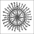
Compass Rose

A wind rose is a symbol in the shape of a circle that has marked around it the directions into which the circumference of the horizon is divided, and which would be north, south, east and west. Its invention is attributed to the Majorcan Ramon Llull, although the detailed description given by Pliny the Elder in the second book of his Natural History could have been the basic reference to it.
In navigational charts it is represented by thirty-two diamonds (deformed) joined at one end while the other indicates the course on the circle of the horizon. Above all is the fleur de lis with which the north is usually represented. That symbol is documented from the fifteenth century.
The North Atlantic Treaty Organization, known by its acronym NATO, has the wind rose as its main insignia.
The names of the winds

Traditional Greco-Latin names
| Wind | Direction | Greek | Latino | Franco | Spanish |
|---|---|---|---|---|---|
| N | 0° (30° × 0) | Aparctias (Aparctias)παρκταίας) | Northern | Nordroni | North, Tramontana |
| NNE | 30° (30° × 1) | Months (μ Miscellaneous), Boreas (βoρ) | Here. | Nordostroni | Bóreas, Aquilón |
| NEE | 60° (30° × 2) | Hunts (καικαας) | Caetia | Ostnordroni | Gregal, Cecias |
| E | 90° (30° × 3) | Apeliotes (Apeliotes)πλιετις) | Subsolanus | Ostroni | Solano, Levante |
| SEE | 120° (30° × 4) | Eurus (ειρος) | Vulturnus | Ostsundroni | Euro, Vulturno |
| SSE | 150° (30° × 5) | Euronotusερόοtος) | Euronotus | Sundostroni | Euronoto |
| S | 180° (30° × 6) | Notes (νόtος) | Auster | Sundroni | Noto, Austro |
| SSW | 210° (30° × 7) | Libonotes (λιβόνοtος) | Libonotus, Austroafricus | Sundvuestroni | Libyan, Libyan, Austro-African |
| SWW | 240° (30° × 8) | Lips (λίה) | Africus | Vuestsundroni | Abergo, Africa, Libis |
| W | 270° (30° × 9) | Zephyrusأعاج ماج ما ما ا ا ا ا ا ا ا ا ا ا ا ا ا ا ا ا ا ا ا لρος) | Favonius | Vuestroni | Céfiro, Favonio, Poniente |
| WNW | 300° (30° × 10) | Argestes (أعربي مع واك) | Caurus, Corus | Vuestnordroni | Coro, Argestes |
| NNW | 330° (30° × 11) | Thrasciasθρασκας) | Thrascias, Circius | Nordvuestroni | Close, Trascias |
The names of the Mediterranean winds

| cardinal point | Abrev. | Direction | Traditional Wind (name/s) | Abr.v |
|---|---|---|---|---|
| North | N | 0° | Tramontana, Terral, Etesio | T |
| Northeast, northeast | NE | 45° (45° × 1) | Gregario, Gregal, Greco, Bora | G |
| East | E | 90° (45° × 2) | Levante | L |
| Southeast, southeast, southeast | SEE | 135° (45° × 3) | Siroco, Chamsin, Marin, Fumeque, Calima, | S |
| South | S | 180° (45° × 4) | Ostro, Mediodía, Lodos | O |
| Southwest, Southwest | SO, SW | 225° (45° × 5) | Lebeche, Libeccio, Garbino | L |
| West | W | 270° (45° × 6) | Poniente, Vendaval | P |
| Northwest | NO, NW | 315° (45° × 7) | Master, Mistral, Galerna, Deer | M |
The cardinal points

The four cardinal points are:
- N - North
- S - South
- E - East
- O/W - West
To better identify these points, our body can be used as a reference. Orienting our front to the North, the south would be behind, the east would be to the right and the west to the left.
The four lateral directions

- N - North
- NE (North-East)-Northeast or Northeast
- E - East
- SE (South-East)-Southeast, southeast or south-east
- S - South
- SO/SW (South-West)-West or South-West
- O/W - West
- NO/NW (North-West)-North-West
The eight collateral paths

: N - North
- NNE (Northwest)
- NE (Norte-Este)-Noreste
- ENE (Eastern)
- E - East
- ESE (Estesudeste or Estesureste)
- SE (South-East)-South or Southeast
- SSE (Sursudeste or Sursureste)
- S - South
- SSO/SSW (South-West or South-West)
- SO/SW (South-West)-South-West
- OSO/WSW (West or West)
- O/W - West
- ONO/WNW (West)
- NO/NW (North-West)-North-West
- NNO/NNW (Northwest)
The sixteen co-collateral paths

Co-collateral bearings take their name from lateral bearings, adding "by" (abbreviation p) and in English "by" (abbreviation b) to indicate their relationship to the lateral strike from which they take their name. In the list below, the collateral courses are placed where it is not clear which courses they go between.
First quadrant
- 0 North, N
- 1 North by the Nord-East, NpNE
- 2 North Nord-East, NNE
- 3 North-East, NEpN
- 4 Nord-Este, NE
- 5 Nord-East by East, NEpE
- 6 This Nord-Este, ENE
- 7 East by the North East, EpNE
- 8 East, E
Second quadrant
- 8 East, E
- 7 East by the South-East, EpSE
- 6 East South-East, ESE
- 5 South-East by East, SEpE
- 4 South-East, SEE
- 3 South-East in the South, SEpS
- 2 South-East, SSE
- 1 South by the South-East, SpSE
- 0 South, S
Third quadrant
- 0 South, S
- 1 South by the South-West, SpSO
- 2 South-West, SSO
- 3 South-West by the South, SOpS
- 4 South-West, SO
- 5 South-West by West, SOpO
- 6 South-West West, OSO
- 7 West by South-West, OpSO
- 8 West, O
Fourth quadrant
- 8 West, O
- 7 West by the Northwest, Option
- 6 North-West West, OTHER
- 5 Northwest by the West, NOPPE
- 4 North-West, NO
- 3 North-West, NOPPN
- 2 North-West, NON
- 1 North by the North-West, NpNO
- 0 North, N
The thirty-two directions
The 32 directions of the wind rose are:
- North, South, East, West.
- Northeast, Southeast, Southwest, Northwest.
- North-west, East-West, East-West, South-East, South-West, West, West-west, North-West.
- North by the East, Northwest by the North, Northeast by the East, East by the North, East by the South, Southeast by the East, South by the South, South by the East, South by the West, Southwest by the South, Southwest by the West, West by the South, West by North, Northwest by West, Northwest by North and North by West.
The Course
A course is determined by the cardinal points of the wind rose, each of which has an established numerical value or angle based on the following criteria:
1. The most classic form is the one that divides the circumference into four quadrants and each one of these quadrants in 90 degrees, the zero value corresponding to both north and south, or indicating eight directions in each of these quadrants.
 | |

2. The NORTH direction is the angle 0° or 360°.
3. In the clockwise direction, an angle is formed by taking N as reference and it varies from 0° to 360°.

4. Clockwise, an angle is formed taking N as reference and reaching S, it varies from 0° to 180°.
5. In an anticlockwise direction, an angle is formed taking N as reference and reaching S, it varies from 0° to 180°.

6. In a clockwise direction, the wind rose is divided into 6400 parts, this course is called an indication in angular thousandths or artillery thousandths starting from the N reference as 0°. The division of the circumference in 6400 thousandths means that all the cardinal points are an exact multiple of this angular unit, see the figure.
Sectors (in sexagesimal degrees) corresponding to each wind
- North Wind or Tramontana (N): from 337.5° to 22.5°
- Wind from the northeast or Gregal (NE): from 22.5 to 67.6°
- East Wind or Levant (E): from 67.5° to 112.5°
- Southeast or Siroco Wind (SE): 112.5° to 157.5°
- South Wind or Ostro (S): from 157.5° to 202.5°
- Southwest Wind: Lebeche or Garbino (SW): from 202.5° to 247.5°
- West or West Wind (W): 247,5° to 292,5°
- Northwest Wind: Mistral (NW): from 292.5° to 337.5°
Stellæ maris (The Stars of the Sea)
| cardinal point | Star | Constellation |
|---|---|---|
| N | Polar | Alpha ursæ minoris |
| NpE/NbE | "Osa Guards" (Dubhe and Merak) | Alpha and Beta ursæ maioris |
| NNE | Dubhe | Alpha ursæ maioris |
| NEpN/NEbN | Schedar | Alpha Casiopea |
| NE | Capella | Alpha aurigæ |
| NEpE/NEbE | Vega | Alpha lyrae |
| ENE | Arturo | Alpha bootis |
| EpN/EbN | The Pleiades | Taurus |
| E | Altair | Alpha aquilae |
| EpS/EbS | Orion Belt (Alnitak, Alnilam and Mintaka) | Delta, Epsilon and Zeta orionis |
| ESE | Sirio | Alpha Canis Majoris |
| SEpE/SEbE | Acrab | Beta scorpii |
| SEE | Antares | Alpha scorpii |
| SEpS/SEbS | Rigil Kent(aurus) | Alpha centauri |
| SSE | Canopo | Alpha carinæ |
| SpE/SbE | Achenar | Alpha eridani |
| S | South Cross |
The Arabian navigators of the Red Sea and Indian Ocean relied more on celestial navigation, rather than the winds, and used the 32-point rose before the end of the 10th century.
The orientations were based on the rising and setting positions of a series of bright stars and even asterisms such as the Pleiades, Orion's belt or the Southern Cross.
In the northern hemisphere, the presence of the Polaris star was used to calculate the N-S meridian axis; however, the changing position of the Southern Cross is what you get for the southern hemisphere, as the southern pole star is Sigma Octantis which is too faint to be easily seen with the naked eye. The other thirty sidereal points are determined by the rising and setting of the position of fifteen bright stars in the northern hemisphere. Reading from North to South, in both their sunrise and sunset positions, this is how it looks in the attached table.
Use of the compass rose in airport design
A wind analysis is carried out with statistical data of wind intensity and direction at the location, measured over a period of at least five years and at least eight times a day with equal intervals. If it is not possible to carry out measurements at the site itself, statistics from nearby places where there is an observatory may be used, taking into account that there may be differences between the respective environmental conditions.
These observations are grouped into speed intensity intervals, measured in knots, and for the directions each quadrant (N, S, W, E) is divided into four sectors, so that there are sixteen sectors of wind direction (number of observations and frequencies).
The graphic representation of these wind intensity and direction data is made by taking them to a diagram of concentric circles, whose radii are to the scale of the frequencies of the observations in each direction. This diagram is known as a wind rose.
Annex: Angular tabulation of the cardinal points by quadrants
The circumference of the wind rose is measured angularly in a clockwise direction starting from the zenith (12 o'clock) where the point N (north) is located.
- The first quadrant is the right upper quadrant of the circumference and connects points N and E (this)(3 hours).
- The second quadrant is the right lower quadrant of the circumference and connects points E and S (sur) or nadir (6 hours).
- The third quadrant is the left lower quadrant of the circumference and connects the points S and W (west) (9 hours).
- The fourth quadrant is the upper left quadrant of the circumference and connects the points W and N or cénit (12 hours).
The angle measurement systems tabulated here are the following:
1. Sexagesimal system: Which gives a value of 360° (degrees) to the circumference, 60" (seconds) are 1' (minute) and 60' They are 1st (grade).
2. Centesimal system: Which gives a value of 400g (gonios) to the circumference, 100cc (hundredth seconds) are 1c (hundredth minute) and 60c are 1g (gonio).
3. Thousand Gunner System: Which gives a value of 6400‰ (per thousand) to the complete circumference, 1‰ equals 2' 48.75" and 6c 25cc, so submultiples are not used.
FIRST QUADRANT N-E
| Sexagesimal angle | Centesimal angle | Artillery angle | Abbreviation | cardinal point |
|---|---|---|---|---|
| 0o | 0g | 01,000 | N | North |
| 11o25' | 12g50c | 200 per thousand | NpE | North by East |
| 22o50' | 25g | 400 per thousand | NNE | Northwest |
| 33o75' | 37g50c | 600 per cent | NEpN | Northeast by North |
| 45o | 50g | 800 per | NE | Northeast |
| 56o25' | 62g50c | 1000 | NEpE | Northeast by East |
| 67o50' | 75g | 1200 per | ENE | East |
| 78o75' | 87g50c | 1400 per 1,000 | EpN | East by North |
| 90th | 100g | 1600 per 1,000 | E | East |
SECOND QUADRANT E-S
| Sexagesimal angle | Centesimal angle | Artillery angle | Abbreviation | cardinal point |
|---|---|---|---|---|
| 90th | 100g | 1600 per 1,000 | E | East |
| 101°25' | 112g50c | 1800 per | EpS | East by South |
| 112°50' | 125g | 2000 per thousand | ESE | Eastsure. |
| 123°75' | 137g50c | 2200 per 1,000 | SEpE | Southeast by East |
| 135° | 150g | 2400 per 1,000 | SEE | Southeast |
| 146°25' | 162g50c | 2600 per 1,000 | SEpS | Southeast by South |
| 157°50' | 175g0c | 2800 per 1,000 | SSE | Sursureste |
| 168°75' | 187g50c | 3000. | Sp | South by East |
| 180o | 200g | 3200 per | S | South |
THIRD S-W QUADRANT
| Sexagesimal angle | Centesimal angle | Artillery angle | Abrev.internacional | cardinal point |
|---|---|---|---|---|
| 180o | 200g | 3200 per | S | South |
| 191o25' | 212g50c | 3400 per 1,000 | Sp | South by West |
| 202o50' | 225g | 3600 per | SSO | Southwest |
| 213o75' | 237g50c | 3800 per | SOpS | Southwest by South |
| 225o | 250g | 4000 per | SO | Southwest |
| 236o25' | 262g50c | 4200 per | SOpO | Southwest by West |
| 247° 50' | 275g0c | 4400 per 1,000 | OSO | West |
| 258° 75' | 287g50c | 4600 per 1,000 | OpS | West by South |
| 270° | 300g | 4800 per | O | West |
FOURTH QUADRANT O-N
| Sexagesimal angle | Centesimal angle | Artillery angle | Abrev.internacional | cardinal point |
|---|---|---|---|---|
| 270° | 300g | 4800 per | O | West |
| 281° 25' | 312g50c | 5,000. | OpN | West by North |
| 292° 50' | 325g | 5200 per 1,000 | OTHER | Westwest |
| 303° 75' | 337g50c | 5400 per 1,000 | NOPPE | Northwest by West |
| 315o | 350g | 5600 per 1,000 | NO | Northwest |
| 326o25' | 362g50c | 5800 per 1,000 | NOPPN | Northwest by North |
| 337o50' | 375g0c | 6,000 | NON | Northwest |
| 348o75' | 387g50c | 6200 per | NpO | North by West |
| 360° | 400g | 6400 per 1,000 | N | North |
Gallery

Rose of the winds of 16 points

Rose of the 32-point winds with abbreviations of direction in Spanish associated with and equivalent degrees from the north. The bezel presents graduation marks in 1 degree increments.

Rose of the international winds of 4 points

Rose of the international winds of 8 points

Rose of the international winds of 16 points

Rose of the winds of an old navigation letter, by the Portuguese cartographer Pedro Reinel (1504)
A rose of historical winds
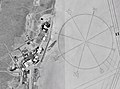
The rose of the world's largest winds, drawn on the desert floor at the Edwards Air Force Base in the USA. U.S.

Rose of the Spanish Winds of Catalonia


Contenido relacionado
Sahara desert
James I of Aragon
First generation of computers