Colima
Colima (![]() listen)officially Free and Sovereign State of Colima, is one of the thirty-one states that, together with Mexico City, form Mexico. Its capital is the homonymous city and the most populous city is Manzanillo. It is divided territorially into ten municipalities.
listen)officially Free and Sovereign State of Colima, is one of the thirty-one states that, together with Mexico City, form Mexico. Its capital is the homonymous city and the most populous city is Manzanillo. It is divided territorially into ten municipalities.
It is located in the western region of the country, bordering Jalisco to the north, Michoacán to the south, and the Pacific Ocean to the west. With 731,391 inhabitants in 2020, it is the least populated state, with 5,627 km², the fourth least extensive —ahead of Aguascalientes, Morelos and Tlaxcala, the least extensive— and with 115.65 inhab / km², the ninth most densely populated, behind of the State of Mexico, Morelos, Tlaxcala, Aguascalientes, Guanajuato, Puebla, Querétaro and Hidalgo.
It was founded on December 9, 1856.
Apart from its capital and its most populated city, other important towns are Manzanillo, Tecomán, Armería, Comala, Villa de Álvarez, Cuauhtémoc, Ixtlahuacán, Coquimatlán and Minatitlán.
Toponymy
Colima is derived from the Nahuatl "Acollima" or "Acolliman", composed of "atl" (water), "colic" (crooked or bent) and the locative ending "-man", translated as "(the) place where the waters bend" or "(place in) the bend of the river".
Description
Originally founded in 1523 as Villa de San Sebastián, Colima's name comes from the Nahuatl Acolman, meaning "place where the water twists" or "place where the river bends". The territory of Colima, of which almost three quarters of the surface is covered by mountains and hills, is included within a derivation of the Sierra Madre del Sur, which is made up of four mountain systems.
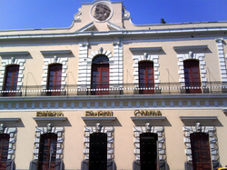
Despite being a small entity, Colima has historical monuments such as its minor basilica cathedral, construction that began in 1525 in a predominantly neoclassical style although it also shows some architectural features of baroque and gothic styles; the Government Palace, with the magnificent murals by the Colima painter Jorge Chávez Carrillo, which illustrate historical themes related to the Conquest, Colonization and the War of Independence. Other cultural and architectural places that stand out are: The Hidalgo Theater, which dates from the XIX century; the Temple of San Francisco del Pilón, founded in 1554; the House of Culture, with an incredible library, exhibition hall, auditorium and workshops for various artistic activities.
The coastal state of Colima continues its limits in the ocean, to the Revillagigedo Islands; ecological reserves, populated only by seabirds and by members of the army that guard this border of the country. The urban areas of the city of Colima and the city of Villa de Álvarez have engulfed sites that until very late in the XX century were located on the outskirts of that urban sprawl, such as San Francisco de Almoloyan or the archaeological sites of La Campana and El Chanal.
History
During the pre-Hispanic era, the region now occupied by the state of Colima was the seat of various ethnic groups that flourished in Western Mexico. The region was inhabited by several lordships that disputed the territory before the arrival of the Spanish conquerors. At the beginning of the XVI century, the Purépecha came to dominate even the nitrate mines of Tzacoalco, property of the Tecos, because of this King Colimán or Tlatoani Colimotl made war on them and on many occasions defeated them, after the Saltpeter War with which the Tecos took Sayula, Zapotlán and Amula and even managed to take their domain to Mazamitla, achieving that the lordship of Colima was became the dominant group.
After the Europeans reached an agreement with the Purépechas, an emissary of Hernán Cortés, named Francisco Montaño, one of the first to venture to the capital of the Purépecha empire, Tzintzuntzan, picked up and introduced his above information that said that to the west of the Señorío del Caltzontzin there was a place dominated by King Colimotl. Hernán Cortés thought of conquering Colima, but Juan Rodríguez de Villafuerte precipitated his plans by disobeying his orders and being the first to explore the area. Upon his arrival in Trojes, he was defeated in an ambush by King Colimán. Shortly after, Cortés decided to entrust the company to Francisco Álvarez Chico. He left with a small army along the road to Toluca, towards the coast of the Purépecha manor, today Michoacán.
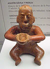
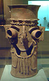
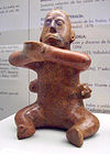
| Craft colimense. Trophy head. | Craft colimense. Incensor Tláloc. | Colima style figure with trophy heads. |
When crossing with his people through a small gorge, King Colimotl's warriors attacked by surprise. Francisco Álvarez Chico along with other soldiers were defeated at the Alima Pass and/or Palenque de Tecomán. After this defeat, a new expedition was organized, called punitive, which was entrusted to Cristóbal de Olid, who in 1522 had been sent to finish conquering the Purépecha Señorío in the name of Hernán Cortés, but failed to reach the land of King Colimotl.. Cortés entrusted the next expedition to Gonzalo de Sandoval, who finally defeated the Tecos or Colimecas at Palenque de Tecomán, where King Colimán surrendered.
After the conquest of Mexico was consummated, Gonzalo de Sandoval himself founded in Caxitlán the Villa de Colima in terms of Tecomán, on July 25, 1523, but due to unsanitary problems he had to move the settlement to the place it occupies today, naming it Villa de San Sebastián. In 1533 Hernando de Grijalva set sail from the region's coasts to discover the Revillagigedo Archipelago.
The Order of Mercy, also known as Los Mercedarios, founded in 1607 a full-blown convent in what was then Villa de San Sebastián, but unfortunately the ruins that testified to such an important educational institution in Colima have not survived. During the Viceregal era, the Port of Tzalahua (Manzanillo) stood out as an important defense and trade site for New Spain. During the independence movement, the capital was taken by the insurgents at the end of 1810 without encountering royalist resistance and was recovered by the viceroyalty's army in 1811. Finally, in 1857 Colima reached state status.
November 5, 1864 is the date that was inscribed in the history of Colima, as it was incorporated into the list of cities during the Second French Intervention in Mexico.
Benito Juárez was exiled in the distant territories of the north of the country, while Colonel Julio García was Governor of the State, the Doway Brigade entered the city, granting protection and administrative protection, remaining the state of Colima politically and administratively incorporated into the government headed by Maximilian I.
Political division
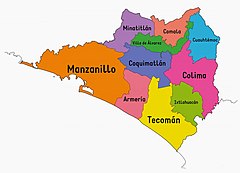
The State of Colima is politically divided into 10 municipalities. The municipalities have their own government that resides in the City Council, which is directed by a Municipal President elected by popular election.
The municipalities of the State of Colima:
- Armory
- Colima
- Comala
- Coquimatlán
- Cuauhtémoc
- Ixtlahuacán
- Manzanillo
- Minatitlán
- Tecomán
- Villa de Álvarez
Limits
| Northwest: Jalisco Mexico | North: Jalisco Mexico | Northeast: Jalisco Mexico |
| West: Jalisco Mexico |  | This: Jalisco, Michoacán Mexico |
| Southwest: Pacific Ocean | South: Pacific Ocean | Sureste: Michoacán Mexico |
Physical Geography
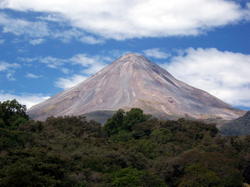
Colima has a large volcano, the Volcán de Fuego, located on the border between the Mexican states of Colima and Jalisco but with greater visibility towards Colima. Together with the Nevado de Colima (which rises to the north of the volcano), it forms part of the protected natural area that bears the name of the latter. Despite its persistent activity, agricultural work has continued to develop in the neighboring region.
The mountainous reliefs cover the west, the north and the eastern part of the entity. The penetrations of the Jalisco mountains form the highest areas: Cerro Gordo, Sierras de Perote, El Peón and the foothills of the Colima volcano. The Piscila mountain range borders the wide Colima valley to the south; to the south, the Tecomán plains end in a low, sandy coastline. The entity has two extensive bays: Manzanillo and Santiago, as well as the Revillagigedo archipelago.
The main rivers of Colima originate in Jalisco. The Armería and its tributaries, the Comala and the Colima, irrigate its central part; the Cihuatlán or Marabasco to the west and the Coahuayana, with its tributary the Salado, irrigates the eastern part. The lagoons of Potrero Grande, Miramar, San Pedrito, Alcuzahue, Amela and Cuyutlán, rich in salt deposits, are located in the coastal zone. It has a warm sub-humid climate, except for the sierras, where it is semi-warm sub-humid, and the plains of Tecomán, where it is warm, semi-dry.
Climate
The climate of Colima can be very varied, although humidity predominates. In the north of the State the climate is warm sub-humid, while in the mountains there is a semi-warm sub-humid climate and the plains of Tecomán have a warm semi-dry climate. In the coastal area and in the Armería river basin the climate is hot and humid. The average annual temperature in the State is 28 °C and oscillates between a maximum of 38 °C and a minimum of 12 °C. One of the greatest attractions of Colima is the benignity of its climate. The small geography of the State allows you to enjoy, in a journey of an hour and a half, the temperate climate of the mountains or the tropical heat of its beaches for a choice of climates. The average annual temperature oscillates around 25 °C, with a maximum of 38 °C and a minimum of 7 °C. The average annual rainfall is 983 millimeters. Colima's climate is greatly influenced by its mountainous relief, which covers the west, north, and east of the state. The penetrations of the Jalisco mountains form the highest areas: Cerro Gordo, Sierras de Perote, El Peón and the foothills of the Colima volcano. The Picila mountain range borders the wide Colima valley to the south, and to the south, the Tecomán plains end in a low, sandy coastline. These sierras, due to their latitude and exposure, allow for greater rainfall and for the climate to be different in relation to the lower parts of the state. In the coastal zone and in the Armería river basin the climate is hot and humid, while in the upper part it is temperate and warm in the southern zone. Its average annual temperature is 28 °C and oscillates between a maximum of 38 °C and a minimum of 12 °C .
Flora
There are various species of flora, depending on the region in question: in the upper parts pine, oak, oak, and myrtle predominate; in the valleys there are forage and fruit species such as mango, papaya, tamarind, coconut palm; while the coast has guamúchil, guayacán, mesquite, chicalite, crucillo and mangrove. Of the latter we can find two kinds: the white mangrove and the red mangrove. Both play a very important role in preserving the balance in the ecosystems that refer to the estuary, which is where the sea meets fresh water, in addition to being an irreplaceable natural barrier against possible tsunamis, hurricanes and floods.
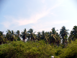
On the other hand, coconut palms (or palm trees, as they are commonly known in this state) are par excellence one of the main symbols of Colima and can be found practically throughout the state.
Wildlife
Due to its diversity of ecosystems, in the State of Colima there is an extensive variety of wildlife: squirrel, collared wild boar, white-tailed deer, ocelot, tigrillo, fox in the mountains; while in the valleys there are species such as tapacaminos, dove, zanate, opossum, tzentzontle, rabbit and coyote. Regarding the marine fauna, this is made up of goldfish, sharks, horned fish, stingers, hawksbill turtles, among others.
Orography and hydrography
In the State of Colima there are various orographic elements: from mountains, ravines, valleys, plains, plateaus, among others, they are part of the two physiographic provinces that include the State, that of the Neovolcanic Axis and that of the Sierra Madre del Sur. The Colima and Cerro Grande volcanoes are located in the Northeast and North portion of the entity respectively, the latter is the southern continuation of the Sierra de Manantlán in the neighboring State of Jalisco. These different monostructures determine the conditions and influence the behavior of the climate and regional hydrology. The precipitation and evapotranspiration values are directly related to the predominant climate, which is warm sub-humid and very warm semi-dry, where the average annual temperature varies from 24.8 to 26.6 °C, with rains in summer, ranging between the months warmest and coldest is less than 5 °C; also due to the composition of the soil whose dominance is the low permeability of the most exposed materials, such as andesite, intermediate tuff, intermediate volcanic breccia, conglomerate, sandstone, limestone and alluvial soil of variable granulometry.
The State is included within hydrological regions 15 and 16, called the Jalisco coast and Armería-Coahuayana, respectively. Most of the water resources that affect these regions are caused by high levels of infiltration and runoff that come from the high mountain areas in southern Jalisco. The behavior of the hydrological regime transcends the entity, since most of the rivers are currents that support economic activities.
Volcanoes of Colima
The Colima Volcano or Fuego Volcano rises to 3860 m a.s.l. no. m., is one of the symbols of Colima. This volcano is shared by the states of Jalisco and Colima. The municipalities affected by the activity of the volcano are Comala and Cuauhtémoc, in Colima, and Tuxpan, Zapotitlán and Tonila in Jalisco. The type of volcano is a stratovolcano; its eruptions have been considered explosive. Throughout 500 years the volcano has had more than 40 explosions since 1576, of which those of 1585, 1606, 1622, 1690, 1818, 1890, 1903 stand out, the most violent being that of 1913 and the most recent in February of 1999 and that of June 6, 2005 at 11:00 a.m. (local time), there was an eruptive column that reached over the volcano, spewing rock ash and pyroclastics. Both events are the ones with the highest energy released after the event of January 13, 1913, which closed the fourth cycle of activity. The volcano is a neighbor of Nevado de Colima, the highest point in the western sector of the Mexican Volcanic Belt. An ancient volcanic massif located in the state of Jalisco, in the west of the Mexican Republic; in the vicinity between the states of Jalisco and Colima. It is a great panorama to see the two volcanoes together and even more so when the Nevado de Colima is dressed in snow and the Volcán de Fuego greets us with a fumarole. The state also has 2 other volcanoes, which are located in the Revillagigedo archipelago, the Evermann volcano and the Bárcena volcano on Socorro Island.
Demographics
Population
According to the figures provided by the 2020 Population and Housing Census carried out by the National Institute of Statistics and Geography (INEGI) in 2020, the state of Colima had until then a total of 731,391 inhabitants, of said number, 360,622 were men and 370,769 were women. The annual growth rate for the entity during the period 2010-2020 was 12.4%.
Main Cities (2020)
The graph shows the 10 cities with the largest population counting only the city, without including Conurbated Areas, Municipality or Metropolitan Area.
Most populated municipalities (2020)
The following shows the 10 municipalities of Colima by number of inhabitants according to the XIV Population and Housing Census 2020.
| Municipality | Population |
|---|---|
| Manzanillo | 191 031 |
| Colima | 157 048 |
| Villa de Álvarez | 149 762 |
| Tecomán | 116 305 |
| Cuauhtémoc | 31 267 |
| Armory | 27 626 |
| Comala | 21 661 |
| Coquimatlán | 20 837 |
| Minatitlán | 10 231 |
| Ixtlahuacán | 5 623 |
Communications and transportation
Colima has a network of highways and roads, among which are the axes that connect cities such as Colima-Guadalajara, Tecomán-Lázaro Cárdenas, Manzanillo-Barra de Navidad-Puerto Vallarta, and Colima-Morelia, as well internal roads such as Colima-Manzanillo, Colima-Armería, and Colima-Tecomán. As for air communication, there are two airports in the state of Colima, the Playa de Oro International Airport in Manzanillo and the Miguel de la Madrid National Airport in Buena Vista, Cuauhtémoc.
The state of Colima also has the port of Manzanillo, Mexico's most important port on the Pacific. Manzanillo was the third port that the Spanish created in the Pacific and in the development of its history there are very important facts and characters.
The vehicle capacity is 1000 daily trucks to the Port, 850 light vehicles and 900 daily motorcycles on average. More than 26 shipping lines call the port on a regular route, and it also operates more than 90% of the containerized cargo that is handled through the Mexican Pacific.
On July 6, 2010, the Ministry of Communications and Transportation inaugurated the dock specialized in tourist cruises in the port of Manzanillo, which involved an investment of 100 million pesos in the first stage. The work has the capacity to serve two cruise ships simultaneously and in a second phase the construction of a shopping center is planned, according to the authorities. The Queen Elizabeth is scheduled to arrive. on Friday, February 1, 2013 sister ship of Queen Victoria
In the field of urban transport, in the Colima-Villa de Álvarez Conurbation Area in the State of Colima there are two companies that manage urban transport; which are SINTRA (Sistema Integral de Transporte S.A. de C.V.) and SOCACOVA (Sociedad Cooperativa de Autotransportes Colima-Villa de Álvarez S.C.L.); which had a vehicle park of a total of 227 units of which 50% of units are working in each company.
Culture
Officially called colimenses. Other demonyms are mentioned, for example, colimote(a), colimeño(a). A legend from Colima describes him as someone calm, relaxed, hospitable, happy. Sitting under the peaceful shade of a palm tree in one of the city's many squares, he cools off sipping from a cold tuba . Around it, picturesque houses adorn the streets and numerous coconut palm trees sway to the beat of the sweet wind with the smell of salt. One of the great pleasures of the people of Colima is cooking. Due to which numerous typical dishes adorn their tables, prepared mainly with corn, fruits, pork, fish and shellfish.
Several varieties of corn tamales, sopes covered with hash, leg, tenderloin or chicken; river prawns prepared in broth, moyos or devilishly stewed Moorish crab, pork pozole and pork meat tatemado delight the palates of locals and visitors. In addition, the ceviche from Colima and the fish a la talla are distinguished for their originality. Also, sweet fruit desserts such as pineapple alfajor, cocada, guava rolls, dehydrated bananas and tamarind sweets stand out for their rich flavor. To cool off, all you have to do is look for a “tubero”, a typically Colima character who does not hesitate to climb a palm tree to come down with what will be the nectar that will suffocate any heat, the tuba.
And, although it originates from the Philippines, in Mexico the tubero is from Colima. A profession passed down from generation to generation, the tubero obtains the nectar from the spikes of the coconut palm flowers to prepare a refreshing and delicious drink that, together with the tejuino and the bat, are part of the Colima tradition of natural drinks. The “mariachi de arpa”, which replaces the traditional trumpet with a harp), is the typical musical expression of the Colimeños. To the beat of the most traditional sones and syrups, happy dancers and devotees celebrate one of the many Catholic patron saint festivities of each community. The most representative sones of the state are El Camino Real de Colima, Las Comaltecas, El Perico Loro, El Palmero, El Pasacalles, La Iguana de Tecomán, El Pedregal, El Pitayero and Los Morismas. Otate, reed and vulture weaves make beautiful handicrafts of great artistic value. Suchitlán artisans produce all kinds of baskets and baskets that have given the region international fame.
Gastronomy
Among the most liked and representative dishes from Colima in the state are sopitos -small toasts covered with mincemeat and bathed in "juice"-; fat sopes, leg, pork loin or chicken; and the toasts of the same meats and prepared on shaved and golden tortillas. Pozole (cooked corn) with pork is the traditional snack, with the characteristic of being dry and juicy. These dishes can be tasted in the famous diners that exist throughout the city. Other typical stews are tatemado -pork meat macerated in coconut vinegar and stewed in red chili-, pepena -stewed beef entrails-; and cuachala -maize maize and cooked with shredded chicken-. Local varieties of tamale are pata de mula -bean, wrapped in "leaf" of corn, not in totomoxtle-; those of meat and those of tender corn, as well as those of ash. Comala is distinguished by the production of dairy products, such as quesillo ranchero, panela and cream, as well as the popular alcoholic beverage punches, prepared by mixing cane brandy or liquor with water, sugar, coffee, peanuts and other fruits, especially the punch of Granada, the most popular combination, is also distinguished by its cheerful botaneros, places to spend some time with the family; also, together with Villa de Álvarez, for its sweet bread, of which the bonnets or picón de huevo stand out.
The traditional drinks in hot weather are the tuba, the bat and the tejuino. During the rainy season it is possible to enjoy the jackals, or river prawns, prepared in broth. Also at that time, on the coast, the moyos - variety of Moorish crab -, stewed to the devil. There are shrimp farms that ensure a permanent supply of this culinary delight, which can be enjoyed in broths, with butter, with garlic or simply cooked. Different from the way it is prepared in neighboring states, Colima ceviche is made by finely shredding the fish (preferably sawfish) and cooking it in Tecomán lemon juice and mixing carrots, onion, cilantro, and tomato; In addition, ceviche can be made with shrimp. Pescado a la talla is a highly appreciated specialty. It is prepared with a whole fish, opened and covered with chopped vegetables, then wrapped in banana leaves and grilled.
Crafts
In Colima, magic and imagination have been transformed into a rich and varied craft, which combines daily use with artistic talent. The artisans have used different materials in the elaboration of their crafts, such as wood, metal, ceramics and pottery; vegetable fibers, textiles, saddlery, shelling; all this worked in their different techniques. The best craftsmanship in the state is the manufacture of beautiful red cedar furniture, with Spanish reminiscences and decorated in oil. Armchairs with cowhide seats are made and very original ceremonial masks are carved, adorned with long hair and beards. Another area where craftsmanship stands out is in textile clothing, within which we find commercial fabric confections: dresses, embroidered blouses, as well as the regional costume of white blanket with the image of the Virgin of Guadalupe, embroidered in brown on the huipil. There is also a lot of hook work, such as folders, blouses, tablecloths and other items of daily use. In the pottery work, porous clay is used to make copies of pre-Hispanic pieces from western Mesoamerica; among them stand out large human figures and pipes. Finally, Colima has the craft of basketry, which is one of the most important crafts, which also makes up one of the pre-Hispanic legacies that have survived until now.
Among the most popular crafts and in greatest demand for being representative of the State are the famous Colima dancing dogs, typically made of red clay, but they can also be found in parota wood, an emblematic tree of the State.
Featured Characters
- Luis Felipe Núñez Palomino
- Alejandro Rangel Hidalgo (Pintor)
- Alfonso Michel (Pintor)
- Anastacio Brizuela (Militar)
- Balbino Dávalos (Poet)
- Basil Vadillo (Polithic)
- Benjamin Fuentes González (Educador)
- Enrique O. From Madrid (Governor)
- Felipe Sevilla del Río (Escriber, historian and poet)
- Ferdinando Valencia (Actor)
- Philomeno Bravo (Polithic and Military)
- Gregorio Torres Quintero (Benemérito de Colima)
- Griselda Álvarez Ponce de León (First Governor in Mexico)
- Jaime Gómez (Futbolist)
- César Valdovinos (Futbolist)
- Jesús González Lugo (Master and Military)
- Jesús Robles Martínez (Polithic)
- Jorge Chávez Carrillo (Pintor)
- José Calixto Martínez y Moreno (Militar)
- Juan José Ríos (Militar and Political)
- Manuel Alvarez (Polithic)
- Mario Anguiano Moreno (Polithic)
- Miguel de la Madrid (President of Mexico)
- Miguel Galindo Velasco (Medical and historian)
- Rafaela Suárez Solórzano (Educadora)
- Ramon R. De la Vega (Benemérito de Colima)
- Ricardo Guzmán Nava (Educator and politician)
- Silverio Palacios (Actor)
- Vicente Alonso (Bad and revolutionary)
- Patricio Araujo (Futbolist, World Champion Sub 17, 2005)
- Fernando Moreno Peña (Polithic)
- Gustavo Alberto Vázquez Montes (Professor and politician)
- Rogelio Guedea (writer, poet, essayist and translator)
Universities in Colima
- University of Colima
- For more information from the University of Colima, see article: University of Colima
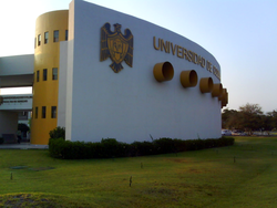
At the University of Colima, the Faculties of Law and Accounting were the first in the initial stage of their autonomy and with them, the university deployment also began, thereby giving State students the opportunity to fulfill themselves as professionals of the laws, coupled with the fact that the Law career offers more job opportunities every day both within the Attorney General and in the judicial career. It is also important to highlight that the School of Law is not only the oldest but also to this day is the most prestigious of all because lawyers have graduated from it and have elevated said federative entity; to mention one, the Minister of the Supreme Court of Justice of the Nation, José Ramón Cosío Díaz, an outstanding graduate of the Faculty of Law. The University of Colima was born as the Popular University of Colima on September 16, 1940, with a project inspired by the revolutionary spirit. On August 25, 1962, it was granted autonomy and separated from the state educational system, establishing strong university careers in the administrative and agricultural areas, and beginning hard work to obtain sufficient resources for its growth.
- Pacific Autonomous University
- Vizcaya University of the Americas Colima Campus and Manzanillo
- Universidad del Valle de Atemajac Campus Colima
- Instituto Colimense de Estudios Superiores
- Instituto Tecnológico de Colima
- Univer Colima University
- Instituto Tecnológico de Estudios Superiores de Monterrey Sede Colima
- Instituto Autónomo de Estudios de Tecomán
- Technological University of Manzanillo
- Instituto Superior de Educación Normal de Colima
Archaeological sites
- The Chanal
- La Campana
- Meseta de la Hierbabuena
Historical monuments
- San Francisco de Almoloyán.- It is located in the city of Colima. Ruins of the Old Franciscan Convent of the CenturyXVI.
- Comala (6 km north of the Cd. de Colima).- Also called The White People of America, Comala preserves the typical architecture of the region of the volcano, as well as it is the magical village
- Month of Caxitlán.- It's on the Colima-Tecomán road.- Ruins of an ancient Month of the Real Road (S. XVIII), built on the grounds of the ancient indigenous village of Caxitlán, where in 1523 the first village of Colima was founded.
- Palacio de Gobierno - It is located in the Jardin Libertad de la Cd. de Colima; it is a century buildingXIX. In its main staircase there is a mural by the painter colimense Jorge Chávez Carrillo.
- Federal Palace.- It is located in the Núñez de la Cd. de Colima. Civil architecture from the beginning of the centuryXX.. On the upper floor are preserved murals with representation of landscapes of Mexico City and portraits of historical characters.
- Hacienda de Nogueras.- It belongs to the municipality of Comala, it is a restored trapiche hacienda. You can visit the chapel (S. XVII), the main house (S. XIX) and the museum.
- Mercado Enrique O. de la Madrid.- Located in the center of the Cd. de Colima, the building is an example of prefabricated metallic architecture -francesa-, of the porfirian period. It is currently a cultural centre.
- Hidalgo Theatre, located in the center of the Cd. de Colima.- Porfirian building, an example of horseshoe theatre. Work of the Alarife Lucio Uribe.
- Municipal Historical Archive of Colima.- It's in the middle of the Colima Cd. It is an example of the typical humming house of the centuryXIX.
- Historical Archive of the State.- (Jardín Juárez or La Concordia, Cd. de Colima).- Example of porferian civil architecture from the beginning of the centuryXX.. Old School of Applied Arts.
- Old Railway Station.- It is located south of the Hidalgo Park of the city of Colima. It is an example of the late-century railway architectureXIX.
- Hacienda del Carmen.- It belongs to the municipality of Villa de Álvarez, it is a cattle ranch of the centuryXIXrestored.
- Hacienda de San Antonio.- It is located in the municipality of Comala. Coffee farm of the centuryXIX restored. With chapel and stone aqueduct.
Sports
- Loros de la Universidad de Colima - Football
- Soccer Manzanillo Club
- BM Colima - Balonmano
Sister States
The state has signed the following twinning agreements:
Contenido relacionado
Egypt
Malt
Ensanche District
