
Ciudad Real Province
Ciudad Real is a Spanish province in the autonomous community of Castilla-La Mancha, with its capital in the city of Ciudad Real. It has a population of 492,591 inhabitants (INE 2021), spread over 102 municipalities. In the northwest rise the mountains of Toledo, while to the south, on the border with Andalusia, rises the Sierra Morena. The central and eastern part of the province, crossed by the Guadiana river, is occupied by the Manchego plain.
Geography
Its landscape is defined by the Central Plateau, in its southern half; It is a flat profile with small hills, normally of low altitude. To the south, the province is delimited by Sierra Morena, whose main pass towards the autonomous community of Andalusia is in Despeñaperros. The north is delimited by the mountains of Toledo, of low altitude.
With an extension of 19,813 km² (third largest in Spain after Badajoz and Cáceres), it limits to the north with Toledo, to the northeast with Cuenca, to the east with Albacete, to the south with Jaén and Córdoba and to the west with Badajoz. It has an exclave, the municipality of Anchuras, in the northwest of the province.

The main hydrographic basin is the Guadiana. This river has its source in the Ruidera lagoons, to the east of the province, which disappears and reappears near the town of Villarrubia de los Ojos. Some of its tributaries in the province are the Cigüela, Záncara, Azuer, Jabalón and Bullaque rivers.
The province's climate is continental Mediterranean, with one of the largest temperature fluctuations in the Iberian Peninsula. This causes cold winters and very hot and dry summers.
The limits of the province of Ciudad Real are practically those of the old province of La Mancha, whose capital was Ciudad Real and from which the Montes de Toledo were excluded.

Country
The province can be divided into regions and subregions. The old region of La Mancha Ciudad Real included the sub-regions of: Campo de Calatrava (of the homonymous Order), in the center; to the southwest, the Valley of Alcudia; and to the east, the Campo de Montiel. Other regions were: to the northwest, the Montes de Toledo; in the southeast, Sierra Morena; and to the northeast, the region of Campo de San Juan, because it belonged to the Order of San Juan de Jerusalén.

The province of Ciudad Real was dominated by three military orders (Santiago, Calatrava and San Juan del Hospital), among which it was to be assumed the successive quarrels and reluctance in their frameworks of influence. This may explain the possible discrimination against the Order of San Juan (mainly with clear logistical or rearguard hospital objectives), to belong to the former province of La Mancha, due to the loss of its political influence over the other two most powerful orders of the moment.
The Provincial Council of Ciudad Real uses a regional division, also in official texts, in which it divides the province into six regions: Alcudia, Calatrava, La Mancha, Montes, Montiel and Sierra Morena.
Demographics
The population in 2022 amounted to 490,806 inhabitants, with a density of 24.77 inhab/km², much lower than the average for Spain (93.74 inhab/km²). Most of the population is concentrated in the Central Plateau, an area that crosses the Guadiana River, while the areas of Sierra Morena, to the south, and Montes de Toledo, to the northwest, Las Albarizas are quite unpopulated.
If we observe the growth of the municipalities of the province in the last twenty years, we can appreciate how precisely the areas of the mountains lose population while the plateau maintains its population, growing above all in the city of Ciudad Real and its area of influence.
The province of Ciudad Real is the 46th in Spain, out of a total of fifty, in percentage of inhabitants concentrated in its capital (15.25%, compared to 31.85% for the whole of Spain).
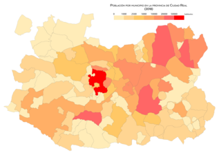
Population by municipality in 2018
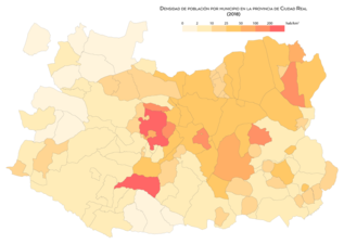
Population density by municipality in 2018

Population growth by municipality between 1998 and 2008

Population growth by municipality between 2008 and 2018


Demographic evolution
| Graphic of demographic evolution of the province of Ciudad Real between 1960 and 2020 |
 |
Population according to INE's 2020 municipal standards. Source: Spanish National Statistical Institute - Graphical development by Wikipedia. |
Communications

The province is located on the road from Toledo to Andalusia, Spain's main communication route for practically all of its history, so transportation has never been a problem in Ciudad Real. The A-4 highway crosses the province from north to south between Puerto Lápice and Almuradiel on its way from Madrid to Andalusia. The capital, Puertollano and other towns are linked to this highway through the A-43 and A-41 highways. The northeast of the province is also connected via the Los Viñedos highway.
The Spanish High Speed (AVE) route has stops in the towns of Ciudad Real and Puertollano.
The inauguration at the end of 2008 of the Ciudad Real airport has provided the province with air communication.
Political organization
_edited.jpg)
The highest strictly provincial political representation is the Provincial Council of Ciudad Real, chaired since 2015 by José Manuel Caballero Serrano (PSOE). The headquarters of the Provincial Council is located in the capital of the province. The central government is represented by the sub-delegate of the Government, while the regional government, the Castilla-La Mancha Community Board, is represented by the Board's delegate.
The province elects five deputies for the Congress of Deputies and four senators. In the last general elections of June 2016, three deputies and three senators from the PP and two deputies and 1 senator from the PSOE were elected.
Judicially, the province is divided into ten districts: Alcázar de San Juan, Ciudad Real, Daimiel, Manzanares, Valdepeñas, Villanueva de los Infantes, Puertollano, Tomelloso, Almagro and Almadén.