
Carnota (A Coruña)
Carnota is a coastal municipality located in the southwest area of La Coruña (Galicia, Spain), belonging to the Muros region. Its name could come from the pre-Celtic voice carn (stone).
Limits
The municipality of Carnota borders to the north with the municipality of Dumbría, to the northwest with Mazaricos, to the west with the Atlantic Ocean, and to the south with Muros.
History
There are burial mounds and fortifications that indicate that the area was inhabited since ancient times. In the Middle Ages it belonged to the counts of Trastámara and Lemos and was part of the old county of Cornatum. With the Great Irmandiña War of 1467, the fortresses disappeared. The place of the capital, Carnota, was born in the seventeenth century. In the 19th century it was sacked by French troops in the Spanish War of Independence.
Climate
The municipality of Carnota is under the influence of the European Atlantic climate characterized by the presence of abundant rains almost all year round, little thermal oscillation and abundant storms in winter. The average precipitation is 1650 mm and the average temperature is 16.2 °C.
Economy
Its economy is characterized by a low overall development with a clear predominance of fishing activity, a high degree of emigration in the past and even in the present, and weakness in the industrial and tourist sectors. The new developments in non-extractive fishing, the increasing use of wind energy and the still incipient rural tourism could change this situation in the future.
Demographics
| Evolution of the population of Carnota (La Coruña) - from 1900 to 2011 - | |||||||
| 1900 | 1930 | 1950 | 1981 | 2004 | 2007 | 2010 | 2011 |
| 5.507 | 6.594 | 7.196 | 7.213 | 5.285 | 5.017 | ♪ | ♪ |
| Sources: INE and IGE
(Censal registration criteria varied between 1900 and 2011, and INE and IGE data may not match.) | |||||||
parishes
parishes that are part of the municipality:
- Carnota (San Mamed).
- Lariño (San Martín).
- Lira (Santa Maria).
- Pindo (San Clemente).
- Santa Comba de Carnota (Santa Comba).
Monuments

- In Carnota is one of the largest hórreos in Spain, with almost 35 m long, and therefore of the world, since these constructions are originating and unique from the northwest of the Iberian peninsula. The biggest one we can find in Líra, although it only exceeds it for a few centimeters and is in worse condition of conservation.
- Its natural spaces are of great interest: Mount Pindo, mouth of the river Jallas, beach and marshes of Carnota and the islands Lobeiras. La beach of Carnota it has more than seven kilometers of sand and five of rocky beach. A sand dune forms towards the interior a small marshes that hosts different aquatic birds in winter.
Beaches
Numerous sandy beaches and stretches of rocky coastline dot its coastline: San Pedro (del Pindo), Quilmas, Pedrullo, Corna Becerra, Area Blanca, Porto Negro, Caldebarcos, Boca do Río, Carnota, Mar de Lira, Cons, Xaxebe, Porto Cubelo, Tras Punta, Portoancho, Gavota, Porto da Barca, Simprón, Ardeleiro, Susiños, Suresco, Porto dos Botes, Lariño and Punta de Caldebarcos, Punta dos Remedios, and Punta Insua (with its lighthouse) enter the good sea.
In addition to the above, in Carnota there is also Insuela beach, corresponding to the village of Panchés, located before Caldebarcos beach, as well as innumerable smaller coves, such as Rego da Braña, Gramelo and Sarradela.

Brotherhoods
- Spain
 Spain: Puerto del Rosario, Fuerteventura (since 2007)
Image gallery

Aerogenerators in the mountains of Pindo.
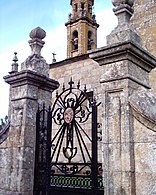
View of the Church of San Mamede de Carnota from the gate of the court.
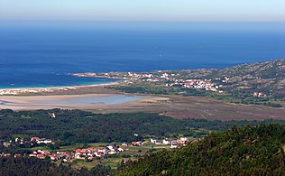
Playa de Carnota.
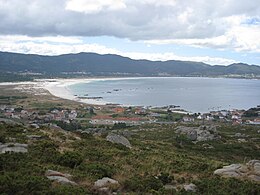
Playa de Carnota from Caldebarcos.


Contenido relacionado
Martin de Yeltes
Vermont
Aka